|
<< Click to Display Table of Contents >> Information Tab |
  
|
|
<< Click to Display Table of Contents >> Information Tab |
|
The Information tab is used to specify the general information for the station.
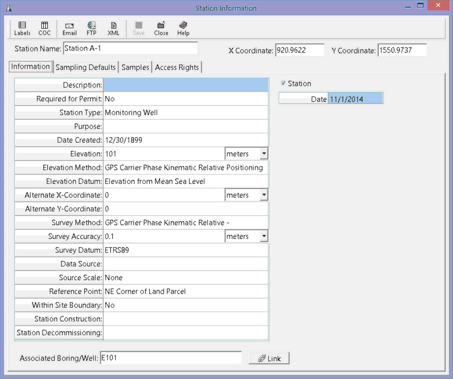
The following information can be specified on this tab:
Description: This is a description of the station.
Required for Permit: Select Yes if this task is required to maintain a permit for he project.
Station Type: This is used to select the type of station from the list of Station Types.
Purpose: This is the purpose of the station.
Date Created: This is used to select the date the station was created.
Elevation: This is the elevation of the ground surface at the station and units of the elevation of the station.
Elevation Method: This is used to select the method used to obtain the elevation from a list of Elevation Methods.
Elevation Datum: This is used to select the reference datum of the elevation datum from a list of Elevation Datums.
Alternate X-Coordinate: This is used to specify an alternate x coordinate for the station and the units for the alternate coordinates.
Alternate Y-Coordinate: This is used to specify an alternate y coordinate for he station.
Survey Method: This is used to select the survey method from a list of Survey Methods.
Survey Accuracy: This is used to specify the survey accuracy and the units for the accuracy.
Survey Datum: This is used to select the reference datum for the latitude and longitude from a list of Survey Datums.
Data Source: This is used to specify the data source.
Source Scale: This is the scale of source used to determine the latitude and longitude and is selected from a list of Source Scales.
Reference Point: This describes the location at which the coordinates were established and is selected from a list of Reference Points.
Within Site Boundary: Select Yes if the station is within the site boundaries of he project.
Station Construction: This is used to specify how the station was constructed.
Station Decommissioning: If the station has been decommissioned, this is used to specify how it was decommissioned.
Contractor: This is used to specify the contractor that constructed the station.
Associated Boring/Well: If the station is associated with a boring or well, it can be linked to the boring or well by pressing the Link button. The Select Borehole form will be displayed as described in the Select Borehole section..
Station Uploaded: If the station has been uploaded from EDMS Field this will be checked. This can not be edited.
Date Uploaded: If the station was uploaded, this displays the date it was uploaded from EDMS Field.