|
<< Click to Display Table of Contents >> Geometry Tab |
  
|
|
<< Click to Display Table of Contents >> Geometry Tab |
  
|
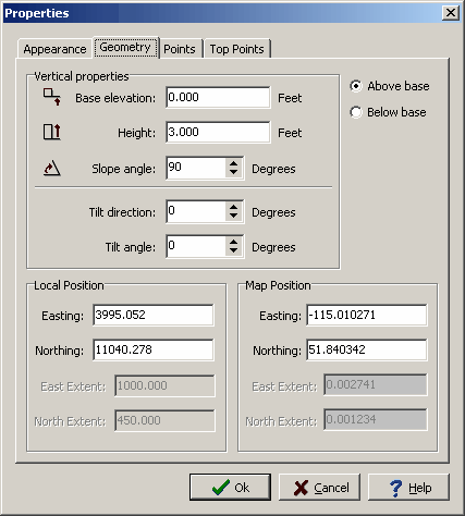
This tab will appear for all structures.

The following can be edited on this tab:
Base or Top Elevation: This is used to select whether the base or top elevation will be specified.
Elevation: This is the elevation of the base or top of the structure.
Height: This is the vertical height of the structure.
Slope Angle: This is the angle of the side slopes of the structure. A 90 degree angle would be a vertical side.
Tilt Direction: If the structure is tilted, this is the direction that is tilted. A 0 degree angle would be North.
Tilt Angle: This is the angle that it is tilted. A 0 degree angle is no tilt. If the structure is tilted the sides, top, and base will be tilted.
Local Easting: This is the minimum east position of the structure in local units.
Local Northing: This is the minimum north position of the structure in local units.
Local East Extent: This is the eastern extent of the structure in local units. If the structure type is a building, shaft, or excavation this field can not be edited.
Local North Extent: This is the northern extent of the structure in local units. If the structure type is a building, shaft, or excavation this field can not be edited.
Map Easting: This is the minimum east position of the structure in map units.
Map Northing: This is the minimum north position of the structure in map units.
Map East Extent: This is the eastern extent of the structure in map units. If the structure type is a building, shaft, or excavation this field can not be edited.
Map North Extent: This is the northern extent of the structure in map units. If the structure type is a building, shaft, or excavation this field can not be edited.