
May 2019: In version 4, StrataExplorer was renamed to GaeaSynergy to better reflect the purpose and benefits of the base application. GaeaSynergy is an application suite for geoscientific analyses, mapping, data display and data management. It uses the synergy within the geoscientific data to effectively and efficiently fulfill the needs of several industries.
The program can be used to evaluate contaminants, soil and rock properties, minerals deposits, and oil and gas deposits. It is ideal for the environmental, geotechnical, mining, oil sands, and petroleum industries.
GaeaSynergy is comprised of a base application and several optional modules. The base application is free and is used as a platform that all of the other modules build upon. The base application consists of the following components:
- Database Management
- License Management
- User Management
- GIS
- Mapping and Gridding (formerly SE-Map)
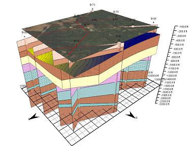
- 3D Display
- Import/Export
Using the optional modules, the program can be used to generate geotechnical test results and reports, lab analyses reports, boring and well logs, cross-sections, and fence diagrams.
The following optional modules are available:
- EDMS: Environmental Data Management System
- GDMS: Geotechnical Data Management System
- WinLoG: Well and Boring Log Module
- WinFence: Cross-section Module