
Introduction
Engineering and environmental projects rely heavily on drilling investigations to understand subsurface conditions. Boreholes provide direct observations of soil layers, rock formations, groundwater levels, and other geological characteristics that influence design decisions.
Large infrastructure developments such as highways, bridges, and tunnels depend on drilling investigations to determine soil strength, groundwater levels, and geological hazards that may affect construction.
Digital platforms integrate drilling records with laboratory systems, GIS mapping tools, and environmental monitoring databases.
Engineering Applications
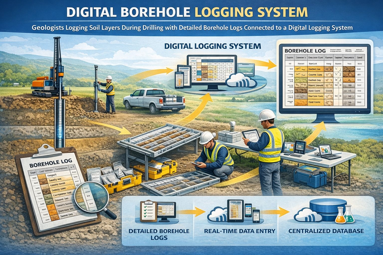
Subsurface investigations generate critical datasets used by geotechnical engineers, environmental scientists, and hydrogeologists. Borehole records document the materials encountered during drilling and provide valuable insight into underground conditions.
Environmental site assessments frequently rely on borehole sampling to determine whether contaminants are present in soil or groundwater.
Centralized borehole databases enable engineering organizations to reuse historical drilling investigations and analyze subsurface conditions across multiple projects.
Typical Borehole Data Collected
- Lithology descriptions
- Soil classification data
- Groundwater level measurements
- Sampling intervals
- Laboratory analytical results
- Drilling and borehole construction methods
Data Management and Technology
Engineering and environmental projects rely heavily on drilling investigations to understand subsurface conditions. Boreholes provide direct observations of soil layers, rock formations, groundwater levels, and other geological characteristics that influence design decisions.
Environmental site assessments frequently rely on borehole sampling to determine whether contaminants are present in soil or groundwater.
Modern borehole data solutions store drilling records within structured databases that allow engineers to organize geological logs, laboratory results, and monitoring data in a consistent format.
Conclusion
Engineering and environmental projects rely heavily on drilling investigations to understand subsurface conditions. Boreholes provide direct observations of soil layers, rock formations, groundwater levels, and other geological characteristics that influence design decisions.
Environmental site assessments frequently rely on borehole sampling to determine whether contaminants are present in soil or groundwater.
Centralized borehole databases enable engineering organizations to reuse historical drilling investigations and analyze subsurface conditions across multiple projects.
For a broader overview see the guide: The Complete Guide to Borehole Data Solutions.
Learn more about our Solutions
Related Articles
Explore additional articles in the Borehole Data Solutions series.
- What is Borehole Data? A Complete Introduction
- Types of Borehole Data Collected During Drilling
- Borehole Logging Explained: Methods, Tools, and Data
- Digital Borehole Logging vs Traditional Field Logs
- Common Problems with Borehole Data Management
- Borehole Database Systems: How They Work
- How Borehole Data Supports Geotechnical Engineering
- How Borehole Data Supports Environmental Site Assessments
- The Role of Borehole Data in Groundwater Monitoring
- Integrating Borehole Data with GIS Systems
- Borehole Data Standardization and Data Quality
- Managing Borehole Data from Drilling Contractors
- Borehole Data Visualization and Subsurface Modeling
- Best Practices for Borehole Data Management
- How Borehole Databases Improve Engineering Projects
- Centralizing Borehole Data Across Multiple Projects
- Automating Borehole Log Generation
- Cloud-Based Borehole Data Solutions
- Borehole Data Integration with Laboratory Data
- Borehole Data Management for Large Infrastructure Projects
- Choosing Borehole Data Management Software
- WinLoG Borehole Logging Software for Managing Drilling Data
- Subsurface Data Management for Engineering Projects
- How Engineering Firms Build Centralized Geological Databases
- The Future of Digital Subsurface Investigation Data