
For decades, Microsoft Excel has been the default tool for managing geotechnical and environmental data. It’s familiar, flexible, and widely available.
But here’s the reality: Excel was never designed for geotechnical data management.
As projects become more complex—multi-borehole investigations, long-term groundwater monitoring, contaminant modeling—the limitations of spreadsheets become impossible to ignore.
In this guide, we’ll break down exactly why Excel fails for geotechnical data management, the risks it creates, and how modern platforms like GAEA’s GDMS solve these problems.
The Growing Complexity of Geotechnical Data
Today’s projects involve far more than simple borehole logs:
- Hundreds (or thousands) of boreholes
- Time-series groundwater monitoring data
- Laboratory results across multiple analytes
- Stratigraphic variability
- Integration with modeling tools
Managing this level of complexity in Excel leads to:
- Data fragmentation
- Version control issues
- Increased risk of errors
- Inefficient workflows
The Core Problem: Excel Is Not a Database
At its core, Excel is a flat file system, not a relational database.
What This Means
- No enforced relationships between datasets
- No data integrity constraints
- No built-in validation rules
- No structured schema
Real-World Impact
- Borehole data stored in separate sheets
- Lab results disconnected from sampling locations
- Duplicate entries across files
- Broken links and references
Bottom Line
Excel stores data—but it doesn’t manage it.
Problem #1: Data Duplication and Inconsistency
In Excel workflows, the same data often appears in multiple places:
- Field logs
- Lab spreadsheets
- Reporting templates
- Modeling inputs
What Goes Wrong
- Updates are not synchronized
- Different versions of the same dataset exist
- Errors propagate across files
Example
A groundwater concentration is updated in one sheet—but not in another. The result?
- Incorrect reports
- Misleading analysis
- Loss of credibility
Problem #2: No True QA/QC Framework
Quality assurance and quality control are critical in geotechnical and environmental work.
Excel Limitations
- No enforced validation rules
- Manual QA/QC processes
- Easy to override formulas
- Limited audit tracking
Consequences
- Inconsistent lithology descriptions
- Incorrect units
- Missing data fields
- Undetected errors
Why This Matters
Regulatory submissions require defensible, traceable data. Excel struggles to provide that.
Problem #3: Version Control Chaos
If you’ve ever worked with files named:
Boreholes_Final_v3.xlsxBoreholes_Final_v3_Updated.xlsxBoreholes_Final_v3_Updated_REAL.xlsx
…you’ve experienced Excel version control.
The Issue
- Multiple users editing different versions
- No central source of truth
- Confusion over which file is correct
Result
- Wasted time
- Data inconsistencies
- Increased project risk
Problem #4: Poor Scalability
Excel works fine for small datasets—but breaks down quickly as complexity grows.
Common Issues
- Slow performance with large datasets
- File corruption risks
- Difficulty handling time-series data
- Limited ability to manage relationships
Example
Try managing:
- 50 monitoring wells
- 10 years of quarterly sampling
- 30 analytes
In Excel—and keeping it clean.
Problem #5: No Integration with Modeling Tools
Modern workflows require seamless integration between:
- Data collection
- Data management
- Modeling
- Reporting
Excel Problem
Data must be:
- Exported
- Reformatted
- Re-imported
For use in tools like:
- POLLUTE
- MIGRATE
Result
- Duplicate work
- Increased error risk
- Slower workflows
Problem #6: Limited Visualization and Reporting
Excel can create charts—but complex geotechnical visualization is limited.
Missing Capabilities
- Automated borehole logs
- Stratigraphic visualization
- Multi-well data comparison
- Dynamic reporting
Impact
- More manual work
- Inconsistent outputs
- Reduced clarity for clients
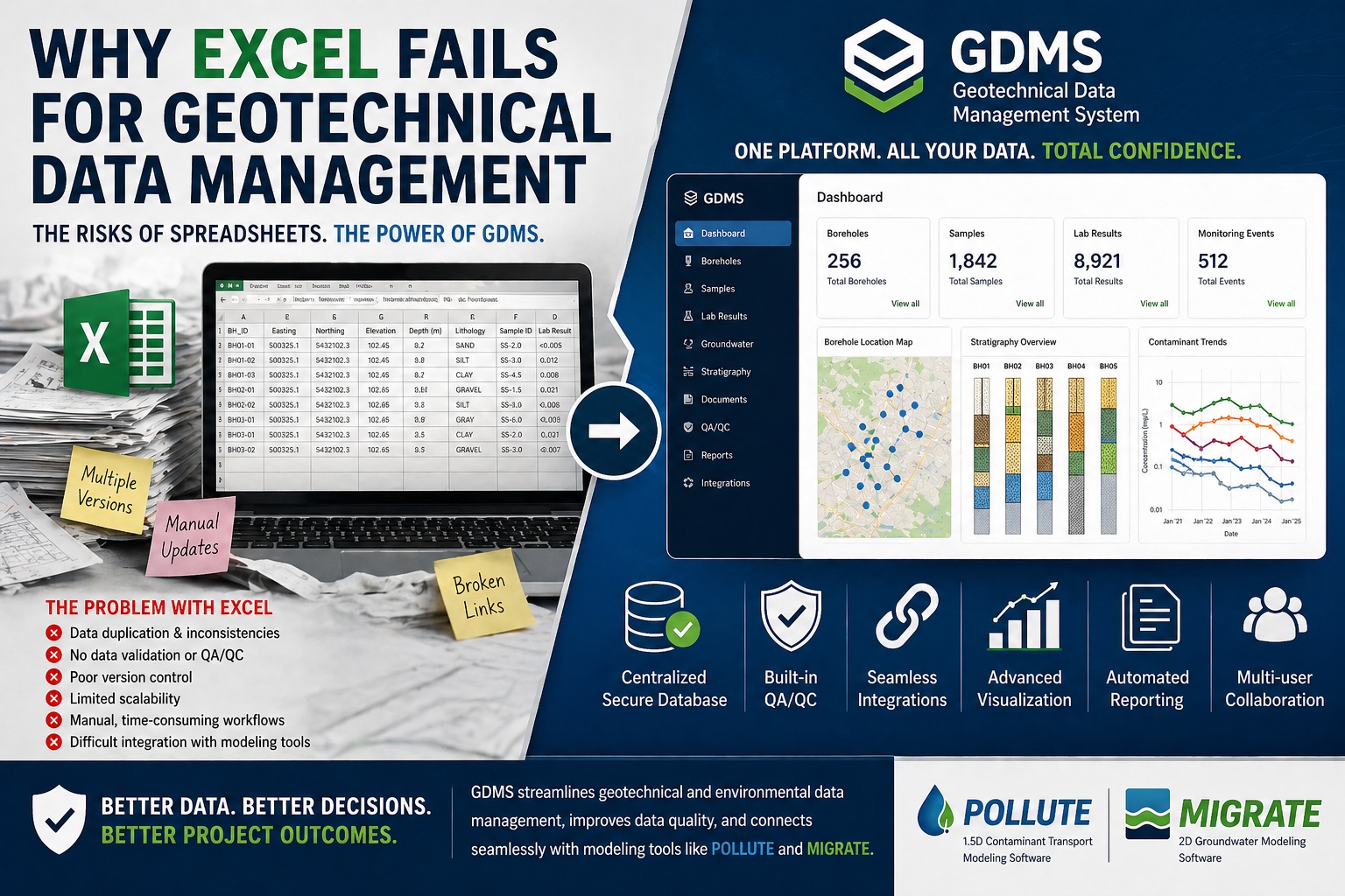
The Solution: GAEA’s GDMS (Geotechnical Data Management System)
To overcome these limitations, firms are moving to dedicated systems like GAEA’s GDMS.
GDMS is designed specifically for managing complex geotechnical and environmental datasets.
What Makes GDMS Different?
1. Centralized Database
GDMS provides a single source of truth:
- All borehole data in one place
- Lab results linked to samples
- Monitoring data tied to locations
Result
No duplication. No inconsistencies.
2. Built-In Data Relationships
Unlike Excel, GDMS understands how data connects:
- Borehole → sample → lab result
- Well → time-series data
- Stratigraphy → depth intervals
Benefit
Accurate, structured data that reflects real-world systems.
3. Automated QA/QC
GDMS enforces:
- Required fields
- Valid ranges
- Consistent units
- Data validation rules
Outcome
Higher data quality with less manual effort.
4. Seamless Integration with Modeling Tools
GDMS integrates directly with:
- POLLUTE
- MIGRATE
Workflow Advantage
- No reformatting
- No duplicate entry
- Faster model setup
5. Scalable for Large Projects
GDMS is built to handle:
- Thousands of boreholes
- Long-term monitoring datasets
- Multi-site projects
Result
Performance and reliability at scale.
6. Advanced Reporting and Visualization
With GDMS, you can:
- Generate borehole logs automatically
- Visualize stratigraphy
- Analyze groundwater trends
- Create consistent reports
Impact
Faster reporting with higher-quality outputs.
Excel vs GDMS: A Direct Comparison
| Feature | Excel | GDMS |
|---|---|---|
| Data structure | Flat | Relational |
| QA/QC | Manual | Automated |
| Version control | Poor | Centralized |
| Scalability | Limited | High |
| Modeling integration | Manual | Seamless |
| Reporting | Basic | Advanced |
Real-World Workflow Comparison
Excel-Based Workflow
- Enter field data manually
- Re-enter lab data
- Copy into reporting templates
- Reformat for modeling
- Perform manual QA/QC
Result: Slow, error-prone, fragmented
GDMS Workflow
- Capture and store data centrally
- Automatically link datasets
- Validate data in real time
- Export directly to modeling tools
- Generate reports instantly
Result: Fast, accurate, scalable
ROI: Why Moving Beyond Excel Matters
Switching from Excel to a system like GDMS delivers:
Efficiency Gains
- Reduce data handling time by 50–70%
- Eliminate duplicate entry
Risk Reduction
- Fewer errors
- Better data traceability
Business Impact
- Faster project delivery
- Higher client confidence
- Stronger regulatory defensibility
When Is It Time to Move Beyond Excel?
If you’re experiencing any of the following, it’s time:
- Multiple versions of the same dataset
- Frequent data inconsistencies
- Increasing project complexity
- Slow reporting workflows
- Difficulty integrating with models
Final Thoughts
Excel isn’t “bad”—it’s just the wrong tool for modern geotechnical data management.
As projects grow in complexity, the need for:
- Structured data
- Automated QA/QC
- Integrated workflows
- Scalable systems
Becomes unavoidable.
Platforms like GDMS are not just upgrades—they’re a fundamental shift in how environmental and geotechnical data is managed.
Because in today’s projects, success isn’t just about collecting data.
It’s about managing it correctly, efficiently, and defensibly.