

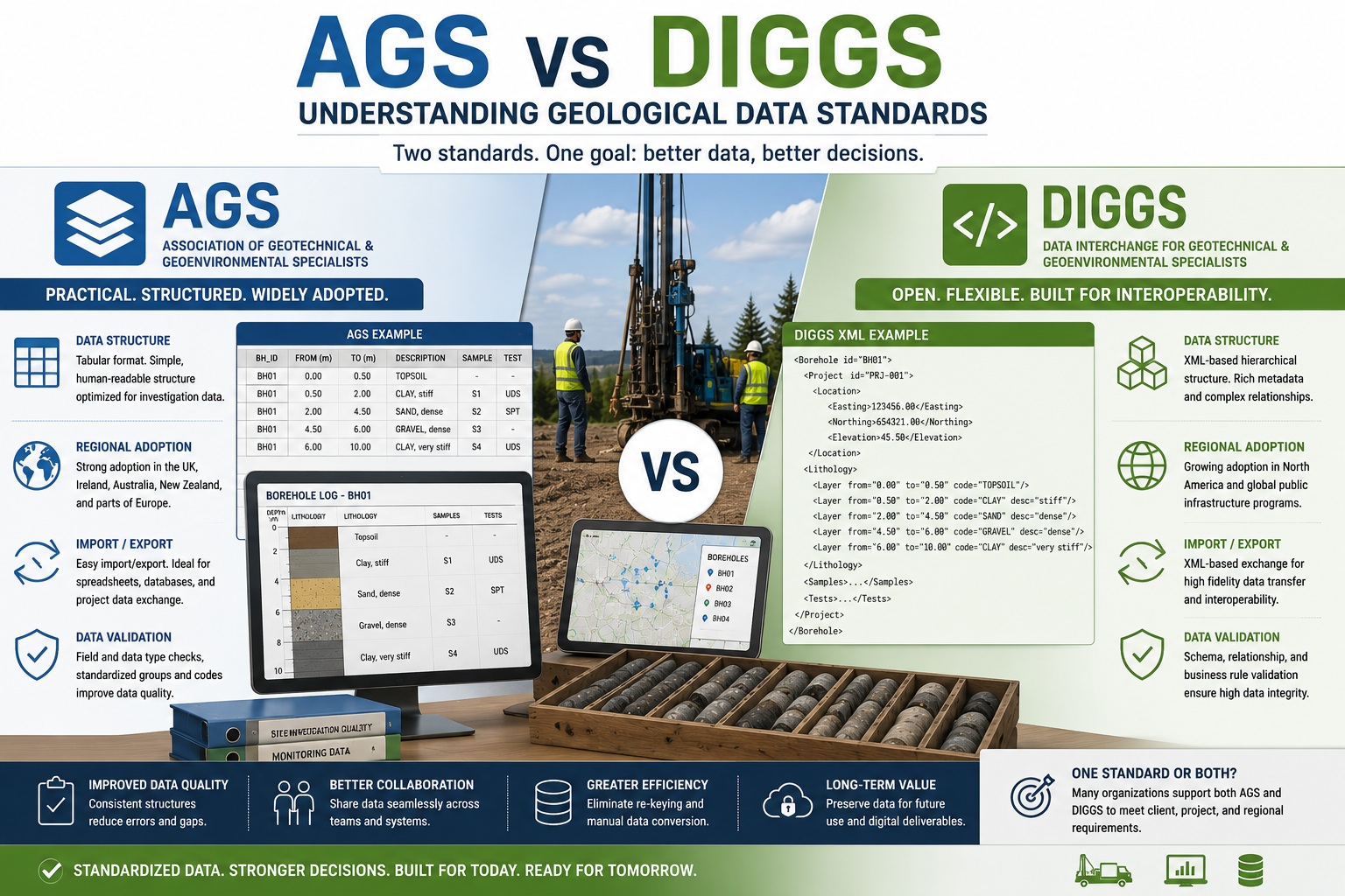
Comparing Two of the Most Important Standards in Geotechnical and Geological Data Exchange
As the geological, geotechnical, environmental, and infrastructure industries continue their digital transformation, the ability to exchange structured data between organizations and software systems has become increasingly important. Projects generate enormous amounts of information, including borehole logs, laboratory results, geotechnical testing data, groundwater observations, environmental monitoring records, and engineering analyses.
Historically, much of this information has been exchanged through reports, spreadsheets, PDFs, and proprietary database formats. While these methods remain common, they often create challenges related to data quality, interoperability, duplication of effort, and long-term data management.
To address these issues, several industry standards have emerged to support the exchange of structured geotechnical and geological information. Two of the most widely recognized standards are AGS and DIGGS.
Although both standards aim to improve data sharing and reduce manual data handling, they were developed in different regions, use different approaches, and have distinct strengths and adoption patterns.
This article examines AGS and DIGGS, their key differences, regional adoption, import and export capabilities, and how they support data validation and quality assurance.
Why Geological Data Standards Matter
Before comparing AGS and DIGGS, it is important to understand why standards are needed.
A typical investigation may involve:
- Drilling contractors
- Geologists
- Geotechnical engineers
- Environmental consultants
- Laboratories
- Project owners
- Government agencies
Each organization may use different software systems.
Without standardized data exchange, information often needs to be:
- Re-entered
- Reformatted
- Converted
- Verified
- Corrected
This process increases:
- Cost
- Time
- Error potential
- Data loss risk
Data standards help solve these problems by providing a common framework for exchanging information.
What Is AGS?
AGS stands for the Association of Geotechnical and Geoenvironmental Specialists data format.
The AGS format was originally developed in the United Kingdom to standardize geotechnical and geoenvironmental data exchange.
Its primary objective is to enable consistent transfer of investigation data between:
- Site investigation contractors
- Consultants
- Laboratories
- Infrastructure owners
- Government agencies
AGS has become one of the most widely used geotechnical data exchange formats globally.
AGS Structure
AGS typically uses a tabular structure.
Data is organized into groups and fields representing:
- Boreholes
- Samples
- Laboratory tests
- Monitoring data
- Geology
- Geotechnical observations
The format is designed to be relatively easy to import into spreadsheets and databases.
This simplicity has contributed significantly to its adoption.
What Is DIGGS?
DIGGS stands for:
Data Interchange for Geotechnical and Geoenvironmental Specialists
DIGGS was developed as an open international standard focused on structured geotechnical information exchange.
Unlike AGS, DIGGS is based on XML technology.
The objective is to provide a more comprehensive framework for exchanging:
- Borehole information
- Laboratory data
- Groundwater observations
- Geotechnical testing
- Environmental records
- Project metadata
DIGGS places a strong emphasis on interoperability and machine-readable structured data.
Key Differences Between AGS and DIGGS
Although AGS and DIGGS share many goals, they differ significantly in design philosophy and implementation.
1. Data Structure
AGS
AGS uses a structured tabular format.
Advantages include:
- Human-readable
- Spreadsheet-friendly
- Relatively simple implementation
DIGGS
DIGGS uses XML-based hierarchical structures.
Advantages include:
- Greater flexibility
- Rich metadata support
- Complex relationship modeling
Comparison
| Feature | AGS | DIGGS |
|---|---|---|
| Structure | Tabular | XML |
| Complexity | Lower | Higher |
| Human Readability | High | Moderate |
| Machine Readability | Good | Excellent |
| Metadata Support | Moderate | Extensive |
2. Scope
Another key difference involves scope.
AGS Focus
AGS was designed primarily around geotechnical investigation data.
Examples include:
- Boreholes
- Samples
- Laboratory testing
- Field observations
Its focus remains highly practical and investigation-oriented.
DIGGS Focus
DIGGS was developed to support broader data interoperability.
In addition to traditional geotechnical data, DIGGS can accommodate:
- Geoenvironmental information
- Hydrogeological data
- Project metadata
- Complex data relationships
DIGGS is often viewed as more extensible for future applications.
Regional Adoption
One of the most significant differences between AGS and DIGGS involves regional usage.
AGS Adoption
AGS originated in the United Kingdom and remains particularly strong in:
- United Kingdom
- Ireland
- Australia
- New Zealand
- Parts of Europe
Many consulting firms and contractors in these regions routinely exchange AGS files.
Infrastructure owners frequently require AGS deliverables.
DIGGS Adoption
DIGGS has gained stronger traction in:
- United States
- North America
- Government infrastructure programs
- Transportation agencies
- Public works organizations
Several public-sector initiatives have promoted DIGGS as part of broader digital infrastructure strategies.
Global Trends
Increasingly, software vendors support both standards.
This reflects the reality that many organizations operate internationally and must exchange information with clients using different requirements.
Import and Export Capabilities
Modern geotechnical software increasingly provides import and export functionality for both AGS and DIGGS.
This is essential for maintaining interoperability.
AGS Import and Export
Many systems support:
- AGS data import
- AGS data export
- Spreadsheet conversion
- Database mapping
The relative simplicity of AGS often makes implementation straightforward.
DIGGS Import and Export
DIGGS import and export typically involve:
- XML processing
- Schema validation
- Metadata mapping
- Structured relationship management
Although implementation can be more complex, DIGGS often preserves more contextual information.
Why Import/Export Matters
Without robust import/export capabilities:
- Data may require manual re-entry
- Errors may be introduced
- Valuable metadata may be lost
Organizations increasingly seek software that can exchange information seamlessly across multiple standards.
Data Validation
One of the greatest benefits of structured standards is improved validation.
AGS Validation
AGS supports validation through:
- Field definitions
- Data type controls
- Standardized groups
- Consistent coding structures
Validation can identify issues such as:
- Missing values
- Invalid codes
- Formatting errors
DIGGS Validation
DIGGS supports more sophisticated validation because of its XML structure.
Examples include:
- Schema validation
- Relationship validation
- Metadata verification
- Hierarchical consistency checks
DIGGS can validate not only individual fields but also relationships between datasets.
QA/QC Benefits
Both standards improve QA/QC by enabling:
- Automated checks
- Standardized workflows
- Reduced ambiguity
- Consistent data structures
This improves confidence in exchanged information.
Metadata Management
Metadata is becoming increasingly important in modern geological databases.
Metadata describes:
- Data source
- Coordinate systems
- Methods
- Equipment
- Users
- Revision history
AGS Metadata Support
AGS supports metadata but generally focuses on practical project data exchange.
DIGGS Metadata Support
DIGGS was designed with extensive metadata capabilities.
This makes it particularly attractive for:
- Long-term archival
- Government repositories
- Enterprise data management
- Digital twin initiatives
Government and Infrastructure Adoption
Government agencies increasingly require digital data deliverables.
Both AGS and DIGGS support these objectives.
AGS in Infrastructure Projects
AGS is commonly required for:
- Transportation projects
- Rail investigations
- Highway development
- Utility corridors
particularly in the UK and Commonwealth countries.
DIGGS in Public Programs
DIGGS has gained support among:
- Transportation departments
- Infrastructure agencies
- Environmental organizations
- Public works departments
particularly in North America.
The emphasis on structured, machine-readable information aligns well with modern digital asset management programs.
Which Standard Is Better?
The answer depends on project requirements.
AGS Advantages
- Simpler implementation
- Broad industry acceptance
- Strong regional adoption
- Easy spreadsheet integration
- Efficient project data exchange
DIGGS Advantages
- Rich XML structure
- Extensive metadata support
- Strong interoperability
- Advanced validation capabilities
- Future-ready architecture
The Reality
For many organizations, the best solution is not choosing one standard over the other.
Instead, it is selecting software capable of supporting both.
This provides maximum flexibility when working with clients, regulators, consultants, and contractors in different regions.
The Future of Geological Data Standards
The demand for structured geotechnical data continues to grow.
Emerging technologies such as:
- Building Information Modeling (BIM)
- Geographic Information Systems (GIS)
- Digital twins
- Artificial Intelligence (AI)
- Automated QA/QC
all depend on standardized and interoperable data.
Both AGS and DIGGS will likely continue evolving to support these requirements.
Organizations that adopt standards-based workflows today will be better positioned to participate in increasingly connected digital ecosystems.
Conclusion
AGS and DIGGS are two of the most important standards for exchanging geological, geotechnical, and geoenvironmental information. While AGS offers a practical, widely adopted tabular format that is especially popular in the United Kingdom and other Commonwealth regions, DIGGS provides a highly structured XML-based framework designed for advanced interoperability and long-term digital data management. Both standards improve data quality, support automated validation, reduce manual data handling, and enhance collaboration between organizations. Rather than viewing AGS and DIGGS as competing standards, many organizations benefit from supporting both formats, allowing them to exchange information efficiently across projects, regions, and software platforms while preparing for the future of digital geotechnical data management.