
Introduction
Seismic data has long been a cornerstone of subsurface exploration, enabling geoscientists to visualize geological structures, identify hydrocarbon reservoirs, map aquifers, and support environmental investigations. For decades, seismic surveys were recorded and stored in analog formats such as paper seismic sections, film reels, and microfiche. While these legacy datasets contain immense geological value, their analog nature limits accessibility, integration, and long-term usability.
Today, the geoscience industry is undergoing a digital transformation. Organizations are increasingly investing in converting analog seismic profiles into digital seismic datasets that can be integrated into modern interpretation platforms, machine learning workflows, and cloud-based data ecosystems.
This article provides a comprehensive overview of how analog seismic profiles are converted into digital seismic data, including workflows, technologies, challenges, quality control practices, and the strategic benefits of digitization.
Understanding Analog Seismic Profiles
Analog seismic profiles are typically 2D seismic reflection records that display the response of subsurface geological layers to seismic energy.
Historically, these profiles were:
- Printed as long paper sections using plotters
- Recorded on photographic film
- Stored on microfiche for archival purposes
These profiles often include:
- Wiggle traces representing seismic amplitudes
- Variable density shading
- Time scales (in milliseconds)
- Shot points or distance markers
- Survey identifiers and annotations
While visually rich, analog seismic profiles are not directly usable in modern digital workflows.
Why Convert Analog Seismic Data to Digital?
Converting analog seismic profiles into digital formats unlocks a wide range of benefits.
Improved accessibility
Digital data can be stored, searched, and accessed instantly from centralized databases or cloud platforms.
Integration with modern software
Digital seismic datasets can be imported into interpretation software such as Petrel, Kingdom, and OpendTect.
Enhanced interpretation capabilities
Digital data enables advanced analysis techniques, including attribute analysis, inversion, and machine learning.
Data preservation
Digitization protects seismic data from physical degradation and loss.
Cost efficiency
Reusing existing seismic data eliminates the need for expensive re-acquisition.
These advantages make digitization a critical step in modern subsurface data management strategies.
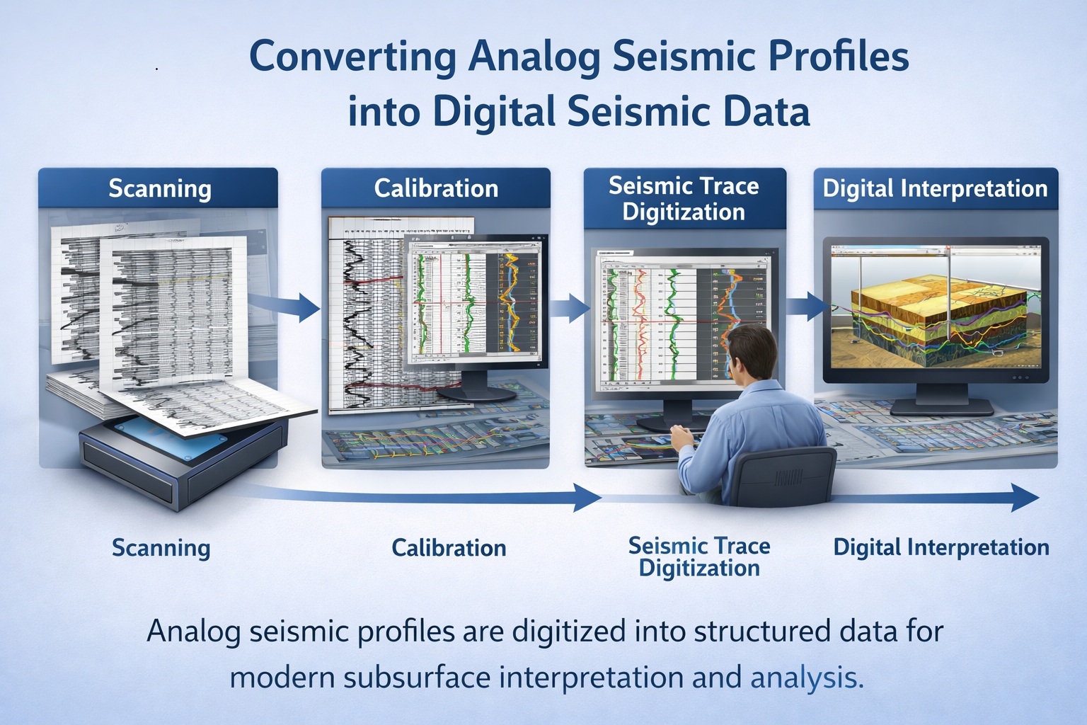
The Conversion Workflow: From Analog to Digital
The process of converting analog seismic profiles into digital datasets involves several carefully controlled steps.
1. Data Inventory and Assessment
The first step is identifying and cataloging available seismic profiles.
This includes:
- Locating physical records
- Assessing condition and quality
- Identifying associated metadata
- Prioritizing datasets for digitization
A well-organized inventory ensures efficient project execution.
2. High-Resolution Scanning
Analog seismic profiles are digitized by scanning them into high-resolution images.
Key scanning considerations include:
- Resolution of 300–600 DPI
- Use of large-format scanners
- Preservation of grayscale or color information
- Minimizing geometric distortion
Lossless formats such as TIFF are typically used to maintain image quality.
3. Image Preprocessing
Scanned images often require enhancement before further processing.
Preprocessing steps include:
- Deskewing and alignment
- Contrast adjustment
- Noise reduction
- Background cleaning
These improvements help clarify seismic traces and prepare the data for digitization.
4. Calibration of Axes
Calibration is essential for converting image pixels into meaningful seismic data.
This involves mapping:
- Vertical axis → time (milliseconds)
- Horizontal axis → distance or shot points
Reference points such as scale bars and grid lines are used for calibration.
Accurate calibration ensures that digitized data align with real-world coordinates.
5. Seismic Trace Digitization
The core of the conversion process is extracting numerical data from the seismic image.
Several approaches are used:
Manual digitization
Technicians trace seismic reflections manually.
Semi-automated digitization
Software assists in identifying and tracing seismic features.
Automated digitization
Advanced algorithms extract seismic traces using image processing and AI techniques.
The method chosen depends on data quality and project requirements.
6. Data Reconstruction
Once traces are digitized, they are reconstructed into digital seismic datasets.
This may include:
- Rebuilding amplitude values
- Creating seismic trace files
- Structuring data into standard formats
The goal is to produce data compatible with interpretation software.
7. Quality Control and Validation
Quality control ensures that digitized data accurately represent the original seismic profiles.
QC procedures include:
- Visual comparison with original images
- Verification of calibration accuracy
- Detection of digitization artifacts
- Cross-checking with nearby seismic data
Combining automated checks with expert review yields the best results.
Output Formats for Digital Seismic Data
Digitized seismic data can be stored in several industry-standard formats.
SEG-Y
The most widely used format for seismic data storage and exchange.
SEG-D
Used for field data acquisition.
Image-based formats
High-resolution images used for interpretation overlays.
ASCII formats
Used for simplified data representation and analysis.
Selecting the appropriate format depends on the intended use of the data.
Challenges in Seismic Data Conversion
Converting analog seismic profiles into digital data presents several challenges.
Data quality issues
Old seismic profiles may suffer from fading, noise, or physical damage.
Complex trace patterns
Overlapping traces and dense wiggle patterns can complicate digitization.
Incomplete metadata
Missing survey parameters can hinder accurate calibration.
Interpretation uncertainty
Digitization may introduce ambiguity in areas with weak or noisy signals.
Addressing these challenges requires a combination of technology and expert interpretation.
Role of Quality Control in Seismic Digitization
Quality control is essential for ensuring the reliability of digitized seismic data.
Effective QC includes:
Multi-stage validation
Quality checks at each stage of the workflow.
Automated anomaly detection
Algorithms identify spikes, gaps, and inconsistencies.
Expert review
Geophysicists verify geological plausibility.
Cross-validation
Comparison with well logs and other datasets.
Robust QC processes ensure that digitized data can be trusted for interpretation.
Integrating Digital Seismic Data into Modern Workflows
Once converted, digital seismic data can be integrated into advanced geoscience workflows.
Interpretation software
Platforms such as Petrel and Kingdom allow detailed subsurface analysis.
3D modeling
Digitized 2D profiles can be incorporated into 3D geological models.
Machine learning
Digital datasets can be used to train AI models for pattern recognition.
Cloud-based systems
Data can be shared across teams and accessed remotely.
This integration significantly enhances the value of seismic data.
Applications Across Industries
Digitized seismic data supports a wide range of applications.
Oil and gas exploration
Identifying reservoirs and structural traps.
Mining
Mapping geological structures associated with mineral deposits.
Environmental studies
Assessing subsurface conditions for remediation projects.
Infrastructure development
Evaluating ground conditions for construction projects.
Carbon capture and storage
Identifying suitable geological formations for CO₂ storage.
Leveraging AI and Machine Learning
The digitization of seismic data enables the use of AI technologies.
Applications include:
- Automated fault detection
- Horizon picking
- Seismic facies classification
- Predictive modeling
Historical seismic data provides valuable training datasets for these models.
Preserving Legacy Data for Future Generations
Analog seismic profiles represent decades of exploration effort and investment.
Digitization ensures that this knowledge is preserved and remains accessible.
Without digitization, valuable data may be lost due to:
- Physical degradation
- Obsolete storage formats
- Organizational changes
Preserving these datasets supports long-term scientific and industrial progress.
Best Practices for Successful Conversion
Organizations should follow best practices to ensure successful seismic digitization projects.
Use high-quality scanning equipment
Ensures accurate capture of seismic details.
Maintain data integrity
Preserve original scans before processing.
Document metadata thoroughly
Essential for calibration and interpretation.
Implement robust QC workflows
Ensures reliable results.
Involve experienced geoscientists
Critical for validating digitized data.
Following these practices improves project outcomes and data usability.
Future Trends in Seismic Digitization
Technological advancements are transforming seismic digitization.
AI-driven digitization
Automated extraction of seismic traces.
Cloud-based processing
Scalable and collaborative workflows.
Integration with digital twins
Combining seismic data with real-time subsurface models.
Enhanced visualization
Advanced 3D and immersive interpretation tools.
These trends will continue to enhance the value of digitized seismic data.
Conclusion
Converting analog seismic profiles into digital seismic data is a critical step in modernizing geoscience workflows. By transforming legacy datasets into structured digital formats, organizations can unlock valuable geological insights, improve interpretation accuracy, and support advanced analytical techniques.
The digitization process involves careful scanning, preprocessing, calibration, trace extraction, and rigorous quality control. While challenges exist, the benefits far outweigh the effort, enabling organizations to maximize the value of their historical seismic archives.
As the industry continues to embrace digital transformation, the conversion of analog seismic data will play a central role in bridging the gap between past exploration efforts and future subsurface discoveries.
Learn more about our Data Solutions
- Geophysical and well log digitization
- Seismic section digitization
- Map digitization
- Core photo splicing
- Scout ticket digitization
Related Articles
- Data Digitization and Management Solutions for Geoscience and Engineering
- Digitizing Vintage Seismic Sections for Modern Subsurface Interpretation
- Mining The Archive: Digitizing Historical Seismic Data For Critical Mineral Exploration
- 5 Steps To Convert Your Archive Into An AI-Ready Geospatial Pipeline
- Understanding SEG-Y Data Format
- Repurposing Legacy Seismic Data For Accelerated Carbon Capture Success
- Paper Vs. Profit: Calculating The ROI Of Seismic Section Digitization In 2026
- The Geothermal Goldmine: Finding Sustainable Heat Sources in Decades-Old Seismic Archives
- LAS, SEGY, and Beyond: Ensuring Interoperability For Your Newly Digitized Assets