

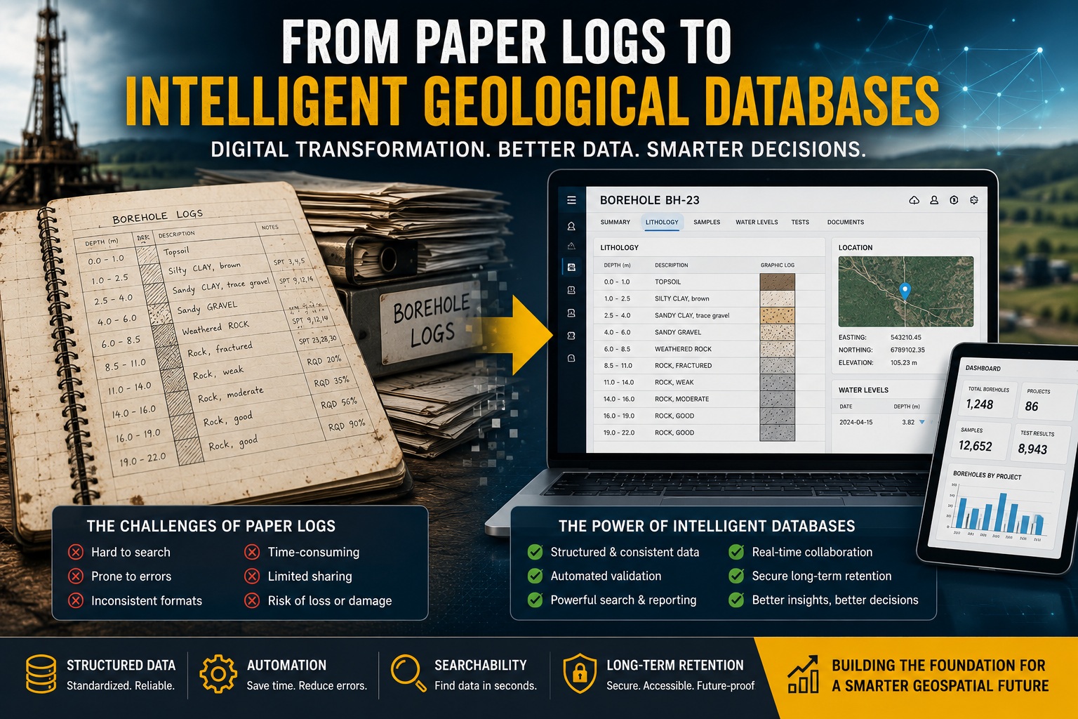
For decades, geological and geotechnical investigations relied heavily on handwritten field notes, printed borehole logs, spreadsheets, and filing cabinets filled with paper records. While these methods served the industry for many years, they also introduced major challenges involving data quality, accessibility, consistency, and long-term usability.
Today, the industry is undergoing a major digital transformation. Organizations are moving away from disconnected paper-based workflows toward intelligent geological databases that support automation, standardized data management, advanced analytics, and long-term data retention.
This shift is changing how geological, geotechnical, environmental, and mining projects are managed. Modern digital systems are improving data accuracy, increasing efficiency, reducing risk, and enabling better decision-making across the entire project lifecycle.
This article explores the evolution from traditional paper logs to intelligent geological databases and explains why digital transformation has become essential for modern subsurface investigations.
The Limitations of Paper-Based Geological Logging
Paper borehole logs were once the industry standard. Field geologists and drillers recorded lithology descriptions, sample intervals, groundwater observations, recovery values, and drilling notes manually in notebooks or printed forms.
Although familiar and simple, paper-based workflows introduced significant operational limitations.
Common Problems with Paper Logs
Manual Transcription Errors
Handwritten notes often needed to be re-entered into spreadsheets or databases later. Every manual transfer increased the risk of:
- Typographical mistakes
- Missing records
- Incorrect sample depths
- Illegible handwriting
- Unit conversion errors
Inconsistent Logging Standards
Without structured digital controls, different personnel frequently used different:
- Lithology descriptions
- Abbreviations
- Classification systems
- Units of measurement
- Coding conventions
This created inconsistent datasets that were difficult to analyze or compare.
Limited Searchability
Finding information in paper archives was slow and inefficient. Teams often spent hours searching for:
- Historical boreholes
- Laboratory results
- Groundwater records
- Old reports
- Site investigation data
In some cases, important records were permanently lost or misfiled.
Difficult Data Sharing
Paper records complicated collaboration between:
- Engineers
- Geologists
- Environmental consultants
- Regulators
- Contractors
Teams frequently worked from different versions of the same information, creating confusion and duplication.
Weak Auditability
Paper systems provided limited traceability. Organizations often struggled to determine:
- Who modified records
- When changes occurred
- Whether QA/QC reviews were completed
- Which data version was used in reports
This created legal and regulatory risks.
The Rise of Digital Geological Data Management
As projects became more complex and data-driven, organizations began adopting digital geological data management systems.
Initially, many companies simply transferred paper records into spreadsheets or basic databases. While this improved storage and sharing, it did not fully solve issues involving data quality, consistency, or automation.
Modern geological databases now provide far more advanced capabilities.
These systems support:
- Structured data management
- Automated QA/QC
- Integrated workflows
- GIS and CAD integration
- Laboratory imports
- Real-time field data capture
- Advanced reporting
- Long-term archival
The result is a far more reliable and scalable approach to subsurface data management.
Structured Data: The Foundation of Intelligent Databases
One of the biggest advantages of intelligent geological databases is structured data.
Structured data organizes information into standardized formats that computers can validate, search, analyze, and automate efficiently.
Instead of storing geological descriptions as inconsistent free text, structured systems use controlled fields and standardized relationships.
What Structured Geological Data Includes
Structured geological databases commonly organize:
- Borehole collars
- Lithology intervals
- Sample records
- Laboratory results
- Groundwater measurements
- Geotechnical tests
- Core recovery data
- Spatial coordinates
- Drilling metadata
- QA/QC records
Each dataset is linked relationally, allowing information to remain consistent and traceable.
Benefits of Structured Data
Improved Consistency
Standardized lookup tables and controlled vocabularies reduce inconsistent terminology.
For example:
- “Clayey Sand”
- “Sand with Clay”
- “Sandy Clay”
can be standardized according to project rules or classification systems.
Better Validation
Structured databases can automatically detect:
- Overlapping intervals
- Missing fields
- Invalid elevations
- Duplicate records
- Impossible coordinates
- Inconsistent recovery values
This dramatically improves data quality.
Faster Reporting
Because the data is standardized, reports and borehole logs can be generated automatically using templates and predefined workflows.
Easier Integration
Structured databases integrate more effectively with:
- GIS systems
- CAD software
- 3D geological modeling platforms
- Environmental databases
- Asset management systems
This improves collaboration across disciplines.
Automation: Reducing Manual Work and Human Error
Automation is one of the most important drivers behind digital geological transformation.
Traditional workflows relied heavily on repetitive manual processes such as:
- Re-entering field notes
- Formatting reports
- Checking intervals
- Matching laboratory data
- Updating spreadsheets
- Generating borehole logs
These activities consumed significant time and introduced opportunities for error.
How Automation Improves Geological Workflows
Modern intelligent databases automate many routine tasks.
Automated Validation
QA/QC engines can automatically flag:
- Depth mismatches
- Invalid lithology sequences
- Missing recovery values
- Duplicate sample IDs
- Coordinate errors
This helps identify problems immediately rather than months later.
Automated Laboratory Imports
Laboratory results can be imported directly into the database using standardized formats such as:
- AGS
- DIGGS
- CSV templates
- API integrations
This reduces transcription errors and accelerates reporting.
Automated Reporting
Digital systems can automatically generate:
- Borehole logs
- Fence diagrams
- Geological cross-sections
- Laboratory summaries
- Regulatory submissions
This significantly reduces repetitive drafting work.
Workflow Automation
Modern systems also support workflow tracking for:
- Data entry
- Review
- Validation
- Approval
- Revision control
This improves accountability and auditability.
Searchability: Unlocking the Value of Historical Data
One of the biggest advantages of intelligent geological databases is the ability to search and retrieve information instantly.
Organizations often possess decades of historical subsurface data stored in:
- Filing cabinets
- Archived PDFs
- Scanned documents
- Old spreadsheets
- Legacy databases
Without proper indexing and digital organization, much of this information becomes inaccessible.
Why Searchability Matters
Fast access to historical data supports:
- Site redevelopment
- Environmental assessments
- Regional geological interpretation
- Infrastructure planning
- Resource evaluation
- Litigation support
- Regulatory compliance
For example, engineers may need to quickly identify:
- Boreholes within a certain radius
- Historical groundwater levels
- Previous contamination results
- Rock quality trends
- Nearby geotechnical investigations
Intelligent databases make this possible within seconds.
Advanced Search Capabilities
Modern systems allow users to search by:
- Borehole ID
- Coordinates
- Project name
- Lithology type
- Date ranges
- Sample type
- Laboratory parameters
- Geological units
- Depth intervals
Some systems also support GIS-based spatial querying and interactive map visualization.
Long-Term Retention and Data Preservation
Subsurface data often remains valuable for decades.
A borehole drilled today may still be referenced:
- During future expansions
- For environmental monitoring
- In legal disputes
- During infrastructure upgrades
- For regional geological studies
Paper records deteriorate over time and are vulnerable to:
- Physical damage
- Water exposure
- Fire
- Misfiling
- Human loss
- Obsolete storage formats
Digital geological databases provide a far more reliable long-term retention strategy.
Benefits of Digital Long-Term Retention
Centralized Storage
Modern databases provide centralized repositories where all project data can be securely stored and backed up.
Version Control
Digital systems track revisions and maintain historical versions of records.
This improves:
- Auditability
- Legal defensibility
- Regulatory compliance
Data Preservation
Well-maintained digital systems reduce the risk of permanent data loss.
Easier Migration
Structured databases are easier to migrate into future software platforms compared to paper archives or disconnected spreadsheets.
Supporting Regulatory Compliance
Regulators increasingly expect digital, traceable, and standardized geological and environmental data.
Modern intelligent databases help organizations meet compliance requirements involving:
- Environmental reporting
- Groundwater monitoring
- Contaminated site management
- Mining regulations
- Infrastructure documentation
- QA/QC traceability
Audit trails and validation workflows strengthen regulatory confidence and improve defensibility during inspections or audits.
The Future of Intelligent Geological Databases
The evolution toward intelligent geological databases is continuing rapidly.
Emerging technologies include:
- Cloud-based collaboration
- Real-time mobile field logging
- AI-assisted lithology classification
- Automated anomaly detection
- Integrated 3D visualization
- Machine learning analytics
- Sensor and IoT integration
These technologies will further improve data quality, operational efficiency, and decision-making.
Organizations that continue relying on disconnected paper-based systems may struggle to remain competitive as industry expectations evolve.
Final Thoughts
The transition from paper logs to intelligent geological databases represents far more than a technology upgrade. It is a fundamental shift in how geological and geotechnical information is managed, validated, analyzed, and preserved.
Structured data, automation, searchability, and long-term retention are transforming subsurface investigations into more accurate, efficient, and reliable workflows.
Modern geological databases help organizations:
- Reduce errors
- Improve QA/QC
- Accelerate reporting
- Strengthen compliance
- Preserve institutional knowledge
- Support better engineering decisions
As the volume and complexity of geological data continue to grow, intelligent digital systems are becoming essential for successful project delivery and long-term data stewardship.