
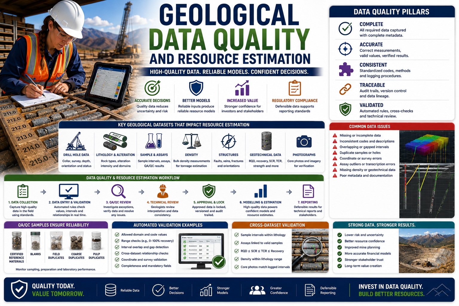
Why High-Quality Geological Data Is the Foundation of Reliable Mineral Resource Models
Every mineral resource estimate begins with geological data. Drill holes, core logs, assays, geotechnical measurements, structural observations, density determinations, and survey information collectively define the size, shape, grade, and confidence of a mineral deposit. Sophisticated geological modelling software and advanced geostatistical techniques can process millions of data points, but the quality of the resulting resource model will always depend on the quality of the underlying data.
The mining industry often refers to this concept as “Garbage In, Garbage Out.” No amount of advanced modelling can compensate for inaccurate drill hole locations, inconsistent lithology coding, poor sampling practices, incorrect assays, or missing geological information. Even relatively small data quality issues can introduce bias into resource estimates, influence investment decisions, affect mine planning, and ultimately impact the economic viability of a project.
Resource estimation is therefore as much a data quality exercise as it is a geological or statistical one. Successful exploration companies invest heavily in Quality Assurance (QA), Quality Control (QC), structured geological databases, automated validation, and independent technical review long before the first block model is generated.
This article examines the relationship between geological data quality and mineral resource estimation, highlighting best practices for ensuring that exploration data remains accurate, consistent, traceable, and suitable for confident decision-making.
Why Data Quality Matters
A mineral resource estimate is built from thousands—or sometimes millions—of individual observations.
These may include:
- Drill hole collars
- Downhole surveys
- Lithology intervals
- Alteration logs
- Structural measurements
- Assay results
- Density measurements
- Rock Quality Designation (RQD)
- Recovery data
- Geotechnical logging
- Core photographs
Errors in any of these datasets can influence the final geological model.
For example:
- Incorrect drill hole coordinates may shift mineralized zones.
- Poor lithology coding may distort geological domains.
- Assay errors may bias grade estimates.
- Missing density values may affect tonnage calculations.
- Incorrect downhole surveys may alter orebody geometry.
The cumulative effect of these errors can significantly reduce confidence in a resource estimate.
Resource Estimation Depends on Trustworthy Data
Modern resource estimation software performs complex calculations including:
- Geological domaining
- Wireframe generation
- Compositing
- Variography
- Grade interpolation
- Block modelling
- Classification
- Resource reporting
Each step assumes that the input data is accurate.
Poor data quality affects every subsequent stage of modelling.
Consequently, improving database quality often produces greater benefits than applying increasingly sophisticated estimation techniques.
Common Geological Data Quality Problems
Exploration databases commonly contain issues such as:
- Duplicate drill holes
- Missing survey data
- Inconsistent lithology codes
- Incorrect sample intervals
- Overlapping geological units
- Missing assays
- Incorrect density measurements
- Coordinate errors
- Incomplete metadata
- Broken database relationships
Many of these problems remain hidden until formal validation is performed.
Standardized Geological Logging
Consistency begins during field logging.
Every geologist should follow documented procedures covering:
- Lithology
- Alteration
- Mineralization
- Weathering
- Structures
- Veining
- Recovery
- RQD
- Sampling
Without standardized procedures, geological interpretation becomes increasingly subjective.
Controlled Vocabularies
Consider the following descriptions:
- Granite
- Biotite Granite
- Granitic Rock
- Granite (Pink)
- Pink Granite
Although similar, inconsistent terminology complicates domain modelling.
Controlled lithology codes improve:
- Searching
- Validation
- Geological modelling
- Reporting
Standardized coding reduces ambiguity across projects.
Sampling Quality
Assays represent one of the most valuable datasets within an exploration program.
Poor sampling practices cannot be corrected during modelling.
QA/QC should verify:
- Sample intervals
- Sample numbering
- Sample security
- Certified reference materials
- Blank samples
- Duplicate samples
- Laboratory performance
High-quality sampling improves confidence in grade estimation.
Collar and Survey Validation
Accurate drill hole positioning is fundamental.
Validation should verify:
- Collar coordinates
- Elevation
- Coordinate system
- Datum
- Downhole surveys
- Azimuth
- Dip
Incorrect survey information may distort the geological model long before grade interpolation begins.
Lithology Validation
Lithological interpretation controls geological domaining.
Validation should identify:
- Missing intervals
- Overlapping intervals
- Gaps
- Invalid codes
- Duplicate intervals
- Impossible depth relationships
Continuous lithological coverage is essential for reliable wireframes.
Recovery and Rock Quality Validation
Recovery, RQD, SCR, and TCR influence:
- Geotechnical assessment
- Structural interpretation
- Core quality
- Resource confidence
Automated rules should verify:
- Recovery ≤ 100%
- RQD ≤ SCR
- SCR ≤ TCR
- TCR ≤ Recovery
Logical consistency improves confidence in the geological record.
Density Data
Specific gravity or bulk density measurements directly influence tonnage calculations.
Validation should verify:
- Appropriate units
- Laboratory methods
- Representative sampling
- Duplicate measurements
- Missing density values
Incorrect density information can significantly affect reported resources.
Cross-Dataset Validation
Many exploration errors only become apparent when related datasets are compared.
Examples include:
| Dataset Comparison | Validation |
|---|---|
| Sample interval vs lithology | Sample within logged interval |
| Assay vs sample ID | Matching identifiers |
| Recovery vs RQD | RQD ≤ Recovery |
| Core photo vs logging | Complete documentation |
| Density vs lithology | Appropriate material |
Cross-dataset validation identifies inconsistencies before modelling begins.
Automated Validation Rules
Modern geological databases can automatically evaluate hundreds of validation rules.
Examples include:
Domain Validation
Only approved lithology codes allowed.
Range Validation
Recovery between 0–100%.
Interval Validation
No overlapping intervals.
Coordinate Validation
Valid coordinate ranges.
Completeness Validation
Required fields completed.
Automation significantly reduces manual QA effort.
Statistical Validation
Statistical analysis helps identify unusual values.
Examples include:
- Extreme assay grades
- Unusual densities
- Outlier recoveries
- Unexpected structural orientations
Outliers should be investigated—not automatically removed.
Some represent genuine mineralization.
Others indicate sampling or data entry errors.
Metadata Quality
Metadata often determines whether historical data remains useful decades later.
Examples include:
- Logger
- Logging date
- Drill contractor
- Survey method
- Laboratory
- Analytical method
- Coordinate system
- Equipment used
Without metadata, future interpretation becomes increasingly difficult.
Technical Review
Automated validation cannot evaluate geological interpretation.
Senior geologists should review:
- Geological domains
- Structural consistency
- Alteration patterns
- Mineralization controls
- Sampling strategy
- Resource assumptions
Independent review remains essential before modelling.
Audit Trails
Modern geological databases should preserve complete audit histories.
Audit trails should record:
- Data creation
- Modifications
- Validation
- Technical review
- Approval
- Revisions
Traceability improves both governance and regulatory compliance.
Version Control
Resource estimation projects frequently evolve.
Rather than overwriting information, organizations should preserve:
- Original logs
- Updated interpretations
- Revised assays
- Corrected surveys
- Historical resource models
Version control supports transparency and reproducibility.
Data Governance
Successful exploration programs establish formal governance policies covering:
- User permissions
- Logging standards
- Validation procedures
- Approval authority
- Revision workflows
- Data ownership
- Record retention
Governance promotes consistency across exploration teams and multiple drilling campaigns.
QA/QC and Resource Classification
Resource confidence categories—such as Measured, Indicated, and Inferred—are influenced by more than drill spacing and geological continuity.
Data quality also contributes to confidence.
High-quality datasets support:
- Better geological interpretation
- Reduced uncertainty
- More reliable interpolation
- Greater confidence in resource classification
Poor data quality may limit confidence regardless of drilling density.
Regulatory Reporting
Mining companies preparing public technical reports should demonstrate that geological information has been collected and managed using recognized professional practices.
Well-documented QA/QC programs provide evidence of:
- Sampling integrity
- Laboratory quality
- Validation procedures
- Review workflows
- Database management
- Data traceability
Strong QA/QC increases confidence among investors, regulators, and technical reviewers.
Digital Geological Databases
Modern exploration projects increasingly rely on integrated geological database systems.
Compared with spreadsheets, digital databases provide:
- Automated validation
- Controlled vocabularies
- Laboratory imports
- GIS integration
- Core photograph management
- Audit trails
- Version control
- Approval workflows
- Reporting automation
These capabilities significantly improve data quality while reducing manual effort.
Artificial Intelligence and Geological Data Quality
Artificial intelligence is beginning to enhance exploration QA/QC.
Emerging applications include:
- Automated lithology recognition
- Core photography analysis
- Structural feature detection
- Outlier identification
- Assay anomaly detection
- Missing data prediction
- Confidence scoring
AI can rapidly identify patterns requiring technical review but should complement—not replace—experienced geologists.
Best Practices Checklist
Organizations should:
✓ Standardize geological logging procedures.
✓ Use controlled lithology codes.
✓ Validate data during entry.
✓ Verify collar and survey information.
✓ Cross-check related datasets.
✓ Include certified QA/QC samples.
✓ Review laboratory performance.
✓ Preserve metadata.
✓ Maintain audit trails.
✓ Implement version control.
✓ Require independent technical review.
✓ Store exploration data in structured geological databases.
Building Confidence from Exploration to Mine Development
High-quality geological data provides benefits throughout the mining lifecycle.
Reliable exploration databases support:
- More accurate resource estimates
- Better mine planning
- Improved geotechnical design
- Enhanced environmental assessments
- Faster regulatory approvals
- Increased investor confidence
- Lower operational risk
Organizations that prioritize QA/QC early in exploration often realize substantial long-term savings by reducing rework, minimizing uncertainty, and improving the reliability of engineering and financial decisions.
Conclusion
The quality of a mineral resource estimate will never exceed the quality of the geological data upon which it is based. Every drill hole, assay, lithology interval, survey measurement, density determination, and geotechnical observation contributes to the confidence of the final resource model. By implementing standardized logging procedures, automated validation rules, cross-dataset verification, structured QA/QC programs, comprehensive audit trails, and robust data governance, exploration companies can significantly improve the accuracy, consistency, and defensibility of their geological databases. As the mining industry continues to embrace digital transformation and AI-assisted analytics, organizations that invest in high-quality geological data today will be better positioned to produce reliable resource estimates, reduce project risk, and make more informed exploration and investment decisions tomorrow.