
Introduction
In the world of geotechnical engineering, environmental consulting, and geological investigation, data is everything. Every borehole log, lab result, cross-section, and field observation contributes to a deeper understanding of the subsurface. Yet for decades, one persistent challenge has limited the full potential of this data:
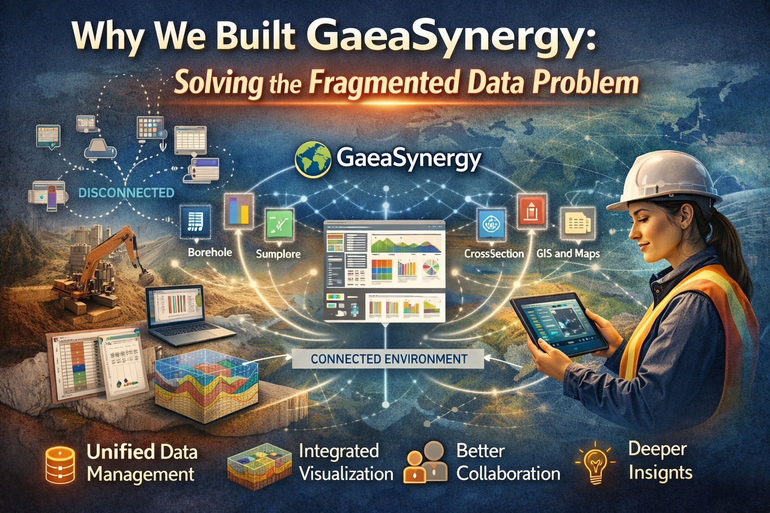
Fragmentation.
Data scattered across spreadsheets, disconnected software tools, legacy databases, PDFs, and field notes has long been the norm—not the exception. For many organizations, this fragmentation creates inefficiencies, introduces risk, and slows down decision-making.
At GAEA Technologies, we experienced this problem firsthand alongside our users. And it’s precisely why we built GaeaSynergy.
This is the story behind that decision—what we saw, what we learned, and how GaeaSynergy was designed to solve one of the most fundamental challenges in geoscience workflows.
The Problem: A Fragmented Data Landscape
Before the rise of integrated platforms, most geoscience workflows evolved organically. Teams adopted tools based on immediate needs:
- Spreadsheets for borehole logs and sample tracking
- CAD software for drafting cross-sections
- GIS platforms for mapping
- Separate databases for environmental data
- PDFs and reports stored in shared drives
- Field notes captured on paper or mobile devices
Individually, each tool served a purpose. But collectively, they created a fragmented ecosystem.
What Fragmentation Looks Like in Practice
Consider a typical project:
- Borehole data is logged in one system
- Laboratory results arrive in another format
- Maps are created in GIS software
- Cross-sections are drafted separately
- Reports are compiled manually
Now multiply that across dozens—or hundreds—of projects.
The result?
- Data duplication
- Version control issues
- Inconsistent formats
- Lost or inaccessible information
- Time-consuming manual processes
Fragmentation isn’t just inconvenient—it’s a structural problem that affects every stage of a project lifecycle.
The Hidden Costs of Disconnected Systems
While fragmented data might seem manageable on the surface, its true cost becomes clear over time.
1. Lost Productivity
Professionals spend countless hours:
- Searching for data
- Reformatting files
- Reconciling inconsistencies
- Re-entering information across systems
Time that should be spent analyzing data is instead spent managing it.
2. Increased Risk of Errors
When data exists in multiple places, inconsistencies are inevitable.
- Outdated datasets get used in reports
- Manual data entry introduces errors
- Misaligned versions lead to incorrect interpretations
In geoscience and engineering, these errors can have serious consequences.
3. Poor Collaboration
Fragmented systems make collaboration difficult:
- Teams work in silos
- Data is not easily shared
- Communication gaps emerge
This becomes especially problematic on large, multidisciplinary projects.
4. Limited Insight
When data is disconnected, it’s harder to see the bigger picture.
- Trends are missed
- Relationships between datasets remain hidden
- Decision-making is slowed
Fragmentation limits not just efficiency—but understanding.
The Turning Point: Recognizing the Need for Integration
Over the years, we saw a pattern emerge across organizations of all sizes.
Despite advances in software, the underlying problem remained the same:
Too many tools, not enough connection.
Our users weren’t asking for more features—they were asking for better integration.
They wanted:
- A single source of truth
- Seamless workflows from field to office
- Real-time access to project data
- Tools that worked together—not separately
This realization marked a turning point.
Rather than continuing to build standalone applications, we asked a different question:
What if everything lived in one connected environment?
The Vision Behind GaeaSynergy
GaeaSynergy was born from a simple but powerful idea:
Unify geoscience data, workflows, and teams into a single platform.
This wasn’t just about consolidating tools—it was about rethinking how geoscience work gets done.
Core Principles
From the beginning, GaeaSynergy was guided by several key principles:
1. Centralization
All project data—boreholes, samples, lab results, maps, documents—should exist in one place.
No duplication. No silos. No confusion.
2. Integration
Different data types should work together seamlessly.
- Geological data connects with environmental data
- Spatial data integrates with tabular data
- Visualizations update automatically as data changes
3. Accessibility
Users should be able to access data:
- From anywhere
- At any time
- Across devices
Whether in the office or in the field.
4. Usability
The platform should reflect real workflows—not force users to adapt to rigid systems.
5. Scalability
From small projects to enterprise-level deployments, the system should grow with the organization.
Building GaeaSynergy: From Concept to Platform
Turning this vision into reality required more than just software development—it required a deep understanding of geoscience workflows.
Step 1: Understanding the Workflow
We worked closely with:
- Geotechnical engineers
- Environmental consultants
- Hydrogeologists
- GIS specialists
To map out how data moves through a project—from collection to reporting.
Step 2: Designing the Data Model
At the heart of GaeaSynergy is a unified data model that connects:
- Boreholes and wells
- Sample stations and lab results
- Geological layers and stratigraphy
- Maps and spatial data
- Documents and reports
This structure allows data to flow naturally across the platform.
Step 3: Creating Integrated Tools
Instead of separate applications, GaeaSynergy provides:
- Interactive project dashboards
- Real-time data visualization
- Mapping and spatial analysis
- Cross-sections and 3D views
- Document management
- Reporting tools
All within a single environment.
Step 4: Enabling Real-Time Updates
One of the most powerful aspects of GaeaSynergy is its ability to update in real time.
When data changes:
- Visualizations update automatically
- Reports reflect the latest information
- Teams stay aligned
No more manual synchronization.
Key Features That Solve Fragmentation
GaeaSynergy isn’t just a platform—it’s a solution designed specifically to eliminate fragmentation.
Unified Dashboards
Project dashboards bring together all key data points in one place:
- Boreholes
- Cross-sections
- Sample data
- Lab results
- Documents
This provides an instant overview of project status.
Centralized Data Management
All data is stored in a single, structured system.
- No duplication
- No version conflicts
- No scattered files
Integrated Visualization
From maps to 3D models, visualizations are directly connected to the underlying data.
- Changes propagate automatically
- Insights become clearer
Collaboration Tools
Teams can work together seamlessly:
- Shared access to data
- Consistent information across users
- Reduced communication gaps
Scalable Architecture
Whether managing a single site or multiple projects globally, GaeaSynergy scales to meet the need.
Real-World Impact
The shift from fragmented systems to an integrated platform has a measurable impact.
Improved Efficiency
- Reduced time spent on data management
- Faster report generation
- Streamlined workflows
Better Data Quality
- Single source of truth
- Fewer errors
- Consistent datasets
Enhanced Collaboration
- Teams work from the same data
- Improved communication
- Faster decision-making
Deeper Insights
- Integrated data reveals patterns
- Visualization enhances understanding
- Better outcomes for projects
Why Fragmentation Still Exists—and Why It Matters
If fragmentation is such a clear problem, why does it persist?
Legacy Systems
Many organizations rely on systems that were implemented years—or decades—ago.
Incremental Tool Adoption
New tools are added over time without replacing old ones.
Data Silos
Different departments manage their own data independently.
Resistance to Change
Transitioning to a new system can be challenging.
Despite these challenges, the cost of doing nothing continues to grow.
The Future of Geoscience is Connected
As the industry evolves, the need for integrated systems will only increase.
Emerging trends include:
- Cloud-based platforms
- Real-time data collection
- AI-driven analysis
- Digital twins
All of these rely on connected, structured data.
Fragmentation is not compatible with the future.
GaeaSynergy’s Role in the Next Generation of Workflows
GaeaSynergy is designed not just for today—but for what comes next.
By providing a unified foundation, it enables:
- Integration with emerging technologies
- Scalable data infrastructure
- Continuous innovation
It transforms data from a challenge into an asset.
Conclusion
We didn’t build GaeaSynergy to add another tool to the ecosystem.
We built it to solve a fundamental problem.
Fragmented data limits what geoscientists and engineers can achieve.
By bringing data, workflows, and teams together into a single platform, GaeaSynergy unlocks new possibilities:
- Faster insights
- Better decisions
- More efficient projects
After decades of working with geoscience data, one thing is clear:
The future belongs to connected systems.
And GaeaSynergy is our answer to that future.