

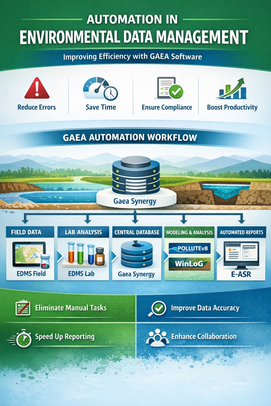
Environmental consulting projects depend on connected evidence. A soil description explains the setting of a sample; a laboratory result depends on the sample identity and method; a report conclusion depends on the quality and scope of the investigation. When these records are maintained separately, teams can spend considerable effort reconciling names, checking versions, and rebuilding context before they can interpret the findings.
An environmental consulting software workflow should preserve those relationships from collection through issue. WinLoG, EDMS, E-ASR, and GaeaSynergy contribute different capabilities to that process. This article follows a practical field-to-report workflow and identifies the decisions, checks, and handoffs that make it useful. The exact implementation depends on the products, modules, versions, templates, and exchange routes selected for the project.
Understand the role of each product
WinLoG supports structured borehole and well records, configurable log templates, and released Validation & QA/QC capabilities. EDMS organizes environmental sampling and analytical information, including laboratory results, quality review, criteria comparisons, and reporting. These roles address related information without making the products interchangeable.
GaeaSynergy provides a shared geoscience project environment with spatial and visualization capabilities; specialist workflows depend on the applicable licensed modules. E-ASR supports assessment-report preparation by merging responses to configured questions with report templates and conditional content. Confirm the supported handoff to each stage rather than assuming that every report component transfers automatically.
1. Define the project information before collection
Begin with the investigation objectives and the deliverables the team must produce. Identify the expected locations, sample types, laboratory information, logs, tables, figures, and report sections. Decide which records will be authoritative and who is responsible for reviewing them. A short project data plan can resolve ambiguities that would otherwise appear during import or report preparation.
Establish naming conventions before fieldwork. Project, borehole, monitoring-well, station, and sample identifiers should be distinguishable and traceable. A sample name that is unique within one field notebook may be ambiguous across several sampling rounds. Record the relationships between identifiers so later results can be associated with the correct place, interval, and event.
Agree units, coordinate references, date conventions, and the treatment of missing information. Keep a field for explanatory remarks where needed. A blank observation, an unavailable measurement, and a measured zero do not have the same meaning. Preserving those distinctions makes later review more reliable.
2. Build the borehole and well record in WinLoG
WinLoG’s depth-based records and templates can bring descriptions, samples, measurements, groundwater observations, and construction details together in a log. Its validation tools identify conditions requiring correction or review and can produce documented findings. The configured template determines how the relevant information is presented for the particular investigation.
For an environmental project, review the relationship between the observed stratigraphy, sampled intervals, and any monitoring-well installation. Check that identifiers, units, and depth references remain understandable to someone who did not attend the fieldwork. Preserve original observations and supporting documents when later corrections or interpretations are introduced.
Resolve review findings using evidence. An apparent interval overlap may be a transcription mistake or may reflect the way a sample was collected. The appropriate action is to investigate and document the decision, not simply alter the record until a warning disappears. Automated checks support the reviewer; they do not establish that every field observation is correct.
3. Connect sampling events and laboratory results in EDMS
EDMS supports the environmental data lifecycle, including scheduling, stations, samples, field observations, structured laboratory imports, QA/QC, and outputs. Its documented workflows retain information such as methods, qualifiers, and detection limits alongside results. That context matters when reviewing what a result represents and whether it can be used for the intended comparison.
Before production imports, agree the laboratory deliverable structure and test a representative file. Reconcile received samples against the submitted sample list, investigate unmatched identifiers, and retain the source laboratory documents. A successful import message does not prove that a result is linked to the correct sample or that every requested analysis has been received.
Keep revisions under control. If a laboratory issues an amended result, identify which earlier value it supersedes and which tables or figures may need regeneration. The project team should be able to explain the basis of the result used in an issued deliverable, even when later information becomes available.
4. Review results before drawing comparisons
EDMS can compare results with selected environmental criteria and retain relevant unit and detection-limit context. The responsible professional must establish which criteria apply to the project using the current official source. Software comparison supports that decision; it does not select the governing requirements on behalf of the consulting team.
As a project practice, record the chosen criteria set, its source, and the reason for its use. Check that the comparison is appropriate for the environmental medium, reported units, and measurement basis. Where a qualifier or reporting limit affects interpretation, retain that information in the review and in the output where necessary.
Distinguish data review from conclusions about site conditions. A highlighted value is a prompt to investigate its context, not a complete assessment. Review sample locations, methods, quality information, and investigation coverage together before deciding what the evidence supports. Avoid allowing an attractive summary table to conceal material gaps.
5. Use GaeaSynergy to review the wider site context
GaeaSynergy can organize project information with maps, surfaces, and three-dimensional views, while the available specialist records and outputs depend on the selected modules. This broader context helps a team examine where data was collected and how observations relate to site features and subsurface information.
Before interpreting a spatial view, confirm the reference systems and the identity of the displayed records. Two points that appear close together may come from different investigation phases or coordinate conventions. Check the underlying values and source references rather than relying only on the visual appearance of the map.
Keep observations distinguishable from derived presentations. A contour or interpreted boundary represents choices about the input data and the method used. Document those choices and review whether the sampling coverage supports the display. A smooth surface should not imply a level of certainty that the investigation did not establish.
6. Assemble the assessment report with E-ASR
E-ASR uses answers to predesigned questions to generate content within a configured report template. Responses can determine which paragraphs are included, allowing organizations to standardize recurring material while adapting the document to the project. GAEA describes applications including Phase I and Phase II assessments and other environmental reports, subject to the configured reporting requirements.
Prepare the questionnaire and template as controlled project tools. Test how missing answers, unusual conditions, and conflicting responses affect the generated text. Assign responsibility for maintaining standard language and approving revisions. A template that worked for one engagement may need adjustment for a different scope or reporting obligation.
Confirm how reviewed logs, analytical tables, maps, and other evidence enter the final report package. Where an attachment or output requires a separate preparation step, include that step in the procedure. The final reviewer should verify that narrative statements, figures, tables, and appendices all refer to the same approved information.
A hypothetical field-to-report example
Consider a consulting team investigating a property with several boreholes, monitoring wells, and two sampling rounds. The team begins with an agreed location register and identifiers for each event. It prepares the borehole and well records, reviews the logs, and records any unresolved questions before the analytical results are assembled for interpretation.
When laboratory files arrive, one sample identifier does not match the field register. The team checks the source records and resolves the discrepancy before associating the result with a location. It also receives an amended laboratory report and records which values changed. Those decisions become part of the project record rather than informal knowledge held by one person.
The reviewed information is then considered alongside site geography and subsurface observations. The report is assembled using the approved questionnaire and template, with checked outputs included through the agreed process. During final review, a corrected well detail requires an updated log and a check of the related narrative. The workflow succeeds because the team can identify the affected deliverables and explain the correction.
Define clear review gates and responsibilities
A connected process needs explicit points at which information is ready for the next task. These gates need not be complicated, but they should identify the reviewer and the evidence required. The following questions can form a practical starting checklist:
- Field review: Are location identities, observations, intervals, units, and supporting records complete enough for the next stage?
- Laboratory review: Are results associated with the correct samples, and are missing analyses, qualifiers, and revisions accounted for?
- Interpretation review: Are the selected comparisons and spatial presentations appropriate for the data and project purpose?
- Report review: Do the text, tables, figures, and appendices use consistent approved information?
- Issue control: Can the team identify the exact data and document versions supporting the delivered report?
Record who may correct a source record and who must reassess an affected output. This is especially important when one person prepares logs, another manages analytical data, and another writes the report. A clear correction path reduces the risk that one deliverable is updated while another retains an obsolete value.
Implement the workflow through a representative pilot
Test one bounded project before applying the process across a large portfolio. Include a normal record, an exception, a laboratory revision, and a representative report. Confirm the relevant licensing and supported exchange paths, and document any required configuration or manual handoffs. The pilot should test how the team works, not merely whether each application opens successfully.
Measure the complete effort from data preparation to accepted output, including review and rework. Record which steps become simpler and which require new training or setup. Define success in terms of traceable records and reliable deliverables as well as time. Use the findings to refine templates, instructions, and responsibilities before expanding the rollout.
To discuss a practical implementation, contact GAEA with your current field-to-report process, representative outputs, and the difficulties you want to address. A shared information structure, tested handoffs, and clear professional review responsibilities provide the foundation for a complete environmental consulting workflow.