


Discover how GAEA’s new Migration Center makes it easier to import government well records, reuse historical geological information, and integrate public subsurface data into WinLoG and GaeaSynergy projects.
Unlocking the value of government well databases
Government agencies have accumulated extensive collections of subsurface information through decades of water well drilling, groundwater investigations, and geological surveys.
These records often contain valuable information about soil and rock formations, groundwater conditions, drilling depths, and well construction.
For geotechnical engineers, environmental consultants, hydrogeologists, and geological professionals, this information can provide an important starting point for new investigations.
Until now, transferring government water well records into engineering software has often required considerable manual effort.
With the release of the new GAEA Migration Center, importing government well data into engineering projects becomes significantly easier.
The Migration Center provides a structured method for transferring supported government well records into GAEA’s project environment, reducing repetitive data entry and making existing geological information more accessible.
Rather than treating historical well information as an isolated reference, engineers can incorporate relevant records into their broader subsurface data management workflows.
Why government water well records are valuable
Before beginning a new subsurface investigation, engineers often want to understand the geological conditions surrounding a project site.
Government water well databases can provide useful preliminary information about:
- Regional soil and rock formations.
- Depth to bedrock.
- Sand and gravel deposits.
- Reported groundwater levels.
- Well construction and drilling depths.
- Variations in geological conditions across an investigation area.
For example, consider a proposed commercial development where an engineer needs to evaluate the anticipated depth to bedrock.
Nearby government well records may indicate relatively shallow limestone in one area and significantly deeper bedrock in another.
Although these records cannot replace site-specific drilling, they may help the engineer identify geological trends and refine the preliminary investigation plan.
Similarly, records describing sand and gravel aquifers may help an environmental consultant develop a better understanding of regional groundwater conditions.
The value of these records increases when they can be organized, reviewed, and compared with newly collected investigation data.
Introducing government well database importing
The GAEA Migration Center is designed to simplify the transfer of existing geological, geotechnical, and environmental information into GAEA software.
A key feature of the new release is support for importing records from government water well databases.
The import process helps users transfer information from supported government data sources into project records suitable for use with WinLoG and GaeaSynergy.
Depending on the available information in the source database, imported records can include well identification, geological descriptions, depth intervals, groundwater information, and other relevant well details.
Because government agencies use different database structures, the Migration Center uses source-specific import support to translate available data into the corresponding GAEA project fields.
This reduces the need to manually recreate individual well logs and provides a more consistent approach to incorporating historical subsurface information.
How the government well import process works
The Migration Center provides a structured workflow for converting government well records into usable engineering project information.
Step 1: Select a supported government database
Begin by selecting the appropriate government data source and the corresponding database or data file.
Government agencies may distribute well information in formats such as Microsoft Access databases, CSV files, or GIS datasets.
The supported import options determine how the original information is interpreted and transferred.
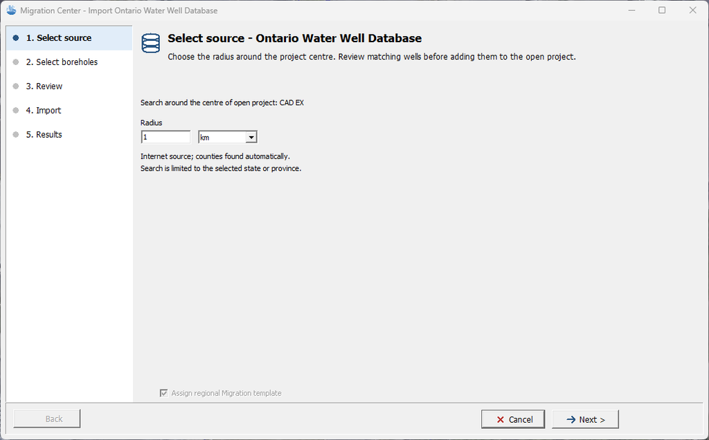
Step 2: Identify the wells to import
Government databases can contain many thousands of records, while a particular engineering project may require only a limited subset.

Selecting relevant wells helps keep project datasets manageable and ensures that imported information is appropriate for the investigation.
Where supported by the selected source and import workflow, users can identify records based on available geographic or well identification information.

Step 3: Import geological and well information
The Migration Center converts supported database fields into the corresponding GAEA project records.
Depending on the source, the transferred information may include geological layer descriptions, depth intervals, reported well depths, coordinates, and groundwater observations.
The conversion process helps preserve the relationship between geological descriptions and their associated depth measurements.
Step 4: Review imported information
After importing the records, engineers can review their completeness and suitability.
Historical government records may contain missing coordinates, incomplete descriptions, inconsistent units, or uncertain groundwater measurements.
These limitations originate in the source records and should be considered when interpreting the imported information.
GAEA’s Validation and QA/QC capabilities can provide additional assistance when reviewing applicable subsurface data.
Step 5: Use the records in engineering projects
Once imported, the well information can be managed alongside other project data within the GAEA software environment.
This makes historical records easier to reference when planning investigations, preparing borehole logs, or evaluating regional subsurface conditions.
The result is a more practical way to reuse geological information that has already been collected.
Ontario water well records: a practical example
Ontario maintains an extensive Water Well Information System (WWIS) containing records submitted by water well contractors.
The Ontario government’s open data program makes well information available through downloadable datasets.
Depending on the record, the information may include drilling depths, geological descriptions, reported groundwater conditions, and construction details.
Consider a hypothetical residential subdivision project in southern Ontario.
An engineering consultant is preparing a preliminary investigation plan and wants to understand the regional geological conditions.
Nearby historical water well records indicate varying thicknesses of glacial till, sand and gravel, and underlying bedrock.
Previously, the consultant might have needed to examine individual records or manually transfer selected information into borehole logging software.
Using the GAEA Migration Center’s supported government well import capability, the consultant can bring the relevant data into the engineering project environment.
The imported information can then be reviewed alongside new geotechnical boreholes and other investigation records.
This provides a more complete preliminary view of the surrounding geology while reducing the effort involved in reproducing historical data.
Government records remain supplementary information and must be interpreted with appropriate consideration of their age, accuracy, and original purpose.
Applications in geotechnical engineering
For geotechnical engineers, government well information is particularly useful during preliminary site assessment and investigation planning.
Potential applications include identifying regional geological sequences, evaluating variations in bedrock depth, and investigating the possible presence of granular deposits.
Where historical wells are distributed across a broad study area, they may provide useful background information beyond the immediate boundaries of a proposed development.
This information can help engineers determine where more detailed site-specific investigation is needed.
The Migration Center makes it easier to incorporate these historical records into the project’s information base rather than keeping them in separate files or manually prepared spreadsheets.
Applications in environmental and groundwater investigations
Environmental consultants and hydrogeologists may also benefit from government well database importing.
Historical records can help identify nearby water wells, potential aquifers, reported groundwater conditions, and geological units relevant to groundwater movement.
For example, during a Phase II environmental site assessment, surrounding well records may provide preliminary information about the regional groundwater setting.
Imported records can support early conceptual site model development and help guide subsequent data collection.
Similarly, hydrogeological investigations may benefit from access to existing well construction information and historical geological descriptions.
As with geotechnical investigations, the records must be evaluated for quality and suitability before they are used in technical conclusions.
Combining historical and new subsurface information
One of the most significant benefits of the Migration Center is the opportunity to use historical and newly collected subsurface information within a more consistent project framework.
A project might contain 15 recently drilled geotechnical boreholes and dozens of relevant government water well records.
The new geotechnical boreholes may provide detailed engineering descriptions, field testing results, and laboratory information.
The government records may provide broader geographic coverage and additional geological observations.
Used together, these information sources can help engineers identify regional trends, recognize potential geological variability, and improve preliminary interpretations.
However, the two sources should not be treated as equally reliable without considering their different collection methods and quality controls.
A government water well record collected decades ago may contain useful observations but may not meet current geotechnical logging standards.
The ability to preserve and identify source information is therefore an important part of responsible data management.
Data quality and validation remain essential
Importing information efficiently is only the first step.
Engineers must also understand the quality and limitations of the original records.
Typical issues in government well datasets include:
- Missing or approximate coordinates.
- Duplicate well identifiers.
- Incomplete geological descriptions.
- Gaps or overlaps in reported geological intervals.
- Inconsistent units.
- Missing groundwater measurements.
- Uncertain formation boundaries.
The Migration Center simplifies data transfer, while GAEA’s broader Validation and QA/QC functionality supports the goal of more consistent and reliable subsurface information.
Together, these capabilities provide a foundation for improving how existing records are incorporated into modern engineering workflows.
Importantly, a successful import should never be interpreted as confirmation that the original field observations are accurate.
Professional review remains essential.
Supporting government datasets from different regions
Government well information is available from many jurisdictions across Canada, the United States, and other countries.
For example, Ontario provides downloadable well record information, while the United States Geological Survey and individual state agencies maintain extensive groundwater datasets.
However, different government databases use different field names, geological classifications, coordinate systems, and data structures.
Consequently, the Migration Center’s import capabilities are specific to the sources and formats supported by the installed release.
Users should consult the Migration Center documentation for the current list of supported government databases and associated import requirements.
As GAEA expands its data migration capabilities, additional government data sources may be considered based on customer demand and the availability of suitable datasets.
More than government well data: a broader migration strategy
Government well database importing is part of the broader GAEA Migration Center initiative.
The Migration Center brings together data migration capabilities intended to help engineering organizations reuse information stored in different software systems and industry formats.
This includes migration workflows for supported legacy GAEA data, industry-standard exchange formats, and other established geological and geotechnical information sources.
The objective is to reduce the barriers associated with changing software systems, importing external records, and preserving historical investigation data.
For companies that have accumulated years of information in legacy software or government databases, this can represent a substantial improvement in how existing information is accessed and reused.
Instead of manually re-entering data or maintaining separate project archives, engineers can take a more systematic approach to importing records into the GAEA environment.
A practical step toward better subsurface data management
Subsurface investigations are expensive, and collecting new geological information requires substantial resources.
At the same time, useful information may already exist in government well databases, historical project archives, and older engineering software systems.
The challenge is making that information accessible and usable.
The new GAEA Migration Center helps bridge the gap between existing subsurface records and modern engineering projects.
By simplifying the transfer of government water well information into GAEA software, it helps engineers reduce repetitive data preparation, preserve historical information, and develop a more complete understanding of regional subsurface conditions.
For engineering and environmental organizations, the benefit is not simply faster data importing.
It is the ability to make better use of geological information that might otherwise remain difficult to access.
Get started with the GAEA Migration Center
The GAEA Migration Center is available as part of GAEA’s latest software development initiative.
To learn more about importing government well databases, supported data sources, and other migration capabilities, explore the following resources:
- GAEA Migration Center
- WinLoG Borehole and Well Logging Software
- GaeaSynergy Data Management
- GaeaSynergy Import and Export
Make existing subsurface information more accessible with GAEA’s new Migration Center.