

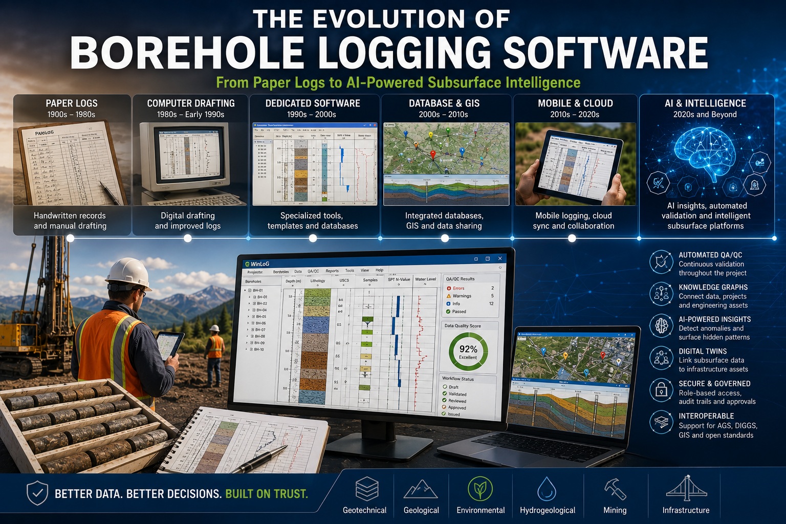
For more than a century, borehole logs have been one of the most important records produced during geological, geotechnical, hydrogeological, environmental, and mining investigations. They document the subsurface conditions encountered during drilling and provide the information engineers and geoscientists rely upon to design foundations, estimate mineral resources, assess environmental conditions, manage groundwater, and build critical infrastructure.
While the purpose of the borehole log has remained largely unchanged, the technology used to create, manage, and interpret these records has evolved dramatically. What began as handwritten field notes has progressed through CAD drafting, desktop logging software, relational databases, cloud collaboration, automated quality assurance, artificial intelligence, and intelligent knowledge platforms.
Today, borehole logging software is no longer simply a tool for producing attractive log sheets. It has become the central hub for managing, validating, analyzing, and sharing subsurface information throughout the lifecycle of engineering projects.
This article explores the evolution of borehole logging software, the technologies that have shaped its development, and the innovations that are defining the future of subsurface intelligence.
The Paper Era
For decades, borehole logs were created entirely by hand.
Field geologists recorded:
- Soil descriptions
- Rock descriptions
- Water levels
- Sample intervals
- Standard Penetration Test (SPT) results
- Core recovery
- Drilling observations
These handwritten notes were later drafted into formal borehole logs for engineering reports.
Although effective for their time, paper logs presented significant challenges:
- Difficult to search
- Difficult to archive
- Difficult to share
- Prone to transcription errors
- Impossible to automate
Every new project essentially started from scratch.
Historical knowledge remained trapped inside filing cabinets.
Computer Drafting
The arrival of personal computers introduced the first generation of digital borehole logs.
Many organizations used:
- CAD software
- Drawing programs
- Word processors
- Spreadsheet templates
The primary goal was producing cleaner reports.
However, the underlying data often remained disconnected.
Each borehole became an individual drawing rather than part of a searchable database.
Although report quality improved, data reuse remained limited.
Dedicated Borehole Logging Software
The next major advancement was the development of specialized borehole logging applications.
These systems introduced features such as:
- Borehole databases
- Automatic log generation
- Standardized symbols
- User-defined templates
- Sample management
- Laboratory integration
- Cross-sections
Instead of creating each log independently, organizations could now manage multiple projects within a single software platform.
This represented a major improvement in efficiency and consistency.
Relational Databases
As projects became larger, software evolved from individual files into relational database systems.
Separate tables stored:
- Projects
- Boreholes
- Samples
- Laboratory results
- Groundwater measurements
- Geological intervals
- Geotechnical testing
Relationships between datasets dramatically improved reporting and searching.
Engineers could now retrieve information across hundreds—or even thousands—of boreholes.
Geographic Information Systems (GIS)
The integration of GIS transformed borehole management.
Users could visualize:
- Borehole locations
- Geological maps
- Groundwater monitoring wells
- Environmental sampling
- Infrastructure corridors
Spatial analysis became significantly more powerful.
Instead of reviewing boreholes individually, engineers could evaluate regional geological patterns and site conditions.
Digital Data Exchange
As projects increasingly involved multiple organizations, standardized exchange formats became essential.
Formats such as:
- AGS
- DIGGS
- CSV
- XML
enabled information to move between consultants, laboratories, agencies, and owners.
Interoperability became a major focus of modern borehole software.
Rather than locking data into proprietary formats, successful platforms embraced open standards to improve collaboration and long-term accessibility.
Mobile Data Collection
The next evolution moved borehole logging into the field.
Tablets and rugged mobile devices allowed geologists to:
- Record lithology directly on site.
- Capture photographs.
- Enter groundwater observations.
- Record SPT blow counts.
- Synchronize information with project databases.
This reduced transcription errors while improving productivity.
Automated QA/QC
As project databases grew, manual quality reviews became increasingly difficult.
Modern software introduced automated validation.
Instead of checking information manually, systems could automatically identify:
- Missing data
- Invalid coordinates
- Overlapping intervals
- Incorrect SPT calculations
- Recovery greater than 100%
- Missing RQD
- Duplicate samples
- Laboratory inconsistencies
Automated QA/QC transformed borehole software from a passive repository into an active quality management system.
Workflow Management
Engineering organizations also required greater control over project reviews.
Modern software introduced governed workflows.
Typical lifecycle:
Draft
↓
Validated
↓
Reviewed
↓
Approved
↓
Issued
Each stage became traceable through:
- Audit trails
- Digital approvals
- Revision history
- User permissions
This improved accountability while supporting regulatory compliance.
Cloud Collaboration
Cloud technologies introduced new ways of working.
Distributed teams could:
- Share projects
- Synchronize databases
- Review logs remotely
- Collaborate in real time
- Access centralized information
Although desktop applications remain important—particularly for organizations with strict security requirements—cloud connectivity has become an increasingly valuable option for collaboration and data sharing.
Artificial Intelligence
Artificial intelligence represents the next major milestone.
Rather than replacing engineers, AI assists by:
- Identifying anomalies
- Summarizing reports
- Searching historical investigations
- Detecting unusual geological relationships
- Recommending validation checks
- Extracting information from legacy documents
AI dramatically reduces the time required to review large datasets while leaving final engineering decisions to qualified professionals.
Intelligent Databases
Modern platforms increasingly move beyond relational databases toward intelligent databases.
Instead of storing isolated records, they understand relationships between:
- Boreholes
- Projects
- Laboratory testing
- Groundwater monitoring
- Infrastructure assets
- Geological models
- Reports
- Regulatory requirements
This provides richer context for both engineers and AI systems.
Knowledge Graphs
Knowledge graphs represent another major advancement.
Rather than asking:
“Where is Borehole BH-17?”
Users can ask:
“Show every bridge project within 10 kilometres where soft clay exceeds five metres and groundwater has risen over the past decade.”
The system understands relationships rather than simple keywords.
Knowledge graphs transform databases into engineering knowledge systems.
Digital Twins
Transportation agencies, utilities, and mining companies increasingly use digital twins to manage physical assets.
Modern borehole software can contribute:
- Foundation conditions
- Geological models
- Groundwater data
- Laboratory testing
- Historical investigations
Subsurface information becomes directly connected to roads, bridges, tunnels, buildings, pipelines, and other infrastructure assets.
Continuous Validation
The latest systems validate information continuously rather than waiting until project completion.
Every time information changes, the software automatically checks:
- Completeness
- Consistency
- Engineering relationships
- Cross-dataset validation
- Regulatory requirements
Errors are detected immediately while they remain easy to correct.
Building Organizational Knowledge
Perhaps the greatest change is recognizing that borehole databases are no longer simply project tools.
They have become organizational knowledge repositories.
Every completed investigation contributes:
- Geological understanding
- Validation rules
- Laboratory trends
- Historical groundwater behaviour
- Engineering experience
- Lessons learned
Future projects benefit directly from decades of accumulated knowledge.
The Vision for WinLoG
WinLoG reflects this evolution by expanding beyond traditional borehole logging into a comprehensive subsurface data management platform. While it continues to provide professional log generation, cross-sections, and project management, its roadmap embraces the technologies shaping the future of engineering data.
Automated QA/QC, continuous validation, governed workflows, intelligent search, AI-assisted validation, knowledge graphs, and support for open standards such as AGS and DIGGS position WinLoG as more than a logging application. It becomes the central platform for managing geological, geotechnical, hydrogeological, environmental, and infrastructure information throughout the entire project lifecycle.
As organizations continue to digitize historical records and integrate GIS, digital twins, laboratory systems, and engineering workflows, WinLoG is designed to serve as the trusted source of subsurface knowledge that connects people, projects, and data.
Preparing for the Next Generation
Organizations can begin preparing for the future today by:
- Digitizing historical borehole records.
- Standardizing geological terminology.
- Implementing automated QA/QC.
- Adopting AGS and DIGGS exchange formats.
- Maintaining governed workflows.
- Preserving audit trails.
- Integrating GIS and laboratory systems.
- Building centralized borehole databases.
- Investing in structured, reusable engineering data.
These investments lay the groundwork for AI-assisted engineering and intelligent subsurface management.
Looking Ahead
The next decade will likely see borehole logging software become even more intelligent.
Future capabilities may include:
- AI-generated geological summaries.
- Predictive groundwater analysis.
- Automatic lithology classification from photographs.
- Intelligent report generation.
- Voice-assisted field logging.
- Real-time collaboration between field and office teams.
- Digital twin synchronization.
- Predictive maintenance for infrastructure based on subsurface conditions.
- Organization-wide knowledge discovery using AI and knowledge graphs.
The focus will shift from managing records to delivering engineering insight.
Conclusion
The evolution of borehole logging software mirrors the broader transformation of engineering itself. What began as handwritten field notes has become an interconnected digital ecosystem that supports geology, geotechnics, hydrogeology, environmental science, mining, and infrastructure engineering.
Today’s leading platforms do far more than create borehole logs. They validate information, manage workflows, connect historical knowledge, support regulatory compliance, integrate with GIS and digital twins, and increasingly assist engineers through artificial intelligence.
As organizations continue to embrace digital engineering, the future belongs to software that not only stores subsurface data but also understands it. By combining high-quality data, automated QA/QC, intelligent databases, knowledge graphs, and AI-assisted analysis, borehole logging software is evolving into the trusted subsurface intelligence platforms that will support better engineering decisions for decades to come.