

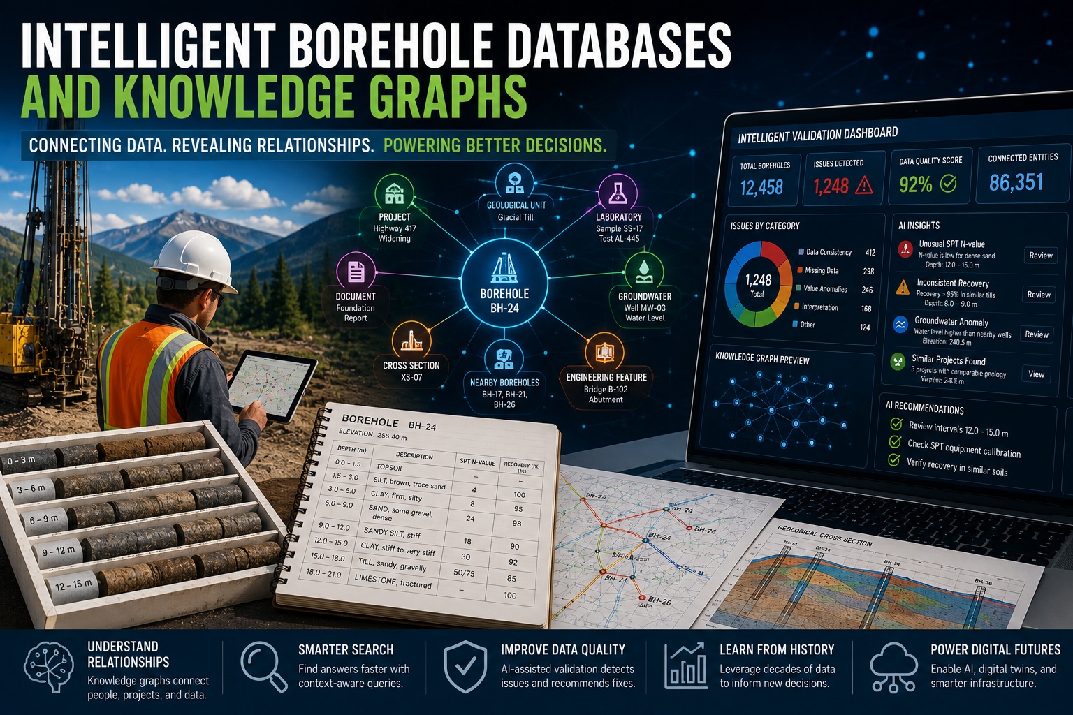
For decades, borehole databases have served as digital filing cabinets for geological, geotechnical, hydrogeological, and environmental information. They store borehole logs, laboratory results, groundwater measurements, sampling records, geological descriptions, and engineering observations in structured tables that can be searched and reported.
While this represented a major advancement over paper records, today’s engineering projects demand far more than data storage. Organizations need systems that understand relationships between information, connect historical investigations, support artificial intelligence, automate validation, and help engineers discover knowledge rather than simply retrieve records.
This is where intelligent borehole databases and knowledge graphs are transforming the future of subsurface data management.
Instead of viewing a borehole as an isolated record, an intelligent database recognizes that every borehole is connected to projects, geological units, laboratory samples, groundwater wells, engineering reports, geophysical surveys, infrastructure assets, historical investigations, regulatory requirements, and even neighboring boreholes. These relationships create a rich network of knowledge that engineers can explore to answer complex questions in seconds rather than days.
This article examines how intelligent borehole databases and knowledge graphs work, why they represent the next generation of geological data management, and how they will support AI-assisted engineering, digital twins, and smarter infrastructure decisions.
The Evolution of Borehole Databases
The first generation of borehole software focused on replacing paper logs.
Capabilities included:
- Borehole storage
- Log printing
- Sample records
- Basic reports
The second generation introduced relational databases with support for:
- Multiple projects
- Laboratory data
- Groundwater records
- GIS integration
- Digital reporting
- Cross-sections
Today’s systems are entering a third generation, where databases become intelligent rather than simply relational.
Instead of asking:
“Show me Borehole BH-17.”
Users can ask:
“Show all boreholes within 500 metres of this bridge where clay extends deeper than 10 metres, groundwater exceeds elevation 240 m, and historical reports identified settlement issues.”
The system understands both the data and the relationships between it.
What Is an Intelligent Borehole Database?
An intelligent borehole database stores traditional information while also understanding how different entities relate to one another.
Rather than treating each table independently, the database recognizes relationships between:
- Projects
- Boreholes
- Samples
- Laboratory tests
- Geological units
- Stratigraphy
- Groundwater wells
- Monitoring events
- Cross-sections
- Maps
- Documents
- Engineers
- Validation records
- Regulatory requirements
This allows users to navigate information naturally instead of manually joining dozens of tables.
Understanding Knowledge Graphs
A knowledge graph represents information as connected nodes and relationships.
For example:
Project A
contains
Borehole BH-12
which intersects
Glacial Till
which contains
Sample SS-17
which produced
Laboratory Result AL-445
which supports
Foundation Design Report
which references
Bridge Structure B-102
Rather than existing as isolated database records, each item becomes part of an interconnected knowledge network.
This structure mirrors how engineers naturally think about projects.
Why Relationships Matter
Traditional databases answer questions such as:
“What is the moisture content of Sample 17?”
Knowledge graphs answer much richer questions:
- Which laboratory tests support this design?
- Which reports reference this borehole?
- Which nearby projects encountered similar conditions?
- Which groundwater wells monitor the same aquifer?
- Which validation issues remain unresolved?
- Which historical investigations overlap this alignment?
These answers require understanding relationships—not just data.
Connecting Multiple Disciplines
Transportation, mining, environmental, and geotechnical projects involve numerous specialists.
An intelligent database can connect:
Geological Data
- Lithology
- Stratigraphy
- Rock descriptions
- Structures
Geotechnical Data
- SPT
- CPT
- Laboratory testing
- Foundation recommendations
Hydrogeological Data
- Water levels
- Hydraulic conductivity
- Pump tests
- Monitoring wells
Environmental Data
- Soil chemistry
- Groundwater chemistry
- VOC analyses
- Monitoring programs
Infrastructure Information
- Bridges
- Roads
- Utilities
- Tunnels
- Railways
Instead of maintaining disconnected datasets, the knowledge graph links them into a unified engineering knowledge base.
Supporting AI
Artificial intelligence performs best when relationships between data are well defined.
Knowledge graphs provide AI with valuable context.
For example, when reviewing a borehole, AI can determine:
- Nearby investigations
- Similar lithologies
- Historical groundwater conditions
- Laboratory trends
- Previous validation issues
- Construction history
- Engineering reports
Rather than analyzing isolated records, AI evaluates the complete engineering context.
Smarter Search
Traditional searches require users to know exactly what they are looking for.
Knowledge graphs enable semantic searches such as:
“Find bridge projects with soft clay beneath embankments.”
or
“Show boreholes that resemble this geological profile.”
or
“Locate all projects where groundwater exceeded design assumptions.”
The database understands the meaning of the request rather than matching keywords alone.
Automated Knowledge Discovery
One of the greatest advantages of knowledge graphs is discovering relationships engineers may not have considered.
Examples include:
- Similar geological formations across projects.
- Repeated construction issues.
- Common groundwater behaviour.
- Laboratory trends.
- Frequently occurring validation errors.
- Regional engineering characteristics.
These insights support continuous improvement across an organization.
Supporting Digital Twins
Transportation agencies increasingly develop digital twins representing infrastructure assets throughout their lifecycle.
Knowledge graphs connect borehole information directly to:
- Bridges
- Highways
- Utilities
- Retaining walls
- Tunnels
- Rail infrastructure
Selecting an asset within a digital twin could instantly reveal:
- Nearby boreholes
- Foundation conditions
- Laboratory testing
- Groundwater records
- Historical investigations
- Maintenance history
- Validation status
This creates a far richer operational picture than traditional document archives.
Improving Resource Estimation
Mining companies rely on multiple datasets during resource estimation.
Knowledge graphs connect:
- Drillholes
- Assays
- Density measurements
- Geological domains
- Structural interpretations
- Resource models
- QA/QC results
Instead of searching through separate databases, geologists can quickly trace how every assay, sample, and interpretation contributes to a resource estimate, improving transparency and auditability.
Environmental Applications
Environmental investigations often involve decades of historical information.
Knowledge graphs can connect:
- Previous Phase I and Phase II ESAs
- Monitoring wells
- Soil samples
- Groundwater chemistry
- Historical aerial photography
- Regulatory correspondence
- Contaminant plumes
- Site remediation activities
Engineers gain a comprehensive understanding of site history without manually searching hundreds of reports.
Governance and Traceability
Intelligent databases strengthen data governance by recording relationships between data and decisions.
For every borehole, organizations can determine:
- Who created it
- Who edited it
- Who approved it
- Which reports used it
- Which laboratory results support it
- Which validation rules were applied
- Which design decisions relied on it
This traceability improves accountability and supports regulatory compliance.
Integrating QA/QC
Knowledge graphs enhance automated validation because rules can span multiple datasets.
Examples include:
- Compare lithology with laboratory plasticity.
- Compare groundwater trends across nearby wells.
- Identify inconsistent geological contacts between adjacent boreholes.
- Verify that laboratory samples belong to valid intervals.
- Confirm foundation recommendations align with soil conditions.
Instead of validating isolated records, the system validates engineering knowledge.
Learning from Historical Projects
Organizations often possess tens of thousands of historical boreholes.
Knowledge graphs make this information reusable.
When starting a new project, engineers can immediately discover:
- Similar geology
- Comparable foundation designs
- Previous construction challenges
- Historical groundwater behaviour
- Nearby laboratory testing
- Existing monitoring wells
- Previous recommendations
This dramatically reduces duplicated work.
Intelligent Recommendations
Future borehole databases will not simply answer questions.
They will proactively recommend information.
Examples include:
“This project resembles three nearby highway investigations.”
“Historical groundwater exceeded current assumptions.”
“Laboratory testing is incomplete for similar soil conditions.”
“Previous bridge foundations encountered unexpected soft clay.”
These recommendations help engineers make more informed decisions while preserving professional oversight.
WinLoG’s Vision for Intelligent Borehole Databases
The long-term vision for WinLoG extends beyond managing borehole records to creating an intelligent subsurface knowledge platform. Traditional relational databases will continue to provide the structured foundation for storing boreholes, samples, laboratory results, groundwater records, and engineering observations, while intelligent relationship mapping adds a new layer of understanding.
In this vision, every borehole becomes part of a connected network that links projects, geological units, laboratory analyses, validation results, reports, infrastructure assets, maps, cross-sections, and historical investigations. AI-assisted tools can then navigate these relationships to answer complex engineering questions, identify similar projects, recommend relevant reports, summarize historical findings, and support decision-making with contextual information.
Combined with automated QA/QC, governed workflows, digital twins, AGS and DIGGS interoperability, and AI-assisted validation, WinLoG has the potential to evolve from a borehole logging application into a comprehensive subsurface intelligence platform that preserves organizational knowledge and makes it immediately accessible to engineers and geoscientists.
Challenges and Considerations
While the benefits are significant, implementing intelligent borehole databases requires careful planning.
Key considerations include:
- Standardized geological terminology.
- Consistent coding systems.
- High-quality historical data.
- Strong data governance.
- Secure access controls.
- Scalable database architecture.
- Integration with GIS, BIM, and digital twin platforms.
- Explainable AI and transparent recommendations.
Organizations that invest in data quality today will gain the greatest value from intelligent knowledge systems tomorrow.
Preparing for the Future
Engineering organizations can begin preparing by:
- Digitizing historical borehole records.
- Implementing automated QA/QC.
- Standardizing geological and laboratory terminology.
- Adopting AGS and DIGGS where appropriate.
- Preserving audit trails and revision histories.
- Linking reports, maps, and borehole records.
- Establishing data governance policies.
- Investing in structured, searchable databases.
These steps create the foundation required for intelligent databases and AI-assisted engineering.
Conclusion
The future of borehole data management is not simply about storing more information—it is about understanding how that information is connected. Intelligent borehole databases and knowledge graphs transform isolated records into an interconnected network of engineering knowledge that can be searched, analyzed, validated, and reused across projects and disciplines.
By combining structured databases, automated QA/QC, AI-assisted analysis, data governance, and knowledge graphs, organizations can unlock the full value of decades of geological, geotechnical, hydrogeological, and environmental information. Engineers spend less time searching for data, more time interpreting it, and gain greater confidence that every decision is supported by complete, traceable, and context-rich information.
As infrastructure owners, mining companies, environmental consultants, and engineering firms continue their digital transformation, intelligent borehole databases will become a cornerstone of modern subsurface intelligence—connecting people, projects, and knowledge in ways that traditional databases never could.