
Environmental due diligence is a critical component of property transactions, redevelopment projects, and regulatory compliance. Among the most widely recognized forms of environmental due diligence is the Phase I Environmental Site Assessment (ESA). Conducted according to standards such as ASTM E1527, Phase I ESAs evaluate potential environmental liabilities associated with a property by reviewing historical records, conducting site inspections, and interviewing knowledgeable individuals.
Traditionally, Phase I ESAs have been labor-intensive processes involving manual document review, handwritten field notes, extensive report writing, and coordination among multiple professionals. However, advances in digital tools, environmental data platforms, geographic information systems (GIS), and automated reporting systems are transforming the way environmental consultants conduct these assessments.
Automation does not replace professional judgment—rather, it enhances efficiency, consistency, and data integration. By leveraging automation, environmental consulting firms can streamline workflows, reduce reporting time, improve data accuracy, and better manage large volumes of environmental information.
This article explores how automation is reshaping Phase I Environmental Site Assessments, the tools enabling digital workflows, and best practices for implementing automated ESA processes.
Understanding the Phase I Environmental Site Assessment Process
Before discussing automation, it is important to understand the typical workflow of a Phase I ESA. The assessment generally includes four major components:
Records Review
Environmental professionals review historical and regulatory records to identify potential contamination sources. This may include:
- Historical aerial photographs
- Fire insurance maps (Sanborn maps)
- Topographic maps
- City directories
- Environmental regulatory databases
- Spill records and permits
The objective is to identify Recognized Environmental Conditions (RECs) that may indicate contamination risks.
Site Reconnaissance
A physical inspection of the property is conducted to observe environmental conditions such as:
- Evidence of chemical storage or spills
- Underground or aboveground storage tanks
- Waste handling practices
- Distressed vegetation
- Stained soils or unusual odors
Inspectors typically document observations with photographs, field notes, and GPS coordinates.
Interviews
Consultants interview individuals familiar with the property, including:
- Current or former property owners
- Site managers
- Local government officials
Interviews provide insight into historical land use and potential contamination events.
Report Preparation
The final Phase I ESA report summarizes findings, identifies RECs, and provides conclusions regarding environmental liability. Reports must follow specific formats to comply with regulatory and ASTM standards.
While this workflow is well established, many steps traditionally rely on manual processes. Automation introduces opportunities to improve efficiency across every stage.
Why Automate Phase I Environmental Site Assessments?
Environmental consulting firms face increasing pressure to deliver faster assessments without compromising quality. Automation helps address several key challenges.
Increasing Data Volume
Modern environmental assessments rely on large amounts of data, including:
- Environmental databases
- Satellite imagery
- GIS datasets
- Historical land-use records
Automated data integration tools can rapidly analyze and organize this information.
Improving Consistency
Manual reporting processes can lead to inconsistencies between assessments. Automated templates and standardized workflows ensure reports follow consistent formats and terminology.
Reducing Report Preparation Time
Environmental consultants often spend significant time formatting reports and compiling data. Automated reporting systems can generate structured reports directly from field data.
Enhancing Data Accuracy
Digital tools reduce transcription errors by capturing data directly in electronic formats rather than transferring handwritten notes into reports.
Supporting Remote Collaboration
Automation allows environmental professionals to collaborate across locations using cloud-based platforms.
Digital Tools Transforming Phase I ESA Workflows
Several categories of digital tools are enabling automation in environmental site assessments.
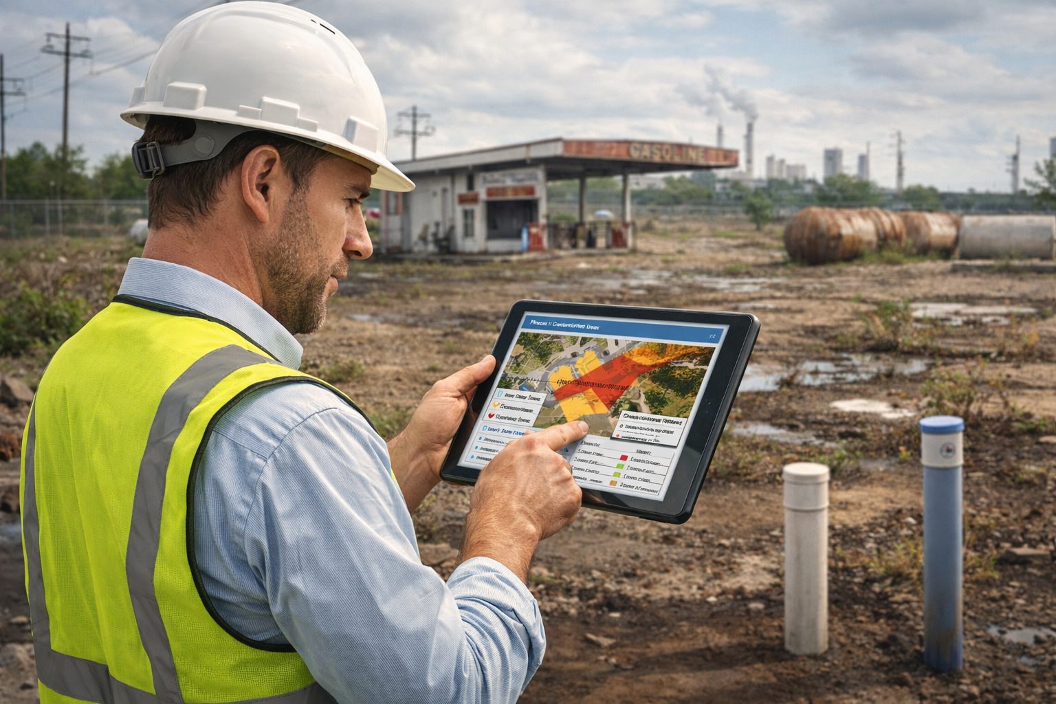
Mobile Field Data Collection Tools
Mobile devices such as tablets and smartphones are increasingly used for site inspections. Field data collection applications allow consultants to document observations in real time.
Typical features include:
- Digital inspection checklists
- GPS-enabled photo capture
- Voice-to-text note entry
- Automatic timestamping
- Integration with GIS maps
Using mobile tools, environmental professionals can capture detailed information during site inspections without relying on handwritten notes.
Field data is uploaded directly to centralized databases, eliminating the need for manual data entry.
Geographic Information Systems (GIS)
GIS technology plays a major role in environmental due diligence. Automated GIS workflows allow consultants to analyze spatial data related to environmental risks.
GIS platforms can integrate data such as:
- Environmental regulatory databases
- Contaminated site inventories
- Land-use zoning maps
- Groundwater protection areas
- Historical aerial imagery
Automated spatial analysis can identify potential contamination sources near a property, such as industrial facilities, gas stations, or hazardous waste sites.
GIS tools also support visualization of environmental features that may influence contamination risks.
Historical Data Analysis Tools
Identifying past land uses is a critical component of Phase I ESAs. Historically, this required manual review of paper records and archival materials.
Modern tools now automate the retrieval and analysis of historical data.
These tools may include:
- Digital aerial photograph databases
- Automated map georeferencing systems
- Historical document scanning and indexing
- Machine learning tools that identify land-use patterns
By automating historical research, consultants can rapidly assess decades of land-use history.
Environmental Database Integration
Environmental regulatory databases provide essential information about contamination risks.
Examples include databases containing:
- Hazardous waste sites
- Underground storage tank locations
- Spill incidents
- Industrial permits
Automated data integration tools can combine information from multiple regulatory databases and present results within a single interface.
This improves efficiency and reduces the risk of overlooking important records.
Automated Report Generation
Report preparation is often the most time-consuming step in Phase I ESA workflows. Automated reporting tools dramatically reduce the time required to produce professional reports.
These systems typically include:
- Predefined report templates
- Automated insertion of site data
- Integrated photo management
- Dynamic tables and figures
- Automatic generation of regulatory summaries
Because field data is already stored in digital formats, automated systems can generate reports directly from collected information.
Benefits of Automation in Environmental Consulting
The adoption of automated workflows offers numerous advantages for environmental consulting firms.
Faster Project Turnaround
Automation significantly reduces the time required to complete assessments. Tasks that once required hours of manual work can now be completed in minutes.
Faster turnaround allows consulting firms to handle larger project volumes and meet tight transaction timelines.
Improved Data Quality
Digital data capture minimizes errors associated with manual transcription and inconsistent record keeping.
Standardized forms ensure that important observations are not overlooked during site inspections.
Enhanced Collaboration
Cloud-based systems allow environmental professionals to share data instantly with colleagues and clients.
Team members can review site information, add comments, and update reports in real time.
Better Risk Identification
Automated spatial analysis and integrated databases improve the identification of environmental risks.
Consultants can evaluate surrounding land uses, historical activities, and regulatory records more comprehensively than with manual processes.
Reduced Administrative Work
Automation allows environmental professionals to focus on analysis and interpretation rather than administrative tasks.
Time previously spent formatting reports or organizing documents can instead be devoted to evaluating environmental risks.
Best Practices for Implementing Automated Phase I ESA Workflows
While automation offers significant benefits, successful implementation requires careful planning. The following best practices can help environmental consulting firms adopt automated workflows effectively.
Standardize Data Collection Procedures
Develop standardized digital forms for site inspections, interviews, and document reviews. Standardization ensures that data collected in the field aligns with reporting requirements.
Checklists should reflect regulatory standards and ASTM guidelines.
Integrate GIS Early in the Workflow
GIS should be incorporated early in the assessment process to support spatial analysis of environmental risks.
Automated GIS workflows can generate site maps, identify nearby contamination sources, and provide context for environmental conditions.
Maintain Centralized Data Management
All project data should be stored within centralized databases or cloud platforms.
Centralized systems ensure that:
- Field data is accessible to all team members
- Historical project records are preserved
- Data can be reused for future assessments
Proper data management also improves traceability and quality assurance.
Implement Quality Control Processes
Automation does not eliminate the need for professional oversight.
Quality control procedures should include:
- Peer review of reports
- Validation of automated data sources
- Verification of GIS analysis results
Professional judgment remains essential in interpreting environmental risks.
Ensure Regulatory Compliance
Automated systems must align with regulatory and ASTM standards governing Phase I ESAs.
Templates and workflows should incorporate required report sections such as:
- Site description
- Records review
- Site reconnaissance
- Interviews
- Findings and conclusions
Consultants should regularly update systems to reflect changes in regulatory requirements.
Emerging Technologies in Environmental Site Assessments
Automation continues to evolve as new technologies become available. Several emerging innovations may further transform environmental consulting workflows.
Artificial Intelligence and Machine Learning
AI technologies can analyze large environmental datasets to identify patterns and anomalies.
Potential applications include:
- Automated classification of historical aerial imagery
- Detection of industrial land uses
- Predictive analysis of contamination risks
AI tools may eventually assist consultants in identifying potential environmental concerns earlier in the assessment process.
Drone-Based Site Inspections
Unmanned aerial vehicles (UAVs) are increasingly used for environmental site inspections.
Drones can capture high-resolution aerial imagery and identify environmental features such as:
- Surface contamination
- Waste storage areas
- Drainage patterns
- Infrastructure conditions
Drone imagery can be integrated into GIS platforms and automated reporting systems.
Digital Twin Environmental Models
Digital twin technologies allow consultants to create dynamic virtual models of environmental systems.
These models integrate data from multiple sources, including:
- Geological data
- Groundwater models
- Environmental monitoring systems
Digital twins may enable more comprehensive environmental analysis and risk assessment.
Challenges and Considerations
Despite the advantages of automation, several challenges must be addressed.
Data Quality and Reliability
Automated systems depend on accurate data sources. Consultants must verify the reliability of environmental databases and historical records.
Training and Adoption
Environmental professionals must be trained to use new digital tools effectively.
Technology Integration
Integrating multiple software platforms can be complex. Successful implementation requires careful system design.
Maintaining Professional Judgment
Automation should support—not replace—professional expertise. Environmental consultants must interpret automated results within the context of site conditions.
The Future of Automated Environmental Due Diligence
The environmental consulting industry is rapidly embracing digital transformation. Automated Phase I Environmental Site Assessments represent an important step toward more efficient and data-driven environmental decision-making.
Future workflows may integrate multiple technologies, including:
- Cloud-based environmental data platforms
- AI-driven environmental risk analysis
- Real-time monitoring systems
- Advanced geospatial visualization tools
As environmental regulations evolve and development pressures increase, automation will play a critical role in ensuring that environmental due diligence remains both efficient and scientifically robust.
Conclusion
Automation is reshaping the way environmental professionals conduct Phase I Environmental Site Assessments. By integrating digital tools such as mobile field applications, GIS platforms, automated reporting systems, and environmental databases, consultants can significantly improve efficiency, data quality, and project turnaround times.
However, successful implementation requires careful planning, standardized workflows, and strong quality control processes. Automation should enhance—not replace—the expertise and professional judgment of environmental consultants.
As technology continues to evolve, automated environmental assessment tools will become increasingly sophisticated, enabling faster and more comprehensive evaluations of environmental risks. Consulting firms that adopt these technologies will be better positioned to deliver high-quality environmental due diligence services in an increasingly complex regulatory landscape.
Learn more about our Environmental Site Assessment Solutions
Related Articles
- Environmental Site Assessment Automation: Transforming Phase I and Phase II Environmental Reporting
- Automating Phase II Environmental Site Assessment Reporting
- How Automated Environmental Reporting Reduces Consulting Costs
- Digital Workflows for Environmental Due Diligence Investigations
- The Role of Data Automation in Modern Environmental Consulting
- Automating Environmental Compliance Reporting for Regulatory Submissions
- Meeting ASTM Standards with Automated Phase I ESA Reporting
- Automated Environmental Reporting for Brownfield Redevelopment Projects
- Cloud-Based Platforms for Environmental Investigation Data
- The Future of Automated Environmental Site Assessments
- An Overview of Phase I Environmental Site Assessments and How to Automate the Process
- Efficiency at Your Fingertips: Merging Questionnaire Data into Professional Reports with E-ASR
- Automating Environmental Excellence: Reporting with GAEA Technologies E-ASR
- Efficiency Redefined: Automating Environmental Reporting with E-ASR
- Streamlining Site Assessments: How Well Log Software Accelerates Contamination Reporting
- Reducing MTTR By 40%: The Power Of Automated Report Generation
- Why Automated Environmental Reporting Is the Game Changer Your Business Needs
External References
- ASTM Standard Practice for Environmental Site Assessments: Phase I Environmental Site Assessment Process
- US EPA Standards and Practices for All Appropriate Inquiries
- CSA Z768 — Phase I Environmental Site Assessment
- CSA Z769 — Phase II Environmental Site Assessment
- BS 10175 — Investigation of Potentially Contaminated Sites
- Australian National Environment Protection Measure (NEPM)