

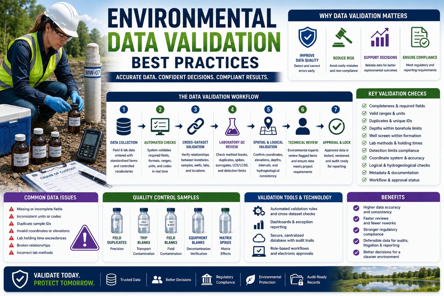
How to Build Accurate, Defensible, and Audit-Ready Environmental Databases
Environmental investigations generate enormous volumes of information. A single project may include borehole logs, groundwater monitoring data, laboratory analytical results, soil classifications, monitoring well construction details, field observations, GPS coordinates, photographs, chain-of-custody records, and regulatory reporting. Across large organizations, these records quickly grow into millions of individual data points collected over many years.
The value of this information depends entirely on its quality.
An environmental database containing incomplete, inconsistent, or inaccurate information can lead to incorrect risk assessments, flawed remediation strategies, regulatory non-compliance, project delays, and expensive rework. Even worse, poor-quality environmental data can compromise public health decisions, affect property transactions, and become a source of legal disputes.
This is why data validation has become one of the most important components of modern environmental data management. Effective validation goes far beyond checking whether required fields have been completed. It verifies logical consistency, relationships between datasets, spatial accuracy, laboratory quality, workflow compliance, and long-term traceability.
Modern environmental software increasingly automates much of this process through intelligent validation engines, cross-dataset comparisons, audit trails, and workflow controls. However, technology alone is not enough. Successful validation combines automated rules with expert review, standardized procedures, and robust data governance.
This article explores best practices for validating environmental data and explains how organizations can improve data quality while reducing regulatory, operational, and legal risk.
Why Environmental Data Validation Matters
Environmental data supports critical decisions involving:
- Contaminated site assessments
- Groundwater investigations
- Environmental remediation
- Landfill monitoring
- Industrial compliance
- Brownfield redevelopment
- Hydrogeological studies
- Environmental impact assessments
Errors within these datasets can influence:
- Risk assessments
- Contaminant plume interpretation
- Regulatory submissions
- Cleanup objectives
- Long-term monitoring programs
Validation helps ensure that decisions are based on accurate and reliable information.
Validation Is More Than Error Checking
Many organizations view validation as simply identifying missing values.
Modern environmental validation is much broader.
Effective validation evaluates:
- Completeness
- Logical consistency
- Cross-dataset relationships
- Laboratory quality
- Spatial accuracy
- Regulatory compliance
- Workflow integrity
- Historical traceability
Each contributes to overall confidence in the final dataset.
Begin with Standardized Data Collection
Validation starts before any information enters the database.
Standardized data collection significantly reduces downstream errors.
Organizations should standardize:
- Field forms
- Coding systems
- Sample naming conventions
- Coordinate systems
- Units of measurement
- Laboratory identifiers
Consistency at the source simplifies every subsequent validation step.
Validate Data at Entry
The most effective time to detect errors is immediately after they occur.
Real-time validation prevents invalid information from entering the database.
Examples include:
- Mandatory field verification
- Numeric range checking
- Date validation
- Duplicate identifiers
- Coordinate format verification
- Unit consistency
Immediate feedback reduces costly corrections later.
Validate Completeness
Environmental records should be evaluated for missing information.
Examples include:
Borehole Records
Required fields may include:
- Borehole ID
- Coordinates
- Elevation
- Final depth
- Drilling method
Groundwater Monitoring
Required information includes:
- Well ID
- Water level
- Sampling date
- Sampler
- Field parameters
Laboratory Results
Validation should verify:
- Sample ID
- Analytical method
- Detection limit
- Reporting units
- Laboratory identifier
Completeness checks prevent gaps in regulatory reporting.
Cross-Dataset Validation
Many environmental errors are only detected by comparing related datasets.
Cross-dataset validation is therefore one of the most powerful QA/QC techniques.
Borehole vs Sampling
Verify:
- Sample depths fall within borehole limits.
- Sample intervals do not overlap improperly.
- Borehole IDs match.
Well Construction vs Groundwater Data
Confirm:
- Water levels are physically possible.
- Screen intervals correspond to sampling depths.
- Monitoring data references valid wells.
Laboratory Results vs Sample Records
Ensure:
- Sample IDs exist.
- Collection dates match.
- Requested analyses were completed.
Coordinates vs GIS
Confirm:
- Locations fall within project boundaries.
- Coordinate systems are correct.
- Duplicate locations are investigated.
Cross-dataset validation detects issues that isolated field checks often miss.
Laboratory Data Validation
Laboratory data represents a significant portion of most environmental databases.
Validation should evaluate both analytical quality and data integrity.
Verify Analytical Methods
Ensure laboratory methods match project requirements.
Examples include:
- VOC analysis
- Metals
- PAHs
- Petroleum hydrocarbons
- PFAS
- Nutrients
Incorrect methods may invalidate results.
Review QA/QC Samples
Evaluate:
- Method blanks
- Laboratory duplicates
- Matrix spikes
- Surrogate recoveries
- Laboratory control samples
These results provide confidence in analytical performance.
Verify Detection Limits
Detection limits should meet project objectives.
Values above required reporting limits may not satisfy regulatory requirements.
Spatial Validation
Environmental investigations depend heavily on accurate location information.
Spatial validation should verify:
- Coordinate system
- Datum
- Elevation reference
- GIS compatibility
- Survey precision
Incorrect coordinates can dramatically alter contaminant plume interpretation and groundwater modelling.
Logical Validation Rules
Many environmental relationships can be evaluated automatically.
Examples include:
| Validation Rule | Example |
|---|---|
| Sample depth ≤ borehole depth | Required |
| Recovery ≤ 100% | Required |
| RQD ≤ Recovery | Required |
| Well screen within borehole | Required |
| Groundwater elevation ≤ casing elevation | Required |
| Sample date ≥ drilling completion | Required |
These rules improve consistency while reducing manual review.
Statistical Validation
Not every unusual value is incorrect.
However, statistical analysis helps identify anomalies requiring investigation.
Examples include:
- Outlier concentrations
- Unexpected groundwater elevations
- Sudden contaminant spikes
- Repeated identical measurements
Statistical validation should flag—not automatically reject—potential anomalies.
Expert review remains essential.
Workflow Validation
Environmental quality depends not only on data values but also on the processes used to manage them.
Workflow validation confirms that required review procedures have occurred.
Examples include:
- Validation completed
- Technical review completed
- Approval recorded
- Audit trail maintained
Incomplete workflows may compromise regulatory compliance.
Audit Trails
Every environmental database should maintain complete audit records.
Audit trails should document:
- Record creation
- Modifications
- Validation
- Review
- Approval
- Revisions
Each entry should record:
- User
- Date
- Time
- Previous value
- New value
- Reason for change
Audit trails support transparency and legal defensibility.
Metadata Validation
Metadata often receives less attention than analytical results but is equally important.
Validation should verify:
- Sampling methods
- Calibration records
- Weather conditions
- Preservation methods
- Laboratory methods
- Coordinate systems
- Equipment identifiers
Without metadata, environmental results may lose important context.
Automated Rule Engines
Modern environmental databases increasingly incorporate automated validation engines.
Examples include:
Domain Validation
Verify acceptable values.
Range Validation
Confirm realistic numeric values.
Cross-Dataset Validation
Compare related datasets.
Completeness Validation
Identify missing information.
AI-Assisted Validation
Detect unusual relationships using historical project data.
Automated rule engines dramatically reduce manual review effort.
Human Review Remains Essential
Automation cannot replace professional judgment.
Experienced reviewers evaluate:
- Geological interpretation
- Hydrogeological consistency
- Laboratory anomalies
- Regulatory implications
- Project context
The strongest QA/QC programs combine automated validation with expert review.
Data Governance
Validation depends upon effective governance.
Organizations should define:
- Data ownership
- User permissions
- Approval authority
- Revision procedures
- Retention policies
- Coding standards
Governance ensures consistency across projects and personnel.
Common Validation Mistakes
Frequently observed issues include:
- Missing metadata
- Duplicate sample IDs
- Incorrect coordinates
- Mixed units
- Invalid laboratory methods
- Holding time exceedances
- Broken relationships
- Inconsistent coding
- Missing approvals
Most can be prevented through automated validation and standardized workflows.
Preparing for Regulatory Audits
Regulators increasingly expect organizations to demonstrate:
- Documented QA/QC procedures
- Validation evidence
- Audit trails
- Complete metadata
- Workflow records
- Chain-of-custody documentation
Organizations should routinely review validation reports before submitting environmental data.
Emerging Technologies
Environmental validation continues to evolve rapidly.
Emerging technologies include:
- Artificial intelligence
- Machine learning
- Automated anomaly detection
- Mobile field validation
- Cloud-based databases
- GIS integration
- Digital signatures
- Electronic approvals
- Real-time dashboards
These technologies improve both efficiency and consistency.
Best Practices Checklist
Successful environmental data validation programs typically include:
✓ Standardized field procedures
✓ Controlled vocabularies
✓ Real-time data entry validation
✓ Cross-dataset validation
✓ Laboratory QA/QC review
✓ Statistical anomaly detection
✓ GIS validation
✓ Automated rule engines
✓ Independent technical review
✓ Audit trails
✓ Version control
✓ Role-based approvals
✓ Complete metadata
✓ Structured environmental databases
Following these practices significantly improves data quality while reducing project risk.
The Role of Integrated Environmental Data Management Systems
As environmental projects become increasingly complex, spreadsheets and disconnected databases are no longer sufficient for managing high-quality environmental information. Modern environmental data management systems integrate borehole logs, monitoring wells, laboratory imports, GIS mapping, field observations, validation engines, reporting tools, workflow management, and audit trails within a single platform.
An integrated system allows organizations to validate data automatically as it is collected, identify inconsistencies across related datasets, track revisions, and generate regulatory reports from a trusted source of information. This not only reduces manual effort but also improves consistency across projects, offices, and field teams.
Organizations that invest in integrated environmental databases are better positioned to support digital transformation, AI-assisted analytics, long-term monitoring programs, and evolving regulatory requirements.
Conclusion
Environmental data validation is far more than a technical exercise—it is a cornerstone of sound environmental management, regulatory compliance, and defensible decision-making. By validating completeness, logical consistency, laboratory quality, spatial accuracy, workflow integrity, and metadata, organizations can significantly reduce errors while improving confidence in every environmental assessment and monitoring program. The most effective QA/QC strategies combine standardized procedures, automated validation engines, cross-dataset comparisons, audit trails, and experienced technical review. As environmental investigations continue to generate larger and more complex datasets, organizations that implement comprehensive validation practices will be better equipped to deliver accurate, reliable, and audit-ready information that supports better engineering decisions, environmental protection, and long-term project success.
How to Build Accurate, Defensible, and Audit-Ready Environmental Databases
Environmental investigations generate enormous volumes of information. A single project may include borehole logs, groundwater monitoring data, laboratory analytical results, soil classifications, monitoring well construction details, field observations, GPS coordinates, photographs, chain-of-custody records, and regulatory reporting. Across large organizations, these records quickly grow into millions of individual data points collected over many years.
The value of this information depends entirely on its quality.
An environmental database containing incomplete, inconsistent, or inaccurate information can lead to incorrect risk assessments, flawed remediation strategies, regulatory non-compliance, project delays, and expensive rework. Even worse, poor-quality environmental data can compromise public health decisions, affect property transactions, and become a source of legal disputes.
This is why data validation has become one of the most important components of modern environmental data management. Effective validation goes far beyond checking whether required fields have been completed. It verifies logical consistency, relationships between datasets, spatial accuracy, laboratory quality, workflow compliance, and long-term traceability.
Modern environmental software increasingly automates much of this process through intelligent validation engines, cross-dataset comparisons, audit trails, and workflow controls. However, technology alone is not enough. Successful validation combines automated rules with expert review, standardized procedures, and robust data governance.
This article explores best practices for validating environmental data and explains how organizations can improve data quality while reducing regulatory, operational, and legal risk.
Why Environmental Data Validation Matters
Environmental data supports critical decisions involving:
- Contaminated site assessments
- Groundwater investigations
- Environmental remediation
- Landfill monitoring
- Industrial compliance
- Brownfield redevelopment
- Hydrogeological studies
- Environmental impact assessments
Errors within these datasets can influence:
- Risk assessments
- Contaminant plume interpretation
- Regulatory submissions
- Cleanup objectives
- Long-term monitoring programs
Validation helps ensure that decisions are based on accurate and reliable information.
Validation Is More Than Error Checking
Many organizations view validation as simply identifying missing values.
Modern environmental validation is much broader.
Effective validation evaluates:
- Completeness
- Logical consistency
- Cross-dataset relationships
- Laboratory quality
- Spatial accuracy
- Regulatory compliance
- Workflow integrity
- Historical traceability
Each contributes to overall confidence in the final dataset.
Begin with Standardized Data Collection
Validation starts before any information enters the database.
Standardized data collection significantly reduces downstream errors.
Organizations should standardize:
- Field forms
- Coding systems
- Sample naming conventions
- Coordinate systems
- Units of measurement
- Laboratory identifiers
Consistency at the source simplifies every subsequent validation step.
Validate Data at Entry
The most effective time to detect errors is immediately after they occur.
Real-time validation prevents invalid information from entering the database.
Examples include:
- Mandatory field verification
- Numeric range checking
- Date validation
- Duplicate identifiers
- Coordinate format verification
- Unit consistency
Immediate feedback reduces costly corrections later.
Validate Completeness
Environmental records should be evaluated for missing information.
Examples include:
Borehole Records
Required fields may include:
- Borehole ID
- Coordinates
- Elevation
- Final depth
- Drilling method
Groundwater Monitoring
Required information includes:
- Well ID
- Water level
- Sampling date
- Sampler
- Field parameters
Laboratory Results
Validation should verify:
- Sample ID
- Analytical method
- Detection limit
- Reporting units
- Laboratory identifier
Completeness checks prevent gaps in regulatory reporting.
Cross-Dataset Validation
Many environmental errors are only detected by comparing related datasets.
Cross-dataset validation is therefore one of the most powerful QA/QC techniques.
Borehole vs Sampling
Verify:
- Sample depths fall within borehole limits.
- Sample intervals do not overlap improperly.
- Borehole IDs match.
Well Construction vs Groundwater Data
Confirm:
- Water levels are physically possible.
- Screen intervals correspond to sampling depths.
- Monitoring data references valid wells.
Laboratory Results vs Sample Records
Ensure:
- Sample IDs exist.
- Collection dates match.
- Requested analyses were completed.
Coordinates vs GIS
Confirm:
- Locations fall within project boundaries.
- Coordinate systems are correct.
- Duplicate locations are investigated.
Cross-dataset validation detects issues that isolated field checks often miss.
Laboratory Data Validation
Laboratory data represents a significant portion of most environmental databases.
Validation should evaluate both analytical quality and data integrity.
Verify Analytical Methods
Ensure laboratory methods match project requirements.
Examples include:
- VOC analysis
- Metals
- PAHs
- Petroleum hydrocarbons
- PFAS
- Nutrients
Incorrect methods may invalidate results.
Review QA/QC Samples
Evaluate:
- Method blanks
- Laboratory duplicates
- Matrix spikes
- Surrogate recoveries
- Laboratory control samples
These results provide confidence in analytical performance.
Verify Detection Limits
Detection limits should meet project objectives.
Values above required reporting limits may not satisfy regulatory requirements.
Spatial Validation
Environmental investigations depend heavily on accurate location information.
Spatial validation should verify:
- Coordinate system
- Datum
- Elevation reference
- GIS compatibility
- Survey precision
Incorrect coordinates can dramatically alter contaminant plume interpretation and groundwater modelling.
Logical Validation Rules
Many environmental relationships can be evaluated automatically.
Examples include:
| Validation Rule | Example |
|---|---|
| Sample depth ≤ borehole depth | Required |
| Recovery ≤ 100% | Required |
| RQD ≤ Recovery | Required |
| Well screen within borehole | Required |
| Groundwater elevation ≤ casing elevation | Required |
| Sample date ≥ drilling completion | Required |
These rules improve consistency while reducing manual review.
Statistical Validation
Not every unusual value is incorrect.
However, statistical analysis helps identify anomalies requiring investigation.
Examples include:
- Outlier concentrations
- Unexpected groundwater elevations
- Sudden contaminant spikes
- Repeated identical measurements
Statistical validation should flag—not automatically reject—potential anomalies.
Expert review remains essential.
Workflow Validation
Environmental quality depends not only on data values but also on the processes used to manage them.
Workflow validation confirms that required review procedures have occurred.
Examples include:
- Validation completed
- Technical review completed
- Approval recorded
- Audit trail maintained
Incomplete workflows may compromise regulatory compliance.
Audit Trails
Every environmental database should maintain complete audit records.
Audit trails should document:
- Record creation
- Modifications
- Validation
- Review
- Approval
- Revisions
Each entry should record:
- User
- Date
- Time
- Previous value
- New value
- Reason for change
Audit trails support transparency and legal defensibility.
Metadata Validation
Metadata often receives less attention than analytical results but is equally important.
Validation should verify:
- Sampling methods
- Calibration records
- Weather conditions
- Preservation methods
- Laboratory methods
- Coordinate systems
- Equipment identifiers
Without metadata, environmental results may lose important context.
Automated Rule Engines
Modern environmental databases increasingly incorporate automated validation engines.
Examples include:
Domain Validation
Verify acceptable values.
Range Validation
Confirm realistic numeric values.
Cross-Dataset Validation
Compare related datasets.
Completeness Validation
Identify missing information.
AI-Assisted Validation
Detect unusual relationships using historical project data.
Automated rule engines dramatically reduce manual review effort.
Human Review Remains Essential
Automation cannot replace professional judgment.
Experienced reviewers evaluate:
- Geological interpretation
- Hydrogeological consistency
- Laboratory anomalies
- Regulatory implications
- Project context
The strongest QA/QC programs combine automated validation with expert review.
Data Governance
Validation depends upon effective governance.
Organizations should define:
- Data ownership
- User permissions
- Approval authority
- Revision procedures
- Retention policies
- Coding standards
Governance ensures consistency across projects and personnel.
Common Validation Mistakes
Frequently observed issues include:
- Missing metadata
- Duplicate sample IDs
- Incorrect coordinates
- Mixed units
- Invalid laboratory methods
- Holding time exceedances
- Broken relationships
- Inconsistent coding
- Missing approvals
Most can be prevented through automated validation and standardized workflows.
Preparing for Regulatory Audits
Regulators increasingly expect organizations to demonstrate:
- Documented QA/QC procedures
- Validation evidence
- Audit trails
- Complete metadata
- Workflow records
- Chain-of-custody documentation
Organizations should routinely review validation reports before submitting environmental data.
Emerging Technologies
Environmental validation continues to evolve rapidly.
Emerging technologies include:
- Artificial intelligence
- Machine learning
- Automated anomaly detection
- Mobile field validation
- Cloud-based databases
- GIS integration
- Digital signatures
- Electronic approvals
- Real-time dashboards
These technologies improve both efficiency and consistency.
Best Practices Checklist
Successful environmental data validation programs typically include:
✓ Standardized field procedures
✓ Controlled vocabularies
✓ Real-time data entry validation
✓ Cross-dataset validation
✓ Laboratory QA/QC review
✓ Statistical anomaly detection
✓ GIS validation
✓ Automated rule engines
✓ Independent technical review
✓ Audit trails
✓ Version control
✓ Role-based approvals
✓ Complete metadata
✓ Structured environmental databases
Following these practices significantly improves data quality while reducing project risk.
The Role of Integrated Environmental Data Management Systems
As environmental projects become increasingly complex, spreadsheets and disconnected databases are no longer sufficient for managing high-quality environmental information. Modern environmental data management systems integrate borehole logs, monitoring wells, laboratory imports, GIS mapping, field observations, validation engines, reporting tools, workflow management, and audit trails within a single platform.
An integrated system allows organizations to validate data automatically as it is collected, identify inconsistencies across related datasets, track revisions, and generate regulatory reports from a trusted source of information. This not only reduces manual effort but also improves consistency across projects, offices, and field teams.
Organizations that invest in integrated environmental databases are better positioned to support digital transformation, AI-assisted analytics, long-term monitoring programs, and evolving regulatory requirements.
Conclusion
Environmental data validation is far more than a technical exercise—it is a cornerstone of sound environmental management, regulatory compliance, and defensible decision-making. By validating completeness, logical consistency, laboratory quality, spatial accuracy, workflow integrity, and metadata, organizations can significantly reduce errors while improving confidence in every environmental assessment and monitoring program. The most effective QA/QC strategies combine standardized procedures, automated validation engines, cross-dataset comparisons, audit trails, and experienced technical review. As environmental investigations continue to generate larger and more complex datasets, organizations that implement comprehensive validation practices will be better equipped to deliver accurate, reliable, and audit-ready information that supports better engineering decisions, environmental protection, and long-term project success.