
Introduction
Modern geological and geotechnical investigations generate large amounts of subsurface data from boreholes, test pits, geophysical surveys, and laboratory testing. Boreholes provide detailed vertical information about soil and rock layers, but they represent only a small sample of the subsurface.
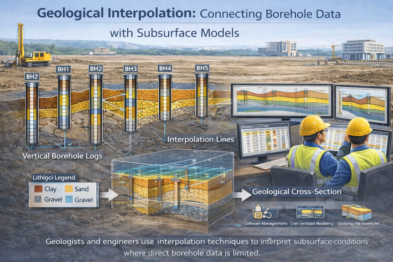
To understand how geological layers extend across an entire site, engineers and geologists must estimate conditions between boreholes. This process is known as interpolation.
Interpolation is widely used in geological modeling software to generate cross-sections, fence diagrams, and three-dimensional subsurface models. By analyzing borehole data, these programs estimate the likely position of geological layer boundaries between drilling locations.
Although interpolation algorithms can produce visually realistic models, they do not replace geological interpretation. Software can estimate patterns based on mathematical rules, but understanding geological processes remains essential for producing reliable subsurface models.
This article explains how geological interpolation works, the algorithms commonly used in geological software, the limitations of automated modeling, and the role of geological expertise in interpreting subsurface data.
Why Interpolation Is Necessary
Boreholes provide valuable information about subsurface geology, but they only sample specific points in space.
For example, a site investigation may include 10 boreholes across a construction site. Each borehole provides a vertical profile of soil and rock layers at its location, but the geological conditions between those boreholes remain unknown.
Interpolation helps estimate how geological layers extend between these data points.
Without interpolation, geological models would consist only of isolated borehole logs, providing little insight into regional stratigraphy.
Interpolation allows geological modeling software to:
- connect layers between boreholes
- generate cross-sections
- construct three-dimensional geological surfaces
- estimate subsurface volumes
These capabilities make interpolation essential for subsurface interpretation.
Basic Principles of Geological Interpolation
Interpolation works by estimating unknown values between known data points.
In geological modeling, the known data points are borehole observations. Each borehole provides information about the depth or elevation of geological layers at a specific location.
Interpolation algorithms analyze these data points and estimate the likely position of geological layer boundaries between boreholes.
For example, if a sand layer occurs at an elevation of 95 meters in one borehole and 90 meters in another borehole 50 meters away, the software may estimate that the layer gradually slopes between those two points.
This estimated surface becomes part of the geological model.
The accuracy of interpolation depends on the number and distribution of boreholes as well as the geological complexity of the site.
Types of Interpolation Methods
Geological software uses several mathematical techniques to interpolate subsurface layers.
Each method has advantages and limitations depending on the type of geological data being analyzed.
Linear Interpolation
Linear interpolation is one of the simplest methods used in cross-section construction.
This method assumes that geological layers extend in straight lines between boreholes.
For example, if the top of a clay layer occurs at 100 meters elevation in one borehole and 95 meters elevation in another borehole, linear interpolation will connect these points with a straight line.
Linear interpolation works well when geological layers change gradually between boreholes.
However, it may oversimplify complex geological environments.
Inverse Distance Weighting (IDW)
Inverse distance weighting is a commonly used interpolation method in spatial modeling.
This method estimates unknown values based on nearby data points, giving greater influence to points that are closer to the location being estimated.
In geological modeling, IDW can be used to estimate the elevation of geological surfaces between boreholes.
Because closer boreholes have greater influence, the resulting surface tends to reflect local geological conditions.
However, IDW may produce unrealistic surfaces if borehole spacing is irregular.
Kriging
Kriging is a more advanced interpolation method commonly used in geostatistics.
This technique analyzes spatial patterns in the data and estimates values based on statistical relationships between data points.
Kriging is often used in mineral resource estimation and groundwater modeling because it can produce smooth and statistically optimized surfaces.
However, kriging requires significant computational resources and careful parameter selection.
Natural Neighbor Interpolation
Natural neighbor interpolation estimates values based on nearby data points that surround the target location.
This method often produces smooth surfaces and is less sensitive to irregular borehole spacing.
Natural neighbor interpolation is commonly used in terrain modeling and geological surface generation.
Interpolating Geological Surfaces
In geological modeling, interpolation is typically used to generate surfaces representing geological boundaries.
Examples include:
- the top of a clay layer
- the base of a sand deposit
- the surface of bedrock
Each of these boundaries can be represented as a continuous surface across the investigation area.
Borehole data provides elevation values for these boundaries at specific locations.
Interpolation algorithms estimate how the surface extends between boreholes.
Once the surface is generated, it can be used to construct three-dimensional geological models.
Interpolation in Geological Cross-Sections
Interpolation also plays an important role in generating geological cross-sections.
When borehole logs are plotted along a section line, software must estimate how geological layers extend between the boreholes.
In many cross-section tools, interpolation is performed using simple linear connections between layer boundaries.
More advanced software may allow users to adjust interpolation parameters or manually modify layer correlations.
Cross-section interpolation must always be reviewed by geologists because automated algorithms may not fully capture geological complexity.
Factors That Influence Interpolation Accuracy
Several factors influence the accuracy of interpolation results.
Borehole Spacing
The distance between boreholes affects how much information is available for interpolation.
Closely spaced boreholes provide more data points and reduce uncertainty.
Widely spaced boreholes leave larger gaps that must be estimated by the software.
Data Quality
Errors in borehole data can significantly affect interpolation results.
For example, incorrect elevation values or inconsistent lithology descriptions may produce distorted surfaces.
Geological Complexity
Simple geological environments with uniform sediment layers are easier to interpolate.
Complex environments such as glacial deposits or river channel systems may contain abrupt changes that are difficult to model accurately.
Limitations of Automated Interpolation
Although interpolation algorithms can generate visually appealing geological models, they have limitations.
One major limitation is that software cannot fully understand geological processes.
For example, a sand layer may pinch out between two boreholes due to depositional changes. However, interpolation algorithms may incorrectly connect the layer across the entire area.
Similarly, erosion surfaces or structural features may not be detected automatically.
Because of these limitations, automated interpolation should always be considered an initial estimate rather than a final interpretation.
Role of Geological Expertise
Geological expertise plays a crucial role in interpreting interpolation results.
Geologists must review automated models and ensure that they are consistent with known geological processes.
This may involve:
- adjusting layer correlations
- modifying geological surfaces
- incorporating regional geological information
In many cases, geological interpretation combines automated interpolation with manual adjustments.
This approach allows geologists to incorporate both mathematical modeling and geological reasoning.
Improving Interpolation Results
Several strategies can improve the accuracy of geological interpolation.
Increasing Borehole Density
Additional boreholes provide more data points and reduce interpolation uncertainty.
Using Geophysical Data
Geophysical surveys such as seismic or resistivity measurements can provide additional information about subsurface structures.
Incorporating Geological Constraints
Geological models can include constraints such as known stratigraphic relationships or fault locations.
These constraints help guide interpolation algorithms.
Reviewing Models Carefully
Visualizing geological models from multiple perspectives helps identify unrealistic interpolation results.
Applications of Geological Interpolation
Interpolation is used in many geological and engineering applications.
Geotechnical Engineering
Engineers use interpolated geological surfaces to design foundations and evaluate soil stability.
Hydrogeology
Groundwater models rely on interpolated aquifer boundaries to simulate groundwater flow.
Mining and Resource Exploration
Mining companies use geostatistical interpolation to estimate ore grades between drill holes.
Environmental Investigations
Interpolation helps map contaminant plumes and understand subsurface transport pathways.
Future Trends in Geological Interpolation
Advances in computing technology are improving geological interpolation methods.
Machine learning techniques are beginning to assist with geological modeling by analyzing patterns in large datasets.
Cloud-based geological modeling platforms also allow teams to collaborate on subsurface models in real time.
Although these technologies offer powerful new tools, geological expertise remains essential for interpreting subsurface data.
Conclusion
Interpolation is a fundamental process in geological modeling. Because boreholes provide only discrete data points, interpolation algorithms are used to estimate how geological layers extend between drilling locations.
Modern geological software uses a variety of interpolation methods, including linear interpolation, inverse distance weighting, and kriging, to generate geological surfaces and subsurface models.
While these algorithms provide valuable insights, they cannot fully replace geological interpretation. Automated models must always be reviewed by experienced geologists to ensure that they accurately represent subsurface conditions.
By combining high-quality borehole data, advanced modeling software, and sound geological reasoning, engineers and geologists can produce reliable subsurface models that support safe infrastructure design and effective environmental management.
Learn more about our Solutions
- GaeaSynergy Platform for Geoscientific Analysis
- WinLoG Borehole and Well Log Data Management
- WinFence Cross-section and Fence Diagram Visualization
Related Articles
- GaeaSynergy: Integrated Geological, Geotechnical, and Environmental Data Management Platform
- Subsurface Visualization: Turning Borehole Data into Clear Geological Insight
- Geological Cross-Sections from Borehole Data: A Complete Engineering Guide
- Common Mistakes When Creating Geological Cross-Sections from Borehole Data
- How Borehole Spacing Affects Geological Cross-Section Accuracy
- Preparing Borehole Databases for Cross-Section Software
- How Lithological Correlation Works Between Boreholes
- Understanding Fence Diagrams in Geological Modeling
- Common Data Errors in Borehole Databases and How to Fix Them
- Using Geological Cross-Sections in Geotechnical Engineering
- Borehole Coordinate Systems and Mapping for Geological Modeling
- Depth vs Elevation in Borehole Databases for Geological Modeling
- Interpreting Geological Variability Between Boreholes
- Building Geological Cross-Sections from Borehole Data: A Step-by-Step Workflow
- Borehole Data Visualization Techniques for Geological Modeling
- Managing Large Borehole Data Sets in Engineering Projects
- Understanding Pinch-Outs and Missing Geological Layers in Subsurface Interpretation