
Introduction
Borehole drilling is one of the most important methods used to investigate subsurface geological conditions for engineering, environmental, and geological projects. Each borehole provides direct information about soil and rock layers beneath a specific location. Engineers and geologists use these borehole logs to interpret subsurface stratigraphy, construct geological cross-sections, and develop three-dimensional subsurface models.
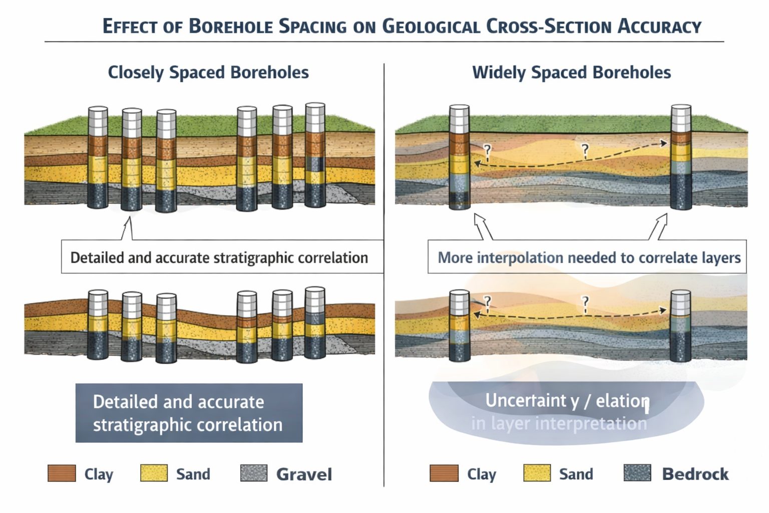
However, boreholes only sample a small portion of the subsurface. The geological conditions between boreholes must be interpreted rather than directly observed. The spacing between boreholes therefore plays a crucial role in determining the accuracy of geological interpretations.
When boreholes are closely spaced, geologists can correlate layers more confidently and detect variations in geological materials across a site. When boreholes are widely spaced, uncertainty increases because important geological features may exist between boreholes but remain undetected.
Understanding how borehole spacing influences geological interpretation is essential for designing effective site investigations and constructing reliable cross-sections. Engineers and geologists must balance the cost of drilling additional boreholes with the need to reduce uncertainty in subsurface conditions.
This article explores how borehole spacing affects cross-section accuracy, the geological variability that complicates interpretation, and the best practices for designing drilling programs that provide reliable subsurface information.
Boreholes as Subsurface Data Points
Each borehole represents a single vertical sample of the subsurface. During drilling operations, geologists record the sequence of geological materials encountered as the borehole penetrates soil and rock layers.
Typical borehole logs include:
- lithology descriptions
- depth intervals of geological layers
- soil classification data
- groundwater observations
- sample collection information
These logs provide valuable information about the vertical structure of the subsurface at specific locations.
However, boreholes do not directly reveal what occurs between them. Geologists must interpret how geological layers extend laterally across the site based on the available data.
In essence, boreholes act as data points within a larger geological system. The spacing between these data points determines how accurately the subsurface can be interpreted.
The Relationship Between Borehole Spacing and Geological Uncertainty
The greater the distance between boreholes, the greater the uncertainty about what exists between them.
When boreholes are closely spaced, geologists can observe how geological layers change across short distances. Variations in layer thickness, composition, and stratigraphy become easier to detect.
Closely spaced boreholes allow geologists to identify features such as:
- sediment lenses
- buried channels
- erosional surfaces
- layer pinch-outs
These features are often critical for understanding subsurface geology.
When boreholes are widely spaced, however, these features may remain undetected. Geological layers may appear continuous in cross-sections simply because there is no data to indicate otherwise.
This can lead to overly simplified interpretations of subsurface conditions.
Recognizing this uncertainty is essential when interpreting borehole data.
Geological Variability and Its Impact on Borehole Spacing
Natural geological processes often produce highly variable subsurface conditions. Sedimentary environments in particular can create complex patterns of soil and rock layers that change rapidly over short distances.
For example, river systems may deposit sand and gravel in narrow channels while surrounding areas accumulate finer sediments such as silt and clay. These channel deposits may extend only tens of meters across.
If boreholes are spaced farther apart than the width of the channel, the feature may be completely missed.
Glacial environments can produce even greater variability. Glacial deposits often contain mixtures of clay, silt, sand, gravel, and boulders that are distributed irregularly across the landscape.
These variations make it difficult to interpret subsurface conditions using widely spaced boreholes.
Increasing the density of boreholes helps capture this variability and improves the accuracy of geological models.
Borehole Spacing in Geological Cross-Sections
Geological cross-sections are constructed by correlating layers between boreholes along a section line. The reliability of these correlations depends heavily on borehole spacing.
When boreholes are closely spaced, geologists can identify gradual changes in layer thickness and composition. This makes it easier to determine whether layers represent the same geological unit.
When boreholes are widely spaced, however, geologists may be forced to assume continuity between layers even when this assumption may not be accurate.
For example, if two boreholes located 100 meters apart both contain a sand layer at similar depths, it may be tempting to connect these layers directly in a cross-section.
In reality, the sand layer may thin, transition into another material, or disappear entirely between the two boreholes.
Without additional data, this uncertainty cannot be fully resolved.
The Risk of Missing Geological Features
Widely spaced boreholes increase the risk of missing important geological features.
Some features that may be overlooked include:
Sand Lenses
Sand lenses are localized deposits of sand surrounded by finer sediments such as clay or silt. These lenses may be relatively small but can significantly influence groundwater flow.
Buried Channels
Ancient river channels may be filled with sand and gravel deposits that differ significantly from surrounding sediments.
If boreholes miss these channels, geological models may fail to represent important subsurface structures.
Pinch-Outs
Geological layers may gradually thin and disappear between boreholes. If boreholes are widely spaced, pinch-outs may not be detected.
Faults or Structural Features
In some geological environments, structural features such as faults may offset geological layers.
These features may be difficult to identify without sufficient borehole data.
Designing Effective Borehole Spacing
Determining appropriate borehole spacing requires careful consideration of several factors.
Project Objectives
Different types of projects require different levels of geological detail.
For example, small building foundations may require only a few boreholes, while major infrastructure projects may require extensive drilling programs.
Geological Complexity
Sites with highly variable geology require closer borehole spacing than sites with relatively uniform geological conditions.
Site Size
Larger sites generally require more boreholes to achieve adequate coverage.
Risk Tolerance
Projects with higher engineering risk may justify additional drilling to reduce uncertainty.
Balancing these factors helps ensure that drilling programs provide sufficient geological information without unnecessary costs.
Using Additional Data to Reduce Uncertainty
In some cases, borehole data can be supplemented with other investigation methods to improve subsurface interpretation.
Geophysical surveys are commonly used to detect geological variations between boreholes.
Examples include:
- seismic surveys
- electrical resistivity surveys
- ground penetrating radar
These techniques measure physical properties of subsurface materials and can identify variations that may indicate geological structures.
Although geophysical methods typically provide lower resolution data than borehole logs, they can help guide drilling programs and identify areas where additional boreholes may be needed.
Representing Uncertainty in Cross-Sections
Because geological interpretation always involves some level of uncertainty, cross-sections should communicate this uncertainty clearly.
Geologists may use several techniques to illustrate uncertainty, including:
- dashed lines for uncertain layer boundaries
- shading to indicate interpreted regions
- notes describing data limitations
Communicating uncertainty helps engineers and project stakeholders understand the reliability of geological interpretations.
Adaptive Drilling Strategies
One effective approach for managing borehole spacing is to use an adaptive drilling strategy.
In this approach, initial boreholes are drilled to obtain a general understanding of subsurface conditions. Based on the results, additional boreholes are drilled in areas where more detailed information is needed.
Adaptive drilling allows engineers to focus resources on areas where uncertainty is highest.
This approach is commonly used in environmental investigations and mining exploration.
Best Practices for Managing Borehole Spacing
Several best practices can help improve the accuracy of cross-sections and subsurface models.
First, distribute boreholes evenly across the investigation area to avoid leaving large unsampled regions.
Second, consider the geological history of the site when interpreting borehole data.
Third, supplement borehole data with geophysical surveys when possible.
Fourth, use multiple cross-sections and fence diagrams to evaluate geological layers from different directions.
Finally, acknowledge uncertainty when interpreting widely spaced borehole data.
Conclusion
Borehole spacing plays a critical role in determining the accuracy of geological cross-sections and subsurface models. Because boreholes provide only discrete samples of the subsurface, large gaps between boreholes introduce uncertainty into geological interpretation.
Closely spaced boreholes allow geologists to detect geological variability and identify important features such as sediment lenses, buried channels, and pinch-outs. Widely spaced boreholes may miss these features, leading to simplified interpretations of subsurface conditions.
Designing effective drilling programs requires balancing the need for accurate geological information with the cost of additional boreholes. By considering geological complexity, project objectives, and risk tolerance, engineers and geologists can develop investigation strategies that provide reliable subsurface data.
Understanding the influence of borehole spacing ultimately helps improve the accuracy of geological models and supports better engineering decisions.
Learn more about our Solutions
- GaeaSynergy Platform for Geoscientific Analysis
- WinLoG Borehole and Well Log Data Management
- WinFence Cross-section and Fence Diagram Visualization
Related Articles
- GaeaSynergy: Integrated Geological, Geotechnical, and Environmental Data Management Platform
- Subsurface Visualization: Turning Borehole Data into Clear Geological Insight
- Geological Cross-Sections from Borehole Data: A Complete Engineering Guide
- Common Mistakes When Creating Geological Cross-Sections from Borehole Data
- Preparing Borehole Databases for Cross-Section Software
- How Lithological Correlation Works Between Boreholes
- Understanding Fence Diagrams in Geological Modeling
- Common Data Errors in Borehole Databases and How to Fix Them
- Using Geological Cross-Sections in Geotechnical Engineering
- Borehole Coordinate Systems and Mapping for Geological Modeling
- Depth vs Elevation in Borehole Databases for Geological Modeling
- Interpreting Geological Variability Between Boreholes
- Building Geological Cross-Sections from Borehole Data: A Step-by-Step Workflow
- How Geological Software Interpolates Subsurface Layers Between Boreholes
- Borehole Data Visualization Techniques for Geological Modeling
- Managing Large Borehole Data Sets in Engineering Projects
- Understanding Pinch-Outs and Missing Geological Layers in Subsurface Interpretation