
Introduction
Lithological correlation is one of the most important tasks performed during geological and geotechnical investigations. It involves identifying and connecting similar geological layers between boreholes in order to reconstruct subsurface stratigraphy.
Because boreholes provide only vertical snapshots of subsurface conditions, geologists must determine how layers extend horizontally across a site. Lithological correlation transforms isolated borehole logs into continuous geological interpretations that can be visualized through cross-sections, fence diagrams, and three-dimensional subsurface models.
The ability to correlate layers accurately is essential for many engineering and environmental applications. Engineers rely on these correlations to understand soil stratigraphy beneath construction sites, evaluate groundwater flow pathways, and identify geological structures that may affect infrastructure stability.
However, lithological correlation is rarely straightforward. Geological materials often vary laterally due to natural depositional processes, erosion, and tectonic activity. Layers may thin, merge, change composition, or disappear entirely between boreholes.
Understanding how to interpret these variations is essential for producing reliable geological models.
This article explains how lithological correlation works, the geological principles behind layer correlation, the challenges geologists face when interpreting borehole data, and the best practices for building accurate subsurface interpretations.
Understanding Lithology in Borehole Logs
Lithology refers to the physical characteristics of geological materials. When drilling boreholes, geologists describe the materials encountered based on factors such as grain size, composition, texture, and color.
Common lithological categories encountered in borehole logs include:
- clay
- silt
- sand
- gravel
- glacial till
- bedrock
In many cases, materials are described using combinations of these terms. For example:
- silty sand
- clayey silt
- sandy gravel
These descriptions provide insight into the depositional environment that formed the geological layer.
Borehole logs typically record lithology alongside depth intervals that indicate where each material occurs within the borehole.
Although these logs provide valuable information about vertical geological conditions, they do not directly reveal how these layers extend between boreholes. Lithological correlation is the process used to interpret these relationships.
Why Lithological Correlation Is Important
Lithological correlation allows geologists to reconstruct the structure of subsurface geology.
Without correlation, borehole logs remain isolated data points that provide limited insight into geological patterns across a site.
By connecting layers between boreholes, geologists can build cross-sections that illustrate how geological materials extend beneath the ground surface.
These interpretations are essential for several reasons.
In geotechnical engineering, correlated layers help engineers understand the distribution of soil types beneath construction sites. This information supports foundation design, slope stability analysis, and settlement predictions.
In hydrogeology, lithological correlations help identify aquifers and confining layers that control groundwater flow.
Environmental scientists also use these correlations to understand how contaminants move through soil and groundwater systems.
Lithological correlation therefore forms the foundation of many subsurface analyses.
Geological Principles Used in Correlation
Geologists rely on several fundamental geological principles when correlating layers between boreholes.
Law of Superposition
The law of superposition states that in undisturbed sedimentary sequences, older layers lie beneath younger layers.
This principle helps geologists determine the relative age of geological units.
When correlating boreholes, geologists examine the vertical order of layers to ensure that correlations follow a consistent stratigraphic sequence.
Stratigraphic Continuity
Sedimentary layers are often deposited across large areas. This means that similar layers may appear in multiple boreholes.
However, this continuity is rarely perfect because sediment deposition varies across the landscape.
Understanding the depositional environment helps geologists determine whether layers are likely to extend between boreholes.
Lateral Facies Changes
Sedimentary materials often change composition gradually across a region.
For example, a sand layer deposited by a river channel may transition into silty sand or silt as sediment energy decreases.
These transitions are known as facies changes.
Recognizing facies changes is essential for interpreting how geological layers evolve across a site.
Methods for Correlating Borehole Layers
Geologists use several techniques to correlate layers between boreholes.
Lithological Similarity
The simplest approach is to connect layers with similar lithology descriptions.
For example, sand layers appearing at similar depths in multiple boreholes may represent the same geological unit.
However, this method alone can be misleading because similar materials may have been deposited during different geological events.
Stratigraphic Position
The position of a layer within the stratigraphic sequence can provide valuable clues.
For example, if a sand layer consistently occurs between two clay layers across multiple boreholes, it may represent a continuous depositional unit.
Layer Thickness Trends
Changes in layer thickness can help identify correlations.
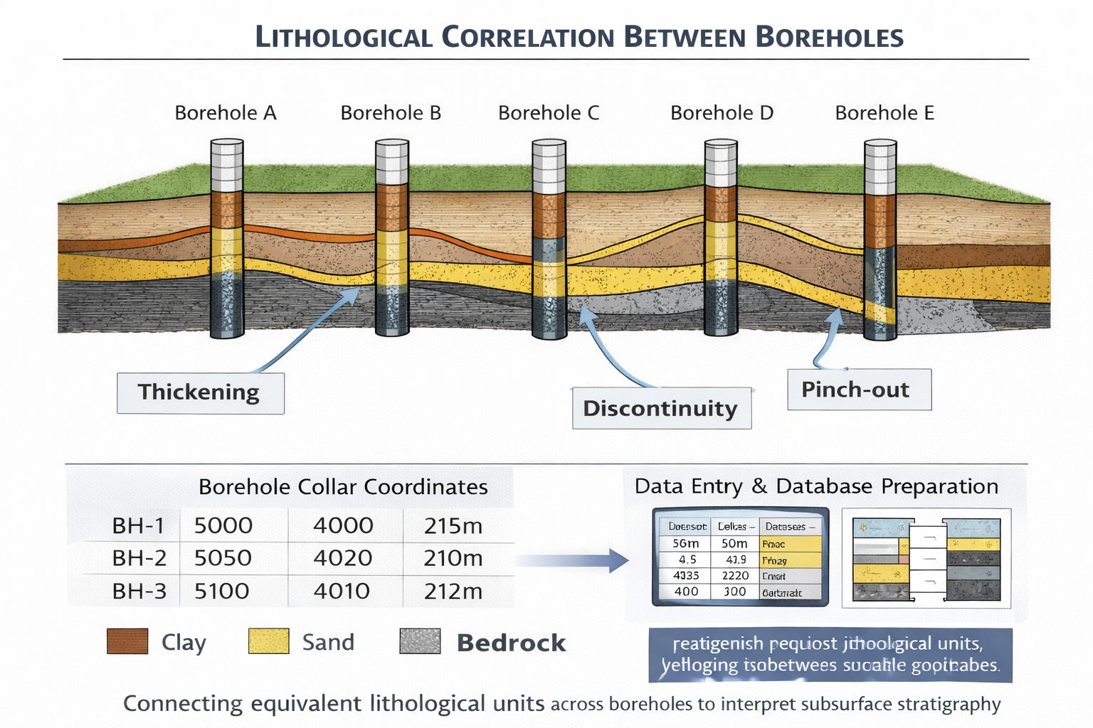
If a layer gradually thins between boreholes, it may indicate that the layer is approaching a pinch-out.
Regional Geological Context
Knowledge of regional geology helps guide correlation decisions.
For example, glacial environments often produce complex mixtures of sediments, while river systems may create predictable patterns of sand and gravel deposition.
Understanding these depositional processes helps geologists interpret borehole data more accurately.
Challenges in Lithological Correlation
Several factors make lithological correlation difficult.
Geological Variability
Natural geological systems are highly variable. Sedimentary layers may change thickness, composition, or grain size across short distances.
This variability makes it difficult to determine whether layers in different boreholes represent the same geological unit.
Pinch-Outs
Pinch-outs occur when a geological layer gradually thins and disappears between boreholes.
If pinch-outs are not recognized, cross-sections may incorrectly connect layers that should terminate.
Erosion
Erosional processes may remove portions of geological layers before new sediments are deposited.
This can create gaps in the stratigraphic record.
Borehole Spacing
The spacing between boreholes also affects correlation accuracy.
Widely spaced boreholes provide limited information about conditions between them, increasing uncertainty in geological interpretation.
Lithological Correlation in Cross-Sections
Geological cross-sections provide one of the most common ways to visualize lithological correlations.
To construct a cross-section, boreholes are aligned along a section line and their lithology intervals are plotted vertically.
Geologists then connect layers that appear to represent the same geological unit.
These connections create continuous geological layers across the cross-section.
Cross-sections allow engineers and geologists to visualize:
- layer continuity
- thickness variations
- structural features
- erosional surfaces
Cross-sections are widely used in engineering reports and geological studies because they communicate complex subsurface information in a clear visual format.
Lithological Correlation in Fence Diagrams
Fence diagrams extend the concept of cross-sections by combining multiple intersecting sections into a three-dimensional framework.
This approach allows geologists to analyze layer correlations in multiple directions.
Fence diagrams can reveal geological features that may not be visible in a single cross-section.
For example, a buried river channel may appear as isolated sand layers in individual cross-sections but become clearly visible when multiple sections intersect.
Fence diagrams therefore improve the reliability of lithological correlations.
Role of Software in Lithological Correlation
Modern geological software can assist with lithological correlation by organizing borehole data and generating visualizations.
These programs allow users to import borehole databases and display lithology intervals graphically.
Some software platforms include automated correlation algorithms that attempt to connect similar layers between boreholes.
However, these automated correlations should always be reviewed by experienced geologists.
Software cannot fully interpret depositional environments or geological processes.
Human expertise remains essential for producing reliable correlations.
Best Practices for Lithological Correlation
Several best practices can improve correlation accuracy.
First, ensure that borehole databases are properly prepared before analysis.
Lithology descriptions should be standardized to avoid confusion between similar materials.
Second, verify borehole coordinates and elevations.
Accurate spatial positioning is essential for correlating layers correctly.
Third, consider regional geological history when interpreting borehole data.
Finally, review correlations across multiple cross-sections to ensure consistency.
Applying these practices improves the reliability of geological models.
Engineering Applications of Lithological Correlation
Lithological correlation plays a crucial role in many engineering and environmental applications.
In geotechnical engineering, correlated layers help engineers identify zones of weak soil that may affect foundation stability.
In hydrogeology, correlations help identify aquifers and confining layers that influence groundwater flow.
Environmental scientists also rely on lithological correlations to evaluate contaminant migration pathways.
Accurate correlations therefore support safer infrastructure design and more effective environmental management.
Conclusion
Lithological correlation is a fundamental process in geological interpretation. By connecting layers between boreholes, geologists can reconstruct subsurface stratigraphy and develop a clearer understanding of geological conditions.
Although borehole logs provide valuable vertical information, interpreting how layers extend between boreholes requires careful analysis of geological processes, stratigraphy, and depositional environments.
Challenges such as facies changes, pinch-outs, erosion, and borehole spacing can complicate correlation. Nevertheless, by applying sound geological principles and maintaining high-quality borehole databases, geologists can produce reliable subsurface interpretations.
Lithological correlation remains an essential step in constructing geological cross-sections, fence diagrams, and three-dimensional subsurface models that support engineering design and environmental analysis.
Learn more about our Solutions
- GaeaSynergy Platform for Geoscientific Analysis
- WinLoG Borehole and Well Log Data Management
- WinFence Cross-section and Fence Diagram Visualization
Related Articles
- GaeaSynergy: Integrated Geological, Geotechnical, and Environmental Data Management Platform
- Subsurface Visualization: Turning Borehole Data into Clear Geological Insight
- Geological Cross-Sections from Borehole Data: A Complete Engineering Guide
- Common Mistakes When Creating Geological Cross-Sections from Borehole Data
- How Borehole Spacing Affects Geological Cross-Section Accuracy
- Preparing Borehole Databases for Cross-Section Software
- Understanding Fence Diagrams in Geological Modeling
- Common Data Errors in Borehole Databases and How to Fix Them
- Using Geological Cross-Sections in Geotechnical Engineering
- Borehole Coordinate Systems and Mapping for Geological Modeling
- Depth vs Elevation in Borehole Databases for Geological Modeling
- Interpreting Geological Variability Between Boreholes
- Building Geological Cross-Sections from Borehole Data: A Step-by-Step Workflow
- How Geological Software Interpolates Subsurface Layers Between Boreholes
- Borehole Data Visualization Techniques for Geological Modeling
- Managing Large Borehole Data Sets in Engineering Projects
- Understanding Pinch-Outs and Missing Geological Layers in Subsurface Interpretation