
Introduction
Borehole databases are the backbone of modern geological and geotechnical investigations. Engineers and geologists rely on borehole data to interpret subsurface conditions, construct geological cross-sections, generate fence diagrams, and build three-dimensional geological models.
However, the reliability of these interpretations depends entirely on the quality of the borehole data being used. Even small data errors can cause significant problems in geological modeling and engineering analysis.
Common issues such as inconsistent lithology descriptions, incorrect depth intervals, coordinate errors, and duplicate borehole records can lead to distorted cross-sections or misleading geological interpretations.
Because geological software relies on structured datasets rather than expert judgment, poorly prepared borehole databases can cause automated modeling tools to generate unrealistic results.
Identifying and correcting data errors before using borehole data in geological modeling is therefore essential.
This article examines the most common types of data errors found in borehole databases, explains how these errors affect geological interpretation, and provides practical strategies for identifying and correcting them.
Why Data Quality Is Critical in Borehole Databases
Borehole logs represent the primary source of information about subsurface conditions. Each borehole contains valuable observations about soil layers, rock formations, groundwater levels, and sample properties.
When these logs are combined into a borehole database, they become a powerful dataset that can be used to analyze subsurface geology across an entire project area.
However, geological modeling software depends on structured data fields to interpret borehole information. Unlike geologists, software programs cannot recognize ambiguous or inconsistent data entries.
If a borehole database contains errors, the software may misinterpret geological layers or generate incorrect visualizations.
For example, a simple error in borehole coordinates may place a borehole in the wrong location, distorting cross-sections and geological models.
Ensuring high-quality data is therefore one of the most important responsibilities in geological data management.
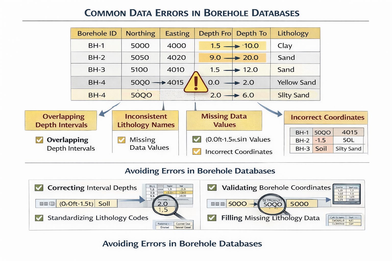
Inconsistent Lithology Descriptions
One of the most common issues in borehole databases is inconsistent lithology descriptions.
During field logging, geologists often describe soils using detailed terminology based on their observations. While these descriptions may be accurate, they can vary significantly between boreholes.
For example, similar materials may be recorded as:
- silty sand
- sand with silt
- sandy silt
- fine sand
Although these materials may represent similar geological units, database systems and modeling software may treat them as separate layers.
This inconsistency can make it difficult to correlate layers between boreholes.
Standardizing lithology descriptions is therefore an important step in preparing borehole databases.
Many organizations group materials into simplified categories such as:
- clay
- silt
- sand
- gravel
- bedrock
Detailed descriptions can still be stored in secondary fields, but standardized categories improve layer correlation.
Overlapping Depth Intervals
Another common data error involves overlapping depth intervals.
Each lithology interval should represent a continuous section of the borehole without overlapping with adjacent intervals.
For example:
| From Depth | To Depth | Lithology |
|---|---|---|
| 0.0 | 2.0 | Clay |
| 2.0 | 5.0 | Sand |
| 4.8 | 6.5 | Gravel |
In this example, the sand and gravel layers overlap between depths of 4.8 and 5.0 meters.
When cross-section software encounters overlapping intervals, it may produce unrealistic geological layers.
Correcting these errors requires reviewing borehole logs and ensuring that intervals are continuous.
Missing Depth Intervals
In some cases, borehole logs may contain gaps between intervals.
For example:
| From Depth | To Depth | Lithology |
|---|---|---|
| 0.0 | 2.0 | Clay |
| 2.0 | 4.0 | Sand |
| 5.0 | 8.0 | Gravel |
In this case, there is a missing interval between depths of 4.0 and 5.0 meters.
These gaps can occur when data is entered manually or when borehole logs are digitized from paper records.
Missing intervals create uncertainty in geological interpretation and may cause problems during cross-section generation.
All borehole intervals should cover the entire depth of the borehole.
Incorrect Borehole Coordinates
Borehole coordinates determine the spatial position of each borehole within geological models.
If coordinates are incorrect, boreholes may appear in the wrong location.
This can significantly distort geological cross-sections and fence diagrams.
Common coordinate errors include:
- incorrect coordinate systems
- swapped easting and northing values
- missing elevation data
For example, if one borehole is recorded using geographic coordinates while others use projected coordinates, the borehole may appear far outside the project area.
Verifying coordinate systems and spatial data is essential before importing borehole databases into geological software.
Duplicate Borehole Records
Duplicate borehole entries can occur when data is imported from multiple sources or when borehole logs are recorded under slightly different names.
For example, the same borehole may appear in the database as:
- BH01
- BH-01
- Borehole01
If these entries are treated as separate boreholes, geological models may include duplicate data points.
Duplicate boreholes can distort cross-sections and create confusion during interpretation.
Maintaining consistent naming conventions helps prevent this problem.
Incorrect Ground Elevations
Ground elevation data is critical for converting depth measurements into absolute elevations.
If ground elevations are incorrect, geological layers may appear at incorrect depths within cross-sections.
For example, if one borehole has an incorrect elevation value, the entire stratigraphic sequence may appear shifted relative to other boreholes.
Elevation errors are particularly problematic when modeling sites with significant topographic variation.
Verifying ground elevations using survey data helps ensure accuracy.
Misordered Lithology Intervals
Lithology intervals should be arranged in order from the surface downward.
However, database errors may cause intervals to appear out of sequence.
For example:
| From Depth | To Depth | Lithology |
|---|---|---|
| 5.0 | 7.0 | Sand |
| 0.0 | 2.0 | Clay |
| 2.0 | 5.0 | Silt |
When intervals are misordered, cross-section software may interpret the geological sequence incorrectly.
Sorting intervals by depth is an important step in database preparation.
Inconsistent Units
Unit inconsistencies can also create major problems in borehole databases.
Some borehole logs may record depths in meters, while others may use feet.
If these units are mixed within the same database, geological layers may appear at incorrect depths.
Ensuring consistent measurement units across all borehole records is essential.
Data Entry Errors
Manual data entry can introduce a wide range of errors, including:
- incorrect numeric values
- typographical mistakes
- misplaced decimal points
For example, recording a depth of 50 meters instead of 5.0 meters can dramatically distort geological interpretations.
Automated validation checks can help identify unusual values.
Quality Control Procedures
Quality control procedures help identify and correct data errors before borehole databases are used for geological modeling.
Common quality control checks include:
- verifying borehole coordinates
- reviewing lithology descriptions
- checking interval continuity
- confirming measurement units
- identifying duplicate records
Automated scripts or spreadsheet formulas can detect many of these issues quickly.
Regular data validation improves database reliability.
Using Software Tools for Data Validation
Many geological database systems include tools for validating borehole data.
These tools can automatically detect:
- overlapping intervals
- missing depth values
- coordinate inconsistencies
Automated validation reduces the time required to identify errors in large datasets.
However, human review remains important for interpreting complex geological data.
Best Practices for Maintaining Borehole Databases
Several best practices can help maintain high-quality borehole databases.
First, establish standardized logging procedures to ensure consistent lithology descriptions.
Second, implement clear naming conventions for boreholes.
Third, verify spatial data and coordinate systems before importing data into geological software.
Fourth, perform regular quality control checks.
Finally, maintain documentation describing database structure and data standards.
These practices improve data consistency and support reliable geological interpretation.
The Impact of Data Errors on Geological Modeling
Errors in borehole databases can have significant consequences for geological modeling.
Incorrect data may lead to:
- distorted cross-sections
- incorrect layer correlations
- unrealistic geological models
These errors can affect engineering decisions and project outcomes.
Ensuring data quality is therefore essential for producing reliable geological interpretations.
Conclusion
Borehole databases play a central role in geological and geotechnical investigations. They store the information used to construct cross-sections, fence diagrams, and subsurface models.
However, these databases are only as reliable as the data they contain. Common errors such as inconsistent lithology descriptions, overlapping depth intervals, coordinate mistakes, and duplicate records can lead to misleading geological interpretations.
By implementing standardized data structures, performing quality control checks, and using automated validation tools, engineers and geologists can ensure that borehole databases remain accurate and reliable.
High-quality borehole data ultimately supports better geological models, more accurate engineering analysis, and improved decision-making in infrastructure and environmental projects.
Learn more about our Solutions
- GaeaSynergy Platform for Geoscientific Analysis
- WinLoG Borehole and Well Log Data Management
- WinFence Cross-section and Fence Diagram Visualization
Related Articles
- GaeaSynergy: Integrated Geological, Geotechnical, and Environmental Data Management Platform
- Subsurface Visualization: Turning Borehole Data into Clear Geological Insight
- Geological Cross-Sections from Borehole Data: A Complete Engineering Guide
- Common Mistakes When Creating Geological Cross-Sections from Borehole Data
- How Borehole Spacing Affects Geological Cross-Section Accuracy
- Preparing Borehole Databases for Cross-Section Software
- How Lithological Correlation Works Between Boreholes
- Understanding Fence Diagrams in Geological Modeling
- Using Geological Cross-Sections in Geotechnical Engineering
- Borehole Coordinate Systems and Mapping for Geological Modeling
- Depth vs Elevation in Borehole Databases for Geological Modeling
- Interpreting Geological Variability Between Boreholes
- Building Geological Cross-Sections from Borehole Data: A Step-by-Step Workflow
- How Geological Software Interpolates Subsurface Layers Between Boreholes
- Borehole Data Visualization Techniques for Geological Modeling
- Managing Large Borehole Data Sets in Engineering Projects
- Understanding Pinch-Outs and Missing Geological Layers in Subsurface Interpretation