
Introduction
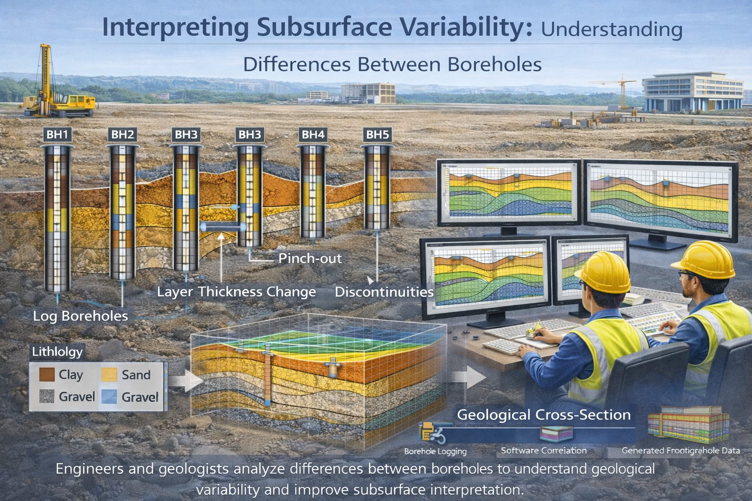
Understanding subsurface geology is one of the central challenges in geotechnical engineering, hydrogeology, environmental science, and resource exploration. Engineers and geologists rely heavily on borehole investigations to gather information about soil and rock layers beneath the ground surface. Each borehole provides a vertical profile of geological materials encountered during drilling.
However, boreholes only reveal conditions at specific locations. The geological conditions between boreholes must be interpreted rather than directly observed. This creates uncertainty in subsurface modeling because geological layers rarely extend uniformly across large areas.
Natural geological processes such as sediment deposition, erosion, glacial activity, and tectonic movement often produce highly variable subsurface conditions. As a result, layers may change thickness, composition, or elevation between boreholes. In some cases, geological units may pinch out or be replaced by entirely different materials over relatively short distances.
Interpreting these variations is a key task in geological analysis. Engineers and geologists must use borehole data, geological principles, and spatial interpretation techniques to estimate how geological layers extend between boreholes.
This article explores how geological variability occurs in the subsurface, how it affects borehole interpretation, and how professionals use cross-sections, fence diagrams, and geological modeling tools to interpret variability between boreholes.
The Nature of Subsurface Variability
Subsurface geology is rarely uniform. Even within relatively small areas, geological materials can vary significantly due to the processes that formed them.
For example, sedimentary deposits created by rivers, glaciers, and coastal environments often show complex patterns of sand, silt, clay, and gravel. These materials may be deposited in irregular shapes and may change rapidly across short distances.
Several geological processes contribute to subsurface variability.
Sedimentary Deposition
Sedimentary environments often produce layers that vary laterally. River channels, for example, may deposit coarse sand and gravel in narrow channels while surrounding floodplains accumulate fine sediments such as silt and clay.
These depositional patterns create geological layers that may appear in some boreholes but not in others.
Erosion
Erosional processes can remove portions of previously deposited layers before new sediments are deposited.
For example, an ancient river channel may cut through older sediments and later become filled with different materials. Boreholes drilled across such areas may show significant variations in stratigraphy.
Glacial Processes
Glacial environments often produce highly heterogeneous deposits. Glaciers transport a mixture of sediments ranging from clay to large boulders.
When glaciers retreat, these materials are deposited in irregular patterns that can create complex subsurface conditions.
Structural Deformation
Tectonic activity can also create variability in subsurface geology. Faults and folds may displace geological layers, causing them to appear at different elevations in different boreholes.
Understanding these geological processes helps geologists interpret the variations observed in borehole data.
Boreholes as Point Samples
Boreholes provide valuable information about subsurface geology, but they represent only point samples of a much larger geological system.
Each borehole reveals the sequence of geological layers at a single location. When multiple boreholes are drilled across a site, geologists must determine how these layers extend between the boreholes.
Because the subsurface cannot be observed directly between drilling locations, interpretations must rely on geological reasoning and interpolation.
The spacing between boreholes plays a major role in determining how much uncertainty exists in these interpretations.
Closely spaced boreholes provide more information about subsurface conditions and reduce uncertainty. Widely spaced boreholes leave larger gaps in the dataset, increasing the possibility that geological features exist between boreholes but remain undetected.
Types of Geological Variability
Several types of variability commonly appear when interpreting borehole data.
Thickness Variations
Geological layers often change thickness across a site. A sand layer may be thick in one borehole and gradually thin in another.
These thickness variations may indicate depositional patterns or erosion.
Facies Changes
Facies changes occur when the composition of a geological layer changes across a region.
For example, a sandy deposit may gradually transition into silty sand or clay as the energy of the depositional environment decreases.
Recognizing facies transitions is essential for accurate lithological correlation.
Pinch-Outs
Pinch-outs occur when a geological layer gradually thins until it disappears completely.
Pinch-outs are common in sedimentary environments and can significantly affect cross-section interpretation.
Localized Deposits
Some geological features are highly localized. Examples include sand lenses, gravel pockets, and buried channels.
These features may appear in only a few boreholes, making them difficult to interpret without additional data.
Borehole Spacing and Interpretation Uncertainty
The spacing between boreholes strongly influences the ability to interpret geological variability.
When boreholes are closely spaced, geologists can observe gradual changes in layer thickness and composition. This allows more accurate correlation between boreholes.
When boreholes are widely spaced, however, large portions of the subsurface remain unsampled.
For example, if two boreholes are located 100 meters apart, a buried sand channel located between them may go completely undetected.
Because of this uncertainty, geological interpretations between widely spaced boreholes should be treated with caution.
Engineers often incorporate safety factors in their designs to account for this uncertainty.
Using Geological Cross-Sections to Interpret Variability
Geological cross-sections are one of the primary tools used to interpret variability between boreholes.
Cross-sections display borehole logs along a section line and connect geological layers between them.
By examining cross-sections, geologists can identify patterns such as:
- layer thickness variations
- facies transitions
- erosional surfaces
- structural offsets
Cross-sections help transform isolated borehole logs into a continuous geological interpretation.
However, cross-sections represent interpretations rather than exact representations of subsurface geology.
Geologists must consider the possibility that additional variability exists between boreholes.
Fence Diagrams and Multi-Directional Analysis
Fence diagrams extend the concept of cross-sections by combining multiple intersecting sections into a three-dimensional framework.
This allows geologists to analyze subsurface conditions from multiple directions.
For example, a sand layer that appears continuous in one cross-section may be revealed as a localized deposit when viewed from another direction.
Fence diagrams are particularly useful for identifying geological features such as buried channels and sediment lenses.
By analyzing multiple cross-sections together, geologists can reduce uncertainty in subsurface interpretation.
Role of Geological Modeling Software
Modern geological modeling software allows engineers and geologists to visualize subsurface variability more effectively.
These programs can import borehole databases and generate cross-sections, fence diagrams, and three-dimensional geological models.
Interpolation algorithms estimate how geological layers extend between boreholes.
However, automated interpolation has limitations. Software may generate smooth surfaces that do not fully represent the complexity of geological processes.
Human interpretation remains essential for evaluating these models.
Geologists must review automated results and adjust interpretations when necessary.
Managing Uncertainty in Subsurface Interpretation
Because geological variability cannot be completely eliminated, engineers and geologists must manage uncertainty when interpreting borehole data.
Several strategies help reduce uncertainty.
Increasing Borehole Density
Drilling additional boreholes provides more data points and reduces the gaps between observations.
Using Geophysical Surveys
Geophysical methods such as seismic surveys or electrical resistivity can provide additional information about subsurface structures.
Incorporating Regional Geological Knowledge
Understanding the geological history of a region helps guide interpretation of borehole data.
Communicating Uncertainty
Engineering reports often include discussions of data limitations and interpretation uncertainty.
Clear communication helps ensure that project stakeholders understand the reliability of subsurface models.
Engineering Implications of Geological Variability
Geological variability can significantly affect engineering design.
For example, a foundation may encounter different soil types across a site due to variations in subsurface stratigraphy.
Similarly, groundwater flow may be influenced by localized permeable layers such as sand lenses.
Ignoring geological variability can lead to unexpected conditions during construction.
For this reason, engineers must carefully interpret borehole data and consider the possibility of subsurface variation.
Best Practices for Interpreting Borehole Data
Several best practices can improve the interpretation of geological variability between boreholes.
First, ensure that borehole data is accurately recorded and stored in well-structured databases.
Second, standardize lithology descriptions so that similar materials can be correlated consistently.
Third, use multiple cross-sections to analyze geological conditions across the site.
Fourth, consider regional geological processes when interpreting subsurface patterns.
Finally, review geological models carefully and update interpretations when new data becomes available.
These practices help produce more reliable subsurface interpretations.
Conclusion
Interpreting geological variability between boreholes is one of the most important tasks in subsurface investigation. Because boreholes provide only point samples of the subsurface, geologists must use interpretation techniques to estimate how geological layers extend between them.
Natural geological processes create complex patterns of deposition, erosion, and structural deformation that lead to significant variability in subsurface conditions.
Tools such as geological cross-sections, fence diagrams, and three-dimensional models help engineers and geologists visualize this variability and develop more accurate interpretations.
Although uncertainty can never be completely eliminated, careful data analysis, additional investigation methods, and sound geological reasoning can greatly improve our understanding of subsurface conditions.
Accurate interpretation of geological variability ultimately supports safer infrastructure design, better groundwater management, and more reliable environmental assessments.
Learn more about our Solutions
- GaeaSynergy Platform for Geoscientific Analysis
- WinLoG Borehole and Well Log Data Management
- WinFence Cross-section and Fence Diagram Visualization
Related Articles
- GaeaSynergy: Integrated Geological, Geotechnical, and Environmental Data Management Platform
- Subsurface Visualization: Turning Borehole Data into Clear Geological Insight
- Geological Cross-Sections from Borehole Data: A Complete Engineering Guide
- Common Mistakes When Creating Geological Cross-Sections from Borehole Data
- How Borehole Spacing Affects Geological Cross-Section Accuracy
- Preparing Borehole Databases for Cross-Section Software
- How Lithological Correlation Works Between Boreholes
- Understanding Fence Diagrams in Geological Modeling
- Common Data Errors in Borehole Databases and How to Fix Them
- Using Geological Cross-Sections in Geotechnical Engineering
- Borehole Coordinate Systems and Mapping for Geological Modeling
- Depth vs Elevation in Borehole Databases for Geological Modeling
- Building Geological Cross-Sections from Borehole Data: A Step-by-Step Workflow
- How Geological Software Interpolates Subsurface Layers Between Boreholes
- Borehole Data Visualization Techniques for Geological Modeling
- Managing Large Borehole Data Sets in Engineering Projects
- Understanding Pinch-Outs and Missing Geological Layers in Subsurface Interpretation