
Introduction
Across the geoscience industry, vast volumes of geological data remain locked in legacy archives. These archives—often consisting of paper records, scanned images, field notebooks, maps, seismic sections, and well logs—represent decades of exploration, research, and operational investment. Yet much of this data is underutilized because it exists in formats that are not easily searchable, shareable, or compatible with modern analytical tools.
As organizations increasingly adopt digital workflows, artificial intelligence, and advanced subsurface modeling, the need to transform legacy geological archives into structured digital databases has become critical. Digitization is only the first step. True value is unlocked when data is organized, standardized, and structured in a way that enables efficient retrieval, integration, and analysis.
This article explores the process, technologies, challenges, and best practices involved in converting legacy geological archives into structured digital databases, enabling organizations to maximize the value of their historical data assets.
Understanding Legacy Geological Archives
Legacy geological archives typically include a wide range of data types accumulated over many years.
Common archive components
- Geophysical well logs (paper and scanned)
- Seismic sections and field records
- Geological maps and cross-sections
- Core photographs and descriptions
- Drilling reports and lithological logs
- Environmental and hydrogeological data
These datasets are often stored in:
- Filing cabinets
- Warehouses
- Microfilm archives
- Unstructured digital folders
While rich in information, these archives lack the structure required for modern data-driven workflows.
Why Structured Digital Databases Matter
Transforming legacy data into structured databases provides significant advantages.
Improved data accessibility
Structured databases allow users to quickly search and retrieve relevant data.
Integration with modern tools
Data can be used in GIS systems, reservoir modeling software, and machine learning platforms.
Enhanced decision-making
Structured data supports more accurate and data-driven interpretations.
Data preservation
Digitization protects data from physical degradation and loss.
Scalability
Databases can handle large volumes of data and support future growth.
Without structure, digitized data remains difficult to use. Structuring is what turns data into actionable knowledge.
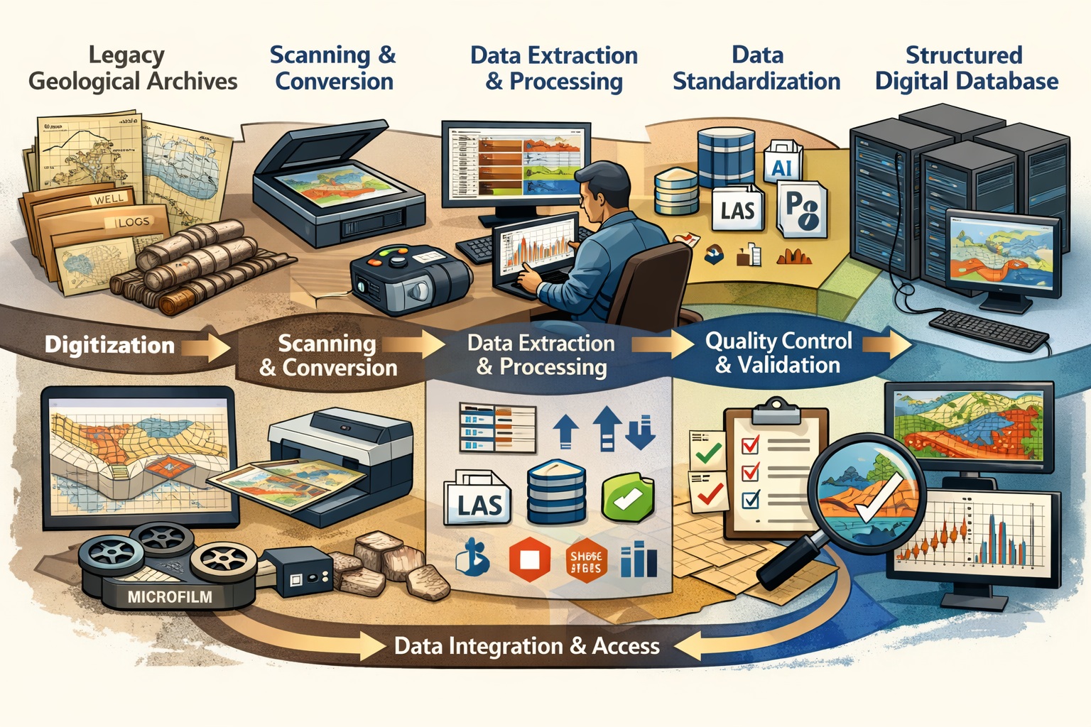
The Transformation Workflow
Converting legacy archives into structured digital databases involves several key stages:
- Data inventory and assessment
- Digitization of physical records
- Data extraction and interpretation
- Data structuring and standardization
- Database design and implementation
- Quality control and validation
- Integration and deployment
Each stage is essential for building a reliable and usable database.
Step 1: Data Inventory and Assessment
The first step is understanding what data exists.
Key activities:
- Cataloging available records
- Identifying data types and formats
- Assessing data quality and condition
- Prioritizing high-value datasets
This stage provides a roadmap for the digitization and structuring process.
Step 2: Digitization of Physical Records
Physical documents must be converted into digital formats.
Techniques include:
- High-resolution scanning of paper records
- Imaging of core samples and photographs
- Conversion of microfilm and microfiche
Best practices:
- Use 300–600 DPI resolution
- Store raw scans in lossless formats (TIFF)
- Maintain original file copies
Digitization preserves the original data and prepares it for further processing.
Step 3: Data Extraction and Interpretation
Digitized images must be converted into usable data.
Methods include:
Manual data entry
Used for structured forms and tables.
Semi-automated extraction
Combines human oversight with software tools.
Automated extraction
Uses OCR and AI to extract text and features.
Examples:
- Extracting curves from well logs
- Digitizing seismic traces
- Identifying geological boundaries on maps
Interpretation by domain experts is often required to ensure accuracy.
Step 4: Data Structuring and Standardization
Once extracted, data must be organized into consistent formats.
Structuring involves:
- Defining data fields and relationships
- Assigning standardized units
- Using consistent naming conventions
Standard formats include:
- LAS for well logs
- SEG-Y for seismic data
- Shapefiles or GeoJSON for GIS data
Standardization ensures interoperability across systems.
Step 5: Database Design and Architecture
A well-designed database is essential for managing structured data.
Types of databases:
Relational databases
Use tables and relationships (e.g., SQL databases).
NoSQL databases
Handle unstructured or semi-structured data.
Geospatial databases
Store spatial data with geographic references.
Key design considerations:
- Data schema
- Indexing for performance
- Scalability
- Security and access control
A robust database architecture supports efficient data management and retrieval.
Step 6: Metadata Management
Metadata provides context for the data.
Examples of metadata:
- Data source
- Collection date
- Measurement units
- Data quality indicators
Proper metadata ensures that users understand and trust the data.
Step 7: Quality Control and Validation
Quality control is critical for ensuring data accuracy.
QC techniques:
- Cross-checking with original records
- Validating data ranges and units
- Identifying missing or inconsistent values
- Comparing with nearby datasets
Both automated checks and expert review are necessary.
Step 8: Integration With Modern Systems
Structured databases can be integrated into modern workflows.
Applications include:
- GIS platforms
- Reservoir modeling software
- Environmental assessment tools
- Machine learning systems
Integration enables advanced analysis and visualization.
Role of Automation and AI
Automation is transforming how legacy data is processed.
Applications:
- OCR for text extraction
- Computer vision for image interpretation
- Machine learning for pattern recognition
AI can significantly reduce manual effort and improve efficiency.
Challenges in Data Transformation
Data inconsistency
Different formats and standards across datasets.
Poor data quality
Incomplete or degraded records.
Missing metadata
Lack of contextual information.
Resource constraints
Time and cost of large-scale digitization.
Complexity of geological data
Requires expert interpretation.
Addressing these challenges requires a combination of technology and expertise.
Benefits of Structured Geological Databases
Enhanced data usability
Data becomes easily searchable and accessible.
Improved collaboration
Teams can share and access data across locations.
Advanced analytics
Supports machine learning and predictive modeling.
Risk reduction
Better data leads to more informed decisions.
Competitive advantage
Organizations can leverage their data assets more effectively.
Case Applications
Oil and gas exploration
Integrating historical data improves reservoir understanding.
Mining
Identifying mineralization trends from legacy datasets.
Environmental consulting
Supporting site assessments with historical data.
Hydrogeology
Understanding groundwater systems using archived data.
Best Practices for Successful Transformation
- Start with a clear data strategy
- Prioritize high-value datasets
- Use standardized formats and schemas
- Implement robust QC workflows
- Combine automation with expert review
- Maintain detailed metadata
- Design scalable database systems
These practices ensure long-term success.
Future Trends
Cloud-based data platforms
Enable scalable storage and collaboration.
AI-driven data extraction
Automates complex processes.
Digital twins
Integrate geological data with real-time systems.
Interoperable data ecosystems
Facilitate seamless data exchange across platforms.
Conclusion
Transforming legacy geological archives into structured digital databases is a critical step in modernizing geoscience workflows. By digitizing, extracting, structuring, and validating historical data, organizations can unlock valuable insights that were previously inaccessible.
The process requires careful planning, advanced technologies, and domain expertise. However, the benefits—improved accessibility, enhanced analysis, and better decision-making—make it a worthwhile investment.
As the geoscience industry continues to evolve, structured digital databases will serve as the foundation for innovation, enabling organizations to fully leverage their historical data and drive future discoveries.
Learn more about our Data Solutions
- Geophysical and well log digitization
- Seismic section digitization
- Map digitization
- Core photo splicing
- Scout ticket digitization
Related Articles
- Data Digitization and Management Solutions for Geoscience and Engineering
- Digitizing Geological Maps for GIS and Subsurface Modeling
- Image Processing Techniques for Seismic Section Digitization
- Quality Control and Validation in Geophysical Well Log Digitization
- Scanning and Structuring Historical Borehole Logs for Digital Analysis
- Extracting Gamma Ray, Resistivity, and Sonic Data from Vintage Well Logs
- Digitizing Vintage Seismic Sections for Modern Subsurface Interpretation
- Converting Analog Seismic Profiles into Digital Seismic Data
- From Weeks To Seconds: How Digitized Well Logs Accelerate Reservoir Rock Mapping
- How to View, Compare, and Summarize LAS Files for Free with GAEA Technologies
- Mastering the Code: A Guide to Common Geophysical Curve Abbreviations
- Unlocking Hidden Reserves: Using 3D Visualization of Digital Logs to Find Bypassed Pay Zones
- Why Physical Well Logs Are a Ticking Time Bomb: Preventing Data Loss from Paper Deterioration
- Scout Tickets: A Journey Through Their Origin and Use
- Core Photos: Unlocking Their Full Potential
- Mining The Archive: Digitizing Historical Seismic Data For Critical Mineral Exploration
- 5 Steps To Convert Your Archive Into An AI-Ready Geospatial Pipeline
- Uncovering the Untapped Potential of Old Well Logs in Carbon Capture and Geothermal Projects
- LAS vs. LIS vs. DLIS: A Geoscientist’s Guide to Digital Well Log Output Formats
- Understanding SEG-Y Data Format
- Beyond The Archive: Why Map Digitization Is The Foundation Of Your 2026 Digital Twin
- Mastering Map Digitization: A Comprehensive Guide to Meeting ESG Reporting Requirements
- Repurposing Legacy Seismic Data For Accelerated Carbon Capture Success
- Paper Vs. Profit: Calculating The ROI Of Seismic Section Digitization In 2026
- The Geothermal Goldmine: Finding Sustainable Heat Sources in Decades-Old Seismic Archives
- LAS, SEGY, and Beyond: Ensuring Interoperability For Your Newly Digitized Assets
- The Lifecycle of a Well Log: From Mud Logging to Digital Asset
- Asset Preservation: Protecting Your Subsurface Intellectual Property from Physical Deterioration
- Data Formats For Digitized Maps Explained
- Reducing Exploration Risk: How Digitized 2D Sections Inform Modern 3D/4D Modeling
- The Origin of the LAS Format for Well Logs