
Borehole logging is one of the most important processes in geotechnical engineering, hydrogeology, and environmental investigations. During drilling operations, field geologists and engineers record detailed observations about soil layers, rock formations, groundwater conditions, and sampling intervals. These observations are compiled into borehole logs, which provide a visual and descriptive record of subsurface conditions.
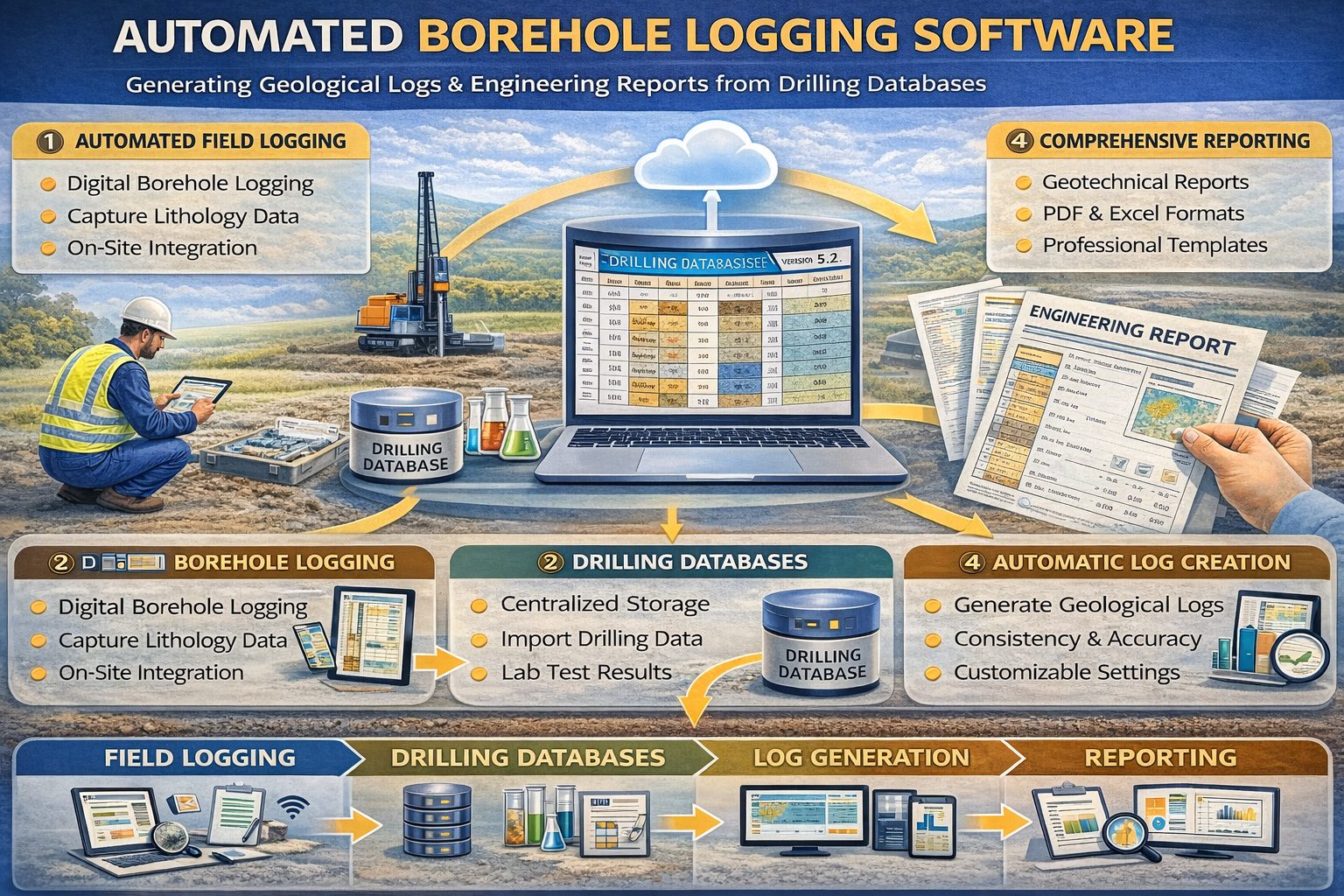
Traditionally, borehole logs were created manually using field notes and drafting tools. While this approach has been used for decades, modern drilling programs generate much larger datasets than in the past. Managing and presenting this information efficiently requires digital solutions. Today, many organizations are adopting automated borehole log generation systems that convert structured drilling data into standardized graphical logs and engineering reports.
Automated borehole logging tools improve data accuracy, reduce reporting time, and ensure consistent formatting across projects. By integrating drilling records, laboratory results, and groundwater measurements into centralized databases, these systems can automatically generate professional borehole logs and subsurface visualizations.
What is a Borehole Log?
A borehole log is a graphical and descriptive record of the subsurface conditions encountered during drilling. The log typically displays geological layers, sample depths, groundwater observations, and field test results along a vertical depth scale.
Typical components of a borehole log include:
- Borehole identification and location
- Drilling method and equipment
- Lithology descriptions
- Soil and rock classifications
- Sample depths and intervals
- Field test results
- Groundwater observations
These logs allow engineers and scientists to quickly understand the structure of subsurface layers and evaluate ground conditions.
Traditional Borehole Log Creation
In traditional workflows, borehole logs were created manually using paper field logs and drafting software. After drilling was completed, geologists would compile field notes and laboratory results into a final report.
This process typically involved several steps:
- Recording field observations during drilling
- Transcribing handwritten notes into digital formats
- Formatting lithology descriptions and sample intervals
- Creating graphical representations of soil layers
- Assembling the final borehole log report
While effective, this process was time‑consuming and prone to transcription errors.
What is Automated Borehole Log Generation?
Automated borehole log generation uses specialized software to transform drilling data stored in databases into formatted borehole logs automatically. Instead of manually drawing each log, engineers can generate logs instantly using structured datasets.
Automated systems pull information directly from borehole databases that store drilling logs, laboratory results, groundwater measurements, and sampling records. The software then converts this data into standardized graphical logs.
Automated logs typically include:
- Standardized lithology symbols
- Color-coded soil layers
- Sample depth indicators
- Groundwater markers
- Field test results
This automation significantly reduces the time required to prepare engineering reports.
Digital Borehole Databases
The foundation of automated borehole log generation is the use of centralized borehole databases. These databases store structured datasets describing subsurface conditions.
Typical borehole database records include:
- Borehole location coordinates
- Drilling logs
- Soil classifications
- Sampling intervals
- Laboratory analytical results
- Groundwater monitoring data
When data is stored in standardized formats, automated tools can retrieve and visualize the information instantly.
Benefits of Automated Borehole Logging
Faster Report Generation
Automated systems allow engineers to generate borehole logs in seconds rather than hours. This significantly reduces the time required to prepare site investigation reports.
Improved Data Accuracy
Because data is imported directly from databases, automation reduces the risk of transcription errors that may occur when manually copying field notes.
Consistent Formatting
Automated systems apply standardized templates for borehole logs. This ensures consistent formatting across projects and organizations.
Better Data Integration
Automated logging tools integrate multiple datasets such as laboratory results and groundwater measurements into a single graphical log.
Integration with GIS and 3D Modeling
Many modern borehole logging systems integrate with Geographic Information Systems (GIS). GIS integration allows borehole logs to be visualized on maps and connected to spatial datasets.
This integration supports:
- Borehole location mapping
- Geological cross sections
- Groundwater contour mapping
- 3D subsurface modeling
By combining borehole logs with GIS data, engineers can analyze subsurface conditions across large project areas.
Automated Cross Sections and Geological Models
In addition to individual borehole logs, automated systems can generate geological cross sections that connect multiple boreholes. Cross sections illustrate how subsurface layers extend between drilling locations.
Advanced visualization tools can also generate three-dimensional geological models. These models help engineers understand the spatial geometry of subsurface formations.
Applications in Engineering and Environmental Projects
Automated borehole log generation is widely used in several fields:
- Geotechnical engineering investigations
- Environmental site assessments
- Groundwater monitoring programs
- Mining exploration
- Infrastructure development
In each of these fields, automated tools help transform complex drilling datasets into clear visual documentation.
Future of Borehole Log Automation
Advances in digital technology continue to improve automated logging systems. Emerging technologies include:
- Cloud‑based borehole databases
- Mobile digital logging tools
- AI‑assisted geological interpretation
- Real‑time monitoring dashboards
These technologies will further streamline the process of collecting, managing, and visualizing subsurface data.
Conclusion
Automating borehole log generation is transforming how subsurface data is managed in geotechnical and environmental investigations. By integrating drilling logs, laboratory results, and groundwater monitoring data into centralized databases, modern software systems can automatically generate standardized borehole logs and engineering reports.
These tools improve efficiency, enhance data accuracy, and allow professionals to analyze complex subsurface conditions more effectively. As digital technologies continue to evolve, automated borehole logging will become an essential component of modern subsurface data management.
For a broader overview see the guide: The Complete Guide to Borehole Data Solutions.
Learn more about our Solutions
Related Articles
Explore additional articles in the Borehole Data Solutions series.
- What is Borehole Data? A Complete Introduction
- Types of Borehole Data Collected During Drilling
- Borehole Logging Explained: Methods, Tools, and Data
- Digital Borehole Logging vs Traditional Field Logs
- Borehole Database Systems: How They Work
- How Borehole Data Supports Geotechnical Engineering
- How Borehole Data Supports Environmental Site Assessments
- The Role of Borehole Data in Groundwater Monitoring
- Integrating Borehole Data with GIS Systems
- Borehole Data Standardization and Data Quality
- Borehole Data Visualization and Subsurface Modeling
- Best Practices for Borehole Data Management
- Centralizing Borehole Data Across Multiple Projects
- Cloud-Based Borehole Data Solutions
- Borehole Data Integration with Laboratory Data
- Borehole Data Management for Large Infrastructure Projects
- Choosing Borehole Data Management Software
- WinLoG Borehole Logging Software for Managing Drilling Data
- Subsurface Data Management for Engineering Projects
- How Engineering Firms Build Centralized Geological Databases
- The Future of Digital Subsurface Investigation Data