
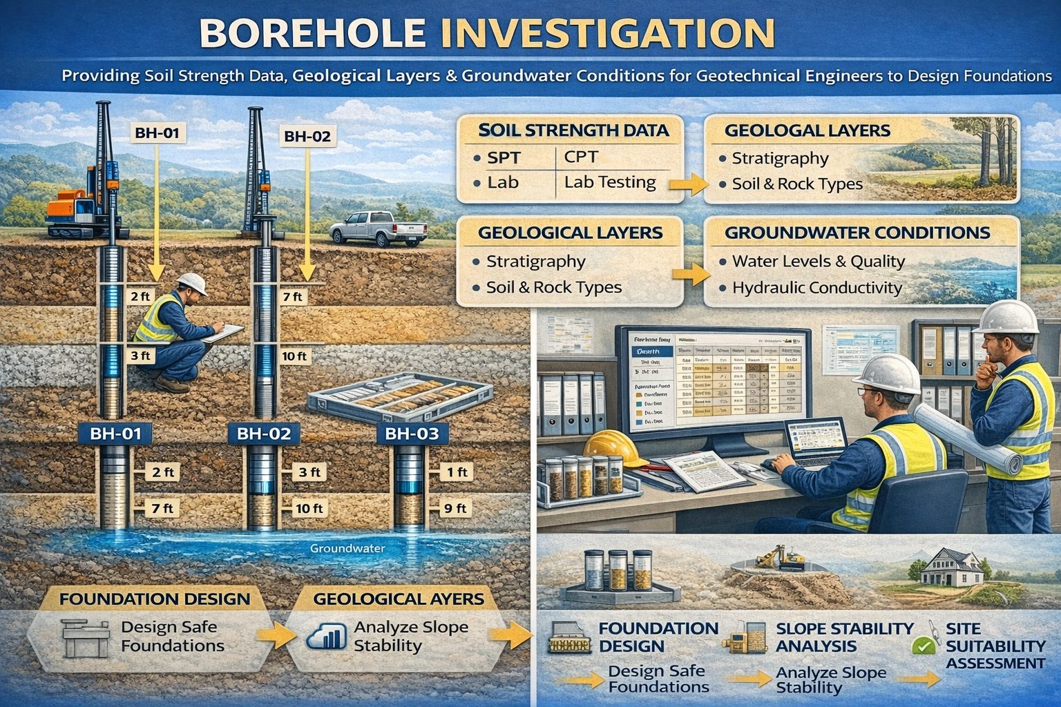
Geotechnical engineering relies heavily on understanding subsurface conditions before construction begins. Engineers must evaluate soil layers, rock formations, groundwater conditions, and material strength to ensure that buildings, roads, bridges, and other infrastructure are designed safely and efficiently. One of the most important sources of subsurface information is borehole data.
Borehole data is collected during drilling investigations and provides a detailed record of underground conditions. These records include drilling logs, soil classifications, laboratory test results, groundwater measurements, and other geotechnical observations. Modern geotechnical projects generate large volumes of this data, which is why many organizations rely on geotechnical borehole databases to store and manage drilling information.
These systems allow engineers and geologists to organize drilling logs, soil properties, laboratory analytical results, and subsurface data used in engineering investigations. By centralizing this information in structured databases, project teams can analyze subsurface conditions more efficiently and make better engineering decisions.
What is Borehole Data?
Borehole data refers to the geological, geotechnical, and environmental information collected during drilling investigations. When a borehole is drilled into the ground, soil and rock samples are retrieved and analyzed to determine the characteristics of subsurface materials.
The data collected during drilling provides a vertical profile of underground conditions. Each layer encountered during drilling is documented with its depth, material type, and physical properties.
Typical borehole data collected during geotechnical investigations includes:
- Lithology descriptions
- Soil classifications
- Depth intervals
- Sampling locations
- Groundwater measurements
- Field test results
- Laboratory test results
This information allows engineers to understand how subsurface materials will behave under load and how they may influence the design of structures.
Role of Borehole Data in Geotechnical Engineering
Geotechnical engineering focuses on analyzing soil and rock behavior to support safe construction. Borehole data provides the critical information needed to evaluate subsurface conditions.
Engineers use borehole data to determine:
- Soil strength and stability
- Foundation design requirements
- Groundwater conditions
- Slope stability
- Settlement potential
- Subsurface hazards
Without accurate borehole data, engineers would have limited information about the materials supporting a structure.
Drilling Logs and Lithology Data
Drilling logs are one of the most important components of geotechnical borehole data. A drilling log records the geological materials encountered during drilling along with the depth at which each layer occurs.
Geologists document lithology characteristics such as:
- Soil type
- Grain size
- Color
- Moisture content
- Rock hardness
- Degree of weathering
These descriptions allow engineers to identify subsurface stratigraphy and understand how geological layers vary across a project site.
Soil Classification and Engineering Properties
Soil classification is a critical part of geotechnical investigations. Engineers classify soils based on grain size distribution, plasticity, and other physical characteristics.
The Unified Soil Classification System (USCS) is widely used in geotechnical engineering. This system categorizes soils into groups such as:
- Clay
- Silt
- Sand
- Gravel
- Organic soils
Each soil type has unique engineering properties that influence how it behaves under load. For example, clay soils may compress under pressure while sandy soils may drain water quickly.
Geotechnical Field Testing
Field tests performed during drilling provide additional information about soil strength and density.
One of the most common field tests is the Standard Penetration Test (SPT). This test measures the resistance of soil to penetration and provides an estimate of soil density.
Other field tests may include:
- Cone Penetration Tests (CPT)
- Vane shear tests
- Pressuremeter tests
- Plate load tests
These measurements help engineers determine the bearing capacity of soils and evaluate foundation performance.
Laboratory Testing of Soil and Rock Samples
Samples collected during drilling are often sent to laboratories for detailed analysis. Laboratory tests provide precise measurements of soil and rock properties.
Common geotechnical laboratory tests include:
- Grain size analysis
- Atterberg limits
- Moisture content
- Shear strength testing
- Consolidation testing
These tests help engineers evaluate how soils will respond to loading, settlement, and environmental conditions.
Groundwater Data in Borehole Investigations
Groundwater conditions play an important role in geotechnical engineering. During drilling investigations, geologists record groundwater levels and observe any water inflow into the borehole.
Groundwater data may include:
- Depth to groundwater
- Aquifer conditions
- Hydraulic gradients
- Seasonal water level fluctuations
Groundwater conditions can significantly influence foundation design, excavation stability, and slope stability.
Geotechnical Borehole Databases
Modern engineering projects often involve hundreds or thousands of boreholes. Managing this information using paper records or spreadsheets can be challenging.
Geotechnical borehole databases provide centralized systems for storing and organizing drilling data. These databases allow engineers to manage large datasets and retrieve information quickly.
Typical features of borehole data management systems include:
- Centralized borehole databases
- Digital borehole logs
- Laboratory data import
- Groundwater monitoring records
- GIS integration
- Automated reporting tools
These systems allow engineers to analyze subsurface conditions across multiple projects and locations.
Integration with GIS and Geological Modeling
Borehole data is inherently spatial because each borehole represents a specific location within a site. Integrating borehole databases with Geographic Information Systems (GIS) allows engineers to visualize subsurface data on maps.
GIS integration enables:
- Borehole location mapping
- Geological cross sections
- 3D subsurface models
- Groundwater monitoring networks
These visualizations help engineers interpret complex subsurface conditions and communicate findings effectively.
Benefits of Digital Borehole Data Management
Digital borehole databases provide several advantages for geotechnical engineering projects.
- Improved data organization
- Faster analysis of subsurface conditions
- Reduced data entry errors
- Efficient report generation
- Better collaboration between project teams
Centralized databases ensure that valuable subsurface data remains accessible for future projects.
Conclusion
Borehole data is essential for geotechnical engineering investigations. Drilling logs, soil classifications, laboratory test results, and groundwater measurements provide the information needed to understand subsurface conditions.
Modern geotechnical borehole databases allow engineers to organize and analyze this data efficiently. By storing drilling logs, soil properties, laboratory results, and other subsurface information in centralized systems, engineers can make better decisions and design safer infrastructure.
As engineering projects continue to generate larger datasets, digital borehole data management systems will play an increasingly important role in geotechnical investigations and infrastructure development.
For a broader overview see the guide: The Complete Guide to Borehole Data Solutions.
Learn more about our Solutions
Related Articles
Explore additional articles in the Borehole Data Solutions series.
- What is Borehole Data? A Complete Introduction
- Types of Borehole Data Collected During Drilling
- Borehole Logging Explained: Methods, Tools, and Data
- Digital Borehole Logging vs Traditional Field Logs
- Borehole Database Systems: How They Work
- How Borehole Data Supports Environmental Site Assessments
- The Role of Borehole Data in Groundwater Monitoring
- Integrating Borehole Data with GIS Systems
- Borehole Data Standardization and Data Quality
- Borehole Data Visualization and Subsurface Modeling
- Best Practices for Borehole Data Management
- Centralizing Borehole Data Across Multiple Projects
- Automating Borehole Log Generation
- Cloud-Based Borehole Data Solutions
- Borehole Data Integration with Laboratory Data
- Borehole Data Management for Large Infrastructure Projects
- Choosing Borehole Data Management Software
- WinLoG Borehole Logging Software for Managing Drilling Data
- Subsurface Data Management for Engineering Projects
- How Engineering Firms Build Centralized Geological Databases
- The Future of Digital Subsurface Investigation Data