
Subsurface investigations generate large volumes of information about geological formations, soil properties, groundwater conditions, and environmental contamination. During drilling programs, engineers and scientists collect soil and groundwater samples from boreholes and send them to laboratories for detailed analysis. The results of these analyses are essential for understanding the physical, chemical, and environmental characteristics of subsurface materials.
Integrating borehole data with laboratory analytical results is a critical step in modern geotechnical and environmental investigations. When laboratory results are connected directly to borehole logs and sampling records, engineers and environmental professionals gain a more complete understanding of subsurface conditions. This integration allows organizations to manage drilling datasets more efficiently, improve data quality, and generate accurate engineering and environmental reports.
This article explores how borehole data and laboratory data are integrated, the types of laboratory tests commonly used in subsurface investigations, and the benefits of using centralized databases to manage drilling and analytical datasets.
Understanding Borehole Data
Borehole data refers to the geological, geotechnical, and environmental information collected during drilling investigations. As drilling progresses, geologists and engineers record observations about the materials encountered below the ground surface.
Typical borehole datasets include:
- Drilling logs and lithology descriptions
- Soil and rock classifications
- Sampling intervals and depths
- Groundwater observations
- Geotechnical field test results
- Monitoring well construction details
Each borehole provides a vertical profile of subsurface conditions. However, field observations alone are not always sufficient to fully characterize soil and groundwater properties. Laboratory testing provides the detailed analytical data needed to evaluate engineering and environmental conditions.
Role of Laboratory Testing in Subsurface Investigations
Laboratory testing allows scientists and engineers to measure the physical and chemical properties of soil, rock, and groundwater samples. These tests provide precise data that cannot be obtained through field observations alone.
Laboratory results are essential for several types of investigations:
- Geotechnical engineering studies
- Environmental site assessments
- Groundwater monitoring programs
- Mining exploration
- Infrastructure development projects
By combining borehole observations with laboratory analytical results, professionals can develop a more accurate understanding of subsurface environments.
Common Types of Geotechnical Laboratory Tests
Geotechnical laboratory tests evaluate the engineering properties of soils and rocks. These tests help engineers determine how subsurface materials will behave under load.
Common geotechnical laboratory tests include:
- Grain size distribution analysis
- Atterberg limits testing
- Moisture content determination
- Shear strength testing
- Consolidation testing
- Permeability testing
These tests provide critical information for designing building foundations, slopes, retaining structures, and other infrastructure projects.
Environmental Laboratory Analysis
Environmental investigations focus on detecting contaminants in soil and groundwater. Laboratory testing identifies the presence and concentration of chemical pollutants.
Environmental laboratory analyses commonly measure:
- Petroleum hydrocarbons
- Volatile organic compounds (VOCs)
- Semi-volatile organic compounds (SVOCs)
- Heavy metals
- Nutrients
- Industrial chemicals
These analyses are critical for environmental site assessments and remediation planning.
Groundwater Laboratory Testing
Groundwater monitoring programs frequently require laboratory analysis of water samples collected from monitoring wells installed in boreholes.
Groundwater laboratory tests may evaluate:
- Chemical contaminants
- Dissolved metals
- Nutrient concentrations
- Water chemistry parameters
- Microbial indicators
These datasets help hydrogeologists understand groundwater quality and track contamination trends over time.
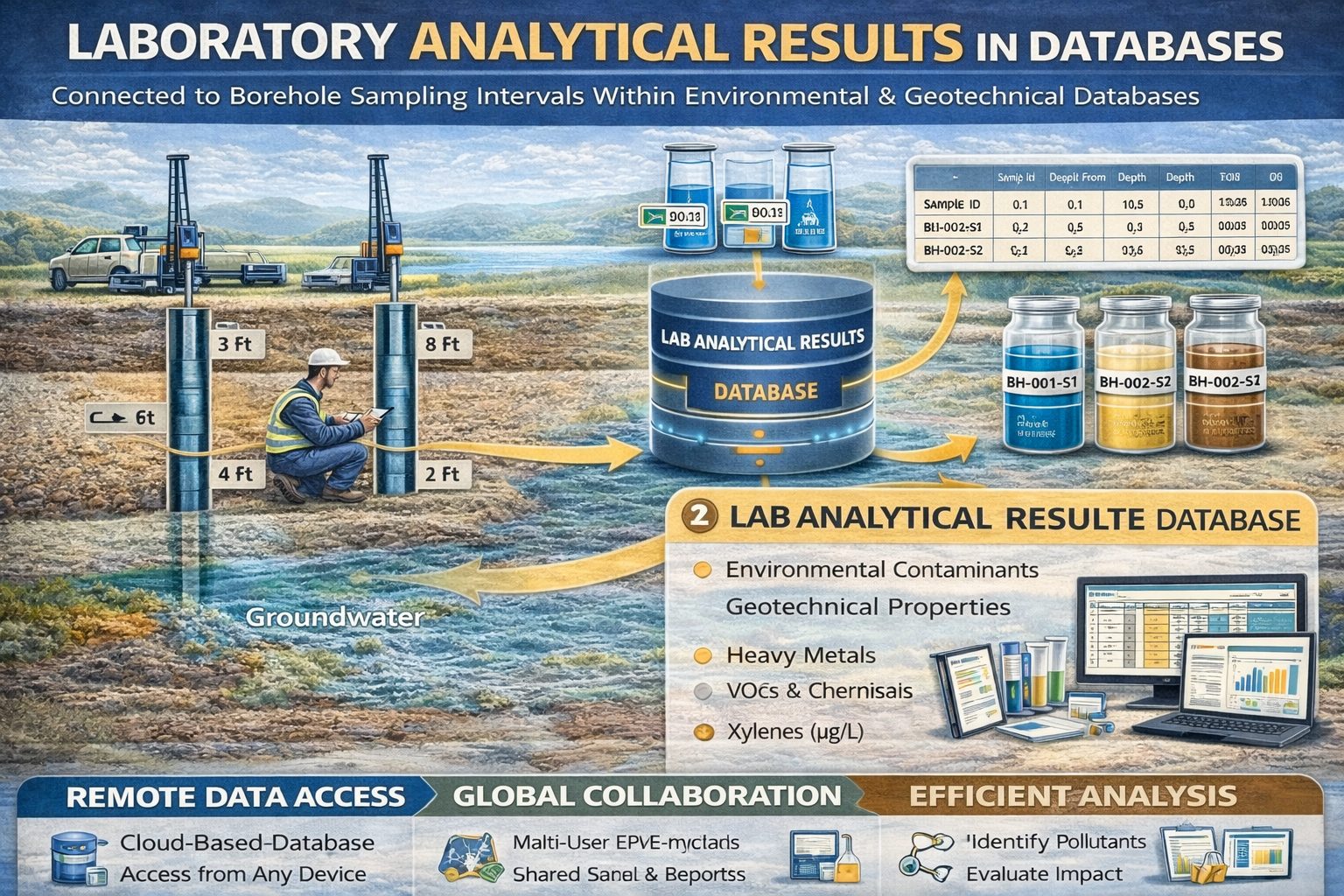
Linking Laboratory Results to Borehole Samples
For laboratory data to be useful, it must be accurately linked to the borehole and sampling interval from which the sample was collected. Each soil or groundwater sample is assigned a unique sample identification number during drilling.
Laboratory reports reference these sample IDs so that analytical results can be connected to the correct borehole location and depth.
Typical sample information recorded in borehole databases includes:
- Borehole identification
- Sample ID
- Sampling depth
- Sampling method
- Date of collection
By linking laboratory results to these records, engineers and environmental scientists can analyze subsurface conditions accurately.
Electronic Data Deliverables (EDDs)
Modern laboratories often provide analytical results in digital formats known as Electronic Data Deliverables (EDDs). These standardized files allow laboratory data to be imported directly into borehole databases.
EDD integration reduces manual data entry and minimizes transcription errors. Once imported, laboratory results can be automatically linked to borehole records, monitoring wells, and sampling events.
Centralized Borehole Data Management Systems
Many organizations use centralized borehole data management systems to store drilling logs, laboratory results, and monitoring records in structured databases.
These systems allow users to:
- Store borehole and sampling records
- Import laboratory analytical results
- Track groundwater monitoring data
- Generate geological visualizations
- Create environmental reports
Centralized databases ensure that drilling and laboratory datasets remain organized and accessible across projects.
Benefits of Borehole and Laboratory Data Integration
Improved Data Accuracy
Automated data import reduces transcription errors and ensures that laboratory results are correctly associated with sampling locations.
Faster Data Analysis
Integrated datasets allow engineers and scientists to analyze drilling and laboratory data together without manually compiling reports.
Enhanced Environmental Monitoring
Combining borehole logs with groundwater analytical results allows professionals to track contamination trends and identify environmental risks.
Efficient Reporting
Integrated systems can automatically generate charts, cross sections, and monitoring reports based on stored datasets.
Integration with GIS and Visualization Tools
Borehole and laboratory data can also be integrated with Geographic Information Systems (GIS). GIS platforms allow analytical results to be mapped spatially across a site.
GIS visualization supports:
- Contaminant plume mapping
- Groundwater quality mapping
- Soil contamination visualization
- Regional geological analysis
These visual tools help professionals interpret complex datasets and communicate findings effectively.
Future Trends in Laboratory Data Integration
As digital technologies evolve, new tools are improving how borehole and laboratory datasets are managed. Emerging trends include cloud-based data platforms, automated data validation systems, and advanced subsurface visualization tools.
These technologies will allow organizations to analyze larger datasets and gain deeper insights into subsurface environments.
Conclusion
Integrating borehole data with laboratory analytical results is essential for understanding subsurface conditions in geotechnical engineering, environmental investigations, and groundwater monitoring programs. By linking drilling records with laboratory data, organizations can develop comprehensive datasets that support accurate analysis and reporting.
Modern borehole data management systems make it possible to integrate laboratory results automatically, improving data accuracy and efficiency. As subsurface investigations continue to generate larger datasets, integrated borehole and laboratory data systems will become increasingly important for managing and analyzing environmental and geological information.
For a broader overview see the guide: The Complete Guide to Borehole Data Solutions.
Learn more about our Solutions
Related Articles
Explore additional articles in the Borehole Data Solutions series.
- What is Borehole Data? A Complete Introduction
- Types of Borehole Data Collected During Drilling
- Borehole Logging Explained: Methods, Tools, and Data
- Digital Borehole Logging vs Traditional Field Logs
- Borehole Database Systems: How They Work
- How Borehole Data Supports Geotechnical Engineering
- How Borehole Data Supports Environmental Site Assessments
- The Role of Borehole Data in Groundwater Monitoring
- Integrating Borehole Data with GIS Systems
- Borehole Data Standardization and Data Quality
- Borehole Data Visualization and Subsurface Modeling
- Best Practices for Borehole Data Management
- Centralizing Borehole Data Across Multiple Projects
- Automating Borehole Log Generation
- Cloud-Based Borehole Data Solutions
- Borehole Data Management for Large Infrastructure Projects
- Choosing Borehole Data Management Software
- WinLoG Borehole Logging Software for Managing Drilling Data
- Subsurface Data Management for Engineering Projects
- How Engineering Firms Build Centralized Geological Databases
- The Future of Digital Subsurface Investigation Data