
Large infrastructure projects such as highways, railways, bridges, tunnels, dams, airports, and energy facilities require detailed knowledge of subsurface conditions. Engineers must understand soil layers, rock formations, groundwater systems, and geotechnical properties before designing foundations and structural systems. One of the most important sources of this information is borehole data collected during geotechnical site investigations.
During infrastructure planning and construction, drilling programs generate enormous volumes of subsurface data. Borehole logs, soil classifications, groundwater measurements, laboratory test results, and monitoring records must all be carefully organized and analyzed. Managing this information effectively is essential for ensuring that engineering designs are based on accurate and reliable subsurface data.
Borehole data management systems provide the tools needed to store, organize, analyze, and visualize drilling data collected during large infrastructure investigations. These systems help engineering teams coordinate drilling programs, manage laboratory results, and maintain long‑term records of subsurface conditions across complex projects.
The Role of Borehole Investigations in Infrastructure Projects
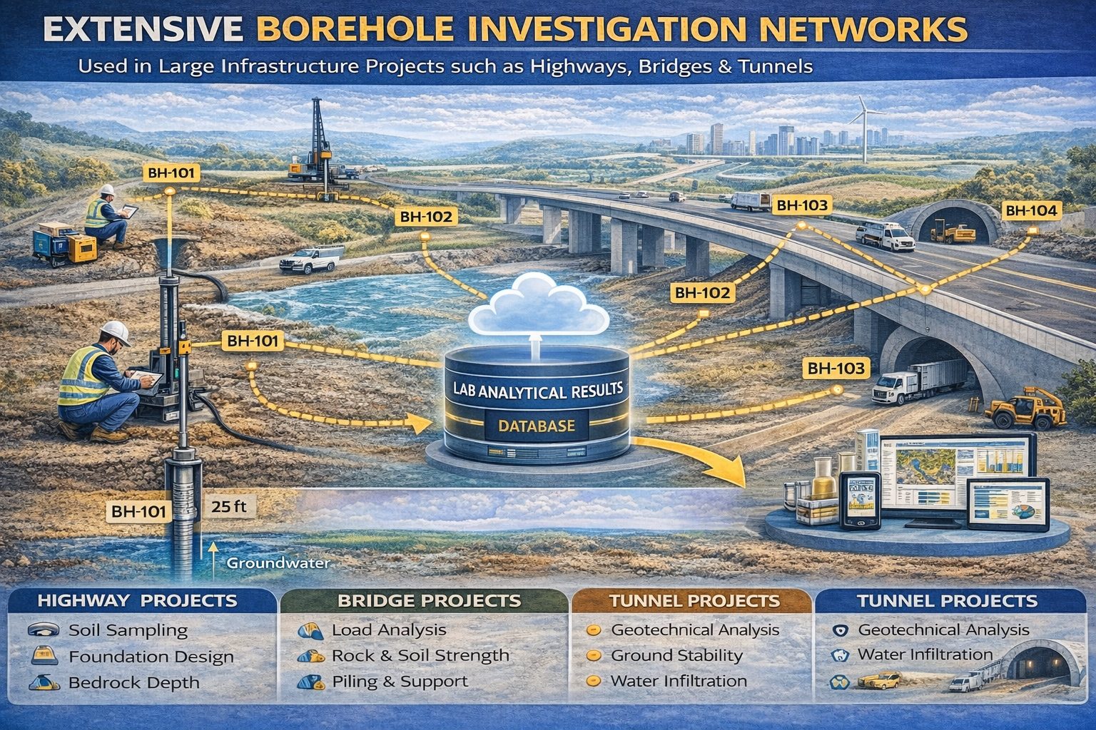
Before construction begins on major infrastructure projects, geotechnical engineers conduct site investigations to understand ground conditions. These investigations typically involve drilling boreholes at multiple locations across the project area.
Boreholes allow engineers to examine subsurface conditions and collect samples for laboratory testing. The information gathered during drilling programs helps engineers evaluate soil strength, rock stability, groundwater conditions, and potential geotechnical hazards.
Infrastructure projects often require dozens or even hundreds of boreholes, depending on the size and complexity of the project. Managing the data generated by these investigations requires structured systems capable of handling large datasets.
Types of Borehole Data Collected During Infrastructure Investigations
Borehole investigations generate a wide range of subsurface datasets. These records provide the information engineers need to design safe and reliable infrastructure systems.
Common types of borehole data include:
- Drilling logs and lithology descriptions
- Soil classifications and rock properties
- Sampling intervals and depths
- Standard Penetration Test (SPT) results
- Cone Penetration Test (CPT) measurements
- Groundwater observations
- Laboratory geotechnical test results
Each borehole provides a vertical profile of subsurface conditions at a specific location. When combined across many drilling locations, these datasets allow engineers to develop a comprehensive understanding of ground conditions.
Challenges of Managing Borehole Data in Large Projects
Large infrastructure projects often involve multiple contractors, engineering teams, laboratories, and monitoring programs. Managing the data generated by these activities can be challenging without structured systems.
Common data management challenges include:
- Large volumes of drilling and laboratory data
- Inconsistent data formats across contractors
- Difficulty accessing historical investigation records
- Coordination between multiple engineering teams
- Ensuring long‑term preservation of subsurface datasets
Without proper management systems, valuable investigation data may become fragmented or difficult to analyze.
Borehole Data Management Systems
Borehole data management systems are specialized databases designed to store and organize subsurface investigation records. These systems provide centralized platforms where drilling logs, sampling data, laboratory results, and groundwater monitoring records can be stored and accessed.
Key features of borehole data management systems include:
- Centralized borehole databases
- Standardized data structures
- Laboratory data import tools
- Groundwater monitoring tracking
- Visualization and reporting tools
By using centralized systems, engineering teams can maintain consistent datasets across multiple phases of an infrastructure project.
Supporting Geotechnical Engineering Analysis
Geotechnical engineers rely on borehole data to evaluate soil strength, settlement potential, and foundation stability. Borehole databases allow engineers to quickly access drilling records and laboratory test results when performing engineering analysis.
Examples of geotechnical analyses supported by borehole data include:
- Foundation design
- Slope stability analysis
- Settlement calculations
- Tunnel design
- Earth retaining structure design
Having organized and accessible borehole datasets allows engineers to evaluate ground conditions more efficiently.
Groundwater Monitoring in Infrastructure Projects
Groundwater conditions are a critical consideration for many infrastructure projects. High groundwater levels can influence excavation methods, foundation design, and long‑term structural stability.
Boreholes are often converted into monitoring wells that allow engineers to measure groundwater levels over time. These monitoring programs generate datasets that track groundwater fluctuations during and after construction.
Borehole data management systems help track monitoring wells, groundwater measurements, and water quality data collected during long‑term monitoring programs.
Laboratory Testing Integration
Laboratory testing is an essential part of geotechnical investigations. Soil and rock samples collected from boreholes are analyzed in laboratories to determine engineering properties.
Typical laboratory tests include:
- Grain size analysis
- Atterberg limits testing
- Moisture content determination
- Shear strength testing
- Consolidation testing
Borehole data management systems allow laboratory results to be linked directly to the borehole samples from which they were collected. This integration ensures that analytical results remain connected to the correct sampling locations.
Integration with GIS and Spatial Analysis
Large infrastructure projects often extend across wide geographic areas. Integrating borehole data with Geographic Information Systems (GIS) allows engineers to visualize subsurface conditions across the project corridor.
GIS integration supports:
- Borehole location mapping
- Geological cross‑section generation
- Groundwater contour mapping
- Subsurface modeling
Spatial visualization tools help engineering teams interpret large datasets and identify patterns in subsurface conditions.
Visualization and Reporting Tools
Modern borehole data management systems often include tools for generating visual representations of subsurface conditions. These tools help engineers interpret drilling data and communicate findings in technical reports.
Common visualization tools include:
- Borehole logs
- Geological cross sections
- 3D subsurface models
- Groundwater monitoring charts
- Engineering dashboards
These visualizations make it easier for project teams and stakeholders to understand complex geological conditions.
Collaboration Across Project Teams
Large infrastructure projects involve collaboration between geologists, geotechnical engineers, environmental scientists, and construction teams. Centralized borehole data systems allow these teams to access shared datasets.
This collaborative environment improves communication and ensures that all teams are working with the same information when making engineering decisions.
Long‑Term Data Preservation
Infrastructure assets often remain in service for decades. Maintaining long‑term records of subsurface investigations can be valuable for future maintenance, upgrades, and expansion projects.
Borehole data management systems allow organizations to preserve historical drilling records in structured databases that remain accessible for future engineering studies.
Future Trends in Infrastructure Data Management
Advances in digital technology are transforming how infrastructure investigation data is managed. Emerging trends include cloud‑based data platforms, automated borehole log generation, and advanced 3D geological modeling.
These technologies allow engineering teams to analyze larger datasets and develop more accurate subsurface models.
Conclusion
Borehole data plays a critical role in the planning, design, and construction of large infrastructure projects. Managing the extensive datasets generated during drilling investigations requires specialized data management systems capable of organizing drilling logs, laboratory results, groundwater monitoring data, and geotechnical records.
By implementing centralized borehole data management systems, engineering organizations can improve collaboration, enhance data quality, and support more informed engineering decisions. As infrastructure projects continue to grow in complexity, effective borehole data management will remain an essential component of modern geotechnical engineering.
For a broader overview see the guide: The Complete Guide to Borehole Data Solutions.
Learn more about our Solutions
Related Articles
Explore additional articles in the Borehole Data Solutions series.
- What is Borehole Data? A Complete Introduction
- Types of Borehole Data Collected During Drilling
- Borehole Logging Explained: Methods, Tools, and Data
- Digital Borehole Logging vs Traditional Field Logs
- Borehole Database Systems: How They Work
- How Borehole Data Supports Geotechnical Engineering
- How Borehole Data Supports Environmental Site Assessments
- The Role of Borehole Data in Groundwater Monitoring
- Integrating Borehole Data with GIS Systems
- Borehole Data Standardization and Data Quality
- Borehole Data Visualization and Subsurface Modeling
- Best Practices for Borehole Data Management
- Centralizing Borehole Data Across Multiple Projects
- Automating Borehole Log Generation
- Cloud-Based Borehole Data Solutions
- Borehole Data Integration with Laboratory Data
- Choosing Borehole Data Management Software
- WinLoG Borehole Logging Software for Managing Drilling Data
- Subsurface Data Management for Engineering Projects
- How Engineering Firms Build Centralized Geological Databases
- The Future of Digital Subsurface Investigation Data