
Subsurface investigations play a critical role in engineering, environmental science, mining, and groundwater studies. Before constructing buildings, highways, pipelines, or remediation systems, engineers and geologists must understand what lies beneath the ground surface. One of the most important sources of subsurface information is borehole data.
Borehole data refers to the geological, geotechnical, and environmental information collected during drilling investigations. These records describe soil layers, rock formations, groundwater conditions, and sampling intervals encountered during drilling. By analyzing borehole data, scientists and engineers can understand the composition, structure, and behavior of subsurface materials.
Borehole data is essential for site investigations, foundation design, groundwater monitoring, contamination studies, and mineral exploration. Without accurate borehole data, it would be extremely difficult to assess subsurface conditions and make informed decisions about construction or environmental management.
Understanding Borehole Data
A borehole is a narrow hole drilled into the ground to investigate subsurface conditions. Boreholes are created using drilling equipment such as augers, rotary drilling rigs, or sonic drilling systems. As drilling progresses, geologists and technicians record observations about the materials encountered beneath the surface.
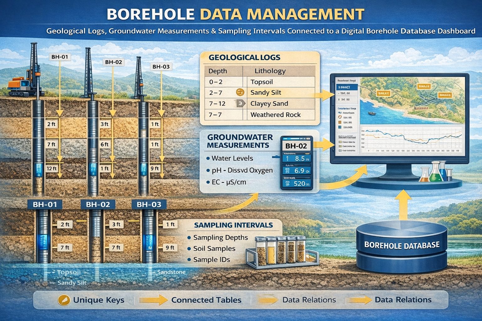
The information gathered during drilling forms what is known as borehole data. This dataset typically includes:
- Soil and rock descriptions
- Lithology logs
- Depth intervals
- Groundwater levels
- Sampling locations
- Geotechnical test results
- Laboratory analytical data
Borehole data provides a vertical profile of subsurface conditions, allowing scientists and engineers to understand how geological layers change with depth.
How Borehole Data is Collected
Site Investigation Planning
Before drilling begins, engineers and geologists design a drilling program based on project objectives. They determine borehole locations, target depths, sampling intervals, and required laboratory tests.
Drilling Operations
A drilling rig advances the borehole into the ground using methods such as hollow-stem auger drilling, rotary drilling, sonic drilling, or diamond core drilling.
Geological Logging
Geologists examine soil and rock samples retrieved from the borehole and record descriptions including soil type, grain size, color, texture, and rock weathering characteristics.
Sampling and Testing
Samples collected during drilling may be analyzed for grain size distribution, Atterberg limits, rock strength, or chemical contaminants.
Groundwater Measurements
When groundwater is encountered, technicians measure water levels and aquifer conditions. Some boreholes are converted into monitoring wells for long‑term groundwater monitoring.
Types of Borehole Data
Geological Data
Geological borehole data describes natural materials encountered during drilling, including soil layers, sediment types, and rock formations.
Geotechnical Data
Geotechnical data focuses on engineering properties such as Standard Penetration Test results, shear strength, density, and bearing capacity.
Environmental Data
Environmental borehole investigations collect soil and groundwater samples to identify contamination and evaluate environmental conditions.
Hydrogeological Data
Hydrogeological borehole data includes groundwater elevations, aquifer thickness, hydraulic gradients, and pumping test results.
Borehole Logs: The Core Record of Borehole Data
A borehole log is the primary document used to record borehole data. It typically includes borehole location, drilling method, lithology descriptions, sample intervals, and groundwater observations.
Borehole logs are often presented as vertical diagrams showing the sequence of subsurface layers encountered during drilling.
How Borehole Data is Stored and Managed
Modern investigations generate large volumes of borehole data. Many organizations use digital borehole databases to store drilling logs, laboratory results, groundwater monitoring records, and geotechnical data.
These systems allow users to organize borehole datasets, visualize subsurface conditions, generate reports, and integrate borehole information with geographic information systems.
Applications of Borehole Data
Geotechnical Engineering
Engineers use borehole data to evaluate soil and rock conditions for buildings, bridges, highways, tunnels, and other infrastructure projects.
Environmental Site Investigations
Boreholes are used to collect soil and groundwater samples to assess contamination and monitor environmental remediation programs.
Mining and Mineral Exploration
Exploration drilling programs generate borehole data used to identify mineral deposits and estimate resource potential.
Groundwater and Hydrogeology
Hydrogeologists use borehole data to understand aquifers, groundwater flow systems, and water supply resources.
Conclusion
Borehole data is one of the most valuable sources of information about the subsurface environment. These records describe soil layers, rock formations, groundwater conditions, and sampling intervals encountered during drilling investigations.
By carefully collecting, managing, and analyzing borehole data, engineers and scientists can better understand subsurface conditions and make informed decisions for construction, environmental protection, and resource development.
For a broader overview see the guide: The Complete Guide to Borehole Data Solutions.
Learn more about our Solutions
Related Articles
Explore additional articles in the Borehole Data Solutions series.
- Types of Borehole Data Collected During Drilling
- Borehole Logging Explained: Methods, Tools, and Data
- Digital Borehole Logging vs Traditional Field Logs
- Borehole Database Systems: How They Work
- How Borehole Data Supports Geotechnical Engineering
- How Borehole Data Supports Environmental Site Assessments
- The Role of Borehole Data in Groundwater Monitoring
- Integrating Borehole Data with GIS Systems
- Borehole Data Standardization and Data Quality
- Borehole Data Visualization and Subsurface Modeling
- Best Practices for Borehole Data Management
- Centralizing Borehole Data Across Multiple Projects
- Automating Borehole Log Generation
- Cloud-Based Borehole Data Solutions
- Borehole Data Integration with Laboratory Data
- Borehole Data Management for Large Infrastructure Projects
- Choosing Borehole Data Management Software
- WinLoG Borehole Logging Software for Managing Drilling Data
- Subsurface Data Management for Engineering Projects
- How Engineering Firms Build Centralized Geological Databases
- The Future of Digital Subsurface Investigation Data