
Introduction
Geotechnical investigations generate large amounts of subsurface data. Every drilling program produces borehole logs, soil classifications, laboratory test results, groundwater measurements, and geological observations. Historically, much of this information was recorded on paper logs and manually transferred into reports or engineering drawings.
While traditional workflows were effective for smaller projects, modern infrastructure, environmental, and resource exploration projects often involve hundreds or thousands of boreholes. Managing this volume of information using manual processes can be inefficient and prone to errors.
Digital workflows have transformed how geotechnical data is collected, stored, analyzed, and visualized. By integrating borehole databases, geological modeling software, and digital visualization tools, engineers and geologists can efficiently convert raw field data into meaningful subsurface interpretations.
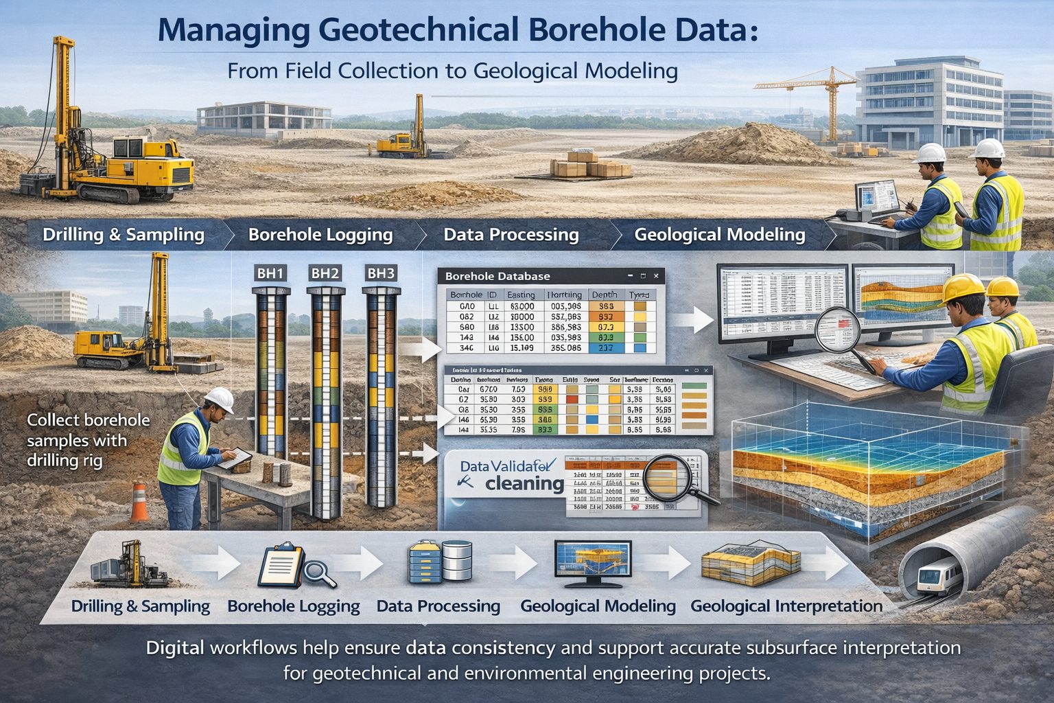
A digital geotechnical workflow typically begins in the field with borehole logging and continues through database management, quality control, geological interpretation, and three-dimensional modeling.
This article explains how digital workflows are used to manage borehole data, the benefits of modern data management systems, and the best practices for building efficient geotechnical data pipelines.
The Evolution of Geotechnical Data Management
Geotechnical data management has evolved significantly over the past several decades.
In the past, borehole information was typically recorded on paper logs during drilling operations. These logs included hand-written descriptions of soil layers, sample depths, and groundwater observations.
Once drilling was completed, the information was transferred into engineering reports, cross-sections, and geological interpretations. This process often required manual drafting and repeated transcription of data.
Manual workflows introduced several challenges:
- transcription errors
- inconsistent lithology descriptions
- difficulty managing large datasets
- limited ability to update interpretations
As computer technology advanced, geotechnical professionals began storing borehole logs in spreadsheets and digital databases. This shift allowed engineers to organize borehole information more efficiently and integrate it with mapping and modeling software.
Today, digital workflows enable seamless data transfer between field logging systems, centralized databases, and geological modeling platforms.
Components of a Digital Geotechnical Workflow
A typical digital workflow for geotechnical data consists of several stages, each responsible for transforming raw field data into usable geological information.
Field Data Collection
The first stage of the workflow occurs during drilling operations. Geologists or drilling technicians record observations about soil and rock layers encountered during drilling.
These observations typically include:
- lithology descriptions
- depth intervals
- sample collection depths
- groundwater observations
Modern field logging systems may use tablets or specialized software to record this information digitally in real time.
Digital logging reduces transcription errors and allows borehole data to be transferred directly into central databases.
Borehole Database Storage
Once borehole data has been collected, it must be stored in a structured database.
Borehole databases organize geological information into standardized tables that allow engineers and geologists to manage large datasets efficiently.
Typical database components include:
- borehole collar information
- lithology intervals
- laboratory test results
- groundwater measurements
By storing borehole data in structured databases, organizations can ensure that information remains consistent and accessible across multiple projects.
Data Validation and Quality Control
Before borehole data is used in geological interpretation, it should undergo quality control checks.
These checks help identify common errors such as:
- incorrect coordinates
- overlapping depth intervals
- inconsistent lithology descriptions
- missing borehole identifiers
Automated validation tools can detect many of these issues quickly.
Quality control is essential for maintaining the reliability of geological interpretations and engineering analyses.
Geological Interpretation
After borehole data has been validated, geologists can begin interpreting subsurface conditions.
This stage often involves generating geological cross-sections that connect layers between boreholes.
Geologists analyze lithology descriptions, stratigraphic relationships, and regional geology to determine how geological layers extend across the site.
Digital visualization tools allow geologists to view borehole logs, cross-sections, and maps simultaneously, making it easier to identify patterns in the data.
Subsurface Modeling
The final stage of the workflow involves constructing subsurface models based on the interpreted geological layers.
These models may include:
- cross-sections
- fence diagrams
- three-dimensional geological models
Subsurface models allow engineers to visualize the geometry of geological layers and evaluate how they may affect infrastructure design or environmental processes.
Advantages of Digital Workflows
Digital workflows provide several advantages over traditional paper-based methods.
One of the most significant benefits is improved efficiency. Digital systems allow borehole data to be entered once and reused across multiple applications.
For example, the same borehole database can be used to generate cross-sections, create geological maps, and produce engineering reports.
Digital workflows also reduce the risk of transcription errors. Because data is recorded electronically and transferred directly into databases, there are fewer opportunities for mistakes during data entry.
Another advantage is improved collaboration. Digital databases allow multiple team members to access and analyze borehole data simultaneously.
This capability is particularly valuable for large projects involving geologists, engineers, environmental scientists, and planners.
Integrating Borehole Databases with Geological Software
Modern geological software platforms rely heavily on borehole databases.
Instead of manually drawing cross-sections, engineers can import borehole data directly into modeling software.
These programs can automatically generate visualizations such as:
- geological cross-sections
- fence diagrams
- stratigraphic models
By linking borehole databases to modeling software, geologists can quickly update interpretations when new data becomes available.
This integration allows subsurface models to evolve as site investigations progress.
Cloud-Based Geotechnical Data Systems
Many organizations are now adopting cloud-based systems for managing geotechnical data.
Cloud platforms allow borehole databases to be stored on remote servers rather than local computers. This approach offers several advantages.
First, cloud systems allow project teams to access borehole data from multiple locations. Engineers working in different offices can collaborate using the same dataset.
Second, cloud platforms provide automatic data backups, reducing the risk of losing valuable geological information.
Finally, cloud systems can support real-time data updates, allowing new borehole information to be integrated into geological models immediately.
Automation in Geological Data Processing
Automation is becoming increasingly important in digital geotechnical workflows.
Automated tools can perform tasks such as:
- standardizing lithology descriptions
- detecting database errors
- generating cross-sections
- calculating layer volumes
Automation reduces the amount of manual work required to manage large borehole datasets.
However, automated interpretations should always be reviewed by experienced geologists to ensure that geological reasoning is applied correctly.
Challenges in Digital Data Workflows
Although digital workflows provide many advantages, they also introduce new challenges.
One challenge involves data standardization. If borehole logs are recorded using inconsistent terminology or formats, it can be difficult to integrate them into centralized databases.
Another challenge involves data compatibility between different software platforms. Some geological software programs use proprietary data formats that may not easily integrate with other systems.
Organizations must therefore establish standardized data structures and workflows to ensure compatibility across different tools.
Training is also important. Engineers and geologists must understand how to use digital systems effectively in order to maximize their benefits.
Best Practices for Digital Geotechnical Data Management
Several best practices can help organizations build efficient digital workflows for geotechnical data.
First, establish standardized borehole logging procedures to ensure consistent data collection in the field.
Second, store borehole data in structured databases rather than scattered spreadsheets or documents.
Third, implement automated quality control checks to identify data errors early in the workflow.
Fourth, integrate borehole databases with geological modeling software to streamline interpretation processes.
Finally, provide training to ensure that engineers and geologists understand how to use digital tools effectively.
The Future of Digital Geotechnical Workflows
The future of geotechnical data management will likely involve even greater integration between databases, modeling software, and real-time monitoring systems.
Emerging technologies such as digital twins may allow engineers to maintain continuously updated models of subsurface conditions throughout the lifecycle of infrastructure projects.
Artificial intelligence and machine learning may also play a role in analyzing large geological datasets and identifying patterns that may not be immediately obvious to human interpreters.
Although technology will continue to evolve, the fundamental principles of geological interpretation will remain essential.
Conclusion
Digital workflows have transformed how geotechnical data is collected, managed, and interpreted. By integrating field logging systems, borehole databases, and geological modeling software, engineers and geologists can efficiently convert raw drilling data into meaningful subsurface models.
These workflows improve efficiency, reduce data errors, and support collaboration among project teams. As infrastructure and environmental projects become more complex, digital geotechnical workflows will play an increasingly important role in managing subsurface information.
By adopting standardized data structures, implementing quality control procedures, and integrating digital tools into their workflows, organizations can build reliable systems for managing borehole data and interpreting subsurface geology.
Learn more about our Solutions
- GaeaSynergy Platform for Geoscientific Analysis
- WinLoG Borehole and Well Log Data Management
- WinFence Cross-section and Fence Diagram Visualization
Related Articles
- Geological Cross-Sections from Borehole Data: A Complete Engineering Guide
- Geological Modeling Software and Tools: Digital Platforms for Subsurface Interpretation
- Common Mistakes When Creating Geological Cross-Sections from Borehole Data
- How Borehole Spacing Affects Geological Cross-Section Accuracy
- Preparing Borehole Databases for Cross-Section Software
- How Lithological Correlation Works Between Boreholes
- Understanding Fence Diagrams in Geological Modeling
- Common Data Errors in Borehole Databases and How to Fix Them
- Using Geological Cross-Sections in Geotechnical Engineering
- Borehole Coordinate Systems and Mapping for Geological Modeling
- Depth vs Elevation in Borehole Databases for Geological Modeling
- Interpreting Geological Variability Between Boreholes
- Building Geological Cross-Sections from Borehole Data: A Step-by-Step Workflow
- How Geological Software Interpolates Subsurface Layers Between Boreholes
- Borehole Data Visualization Techniques for Geological Modeling
- Managing Large Borehole Data Sets in Engineering Projects
- Understanding Pinch-Outs and Missing Geological Layers in Subsurface Interpretation