
Introduction
Groundwater contamination is a major environmental concern that can impact drinking water supplies, ecosystems, and public health. Pollutants released from industrial sites, landfills, agricultural operations, and accidental chemical spills can migrate through soil and aquifers, forming contaminant plumes that may persist for decades. Understanding how these contaminants move through the subsurface is essential for environmental protection and effective remediation.
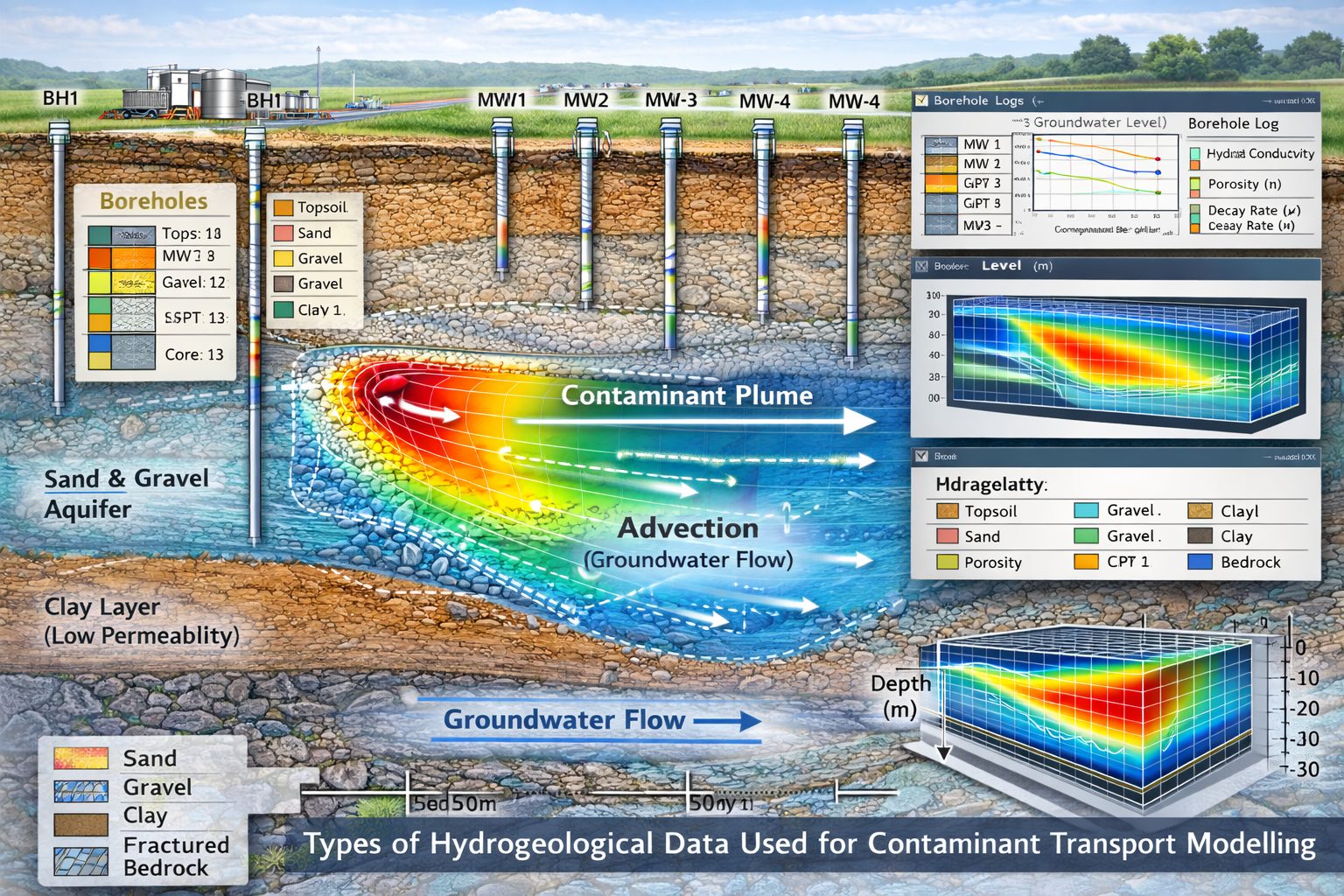
One of the most powerful tools used to analyze and predict contaminant migration is contaminant transport modelling. These models simulate the movement of pollutants through groundwater systems by combining groundwater flow simulations with physical and chemical transport processes. However, the accuracy of these models depends heavily on the quality and completeness of the hydrogeological data used to build them.
Hydrogeological data describe the geological structure, hydraulic properties, groundwater conditions, and contaminant characteristics of a site. This information allows environmental engineers and hydrogeologists to create realistic models that represent how water and contaminants move through the subsurface.
This article explores the types of hydrogeological data required for contaminant transport models, how these data are collected, and why accurate data are essential for reliable environmental predictions.
Why Hydrogeological Data Are Critical for Transport Models
Contaminant transport models rely on mathematical equations that describe groundwater flow and contaminant movement. However, these equations must be parameterized using real-world site data in order to produce meaningful predictions.
Without accurate hydrogeological data, models may misrepresent the behavior of groundwater systems and lead to incorrect conclusions about contaminant migration.
Hydrogeological data are essential for several reasons:
- Defining the geological structure of the subsurface
- Determining groundwater flow patterns
- Estimating contaminant transport rates
- Identifying potential migration pathways
- Supporting environmental risk assessments
- Designing remediation strategies
Because subsurface environments are complex and highly variable, comprehensive site investigations are typically required to collect the necessary data.
Geological and Stratigraphic Data
The geological structure of the subsurface plays a fundamental role in controlling groundwater flow and contaminant transport.
Different soil and rock formations have unique properties that influence permeability, porosity, and water movement. Therefore, understanding the stratigraphy of a site is one of the first steps in building a contaminant transport model.
Borehole and Drilling Data
Boreholes provide direct information about subsurface materials. Drilling programs allow geologists to observe soil and rock layers, collect samples, and measure geological properties.
Borehole data typically include:
- Lithological descriptions of soil and rock layers
- Depth and thickness of geological formations
- Core samples for laboratory testing
- Geophysical logging results
These data are used to construct geological cross-sections and three-dimensional subsurface models.
Stratigraphic Correlation
Stratigraphic correlation connects geological layers between boreholes to define the spatial distribution of aquifers and confining layers.
This process helps identify:
- Aquifer boundaries
- Impermeable clay or shale layers
- Fractured bedrock zones
- Geological structures affecting groundwater flow
Accurate stratigraphic interpretation is essential for representing the subsurface environment within a contaminant transport model.
Hydraulic Properties of Aquifers
Hydraulic properties describe how easily water moves through soil and rock formations. These properties are critical inputs for groundwater flow models, which provide the foundation for contaminant transport simulations.
Hydraulic Conductivity
Hydraulic conductivity measures the ability of a material to transmit water.
Highly permeable materials such as sand and gravel have high hydraulic conductivity, allowing groundwater to move quickly. In contrast, clay and shale have low hydraulic conductivity and restrict water movement.
Hydraulic conductivity values are often measured through:
- Pumping tests
- Slug tests
- Laboratory permeability tests
These values are essential for calculating groundwater velocities and contaminant migration rates.
Porosity
Porosity refers to the proportion of pore space within a soil or rock formation.
Porosity determines how much water an aquifer can store and influences contaminant transport processes.
Two types of porosity are important for transport models:
- Total porosity, which includes all pore spaces
- Effective porosity, which represents the interconnected pores that allow groundwater flow
Effective porosity is typically used in contaminant transport calculations.
Dispersivity
Dispersivity describes how contaminants spread out as they move through groundwater.
This parameter reflects the combined effects of mechanical dispersion and aquifer heterogeneity.
Dispersivity values are often estimated through:
- Field tracer tests
- Calibration of contaminant transport models
- Published empirical relationships
Groundwater Flow Data
Because contaminant transport is strongly influenced by groundwater movement, understanding groundwater flow conditions is essential.
Groundwater Levels
Groundwater levels are typically measured in monitoring wells installed across the study area.
These measurements allow hydrogeologists to create water table maps and identify groundwater flow directions.
Groundwater level data help determine:
- Hydraulic gradients
- Recharge and discharge zones
- Flow pathways within the aquifer
Groundwater flow direction is a critical factor in predicting contaminant plume migration.
Hydraulic Gradient
The hydraulic gradient represents the slope of the groundwater surface.
Groundwater flows from areas of higher hydraulic head to areas of lower head.
The relationship between groundwater flow and hydraulic gradient is commonly described by Darcy’s Law.
Q = -K A \frac{dh}{dl}
Where:
- Q = groundwater flow rate
- K = hydraulic conductivity
- A = cross-sectional area
- dh/dl = hydraulic gradient
This equation forms the basis for many groundwater flow models.
Recharge and Discharge Data
Recharge occurs when water from precipitation infiltrates the ground and enters the aquifer. Discharge occurs when groundwater flows into rivers, lakes, wetlands, or pumping wells.
Recharge rates can be estimated using:
- Rainfall records
- Soil moisture data
- Hydrological models
These data influence groundwater flow patterns and contaminant transport.
Contaminant Source Data
Transport models must also include detailed information about the contaminant source.
Source data typically include:
- Location of the contamination source
- Type of contaminants released
- Concentration levels
- Duration of contaminant release
- Source geometry
Examples of contamination sources include leaking storage tanks, industrial waste disposal areas, and landfill leachate systems.
Understanding the characteristics of the source allows models to simulate contaminant plume development accurately.
Chemical and Physical Properties of Contaminants
The behavior of contaminants in groundwater depends on their chemical and physical properties.
Important parameters include:
Solubility
Solubility determines how easily a contaminant dissolves in water.
Highly soluble contaminants tend to migrate more readily through groundwater systems.
Sorption Coefficients
Sorption describes how contaminants interact with soil or rock surfaces.
Some contaminants adhere to soil particles, which slows their movement through the aquifer.
Sorption coefficients help quantify this interaction.
Degradation Rates
Certain contaminants degrade over time due to chemical reactions or microbial activity.
Degradation rates influence the persistence of contaminant plumes.
Density and Viscosity
Dense non-aqueous phase liquids (DNAPLs) and light non-aqueous phase liquids (LNAPLs) behave differently in groundwater systems.
Understanding contaminant density helps predict how pollutants will migrate in the subsurface.
Field Data Collection Methods
Hydrogeological data for transport models are collected through a combination of field investigations and laboratory analyses.
Common field techniques include:
Borehole Drilling and Sampling
Drilling programs allow geologists to collect soil and rock samples for laboratory testing and geological interpretation.
Pumping Tests
Pumping tests measure aquifer hydraulic properties by observing groundwater responses to controlled pumping.
Tracer Tests
Tracer tests involve injecting a detectable substance into groundwater and monitoring its movement through the aquifer.
These tests provide valuable data on groundwater velocity and dispersion.
Monitoring Wells
Monitoring wells allow long-term measurement of groundwater levels and contaminant concentrations.
These data are critical for calibrating transport models.
Data Integration and Geological Modelling
Modern contaminant transport models often rely on integrated data platforms that combine geological, hydrogeological, and environmental data.
These systems allow engineers to build:
- Geological cross-sections
- Three-dimensional subsurface models
- Groundwater flow simulations
- Contaminant transport models
Integrating multiple data sources improves the accuracy of environmental assessments and modelling results.
Uncertainty and Data Limitations
Although hydrogeological investigations provide valuable information, subsurface environments are inherently complex and difficult to characterize completely.
Common sources of uncertainty include:
- Limited borehole coverage
- Geological heterogeneity
- Measurement errors
- Temporal variations in groundwater conditions
To address these uncertainties, modelers often perform sensitivity analyses and evaluate multiple modelling scenarios.
These approaches help identify which parameters most strongly influence model predictions.
Future Advances in Hydrogeological Data Collection
Advances in environmental monitoring technology are improving the quality and quantity of hydrogeological data available for contaminant transport modelling.
Emerging technologies include:
- Automated groundwater monitoring systems
- High-resolution geophysical surveys
- Remote sensing data integration
- Real-time environmental sensors
These technologies allow scientists to collect more detailed data and improve the accuracy of contaminant transport predictions.
Conclusion
Hydrogeological data form the foundation of contaminant transport modelling in groundwater systems. Accurate information about geological structures, hydraulic properties, groundwater flow conditions, and contaminant characteristics is essential for building reliable environmental models.
Through comprehensive site investigations and advanced data integration techniques, hydrogeologists can develop models that simulate contaminant migration and support effective environmental decision-making.
Although uncertainties remain due to the complexity of subsurface environments, advances in monitoring technologies and modelling tools continue to improve our ability to predict groundwater contamination.
By combining high-quality hydrogeological data with sophisticated transport models, environmental professionals can better protect groundwater resources and manage contamination risks.
Learn more about our Contaminant Transport Modeling Solutions
Related Articles
- Contaminant Transport Modelling and Landfill Design: A Complete Guide for Environmental Engineers
- How Contaminant Transport Models Predict Groundwater Pollution
- Designing Landfill Liner Systems to Prevent Groundwater Contamination
- Understanding Leachate Generation and Transport in Landfills
- Advection–Dispersion Modelling in Groundwater Systems
- Regulatory Requirements for Landfill Design and Groundwater Protection
- Unlock Global Expertise: Free Research Viewer for POLLUTE and MIGRATE
- Mastering the Plume: POLLUTEv8 vs. MODFLOW vs. FEFLOW vs. PATH3D
- Core Features of POLLUTEv8
- Mastering Contaminant Transport: Special Features of POLLUTEv8
- Navigating Contaminant Migration with POLLUTE: A Modern Approach to Landfill Design
- Beyond The MCL: Building Audit-Proof Contaminant Fate Models For 2026 Regulatory Submissions
- Using Predictive Models to Meet 2026 Primary Drinking Water Regulations
- Driving Environmental Research: How GAEA Technologies POLLUTE Software is Used in Academic and Industry Reports
- Modeling Your Way to ‘No Further Action’: How Predictive Simulation Shaves Years Off Remediation Timelines
- Meeting The New 2026 EPA Reporting Standards For PFAS: Why Traditional Spreadsheet Modeling No Longer Suffices
- Using Predictive Models to Meet 2026 Primary Drinking Water Regulations
- Unlocking Sustainable Solutions: The Role of POLLUTE Software in Landfill Design and Contaminant Transport Modelling
- Contaminant Transport Modelling and Landfill Design Insights
- Geomembrane Degradation in Landfill Liners: Causes, Modeling, and Long-Term Performance
- Clogging of Landfill Leachate Collection Systems: Causes, Impacts, and Prevention
- Determining Diffusion Coefficients for Contaminant Transport Modeling
- Use and Determination of Distribution Coefficients for Contaminant Transport Modeling
- Non-Linear Sorption in Contaminant Transport Modeling
- Phase Change in Collection Systems in Contaminant Transport Modeling for Landfills
- Biological and Radioactive Decay in Contaminant Transport Modeling
External References
- Determining Diffusion Coefficients in Porous Media (Benning et al.)
- Determining Apparent Diffusion Coefficients Using Tracer Tests
- Diffusion as a Key Transport Mechanism in Low-Permeability Media
- Groundwater Contaminant Migration Processes
- Effective Diffusion in Porous Media
- U.S. EPA – Understanding Variation in Partition Coefficient (Kd) Values
- U.S. Geological Survey – Distribution Coefficients in Groundwater Transport
- Environmental Chemistry Research on Kd Determination
- Review of Distribution Coefficients for Heavy Metals
- Soil–Water Partitioning and Sorption Processes
- Freundlich sorption isotherm for nonlinear adsorption
- Langmuir Sorption Model
- Effect of Non-Linear Sorption on Contaminant Plumes
- Non-Linear Sorption in Soil Systems
- Reactive transport modeling in porous media
- Henry’s Law and Gas–Liquid Partitioning in Landfills
- Modeling the Fate of Organic Chemicals in Landfills
- Models of Biodegradation During Contaminant Transport
- Modeling Decay Chains of Radioactive Contaminants