
Introduction
Modern engineering projects rely heavily on an accurate understanding of subsurface geological conditions. Whether constructing buildings, highways, tunnels, dams, or pipelines, engineers must evaluate the soil and rock layers beneath a site before designing foundations or excavation systems.
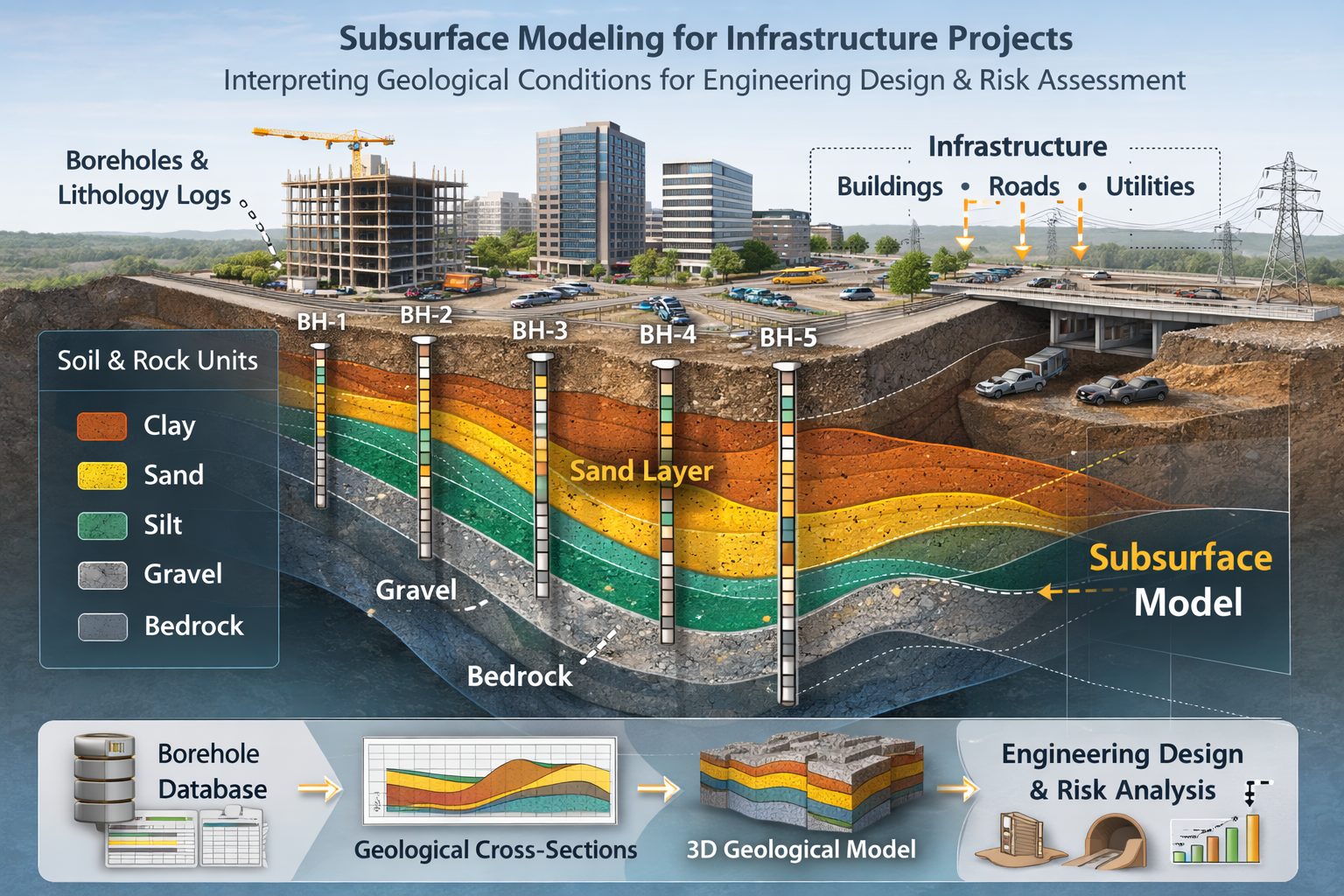
Because most of the subsurface cannot be directly observed, engineers and geologists rely on subsurface models to interpret geological conditions. These models are developed using data collected from boreholes, geological surveys, laboratory tests, and geophysical investigations.
Subsurface modeling involves organizing this information into a structured framework that describes how geological layers extend beneath a project site. The resulting models help engineers visualize soil stratigraphy, evaluate geotechnical risks, analyze groundwater behavior, and plan construction activities.
Advances in digital technology have significantly improved the ability to build and analyze subsurface models. Geological modeling software can now generate cross-sections, fence diagrams, and three-dimensional representations of subsurface geology.
This article explains how subsurface models are developed for engineering projects, the types of data used in these models, and the role they play in infrastructure design and environmental management.
What Is a Subsurface Model?
A subsurface model is a representation of the geological conditions beneath the ground surface. It describes the distribution of soil and rock layers, geological structures, and groundwater systems within a specific area.
Subsurface models can take several forms depending on the complexity of the project.
The simplest models are geological cross-sections that illustrate how layers extend along a single line across a site. More complex models may include fence diagrams that combine multiple cross-sections to represent geology in multiple directions.
Advanced projects may use three-dimensional models that simulate the entire subsurface volume beneath a site.
Regardless of the format, the goal of subsurface modeling is to provide a clear and accurate representation of geological conditions that can support engineering decision-making.
Data Sources Used in Subsurface Modeling
Subsurface models rely on multiple sources of geological and geotechnical data. Each data type provides information about different aspects of the subsurface environment.
Borehole Data
Borehole drilling is one of the most important methods used to collect subsurface information. During drilling operations, geologists record the sequence of soil and rock layers encountered at each borehole location.
Borehole logs typically include:
- lithology descriptions
- depth intervals
- soil classification data
- groundwater observations
- sampling information
These logs provide the primary data used to construct subsurface models.
Laboratory Test Results
Soil and rock samples collected from boreholes are often tested in laboratories to determine their physical and mechanical properties.
Laboratory tests may measure:
- grain size distribution
- moisture content
- shear strength
- compressibility
- permeability
These properties help engineers evaluate how geological materials will behave under load or when exposed to groundwater.
Laboratory results are often integrated into subsurface models to support geotechnical analysis.
Geological Mapping
Surface geological mapping can provide valuable information about regional stratigraphy and geological structures.
Mapping may reveal features such as:
- bedrock outcrops
- sedimentary formations
- faults and folds
These observations can help geologists interpret subsurface conditions beyond the borehole locations.
Geophysical Surveys
Geophysical methods can supplement borehole data by providing information about the subsurface between boreholes.
Common geophysical techniques include:
- seismic surveys
- electrical resistivity surveys
- ground penetrating radar
These methods measure physical properties of subsurface materials and can detect variations in geological structure.
Although geophysical data typically has lower resolution than borehole logs, it can provide valuable insights into large-scale geological features.
Building Subsurface Models
Developing a subsurface model involves several stages, beginning with data collection and ending with geological interpretation.
Data Compilation
The first step is compiling all available geological and geotechnical data. Borehole logs, laboratory results, and geophysical survey data must be organized into structured datasets.
Borehole databases are often used to store this information.
Geological Interpretation
Geologists examine the compiled data to identify patterns in the distribution of geological materials.
They analyze lithology descriptions, stratigraphic relationships, and regional geology to determine how layers extend between boreholes.
Model Construction
Once the geological interpretation has been established, cross-sections or three-dimensional models can be constructed to visualize the subsurface structure.
Digital geological modeling software often assists in this process by generating surfaces that represent geological boundaries.
Model Validation
After the model has been constructed, it must be reviewed and validated.
Geologists check whether the model is consistent with borehole data and known geological processes.
If inconsistencies are identified, the interpretation may be revised.
Engineering Applications of Subsurface Models
Subsurface models support many aspects of engineering design and environmental management.
Foundation Design
Engineers use subsurface models to determine the types of soils beneath a structure and evaluate their load-bearing capacity.
Understanding soil stratigraphy helps engineers choose appropriate foundation systems such as shallow foundations, piles, or caissons.
Slope Stability Analysis
Subsurface models are used to evaluate the stability of slopes and embankments.
Engineers analyze how soil layers and groundwater conditions influence slope stability.
Tunnel and Excavation Design
Large infrastructure projects such as tunnels and underground transportation systems require detailed knowledge of subsurface geology.
Subsurface models help engineers anticipate geological conditions that may affect excavation methods.
Groundwater Management
Hydrogeologists use subsurface models to analyze groundwater flow systems.
Understanding the distribution of permeable and impermeable layers is essential for predicting groundwater movement and managing water resources.
Uncertainty in Subsurface Modeling
Because subsurface models rely on limited data, uncertainty is an inherent part of geological interpretation.
Boreholes provide information only at specific locations, leaving large areas between boreholes that must be interpreted.
Geologists must consider the possibility that geological features such as sand lenses, buried channels, or pinch-outs may exist between boreholes.
Communicating uncertainty is an important aspect of subsurface modeling.
Engineering reports often include discussions of data limitations and recommendations for additional investigations if necessary.
Digital Tools for Subsurface Modeling
Modern geological software has greatly improved the ability to construct and visualize subsurface models.
These tools allow users to import borehole databases and generate digital representations of subsurface geology.
Common visualization tools include:
- geological cross-sections
- fence diagrams
- three-dimensional geological models
Digital models allow engineers and geologists to explore the subsurface from multiple perspectives.
These tools can also support simulations such as groundwater flow modeling or contaminant transport analysis.
Best Practices for Developing Subsurface Models
Developing reliable subsurface models requires careful data management and geological interpretation.
Some recommended practices include:
- ensuring borehole data is accurately recorded and validated
- standardizing lithology descriptions
- integrating multiple data sources
- reviewing models for geological consistency
- updating models as new data becomes available
These practices help improve the accuracy of subsurface interpretations and support better engineering decisions.
The Future of Subsurface Modeling
Advances in computing technology and data integration are driving new developments in subsurface modeling.
Three-dimensional modeling platforms are becoming more accessible and capable of handling large geological datasets.
Cloud-based systems allow teams to collaborate on geological models across different locations.
Emerging technologies such as digital twins may allow subsurface models to be updated continuously as new data becomes available.
These innovations will help engineers and geologists better understand complex geological systems.
Conclusion
Subsurface modeling plays a vital role in engineering projects by providing a structured interpretation of geological conditions beneath a site.
By integrating borehole data, laboratory test results, geological mapping, and geophysical surveys, engineers and geologists can develop models that describe how soil and rock layers extend across a project area.
Although uncertainty is inherent in subsurface interpretation, careful data management and geological expertise can produce reliable models that support engineering design and environmental management.
As digital modeling tools continue to evolve, subsurface models will become even more powerful tools for understanding the hidden structure of the Earth beneath our infrastructure.
Learn more about our Solutions
- GaeaSynergy Platform for Geoscientific Analysis
- WinLoG Borehole and Well Log Data Management
- WinFence Cross-section and Fence Diagram Visualization
Related Articles
- Geological Cross-Sections from Borehole Data: A Complete Engineering Guide
- Geological Modeling Software and Tools: Digital Platforms for Subsurface Interpretation
- Common Mistakes When Creating Geological Cross-Sections from Borehole Data
- How Borehole Spacing Affects Geological Cross-Section Accuracy
- Preparing Borehole Databases for Cross-Section Software
- How Lithological Correlation Works Between Boreholes
- Understanding Fence Diagrams in Geological Modeling
- Common Data Errors in Borehole Databases and How to Fix Them
- Using Geological Cross-Sections in Geotechnical Engineering
- Borehole Coordinate Systems and Mapping for Geological Modeling
- Depth vs Elevation in Borehole Databases for Geological Modeling
- Interpreting Geological Variability Between Boreholes
- Building Geological Cross-Sections from Borehole Data: A Step-by-Step Workflow
- How Geological Software Interpolates Subsurface Layers Between Boreholes
- Borehole Data Visualization Techniques for Geological Modeling
- Managing Large Borehole Data Sets in Engineering Projects
- Understanding Pinch-Outs and Missing Geological Layers in Subsurface Interpretation
- Digital Workflows for Geotechnical Data: Managing Borehole Information from Field to Model
- Best Practices for Borehole Logging and Interpretation in Geological and Geotechnical Investigations