
Utility clearance is one of the most critical pre-field steps in a Phase II Environmental Site Assessment (ESA). Before any drilling, test pitting, or intrusive sampling begins, it is essential to identify and verify the location of all underground utilities to prevent damage, protect personnel, and ensure regulatory compliance.
Phase II ESA investigations often involve subsurface activities such as borehole drilling and monitoring well installation. These activities can intersect with buried infrastructure like gas pipelines, electrical conduits, water mains, telecommunications lines, and sewer systems. Striking any of these can result in serious injury, environmental harm, service disruption, and significant legal liability.
In Canada, services such as Ontario One Call play a central role in the clearance process, while in the United States, the system is accessed through 811. However, relying solely on public utility locates is not sufficient—comprehensive clearance requires multiple steps and verification procedures.
This article provides a detailed, WordPress-ready guide to the utility clearance process for a Phase II ESA, including procedures, responsibilities, technologies, risks, and best practices.
Why Utility Clearance Is Essential
Utility clearance is not optional—it is a mandatory safety and compliance requirement.
Key Objectives:
- Prevent damage to underground infrastructure
- Protect field personnel and the public
- Avoid costly repairs and service disruptions
- Ensure regulatory compliance
- Reduce project delays and liability
Failure to properly clear utilities can result in:
- Gas leaks or explosions
- Electrical hazards
- Flooding from damaged water mains
- Communication outages
- Legal and financial penalties
Overview of the Utility Clearance Process
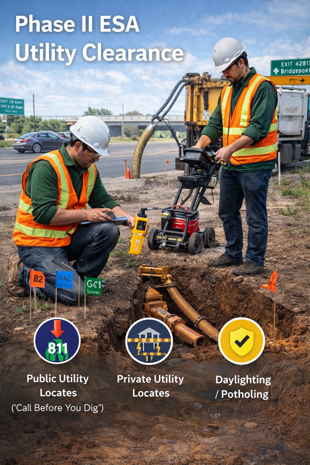
The utility clearance process is a multi-step system involving:
- Public utility locates
- Private utility locates
- Review and verification (daylighting)
Each step builds upon the previous one to ensure complete coverage of all underground infrastructure.
Public Utility Locates (“Call Before You Dig”)
The first and most fundamental step is to notify public utility locating services.
What Is “Call Before You Dig”?
“Call Before You Dig” programs act as a central notification system that alerts utility owners of planned excavation work.
In Canada:
- Ontario One Call
- BC 1 Call and similar provincial services
In the United States:
- 811
How It Works
- The environmental consultant submits a locate request
- Utility owners are notified
- Each utility marks their infrastructure on-site
Marking Methods:
- Spray paint
- Flags
- Stakes
Standard Color Codes:
- Red: Electric
- Yellow: Gas
- Blue: Water
- Green: Sewer
- Orange: Communications
Turnaround Time
- Typically 2–5 business days
- May vary depending on jurisdiction and site complexity
Limitations of Public Locates
Public locates only identify:
- Utilities owned by registered companies
- Major infrastructure networks
They do not include private utilities, which can be extensive on industrial or commercial sites.
Private Utility Locates (Site-Specific Surveys)
To achieve full clearance, private utility locating is required.
Why Private Locates Are Necessary
Private utilities include:
- Electrical lines between buildings
- Lighting systems
- Security wiring
- Septic systems
- Stormwater infrastructure
These are not covered by public services and pose significant risks if unidentified.
Technologies Used
Ground Penetrating Radar (GPR)
- Uses radar pulses to detect subsurface objects
- Effective for non-metallic utilities (e.g., PVC pipes)
Electromagnetic (EM) Locating
- Detects conductive materials (metal pipes, cables)
- Commonly used alongside GPR
Benefits of Private Locates
- Identifies hidden infrastructure
- Reduces risk of utility strikes
- Provides higher confidence in clearance
Review and Verification (Daylighting / Potholing)
Even with public and private locates, verification is essential.
What Is Daylighting?
Daylighting (or potholing) involves physically exposing underground utilities to confirm their location.
Methods:
- Hand digging
- Vacuum excavation (hydrovac)
When Is Daylighting Required?
- Near critical infrastructure
- At high-risk intersections
- Before mechanical drilling
- When locate data is unclear or conflicting
Typical Depth Verification
- Usually 1.5 to 2.0 meters
- Ensures safe clearance for drilling
Importance of Verification
Daylighting provides:
- Visual confirmation
- Reduced uncertainty
- Enhanced safety
Roles and Responsibilities
Environmental Consultant / Qualified Person (QP)
Responsible for:
- Initiating locate requests
- Coordinating private locates
- Reviewing all data
- Approving safe drilling locations
Property Owner
Responsible for:
- Providing access
- Supplying utility drawings or as-builts
- Disclosing known infrastructure
Utility Locators
Responsible for:
- Accurately marking utilities
- Providing documentation
- Communicating limitations
Documentation Requirements
Utility clearance must be fully documented in the Phase II ESA report.
Required Documentation:
- Confirmation of public locate requests
- Records of private utility surveys
- Site maps showing utility markings
- Notes on daylighting activities
- Clearance approvals for drilling
This documentation demonstrates due diligence and regulatory compliance.
Common Challenges in Utility Clearance
1. Incomplete Utility Records
Older sites may lack accurate drawings.
Solution: Combine GPR, EM, and field verification.
2. Congested Urban Environments
High density of utilities increases complexity.
Solution: Increase spacing of sampling points and use daylighting.
3. Weather Conditions
Rain, snow, or frozen ground can obscure markings.
Solution: Schedule locates strategically and verify markings before work.
4. Conflicting Data
Different sources may provide inconsistent information.
Solution: Prioritize physical verification.
Best Practices for Utility Clearance
- Always request public locates early
- Never rely solely on public locates
- Use qualified private locating professionals
- Conduct daylighting for high-risk areas
- Maintain clear communication among all parties
- Document everything thoroughly
Safety Considerations
Utility clearance is directly tied to site safety.
Key Risks:
- Gas line rupture
- Electrical shock
- Flooding
- Structural damage
Mitigation Measures:
- Maintain safe distances from marked utilities
- Use non-invasive methods near utilities
- Follow HASP protocols
- Stop work if unexpected utilities are encountered
Integration with Phase II ESA Workflow
Utility clearance is closely linked to:
- Sampling plan development
- Health and Safety Plan (HASP)
- Field scheduling
- Regulatory compliance
No intrusive work should begin without confirmed clearance.
Legal and Regulatory Implications
Failure to follow utility clearance procedures can result in:
- Regulatory fines
- Legal liability
- Project shutdowns
- Insurance claims
Compliance with services like Ontario One Call is often legally required.
Advances in Utility Detection Technology
Emerging technologies are improving accuracy and efficiency:
- 3D subsurface mapping
- GPS-integrated locating systems
- Digital utility mapping platforms
These innovations enhance safety and reduce uncertainty.
Conclusion
The utility clearance process is a non-negotiable step in Phase II ESA investigations. It protects workers, infrastructure, and the environment while ensuring compliance with regulatory requirements.
By following a structured approach—public locates, private surveys, and physical verification—environmental professionals can confidently proceed with subsurface investigations.
Ultimately, effective utility clearance is not just about avoiding risks—it is about enabling safe, efficient, and successful environmental site assessments.
👉 Learn more about our Automated Environmental Site Assessment Solution
Related Articles
- Methodology for Conducting a Phase II Environmental Site Assessment (ESA)
- Key Uses of a Phase II Environmental Site Assessment (ESA) Report
- Market Drivers and Trends for Phase II Environmental Site Assessments
- Role of Reviewing Existing Data for a Phase II Environmental Site Assessment
- Methodology for Identifying Contaminants of Concern (COCs) for a Phase II Environmental Site Assessment
- Key Components of a Phase II ESA Sampling Plan
- Key Components of a Phase II ESA Health and Safety Plan (HASP)
- Key Considerations for Permit Acquisition for a Phase II ESA
- Drilling and Sampling for a Phase II ESA: Methods, Equipment, and Best Practices
- Installation of Monitoring Wells for a Phase II Environmental Site Assessment (ESA)
- Phase II ESA Quality Control Procedures: Ensuring Accurate, Defensible Environmental Data
- Sample Handling Procedures for a Phase II ESA: Ensuring Data Integrity from Field to Laboratory
- Laboratory Analysis and Data Interpretation for a Phase II ESA
- Reporting and Recommendations for a Phase II Environmental Site Assessment (ESA)
- Differences Between a Phase II ESA in Canada and the United States