
A Phase I Environmental Site Assessment (ESA) is designed to identify potential environmental contamination liabilities through a structured, non-intrusive investigation. While much attention is often given to historical records and hazardous material storage, one of the most critical—and sometimes overlooked—components is the documentation of drainage patterns and surface water.
Surface hydrology plays a central role in how contaminants move across and beyond a site. Water is one of the primary transport mechanisms for pollutants, meaning that understanding drainage pathways is essential for identifying migration routes, exposure risks, and potential receptors.
In addition, documenting the general condition of buildings and structures provides valuable insight into how hazardous substances may have been stored, handled, or released.
This article provides a comprehensive guide to documenting:
- Drainage patterns and surface water
- Site hydrology and contaminant migration pathways
- Building and structural conditions
- Integration of findings into a Phase I ESA report
Why Drainage and Surface Water Matter in a Phase I ESA
Water moves contamination.
Whether from rainfall, snowmelt, or process water, surface flow can transport contaminants from one area to another—sometimes far beyond the original source. This makes drainage patterns a critical component in identifying:
- Potential contaminant migration pathways
- Off-site impacts to adjacent properties
- Risks to surface water bodies and ecosystems
- Pathways to groundwater recharge zones
In many cases, stormwater infrastructure and natural watercourses act as conduits, spreading contamination through storm sewers, ditches, and streams.
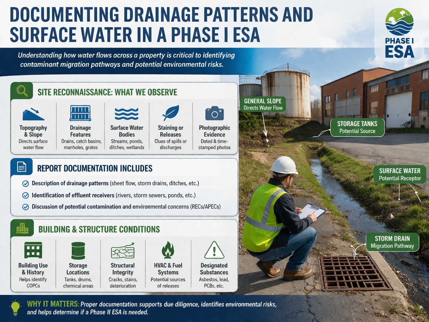
Observation During Site Reconnaissance: Drainage and Surface Water
Site reconnaissance is where environmental professionals directly observe how water interacts with the site. This step provides real-time insight into drainage behavior and potential environmental concerns.
General Topography and Slope
Understanding the topography of the site is fundamental to assessing drainage.
Environmental professionals evaluate:
- Elevation changes across the site
- Natural slopes and grading
- Direction of surface water flow
- Low-lying areas where water may accumulate
For example:
- A sloped industrial yard may direct runoff toward a neighboring property
- Depressions may act as collection points for contaminated water
- Improper grading can cause water to flow toward sensitive receptors
Even subtle changes in elevation can significantly influence contaminant transport.
Drainage Features
Man-made drainage infrastructure must be carefully documented, including:
- Storm drains and catch basins
- Manholes and storm sewer grates
- Culverts and drainage ditches
- Sumps and oil-water separators
These features often represent direct pathways for contaminants to enter municipal stormwater systems or natural water bodies.
Environmental professionals assess:
- Locations and distribution of drainage features
- Connectivity between drainage systems
- Signs of blockage, damage, or overflow
- Evidence of staining or discharge near drains
For instance, staining around a catch basin may indicate repeated discharge of contaminated runoff.
Surface Water Bodies
The presence of surface water is a key environmental consideration. During site reconnaissance, professionals document:
- Streams, rivers, and creeks
- Ponds and lakes
- Wetlands and drainage swales
- Stormwater retention or detention ponds
Important observations include:
- Proximity to the site
- Flow direction
- Seasonal vs. permanent water presence
- Physical condition (e.g., turbidity, sheen, debris)
Even man-made ponds used for stormwater management must be evaluated, as they can accumulate contaminants over time.
Evidence of Staining or Releases
Visual indicators near drainage pathways can reveal potential contamination, such as:
- Discolored soil or pavement
- Oily sheens on standing water
- Stressed or dead vegetation
- Sediment accumulation in drainage areas
These signs are especially important when located:
- Near storm drains
- Along drainage ditches
- Adjacent to water bodies
Such observations may indicate unauthorized discharge, leaks, or historical spills.
Photographic Evidence
Photographs are essential for documenting site conditions and supporting findings.
Best practices include:
- Capturing wide-angle and close-up images
- Including key drainage features and water bodies
- Documenting staining or environmental concerns
- Ensuring images are dated and time-stamped
Photographs serve as:
- Visual evidence for the report
- A record for future comparison
- Supporting documentation for RECs or APECs
Documentation in the Phase I ESA Report: Drainage and Surface Water
Once observations are collected, they must be clearly documented in the Phase I ESA report.
Describing Drainage Patterns
The report should describe how water moves across the site, including:
- Sheet flow across surfaces
- Concentrated flow toward drainage features
- Flow into stormwater systems
- Discharge to natural water bodies
For example:
“Surface runoff from the western portion of the site flows via sheet flow toward a series of catch basins that discharge into the municipal storm sewer system.”
Identifying Effluent Receivers
An essential part of documentation is identifying where water ultimately goes.
Common effluent receivers include:
- Storm sewer systems
- Drainage ditches
- Streams or rivers
- Retention ponds
Understanding the endpoint of drainage helps assess:
- Potential environmental impact
- Regulatory implications
- Risk to downstream receptors
Evaluating Environmental Concerns
Any evidence of contamination related to drainage or surface water must be discussed.
This includes:
- Proximity to historical industrial activities
- Evidence of staining or discharge
- Potential pathways for contaminant migration
Such findings may be classified as:
- Recognized Environmental Conditions (RECs)
- Areas of Potential Environmental Concern (APECs)
Documenting the General Condition of Buildings and Structures
In addition to surface hydrology, the condition of buildings and structures provides critical clues about environmental risk.
Building Type and Use
Understanding the current and historical use of structures is essential.
Examples include:
- Dry cleaning facilities (solvents)
- Automotive repair shops (oil and fuels)
- Industrial manufacturing (chemicals)
- Residential buildings (lower risk profile)
Different uses are associated with different contaminants of potential concern (COPCs).
Storage Locations
Environmental professionals identify areas where hazardous materials may be stored or handled, including:
- Chemical storage rooms
- Fuel storage areas
- Aboveground storage tanks (ASTs)
- Evidence of underground storage tanks (USTs)
Key observations include:
- Presence of containers or tanks
- Signs of leakage or corrosion
- Secondary containment systems
These areas are often primary sources of contamination.
Structural Integrity
The condition of structures can indicate potential environmental issues.
Professionals look for:
- Cracks in concrete floors
- Damaged or deteriorated surfaces
- Evidence of spills or staining
- Poor maintenance or neglect
For example:
- Cracked flooring may allow chemicals to migrate into subsurface soils
- Dilapidated areas may indicate improper waste handling
Heating and Cooling Systems
HVAC systems and associated equipment can also be sources of contamination.
Documentation includes:
- Type of heating system (e.g., oil-fired, gas)
- Presence of fuel storage tanks
- Condition of boilers and piping
- Evidence of leaks or spills
Fuel oil systems, in particular, are common sources of petroleum contamination.
Designated Substances
Although sampling is not part of a Phase I ESA, the potential presence of designated substances must be noted, especially in older buildings.
These may include:
- Asbestos-containing materials (ACMs)
- Lead-based paint
- Polychlorinated biphenyls (PCBs)
- Mercury-containing equipment
These substances are especially relevant for:
- Building renovations
- Demolition projects
- Occupational health considerations
Documentation in the Report: Buildings and Structures
Describing Structures
The report should include:
- Number of buildings
- Building sizes and construction types
- Foundation types (e.g., slab-on-grade, basement)
- Current and historical uses
This provides context for evaluating environmental risk.
Access Limitations
Any areas not accessed during the assessment must be documented, including:
- Locked rooms or restricted areas
- Unsafe or structurally unsound locations
- Weather-related limitations
Transparency about access limitations is critical for report defensibility.
Identifying Potential Contaminating Activities (PCAs)
The report must identify and evaluate PCAs associated with structures, such as:
- Chemical storage and handling
- Fuel storage systems
- Waste management practices
These activities are assessed for their potential to result in:
- Releases of hazardous substances
- Environmental contamination
- RECs or APECs
Integrating Drainage and Structural Observations
The true value of a Phase I ESA lies in integrating multiple lines of evidence.
For example:
- A leaking storage tank combined with drainage toward a nearby creek increases risk
- Staining near a storm drain connected to a river suggests potential off-site impact
- Poor building conditions combined with improper disposal practices indicate higher contamination potential
By connecting these observations, environmental professionals can develop a comprehensive understanding of environmental risk.
Limitations of the Assessment
While thorough, the Phase I ESA has limitations:
- No subsurface investigation
- Reliance on visible and accessible information
- Potential for undocumented conditions
These limitations highlight the importance of professional judgment and, when necessary, further investigation.
Conclusion
Documenting drainage patterns, surface water, and building conditions is essential for understanding how contaminants may move through and beyond a site. These elements provide critical insight into environmental pathways, potential receptors, and sources of contamination.
By carefully observing and documenting:
- Surface hydrology
- Drainage infrastructure
- Water bodies
- Structural conditions
Environmental Professionals can identify potential environmental concerns and determine whether further investigation is warranted.
Ultimately, this comprehensive documentation ensures that Phase I ESAs meet due diligence requirements, support informed decision-making, and provide a solid foundation for future environmental assessments or remediation efforts.
👉 Learn more about our Automated Environmental Site Assessment Solution
Related Articles
- Overview of a Phase I Environmental Site Assessment (ESA): A Complete Guide for Due Diligence
- Key Uses of a Phase I Environmental Site Assessment
- Market for Phase I Environmental Site Assessments
- The Role of Historical Source Review in Phase I Environmental Site Assessments
- The Role of Environmental Database Reviews in Phase I Environmental Site Assessments
- The Review of Property Records in a Phase I Environmental Site Assessment
- The Role of Visual Inspections in a Phase I Environmental Site Assessment
- Identifying Hazardous Substances and Petroleum Products in a Phase I Environmental Site Assessment
- The Role of Photographs in Phase I Environmental Site Assessments
- The Use of Drones in a Phase I Environmental Site Assessment
- Conducting Interviews with Property Owners and Occupants for a Phase I ESA
- Conducting Interviews with Government Officials for a Phase I ESA
- Conducting Interviews with Neighbors for a Phase I ESA
- Key Components of a Phase I ESA Conclusion
- Key Distinctions Between ASTM E1527-21 and CSA Z768-01