
With the rise of technology and data analysis, geoscientific analysis software is paving the way for new discoveries in fields such as environmental science, geology, and resource management. This blog post dives deep into the uses of geoscientific analysis, highlighting its importance and relevancy in our modern world. We will explore how these analytical tools are being utilized across various industries, the benefits they provide, and how you can leverage them for better decision-making. Get ready to unlock the potential of geoscientific analysis!
Introduction to Geoscientific Analysis
Geoscientific analysis refers to a range of techniques and methodologies used to study the Earth’s processes, features, and materials. Its applications span across numerous fields including geology, environmental science, and natural resource management. The advent of geoscientific analysis software has revolutionized these fields, making complex data more accessible and actionable.
1. Understanding the Basics of Geoscientific Analysis
Geoscientific analysis encompasses several methodologies such as remote sensing, GIS (Geographic Information Systems), and geostatistics. These techniques work collaboratively to collect data on various geological formations, soil types, mineral resources, and environmental conditions.
2. Applications in Environmental Science
In environmental science, geoscientific analysis plays a vital role. It allows scientists to monitor and assess environmental changes due to natural phenomena and human actions. For instance, remote sensing can track deforestation, natural disasters, and climate change impacts while GIS aids in mapping sensitive ecosystems for conservation purposes. This data helps policymakers make informed decisions regarding environmental protection.
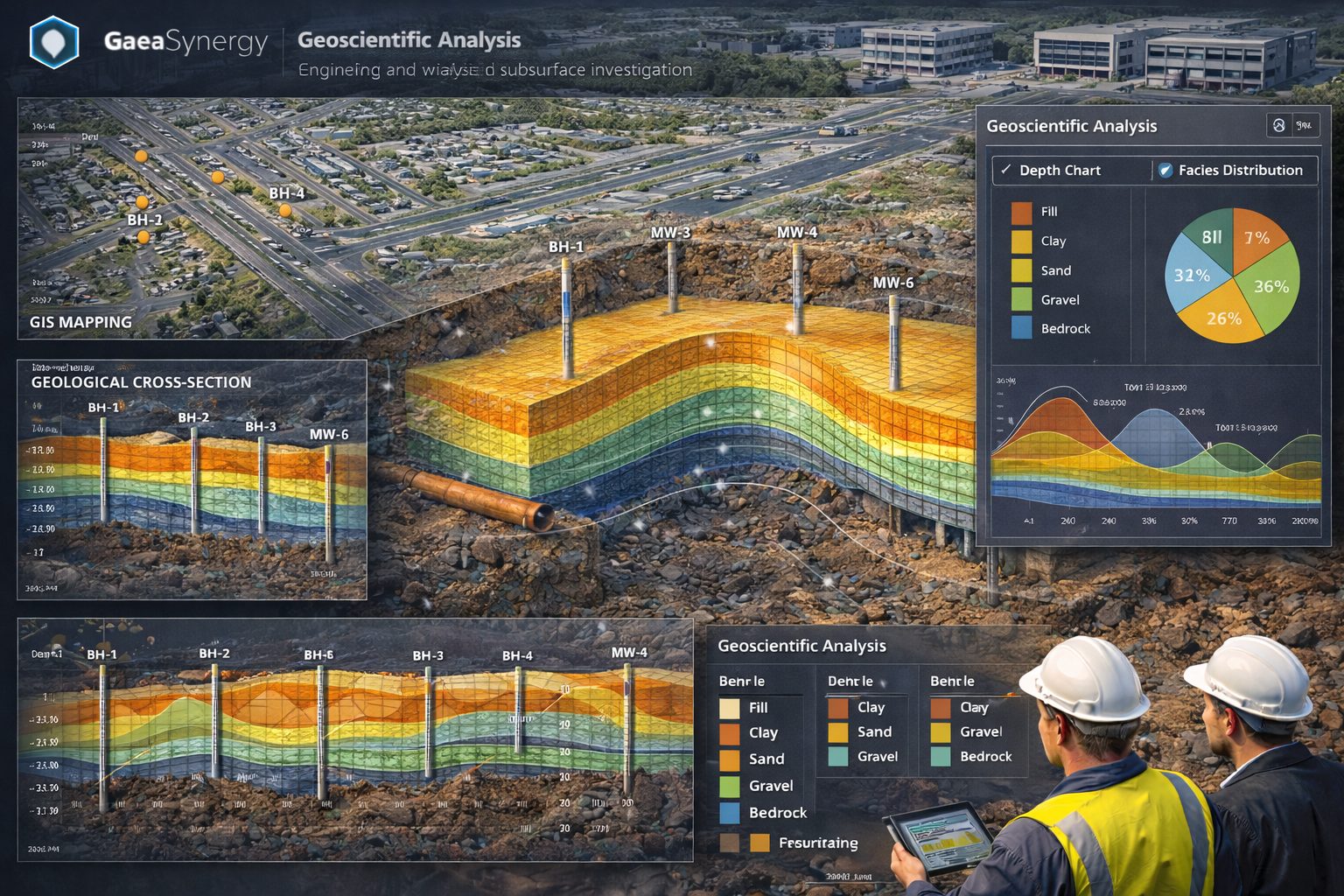
3. Geoscientific Analysis in Civil Engineering
Geoscientific analysis is essential in civil engineering and construction. It provides vital information for site selection and development by analyzing soil stability, subsurface conditions, and potential hazards. Engineers utilize geoscientific data to ensure structures are built on safe foundations and are resilient to environmental risks like earthquakes and landslides.
4. Resource Management and Exploration
One of the major applications of geoscientific analysis is in the exploration and management of natural resources such as water, minerals, and energy. In mining, geoscientists analyze geological data to determine the best locations for exploration and extraction while minimizing environmental impacts. In the water sector, geospatial data helps in locating aquifers and understanding water flows, which is essential for sustainable water management.
5. Geoscientific Analysis in Agriculture
Agriculture also benefits from geoscientific analysis. By understanding soil composition and health through analysis, farmers can adopt more sustainable practices, optimize crop yields, and reduce the adverse effects of pesticides and fertilizers. Techniques such as precision farming use geolocation data to target specific areas of a farm for treatment or irrigation, leading to increased efficiency and productivity.
6. Climate Change Research
Geoscientific analysis plays a crucial role in climate change research. Scientists utilize geological and atmospheric data to study historical climate patterns and project future trends. Understanding these patterns helps communities prepare for climate-related challenges such as rising sea levels, extreme weather, and changes in biodiversity.
7. Disaster Management and Mitigation
In disaster management, geoscientific analysis is vital. It provides data for risk assessment and disaster preparedness strategies. For example, analyzing fault lines and seismic activity helps in earthquake preparedness while studying volcanic activity can aid in evacuations and protect communities from hazards.
8. Data Visualization in Geoscientific Analysis
One of the most significant advancements in geoscientific analysis is the ability to visualize complex data through maps and 3D models. Visualization tools integrated into geoscientific software make it easy for users to interpret large datasets effectively. This capability enhances collaboration between geoscientists, engineers, and decision-makers, making discussions and planning more efficient.
9. Integrating Technology for Enhanced Analysis
With ongoing technological advancements, the future of geoscientific analysis looks promising. Emerging technologies include machine learning and artificial intelligence, which allow for more sophisticated data processing and predictive modeling. These innovations will enable faster, more accurate analysis and enhance our ability to address the complex challenges facing our environment and resources.
10. Training and Education in Geoscientific Analysis
For those looking to get involved in geoscientific analysis, pursuing education in geology, environmental science, or data analysis is essential. Several universities offer specialized programs focusing on these fields. Software training is also critical, allowing users to harness the comprehensive functionalities of geoscientific analysis tools effectively.
Conclusion – Where Do We Go From Here?
The uses of geoscientific analysis are vast and impactful across various sectors. Understanding its applications not only enhances our ability to manage resources sustainably but also supports societal and environmental well-being. By leveraging geoscientific analysis, we can make more informed decisions, mitigate risks, and pave the way for a sustainable future.
So now what? We encourage you to explore the world of geoscientific analysis further. Share this blog with a friend or colleague who may benefit from understanding these powerful tools and their applications. Together, let’s propel the conversation and knowledge surrounding geoscience into broader circles!
Learn more about our Solutions
- GaeaSynergy Platform for Geoscientific Analysis
- Borehole and Well Log Data Management
- Cross Sections and Sub-surface Visualization
- Geotechnical Data Management System
- Environmental Data Management System
Related Articles
- GaeaSynergy: Integrated Geological, Geotechnical, and Environmental Data Management Platform
- The Complete Guide to Borehole Data Solutions
- The Complete Guide to Geotechnical Data Management
- The Complete Guide to Environmental Data Management
- Geological Cross-Sections from Borehole Data: A Complete Engineering Guide
- Integrated Geological and Geotechnical Data Platforms
- Why Engineering Firms Need Integrated Subsurface Data Platforms
- Managing Geological, Geotechnical, and Environmental Data in One Platform
- Digital Platforms for Subsurface Investigation Data
- Connecting Borehole Databases with Geological Modeling Software
- GIS Integration in Geological and Geotechnical Data Platforms
- Data Governance in Geological and Engineering Platforms
- The Future of Integrated Subsurface Data Platforms
- How Artificial Intelligence Is Transforming Geotechnical & Environmental Engineering
- Beyond 2D: Integrating Boring Logs with 3D Models for Complex Infrastructure Projects
- Protecting Our Water: Monitoring Contaminant Plumes Through Real-Time Stratigraphic Mapping
- Strategic Data Management in GaeaSynergy
- Seamless Data Flow: Mastering Import and Export in GaeaSynergy
- Mapping the Site: GIS and Spatial Data Management in GaeaSynergy
- Comprehensive Site Intelligence: Integrating Subsurface Data and Infrastructure in GaeaSynergy 3D
- Visualizing the Invisible: 3D Above and Below Ground Structures in GaeaSynergy
- Mastering Subsurface Visualization: Contouring and Gridding in GaeaSynergy
- From Data to Discovery: Visualizing the Subsurface with GaeaSynergy
- GAEA Technologies Software in the Oil & Gas Industry
- Beyond the Surface: How GAEA Technologies Software Powers Modern Mining
- Winning More Bids: Using High-Resolution Subsurface Visualization to Demonstrate Project Certainty
- Selecting the Right Gridding Algorithm for Your Contour Map
- The Science of Doubt: How to Quantify and Visualize Subsurface Uncertainty in Geological Models