
Engineering and environmental projects rely heavily on accurate subsurface information. Geological formations, soil properties, groundwater conditions, and environmental monitoring data all play a critical role in understanding site conditions and making informed decisions. However, many organizations still manage these datasets in separate systems—spreadsheets for borehole logs, specialized software for geological modeling, GIS tools for mapping, and independent databases for environmental monitoring.
This fragmented approach creates challenges in data consistency, accessibility, and collaboration. Engineers, geologists, and environmental specialists may struggle to maintain a unified understanding of subsurface conditions when data is scattered across multiple systems.
Managing geological, geotechnical, and environmental data in one integrated platform solves these problems by centralizing information within a unified environment. Integrated data platforms allow organizations to store, validate, analyze, and visualize subsurface data more efficiently, improving project workflows and decision-making.
This article explores how integrated platforms work, the types of data they manage, and why combining geological, geotechnical, and environmental datasets within a single system is becoming essential for modern engineering and environmental projects.
The Growing Volume of Subsurface Data
Subsurface investigations generate a wide range of data types throughout the lifecycle of a project. These datasets often originate from different teams and disciplines, each contributing specialized information.
Common data sources include:
- Borehole drilling logs
- Cone penetration testing (CPT) results
- Laboratory soil and rock testing
- Geological mapping and interpretations
- Groundwater monitoring data
- Environmental sampling results
- Geophysical surveys
- GIS spatial data
Each dataset provides important insight into subsurface conditions. However, managing them separately can make it difficult to see the full picture.
For example, environmental sampling results may depend on geological formations and groundwater flow patterns. If environmental data is stored separately from geological data, understanding contaminant migration becomes more complicated.
Integrated platforms allow all of these datasets to be managed together, enabling more comprehensive analysis.
Challenges of Managing Data in Separate Systems
Many engineering firms historically adopted different software tools for specific tasks. While each tool may perform its function well, the lack of integration creates several challenges.
Data Fragmentation
When geological, geotechnical, and environmental data are stored in separate systems, it becomes difficult to maintain a single source of truth.
Borehole data may exist in one database, while laboratory results are stored elsewhere and monitoring data is managed in another system. This fragmentation makes it challenging to ensure that all teams are working with the same information.
Data Inconsistencies
Transferring data between systems often requires manual exports and imports. This process increases the risk of errors such as:
- incorrect coordinates
- mismatched depth intervals
- inconsistent lithology codes
- duplicated records
Even small inconsistencies can lead to incorrect interpretations of subsurface conditions.
Limited Collaboration
Large projects involve multiple specialists, including:
- geologists
- geotechnical engineers
- environmental scientists
- GIS analysts
- project managers
If each group uses separate tools and datasets, collaboration becomes more difficult. Team members may not have access to the latest data, leading to conflicting interpretations.
Inefficient Workflows
Engineers and geologists often spend significant time preparing data before analysis can begin. Tasks such as cleaning spreadsheets, converting coordinate systems, and merging datasets can consume valuable project time.
Integrated platforms streamline these workflows by organizing data within a structured system designed specifically for subsurface information.
What Is an Integrated Subsurface Data Platform?
An integrated subsurface data platform is a software environment that centralizes geological, geotechnical, and environmental data within a single database system.
These platforms combine several capabilities into one solution, including:
- borehole database management
- geological modeling tools
- GIS mapping and spatial analysis
- environmental monitoring data management
- cross-section generation
- 3D subsurface visualization
Rather than working with multiple disconnected applications, users interact with one system that supports the full lifecycle of subsurface data.
This approach ensures that all datasets are linked through common references such as location coordinates, borehole identifiers, and depth intervals.
Geological Data Management
Geological data forms the foundation for understanding subsurface conditions. Integrated platforms allow geologists to store and manage detailed geological information within structured databases.
Typical geological data includes:
- lithological descriptions
- stratigraphic units
- geological contacts
- structural features such as faults and fractures
- geological interpretations
Standardized coding systems help ensure that lithology descriptions remain consistent across projects.
By storing geological data within a central platform, organizations can build long-term databases that support future projects and regional studies.
Geotechnical Data Integration
Geotechnical investigations focus on the engineering properties of soil and rock. These properties determine how subsurface materials will behave under loading conditions.
Integrated platforms link geotechnical data directly to the geological context from which samples were collected.
Examples of geotechnical data include:
- Standard Penetration Test (SPT) values
- cone penetration test results
- laboratory strength tests
- consolidation tests
- grain size analyses
- Atterberg limits
When geotechnical data is connected to geological units, engineers can better understand how soil properties vary across different formations.
This integration supports more accurate foundation design and slope stability analysis.
Environmental Data Management
Environmental investigations generate additional datasets related to soil and groundwater quality.
Integrated platforms allow environmental data to be stored alongside geological and geotechnical information.
Examples of environmental data include:
- groundwater monitoring well measurements
- soil and groundwater contaminant concentrations
- sampling event records
- environmental laboratory results
- remediation monitoring data
Environmental datasets often involve time-series measurements. For example, groundwater levels may be recorded monthly or continuously using sensors.
Integrated platforms allow these time-series datasets to be linked to spatial locations and geological units, providing valuable context for environmental analysis.
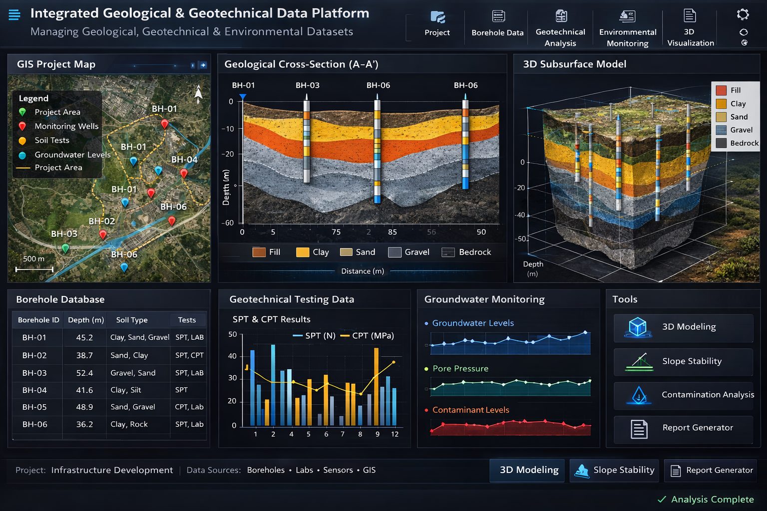
Borehole Data as the Central Framework
Most subsurface investigations rely on boreholes as the primary source of information.
Integrated platforms typically use boreholes as the central framework for organizing subsurface data.
Each borehole record may include:
- geographic coordinates
- ground surface elevation
- drilling method
- lithological intervals
- sampling locations
- field test results
- laboratory data
Because multiple datasets reference the same borehole identifier, the platform can automatically link related information.
For example, a soil sample collected at a specific depth can be associated with both its lithological description and its laboratory test results.
GIS Mapping and Spatial Analysis
Geological and environmental data are inherently spatial. Integrated platforms incorporate GIS capabilities to display and analyze data within a geographic context.
GIS tools allow users to:
- map borehole locations
- overlay geological maps
- display infrastructure and site boundaries
- integrate aerial imagery and topography
Spatial analysis helps identify patterns in subsurface conditions. For example, engineers may analyze how groundwater levels vary across a site or how soil types change with elevation.
GIS integration also supports regional studies by allowing organizations to combine project data with broader geological datasets.
Geological Cross-Sections
Cross-sections provide a valuable way to visualize subsurface conditions along a specific alignment or profile.
Integrated platforms can automatically generate cross-sections using borehole data stored in the database.
Typical cross-section features include:
- borehole projections along a section line
- lithological intervals
- sampling depths
- groundwater levels
- interpreted geological contacts
Because cross-sections are generated directly from the database, they remain consistent with the underlying data.
If new boreholes are added or existing data is updated, the cross-section can be regenerated instantly.
3D Subsurface Visualization
Three-dimensional visualization is becoming increasingly important for complex engineering and environmental projects.
Integrated platforms often include tools for creating 3D models of subsurface conditions.
These models may include:
- borehole traces
- geological surfaces
- stratigraphic volumes
- groundwater surfaces
3D visualization helps users understand the spatial relationships between geological layers and engineering features.
For example, engineers can visualize how bedrock depth varies across a site or how contamination may migrate through different geological units.
Benefits of Managing Data in One Platform
Combining geological, geotechnical, and environmental data within a single platform offers several advantages.
Improved Data Quality
Integrated systems enforce validation rules that reduce common data errors. Standardized coding systems ensure consistency across projects and teams.
High-quality data leads to more reliable interpretations and engineering decisions.
Increased Efficiency
Engineers and geologists spend less time transferring and cleaning data when all information is stored in one system.
Automated workflows allow users to generate cross-sections, maps, and reports quickly.
Better Collaboration
Centralized data platforms allow multiple teams to access the same dataset.
Geologists, engineers, and environmental scientists can work together more effectively when they share a common information environment.
Long-Term Data Preservation
Subsurface investigations represent a significant investment. Integrated platforms allow organizations to maintain long-term databases that preserve valuable geological and environmental information.
Historical data can support future infrastructure projects, environmental assessments, and regional geological studies.
Improved Decision-Making
When all relevant data is available in one system, engineers can make more informed decisions.
For example, foundation designs can consider both soil properties and groundwater conditions, while environmental remediation plans can account for geological structures that influence contaminant migration.
Applications Across Industries
Integrated subsurface data platforms are used across many industries, including:
Infrastructure Engineering
Transportation corridors, bridges, tunnels, and buildings all require detailed understanding of subsurface conditions.
Integrated platforms help engineers manage large volumes of borehole and laboratory data during the design process.
Environmental Consulting
Environmental consultants rely on monitoring data and geological information to assess contaminated sites and design remediation strategies.
Integrated platforms provide the tools needed to manage sampling data and track environmental conditions over time.
Mining and Resource Development
Mining projects require detailed geological models based on drilling programs and geophysical surveys.
Centralized data platforms allow geologists to manage exploration data and build resource models.
Water Resource Management
Hydrogeologists study groundwater systems using borehole data, monitoring wells, and geological maps.
Integrated platforms help manage these datasets and support groundwater modeling.
Future Trends in Integrated Data Platforms
As technology continues to evolve, integrated subsurface data platforms are becoming even more powerful.
Cloud-Based Systems
Cloud technology allows organizations to store and access subsurface data from anywhere. Cloud platforms improve collaboration and allow distributed teams to work on the same datasets.
Automated Data Integration
Modern drilling equipment, laboratory systems, and monitoring sensors increasingly support digital data transfer.
Automated data integration reduces manual entry and improves data accuracy.
Advanced Analytics and Modeling
Machine learning and advanced data analytics may help identify patterns in large geological datasets, improving predictions of subsurface conditions.
These technologies could assist with tasks such as geological interpretation and risk assessment.
Conclusion
Managing geological, geotechnical, and environmental data in one platform provides a powerful solution to the challenges of subsurface data management. By centralizing information within a unified system, organizations can improve data quality, streamline workflows, and enhance collaboration between teams.
Integrated platforms allow engineers and scientists to analyze complex datasets more effectively, combining geological interpretations, engineering properties, and environmental monitoring information within a single environment.
As engineering and environmental projects continue to grow in complexity, the ability to manage subsurface data efficiently will become increasingly important. Organizations that adopt integrated data platforms gain a significant advantage in understanding subsurface conditions and making informed decisions that support safe infrastructure development and environmental protection.
Learn more about our Solutions
- GaeaSynergy Platform for Geoscientific Analysis
- Borehole and Well Log Data Management
- Cross Sections and Sub-surface Visualization
- Geotechnical Data Management System
- Environmental Data Management System
Related Articles
- GaeaSynergy: Integrated Geological, Geotechnical, and Environmental Data Management Platform
- The Complete Guide to Borehole Data Solutions
- The Complete Guide to Geotechnical Data Management
- The Complete Guide to Environmental Data Management
- Geological Cross-Sections from Borehole Data: A Complete Engineering Guide
- Integrated Geological and Geotechnical Data Platforms
- Why Engineering Firms Need Integrated Subsurface Data Platforms
- Digital Platforms for Subsurface Investigation Data
- Connecting Borehole Databases with Geological Modeling Software
- GIS Integration in Geological and Geotechnical Data Platforms
- Data Governance in Geological and Engineering Platforms
- The Future of Integrated Subsurface Data Platforms
- How Artificial Intelligence Is Transforming Geotechnical & Environmental Engineering
- Beyond 2D: Integrating Boring Logs with 3D Models for Complex Infrastructure Projects
- Protecting Our Water: Monitoring Contaminant Plumes Through Real-Time Stratigraphic Mapping
- Strategic Data Management in GaeaSynergy
- Seamless Data Flow: Mastering Import and Export in GaeaSynergy
- Mapping the Site: GIS and Spatial Data Management in GaeaSynergy
- Comprehensive Site Intelligence: Integrating Subsurface Data and Infrastructure in GaeaSynergy 3D
- Visualizing the Invisible: 3D Above and Below Ground Structures in GaeaSynergy
- Mastering Subsurface Visualization: Contouring and Gridding in GaeaSynergy
- From Data to Discovery: Visualizing the Subsurface with GaeaSynergy
- GAEA Technologies Software in the Oil & Gas Industry
- Beyond the Surface: How GAEA Technologies Software Powers Modern Mining
- Winning More Bids: Using High-Resolution Subsurface Visualization to Demonstrate Project Certainty
- Selecting the Right Gridding Algorithm for Your Contour Map
- The Science of Doubt: How to Quantify and Visualize Subsurface Uncertainty in Geological Models
- Geoscientific Analysis: Key Uses and Benefits