
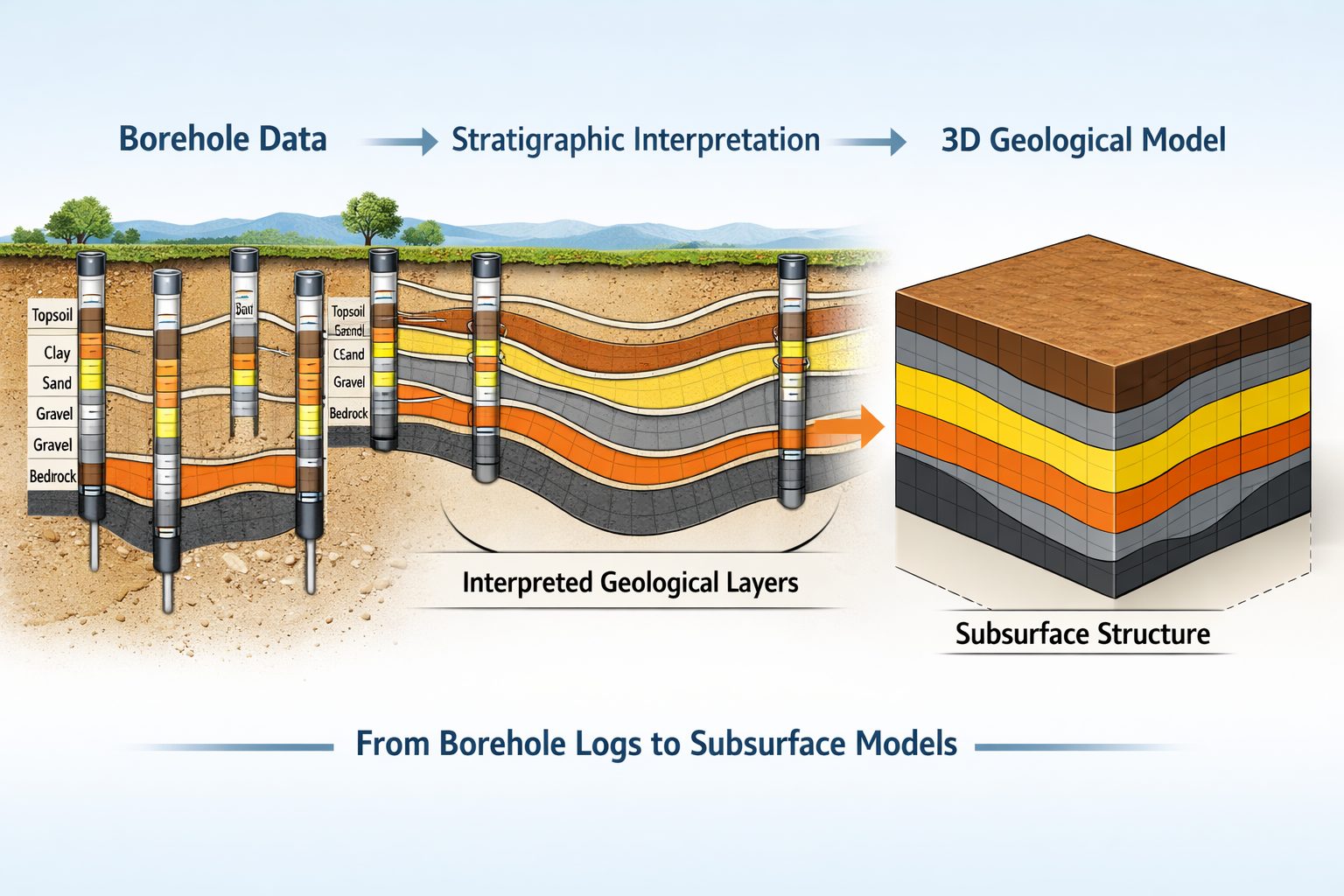
Subsurface investigations generate large volumes of data that must be organized, analyzed, and interpreted to understand geological conditions. Borehole drilling programs produce detailed records of subsurface materials, including lithological descriptions, sampling intervals, laboratory test results, and groundwater measurements. These datasets form the foundation for geological modeling, which is used to visualize and interpret subsurface structures.
Historically, borehole databases and geological modeling software have often existed as separate systems. Borehole data may be stored in spreadsheets or dedicated databases, while geological models are created using specialized modeling software. Transferring data between these systems can be time-consuming and error-prone.
Connecting borehole databases with geological modeling software provides a more efficient and reliable approach to managing subsurface information. Integrated workflows allow geologists and engineers to move seamlessly from raw borehole data to geological interpretation and 3D modeling.
This article explores how borehole databases and geological modeling software work together, the benefits of integration, and best practices for building efficient subsurface data workflows.
The Importance of Borehole Data in Geological Modeling
Boreholes are one of the most important sources of subsurface information. By drilling into the ground and recording geological conditions at different depths, boreholes provide direct observations of subsurface materials.
Typical borehole records include:
- Borehole coordinates and elevation
- Drilling methods and equipment
- Lithological descriptions
- Sampling intervals
- Standard Penetration Test (SPT) values
- Core recovery and rock quality designation (RQD)
- Laboratory test results
- Groundwater measurements
These datasets provide the raw information used to interpret geological conditions.
Geological models are built by combining data from multiple boreholes to represent how subsurface layers extend between sampling locations. Without accurate borehole data, geological models cannot reliably represent real subsurface conditions.
What Is a Borehole Database?
A borehole database is a structured system designed to store and manage drilling and sampling data.
Unlike spreadsheets or simple tables, borehole databases use relational structures that organize data into multiple linked tables. These tables typically include:
- borehole location information
- lithology intervals
- sampling records
- field test results
- laboratory data
- groundwater measurements
Each dataset is linked through a common borehole identifier, allowing multiple types of information to be associated with the same location and depth intervals.
Borehole databases provide several advantages:
- standardized data structures
- validation rules that reduce errors
- efficient data retrieval
- long-term data storage and reuse
By organizing subsurface data in a structured database, engineering firms and geological teams can maintain reliable datasets that support modeling and analysis.
What Is Geological Modeling Software?
Geological modeling software is used to interpret subsurface data and create visual representations of geological structures.
These models may include:
- geological cross-sections
- stratigraphic surfaces
- 3D geological volumes
- groundwater surfaces
- structural features such as faults
Geological modeling software typically uses borehole data as the primary input. By analyzing the depth and distribution of geological units across multiple boreholes, the software can interpolate surfaces and create continuous geological models.
These models help engineers and geologists understand how subsurface materials vary across a site or region.
Challenges When Databases and Modeling Software Are Separate
When borehole databases and geological modeling software are not connected, several challenges arise.
Manual Data Transfers
Data often must be exported from the borehole database and then imported into the modeling software. This process may involve converting file formats or restructuring data tables.
Manual data transfers increase the risk of errors and inconsistencies.
Version Control Issues
When data is copied between systems, multiple versions of the same dataset may exist.
For example, a geological model may be based on an older dataset that does not include recently added boreholes or corrected lithology records.
Inefficient Workflows
Geologists may spend significant time preparing datasets before they can begin modeling.
Tasks such as formatting borehole tables, correcting depth intervals, and standardizing lithology codes can delay analysis.
Limited Collaboration
Separate systems can make it difficult for teams to share data.
Geotechnical engineers, geologists, and GIS specialists may each work with different datasets, reducing the efficiency of multidisciplinary projects.
Benefits of Connecting Borehole Databases and Modeling Software
Integrating borehole databases with geological modeling software creates a more efficient workflow for subsurface analysis.
Seamless Data Flow
When the database and modeling software are connected, borehole data can be accessed directly by the modeling tools.
This eliminates the need for manual exports and imports.
Real-Time Data Updates
Changes made in the borehole database can automatically update the geological model.
For example, if new boreholes are added or lithology records are corrected, the model can be regenerated using the updated dataset.
Improved Data Quality
Integration encourages the use of standardized data structures and validation rules.
Because the geological model depends on the database, maintaining high-quality borehole data becomes essential.
Faster Modeling Workflows
Geologists can focus on interpretation rather than data preparation.
Automated data connections allow modeling workflows to begin immediately once borehole data is available.
Better Collaboration
Integrated platforms allow multiple specialists to work with the same dataset.
Geologists, geotechnical engineers, and GIS professionals can access the same borehole database while contributing to different aspects of the project.
Linking Borehole Databases to Geological Models
Connecting borehole databases with modeling software requires several key components.
Standardized Data Structures
Borehole data must be stored in a structured format that modeling software can interpret.
Important fields typically include:
- borehole identifier
- coordinates
- ground surface elevation
- lithology intervals
- depth measurements
- geological unit codes
Standardized coding systems help ensure that geological units are interpreted consistently across the dataset.
Database Connectivity
Many geological modeling tools support direct connections to relational databases.
This connection allows the software to query borehole data dynamically.
Instead of importing static files, the modeling software retrieves data directly from the database.
Data Validation and Quality Control
Before data is used in modeling, it should be validated to ensure accuracy.
Common validation checks include:
- verifying coordinate systems
- confirming depth intervals do not overlap
- ensuring lithology codes follow standardized classifications
- checking for duplicate borehole records
High-quality data leads to more reliable geological models.
Creating Geological Cross-Sections from Borehole Data
Cross-sections are one of the most common outputs generated from borehole databases.
When the database is connected to modeling software, cross-sections can be generated automatically.
Typical cross-section workflows include:
- Selecting a section line across the site
- Projecting boreholes onto the section
- Displaying lithology intervals and sampling data
- Interpreting geological contacts between boreholes
Because the cross-section is linked to the database, it can be updated whenever new data becomes available.
Interpolating Geological Surfaces
Geological models often require interpolation of surfaces between boreholes.
Examples include:
- bedrock elevation surfaces
- top of clay layers
- groundwater tables
- thickness of geological units
Modeling software uses interpolation algorithms to generate continuous surfaces based on discrete borehole data.
When the borehole database is connected directly to the modeling software, these surfaces can be recalculated quickly as new data is added.
Building 3D Geological Models
Three-dimensional modeling is increasingly used to represent complex subsurface conditions.
3D models allow users to visualize:
- geological layers
- structural features
- groundwater surfaces
- engineering properties
These models are built by combining borehole data with interpreted geological surfaces.
Direct database connections ensure that the model always reflects the most recent borehole information.
Integration with GIS Systems
Geological modeling workflows often involve GIS mapping tools.
GIS systems provide spatial context by displaying borehole locations alongside other geographic data, such as:
- topography
- infrastructure
- geological maps
- environmental features
When borehole databases are integrated with both modeling software and GIS systems, users can seamlessly move between spatial analysis and geological interpretation.
Applications in Engineering and Environmental Projects
Connecting borehole databases with geological modeling software supports many types of projects.
Infrastructure Engineering
Large infrastructure projects require detailed understanding of subsurface conditions.
Integrated data workflows help engineers interpret soil and rock conditions along transportation corridors, tunnels, and foundations.
Environmental Investigations
Environmental consultants use borehole data to understand soil stratigraphy and groundwater flow.
Integrated modeling tools help track contaminant migration and evaluate remediation strategies.
Mining and Resource Exploration
Mining companies rely on drill hole data to build geological models of mineral deposits.
Connecting drill hole databases with modeling software improves the efficiency of exploration programs.
Hydrogeological Studies
Hydrogeologists use borehole data and monitoring wells to study groundwater systems.
Geological models help visualize aquifers, confining layers, and groundwater flow pathways.
Future Trends in Subsurface Data Integration
Advances in digital technology are improving how borehole databases and modeling software interact.
Cloud-Based Data Platforms
Cloud-based systems allow teams to access borehole databases and geological models from anywhere.
These platforms improve collaboration between geographically distributed teams.
Automated Data Import
Drilling equipment, laboratory systems, and monitoring sensors are increasingly capable of exporting digital data directly into databases.
Automated data import reduces manual entry and improves data accuracy.
Advanced Visualization Tools
Improved 3D visualization and virtual reality technologies may allow engineers and geologists to explore subsurface models more interactively.
Conclusion
Connecting borehole databases with geological modeling software creates a powerful workflow for managing and interpreting subsurface investigation data. By linking structured borehole databases with modeling tools, engineers and geologists can move seamlessly from raw drilling records to detailed geological interpretations.
Integrated systems improve data quality, streamline workflows, and enable real-time updates to geological models as new data becomes available. These capabilities are essential for modern engineering, environmental, and geological projects that rely on accurate understanding of subsurface conditions.
As digital technologies continue to evolve, the integration of borehole databases and geological modeling software will play an increasingly important role in supporting efficient and reliable subsurface data management.
Learn more about our Solutions
- GaeaSynergy Platform for Geoscientific Analysis
- Borehole and Well Log Data Management
- Cross Sections and Sub-surface Visualization
- Geotechnical Data Management System
- Environmental Data Management System
Related Articles
- GaeaSynergy: Integrated Geological, Geotechnical, and Environmental Data Management Platform
- The Complete Guide to Borehole Data Solutions
- The Complete Guide to Geotechnical Data Management
- The Complete Guide to Environmental Data Management
- Geological Cross-Sections from Borehole Data: A Complete Engineering Guide
- Integrated Geological and Geotechnical Data Platforms
- Why Engineering Firms Need Integrated Subsurface Data Platforms
- Managing Geological, Geotechnical, and Environmental Data in One Platform
- Digital Platforms for Subsurface Investigation Data
- GIS Integration in Geological and Geotechnical Data Platforms
- Data Governance in Geological and Engineering Platforms
- The Future of Integrated Subsurface Data Platforms
- How Artificial Intelligence Is Transforming Geotechnical & Environmental Engineering
- Beyond 2D: Integrating Boring Logs with 3D Models for Complex Infrastructure Projects
- Protecting Our Water: Monitoring Contaminant Plumes Through Real-Time Stratigraphic Mapping
- Strategic Data Management in GaeaSynergy
- Seamless Data Flow: Mastering Import and Export in GaeaSynergy
- Mapping the Site: GIS and Spatial Data Management in GaeaSynergy
- Comprehensive Site Intelligence: Integrating Subsurface Data and Infrastructure in GaeaSynergy 3D
- Visualizing the Invisible: 3D Above and Below Ground Structures in GaeaSynergy
- Mastering Subsurface Visualization: Contouring and Gridding in GaeaSynergy
- From Data to Discovery: Visualizing the Subsurface with GaeaSynergy
- GAEA Technologies Software in the Oil & Gas Industry
- Beyond the Surface: How GAEA Technologies Software Powers Modern Mining
- Winning More Bids: Using High-Resolution Subsurface Visualization to Demonstrate Project Certainty
- Selecting the Right Gridding Algorithm for Your Contour Map
- The Science of Doubt: How to Quantify and Visualize Subsurface Uncertainty in Geological Models
- Geoscientific Analysis: Key Uses and Benefits