
Introduction
Geological cross-sections are one of the most fundamental tools used in geotechnical engineering, hydrogeology, environmental consulting, and mining exploration. They provide a visual representation of subsurface geology by correlating soil and rock layers between boreholes. By transforming vertical borehole logs into horizontal interpretations, cross-sections allow engineers and geologists to understand how geological layers extend beneath a site.
Despite their widespread use, constructing accurate cross-sections requires careful data preparation, geological interpretation, and an understanding of subsurface variability. Borehole logs contain discrete observations collected during drilling, but the geological layers between those boreholes must be interpreted. This interpretation process introduces uncertainty that must be managed through good data practices and sound geological reasoning.
Modern geological software has greatly improved the efficiency of creating cross-sections. Programs can now automatically import borehole databases, interpolate geological layers, and generate digital visualizations of subsurface stratigraphy. However, these tools depend entirely on the quality of the borehole data used as input. Poorly structured databases, inconsistent lithology descriptions, or incorrect coordinates can lead to misleading cross-sections.
This guide explains how geological cross-sections are constructed from borehole data, the challenges involved in interpreting subsurface geology, and the best practices engineers and geologists should follow to produce reliable cross-section models.
What Is a Geological Cross-Section?
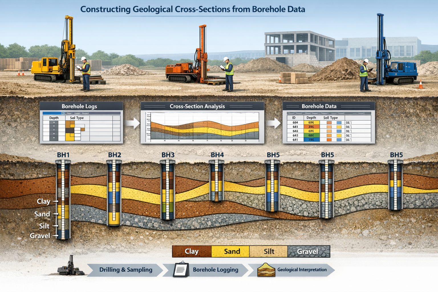
A geological cross-section is a vertical slice through the Earth that illustrates the arrangement of geological layers beneath the ground surface. Cross-sections are typically constructed along a line connecting multiple boreholes drilled during site investigations.
Each borehole provides a vertical record of soil and rock layers encountered during drilling. These layers are recorded in borehole logs that include information such as:
- lithology descriptions
- depth intervals
- soil classification
- groundwater observations
- sample test results
When multiple boreholes are aligned along a section line, geologists correlate the layers between boreholes to reconstruct subsurface stratigraphy.
The resulting cross-section provides insight into the geometry of geological layers, including:
- layer thickness
- layer continuity
- geological contacts
- structural features
Cross-sections help engineers understand the geological framework beneath a site, which is critical for infrastructure design, environmental assessment, and groundwater analysis.
How Borehole Data Is Used to Create Cross-Sections
The process of creating a geological cross-section begins with borehole drilling. During a site investigation, multiple boreholes are drilled across an area to collect information about subsurface conditions.
Each borehole log records the sequence of geological materials encountered during drilling. These logs typically include depth intervals and descriptions of soil or rock types.
To construct a cross-section, the boreholes must first be positioned along a section line. The distance between boreholes is determined using their spatial coordinates, which are usually recorded using GPS or surveying equipment.
Once the boreholes are aligned along the section line, the geological layers within each borehole can be plotted vertically. The next step is to interpret how those layers connect between boreholes.
Geologists examine the lithology descriptions, stratigraphic context, and regional geology to determine how layers extend between boreholes. They then draw correlations between similar layers, forming continuous geological units across the cross-section.
This interpretation process is one of the most important steps in cross-section construction. While software tools can assist with visualization, the interpretation itself relies heavily on geological expertise.
The Importance of Borehole Spacing
The reliability of a geological cross-section depends heavily on borehole spacing. The greater the distance between boreholes, the more uncertainty exists about what lies between them.
When boreholes are closely spaced, geologists can correlate layers with greater confidence. Closely spaced boreholes provide detailed information about changes in layer thickness, sediment transitions, and structural features.
However, in many projects boreholes are spaced widely due to budget constraints. In such cases, the geological interpretation between boreholes becomes more speculative.
Large gaps between boreholes may hide important geological features such as:
- sediment lenses
- buried channels
- fault structures
- layer pinch-outs
Understanding the limitations imposed by borehole spacing is essential when interpreting cross-sections.
Challenges in Cross-Section Interpretation
Interpreting subsurface geology from borehole data presents several challenges.
One of the most common issues is lithological variability. Geological materials rarely form perfectly uniform layers. Instead, they often vary laterally due to changes in depositional environments.
For example, a sand layer encountered in one borehole may transition into silty sand or clay in another borehole only a short distance away. Determining how these materials relate to each other requires careful interpretation.
Another challenge is the presence of pinch-outs. A pinch-out occurs when a geological layer gradually thins and disappears between boreholes. If pinch-outs are not recognized, cross-section software may incorrectly connect layers.
Data quality issues can also complicate cross-section interpretation. Inconsistent lithology naming, incorrect depth intervals, or missing data can produce misleading correlations.
Proper data preparation is therefore essential before importing borehole logs into cross-section software.
Preparing Borehole Databases for Cross-Sections
Modern geological software relies on structured databases to generate cross-sections. Borehole data must be organized into clearly defined tables before it can be imported into visualization tools.
Typical borehole databases include two main datasets.
The first is the borehole collar table, which contains location information for each borehole. This table typically includes:
- borehole ID
- coordinates
- ground elevation
- drilling date
The second dataset is the lithology table, which contains depth intervals describing the geological layers encountered in each borehole.
Lithology tables usually contain fields such as:
- borehole ID
- from depth
- to depth
- lithology description
Ensuring these datasets are properly structured allows cross-section software to correctly position boreholes and reconstruct geological layers.
Digital Cross-Section Software
Advances in geological software have transformed how cross-sections are created. Instead of manually drawing cross-sections on paper, engineers can now generate digital cross-sections directly from borehole databases.
These tools allow users to:
- import borehole data
- align boreholes along section lines
- correlate geological layers
- visualize subsurface stratigraphy
Some programs can also generate fence diagrams, which combine multiple cross-sections to form a three-dimensional representation of subsurface geology.
Digital tools improve efficiency and allow geologists to quickly test different interpretations of geological structure.
Engineering Applications of Geological Cross-Sections
Geological cross-sections play a critical role in many engineering disciplines.
In geotechnical engineering, cross-sections help engineers evaluate soil conditions beneath buildings, roads, and bridges. Understanding the distribution of soil layers is essential for designing foundations and assessing settlement risks.
In environmental investigations, cross-sections are used to understand groundwater flow and contaminant migration. By visualizing subsurface stratigraphy, hydrogeologists can identify permeable layers that may transport contaminants.
In mining exploration, cross-sections help geologists evaluate ore deposits and plan extraction strategies.
Because cross-sections provide insight into subsurface conditions, they are often used to communicate geological information to engineers, planners, and regulators.
Best Practices for Creating Accurate Cross-Sections
Producing reliable cross-sections requires careful attention to data quality and interpretation.
Some best practices include:
- ensuring borehole coordinates are accurate
- standardizing lithology descriptions
- verifying depth intervals
- reviewing borehole spacing
- considering regional geology
Cross-sections should also be reviewed by experienced geologists to ensure the interpretation is consistent with known geological conditions.
Combining multiple cross-sections across a site can also improve understanding of subsurface structure.
Conclusion
Geological cross-sections are essential tools for visualizing subsurface conditions in engineering and environmental projects. By correlating borehole logs across a site, geologists can reconstruct the arrangement of soil and rock layers beneath the ground surface.
Although modern software has simplified cross-section generation, the accuracy of these models still depends on careful data preparation and sound geological interpretation. Borehole databases must be properly structured, lithology descriptions must be consistent, and borehole coordinates must be accurate.
Understanding the limitations of borehole data—particularly the uncertainty between boreholes—is also critical when interpreting cross-sections.
When constructed carefully, geological cross-sections provide powerful insight into subsurface geology and support better decision-making in engineering, environmental management, and resource exploration.
Learn more about our Solutions
- GaeaSynergy Platform for Geoscientific Analysis
- WinLoG Borehole and Well Log Data Management
- WinFence Cross-section and Fence Diagram Visualization
Related Articles
- GaeaSynergy: Integrated Geological, Geotechnical, and Environmental Data Management Platform
- Subsurface Visualization: Turning Borehole Data into Clear Geological Insight
- Geological Modeling Software and Tools: Digital Platforms for Subsurface Interpretation
- Common Mistakes When Creating Geological Cross-Sections from Borehole Data
- How Borehole Spacing Affects Geological Cross-Section Accuracy
- Preparing Borehole Databases for Cross-Section Software
- How Lithological Correlation Works Between Boreholes
- Understanding Fence Diagrams in Geological Modeling
- Common Data Errors in Borehole Databases and How to Fix Them
- Using Geological Cross-Sections in Geotechnical Engineering
- Borehole Coordinate Systems and Mapping for Geological Modeling
- Depth vs Elevation in Borehole Databases for Geological Modeling
- Interpreting Geological Variability Between Boreholes
- Building Geological Cross-Sections from Borehole Data: A Step-by-Step Workflow
- How Geological Software Interpolates Subsurface Layers Between Boreholes
- Borehole Data Visualization Techniques for Geological Modeling
- Managing Large Borehole Data Sets in Engineering Projects
- Understanding Pinch-Outs and Missing Geological Layers in Subsurface Interpretation
- Digital Workflows for Geotechnical Data: Managing Borehole Information from Field to Model
- Best Practices for Borehole Logging and Interpretation in Geological and Geotechnical Investigations
- Subsurface Modeling for Engineering Projects: Interpreting Geological Conditions Beneath Infrastructure
- Borehole Databases and Geological Data Management: A Complete Guide for Engineers and Geologists
- Fence Diagrams and 3D Geological Visualization: Understanding Subsurface Structure from Borehole Data
- The Geologist’s Role In CCUS: Using Cross-Section Software To Map Carbon Sequestration Integrity
- Integrating WinLoG Data into WinFence: A Complete Guide
- Visualizing the Subsurface: A Guide to WinFence
- WinFence vs. QuickFence vs. RockWorks: The Ultimate Geological Cross-section Software Comparison
- Seconds, Not Hours: Generating Regional Cross-Sections at Scale with Automated Top-Picking
- Visualizing the Subsurface: A Guide to WinFence Cross-Section Software
- Navigating The Underground: How 3D Cross-Sections Minimize Risk In Tunneling And Foundation Design
- Maximizing Project ROI: How Digital Cross-Sections Cut Site Investigation Costs by 30%
- Geologic Cross-Sections: Essential Uses and Tips