
Introduction
Borehole data forms the foundation of most subsurface investigations in geotechnical engineering, hydrogeology, environmental consulting, mining exploration, and infrastructure development. Every borehole drilled during a site investigation provides valuable information about the geology beneath the surface, including soil layers, sediment composition, groundwater conditions, and rock formations.
However, collecting borehole data is only the first step in understanding subsurface conditions. To extract meaningful insights from drilling programs, this information must be carefully organized, standardized, and managed within structured borehole databases. Without proper data management, even large volumes of borehole information can become difficult to interpret or use in geological modeling.
Modern engineering and geological workflows increasingly rely on digital borehole databases that allow professionals to store, analyze, and visualize subsurface information. These databases support tasks such as generating geological cross-sections, constructing fence diagrams, modeling subsurface stratigraphy, and performing geotechnical analysis.
This guide explores how borehole databases are structured, why proper geological data management is essential, and the best practices engineers and geologists should follow when preparing borehole datasets for interpretation and modeling.
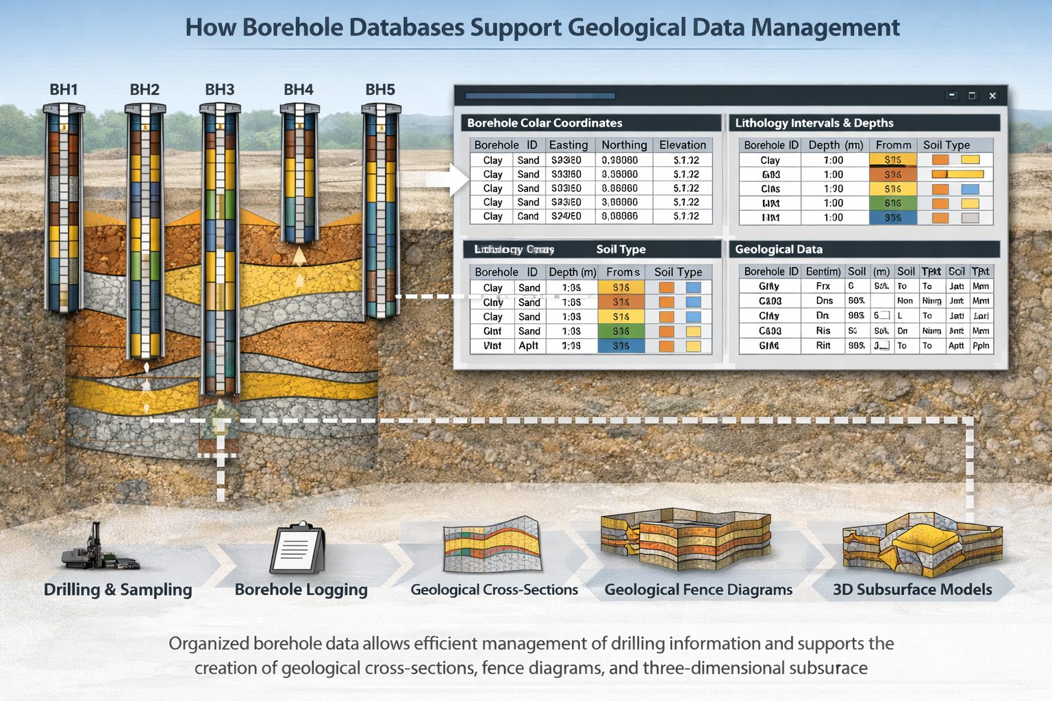
What Is a Borehole Database?
A borehole database is a structured digital system used to store and manage information collected from drilling investigations. Instead of storing borehole logs as individual documents or spreadsheets, a database organizes the data into standardized tables that allow efficient storage, retrieval, and analysis.
Each borehole drilled during a project generates multiple types of information. These may include location data, lithological descriptions, sample results, laboratory tests, and groundwater observations. A well-designed borehole database organizes all of this information in a structured format so it can be used in engineering analysis and geological interpretation.
The key advantage of a database system is that it allows users to manage large numbers of boreholes across multiple projects while maintaining data consistency and accuracy.
In large infrastructure or environmental projects, it is not uncommon for investigations to involve hundreds or even thousands of boreholes. Managing this volume of data without a structured database quickly becomes inefficient and prone to error.
A well-designed borehole database ensures that subsurface information remains organized, searchable, and ready for integration with geological modeling software.
Why Borehole Data Management Matters
Proper borehole data management is essential for accurate geological interpretation and engineering decision-making. Poorly organized datasets can lead to misinterpretations of subsurface conditions, which may have serious consequences for infrastructure design or environmental remediation projects.
One of the most common problems encountered in poorly managed datasets is inconsistent lithology descriptions. Field geologists often record soil or rock types using slightly different terminology. For example, one borehole log may describe a layer as “silty sand,” while another describes a similar material as “sand with silt.”
While these descriptions may refer to similar materials, geological software may interpret them as separate units unless the terminology is standardized. This can lead to incorrect correlations between boreholes when generating cross-sections or subsurface models.
Another common issue involves incorrect depth intervals. If depth measurements overlap or contain gaps, geological modeling software may produce unrealistic results. These errors often occur when borehole logs are manually transcribed into digital formats.
Coordinate errors are another significant concern. Borehole locations must be recorded accurately so they can be positioned correctly within geological models. Even small coordinate errors can distort cross-section geometry or cause layers to appear in incorrect locations.
By implementing proper data management practices, engineers and geologists can ensure that borehole datasets remain reliable and suitable for interpretation.
Core Components of a Borehole Database
Although borehole database structures may vary between organizations, most systems contain several core tables that store different types of information.
Borehole Collar Table
The collar table contains basic information about each borehole location. This table typically includes:
- Borehole ID
- Easting coordinate
- Northing coordinate
- Ground surface elevation
- Drilling date
- Project name
This information allows software to place each borehole correctly within a spatial framework.
The accuracy of collar data is extremely important. If borehole coordinates are incorrect, the spatial relationships between boreholes will be distorted.
Lithology Table
The lithology table records the geological materials encountered during drilling. Each entry describes a specific interval within a borehole.
Typical fields include:
- Borehole ID
- From depth
- To depth
- Lithology description
- Soil classification
- Comments or notes
This table forms the backbone of geological interpretation. Cross-section software uses lithology intervals to reconstruct the subsurface layers between boreholes.
Sample and Laboratory Data
Many boreholes include samples collected for laboratory testing. These samples may provide important geotechnical or environmental information.
Laboratory datasets may include:
- grain size distribution
- moisture content
- shear strength
- Atterberg limits
- hydraulic conductivity
These results are often stored in separate tables linked to the borehole ID.
Groundwater Observations
Groundwater conditions are frequently recorded during drilling or monitoring activities. Water levels and flow conditions can influence engineering design and environmental assessments.
Typical groundwater data includes:
- water table depth
- monitoring well measurements
- seasonal water level variations
Including this information within borehole databases allows hydrogeologists to analyze groundwater behavior across a site.
Standardizing Geological Descriptions
One of the most important tasks in borehole database management is standardizing geological descriptions.
Field logs often contain detailed descriptions written by geologists during drilling operations. While these descriptions provide valuable observations, they can vary widely in terminology.
For example, similar materials may be described as:
- fine sand
- medium sand
- silty sand
- sand with silt
If these descriptions are used directly in a database without standardization, cross-section software may treat them as separate lithological units.
To avoid this issue, many organizations adopt standardized lithology categories. These categories group similar materials into broader units such as:
- clay
- silt
- sand
- gravel
- bedrock
More detailed descriptions can still be preserved in secondary fields, but standardized categories allow software to correlate layers more easily.
Data Quality Control
Quality control is a critical step in borehole database management. Before borehole data is used in geological interpretation or modeling, it should be carefully reviewed for errors.
Common quality control checks include:
- verifying borehole coordinates
- checking ground surface elevations
- confirming depth interval continuity
- identifying duplicate records
- reviewing lithology naming conventions
Automated scripts or spreadsheet formulas can often identify these issues quickly.
Large organizations sometimes implement formal data validation procedures to ensure that new borehole records meet quality standards before being added to the database.
Integrating Borehole Databases with Geological Software
Modern geological software platforms rely heavily on borehole databases. Instead of manually drawing geological cross-sections, engineers can now import borehole data directly into visualization tools.
These tools can automatically generate:
- geological cross-sections
- fence diagrams
- stratigraphic models
- volumetric calculations
However, these capabilities depend entirely on the quality of the underlying data.
If borehole databases contain inconsistent lithology descriptions or incorrect depth intervals, the resulting models may produce misleading interpretations.
Preparing borehole databases properly before importing them into software ensures that geological layers are interpreted correctly.
Managing Large Borehole Data Sets
As infrastructure projects grow in scale, borehole datasets are becoming increasingly large. Major transportation projects, mining operations, and environmental remediation programs may involve thousands of boreholes collected over many years.
Managing large datasets requires efficient database systems and standardized data structures.
Some organizations implement centralized geological databases that store information from multiple projects. These systems allow engineers and geologists to access historical borehole data when evaluating new sites.
Centralized data systems also support long-term environmental monitoring programs, where groundwater or contaminant data may be collected over decades.
Automation and Digital Workflows
Advances in digital technology are transforming how borehole data is managed. Many organizations are adopting automated workflows that streamline the process of importing, cleaning, and organizing borehole datasets.
These systems can automatically:
- standardize lithology descriptions
- detect depth interval errors
- validate coordinates
- generate cross-sections
- produce geological models
Automation reduces the risk of human error and allows engineers to focus on interpreting geological patterns rather than managing raw data.
Future Trends in Geological Data Management
The future of borehole database management is likely to involve greater integration with digital modeling platforms and cloud-based data systems.
Emerging technologies such as digital twins and real-time monitoring systems may allow subsurface conditions to be continuously updated as new data becomes available.
Cloud-based databases also enable teams working on large projects to share geological information more efficiently. Engineers, geologists, and environmental scientists can collaborate using centralized data platforms rather than relying on disconnected spreadsheets.
As infrastructure and environmental projects become more complex, robust geological data management systems will become increasingly important.
Best Practices for Borehole Database Management
Engineers and geologists can improve the reliability of their borehole datasets by following several best practices.
First, establish standardized naming conventions for boreholes and lithology categories. Consistency in naming reduces confusion and improves compatibility with geological software.
Second, verify borehole coordinates and elevations carefully. Accurate spatial information is essential for constructing reliable cross-sections and subsurface models.
Third, perform regular data quality checks. Identifying errors early prevents problems later during geological interpretation.
Finally, organize borehole data within structured database systems rather than relying on scattered spreadsheets or documents.
Conclusion
Borehole databases are essential tools for managing the vast amounts of subsurface information collected during geological investigations. By organizing borehole logs into structured datasets, engineers and geologists can efficiently analyze subsurface conditions and generate accurate geological interpretations.
Proper borehole data management improves the reliability of cross-sections, geological models, and engineering analyses. Standardizing lithology descriptions, verifying coordinates, and performing thorough quality control checks all contribute to more accurate subsurface interpretations.
As digital geological modeling continues to evolve, well-structured borehole databases will become even more important. Engineers and geologists who invest in robust data management practices will be better equipped to understand subsurface conditions and support safe, efficient infrastructure development.
Learn more about our Solutions
- GaeaSynergy Platform for Geoscientific Analysis
- WinLoG Borehole and Well Log Data Management
- WinFence Cross-section and Fence Diagram Visualization
Related Articles
- Geological Cross-Sections from Borehole Data: A Complete Engineering Guide
- Geological Modeling Software and Tools: Digital Platforms for Subsurface Interpretation
- Common Mistakes When Creating Geological Cross-Sections from Borehole Data
- How Borehole Spacing Affects Geological Cross-Section Accuracy
- Preparing Borehole Databases for Cross-Section Software
- How Lithological Correlation Works Between Boreholes
- Understanding Fence Diagrams in Geological Modeling
- Common Data Errors in Borehole Databases and How to Fix Them
- Using Geological Cross-Sections in Geotechnical Engineering
- Borehole Coordinate Systems and Mapping for Geological Modeling
- Depth vs Elevation in Borehole Databases for Geological Modeling
- Interpreting Geological Variability Between Boreholes
- Building Geological Cross-Sections from Borehole Data: A Step-by-Step Workflow
- How Geological Software Interpolates Subsurface Layers Between Boreholes
- Borehole Data Visualization Techniques for Geological Modeling
- Managing Large Borehole Data Sets in Engineering Projects
- Understanding Pinch-Outs and Missing Geological Layers in Subsurface Interpretation
- Digital Workflows for Geotechnical Data: Managing Borehole Information from Field to Model
- Best Practices for Borehole Logging and Interpretation in Geological and Geotechnical Investigations
- Subsurface Modeling for Engineering Projects: Interpreting Geological Conditions Beneath Infrastructure