Categories
Select Category
Automated environmental reporting (1)
Borehole Data Management (96)
Borehole Data Solutions (21)
Borehole Databases (19)
Boring and well log software (4)
Contaminant Transport Modeling (12)
Contaminant Transport Modeling (68)
Contaminant transport modelling and landfill design (2)
Cross-section and fence diagram software (1)
Cross-Sections & Subsurface Visualization (9)
Drilling and Sampling (30)
Environmental Data Management (32)
Environmental Data Management (4)
Environmental data management system (2)
Environmental Reporting & Automation (3)
Environmental Site Assessment Automation (51)
Environmental Site Assessments (34)
Frequently Asked Questions (26)
GaeaSynergy Platform (31)
GaeaSynergy Platform (19)
Geoscience Data Digitization (34)
Geoscientific analysis platform (3)
Geotechnical Data Management (6)
Geotechnical Data Management (33)
Geotechnical data management system (3)
Licensing and Registration (2)
MIGRATE Examples (13)
News Releases (18)
Our Story (8)
POLLUTE Examples (20)
POLLUTE vs MIGRATE (5)
QA/QC (32)
Security and Governance (14)
Subsurface Visualization (22)
Training and Tutorials (75)
Tags
Select Tag
1D Modeling (1)
2026 EPA PFAS standards (1)
2D Dispersion (1)
2D modeling (1)
2D seismic interpretation (1)
3D 4D modeling (1)
3D Cross-Sections (1)
3D Display (1)
3D fence diagrams (1)
3D geological modeling (1)
3D geotechnical modeling (1)
3D modeling (1)
3D modeling (2)
3D subsurface mapping (1)
3D visualization (2)
AAI (1)
aboveground cover (1)
Access Control (3)
Access database (1)
activity and use limitations (1)
adjacent properties (1)
Administrator (1)
Adsorption (1)
advanced geotechnical logging (1)
advanced modeling software (1)
advection (1)
advection dispersion (2)
advection-dispersion (1)
advection-dispersion equation. (1)
advective dispersive transport (2)
aerial environmental due diligence (1)
aerial photographs environmental (1)
agriculture tools (1)
AGS (2)
AGS 4 (1)
AGS compatibility (1)
AGS data (3)
AGS file export (1)
AGS file import (1)
AGS files (1)
AGS format (2)
AGS import (1)
AGS standard (1)
AGS validation (1)
AGS workflow (1)
AI (1)
AI borehole logs (1)
AI borehole QA QC (1)
AI environmental analysis (1)
AI geoscience data (3)
AI governance (1)
AI in engineering (1)
AI in geoscience (1)
AI readiness (1)
AI ready geoscience data (1)
AI security (1)
AI seismic processing (1)
amendment workflow (1)
analog map conversion (1)
analog seismic data (1)
analog seismic records (1)
analysis plan (1)
analytical modeling (2)
Analytical Solution (3)
and 3D subsurface modeling used in geotechnical and environmental investigations. (1)
and material estimating in field investigations (1)
and recommendations for remediation (1)
Android app (1)
Android boring log app (1)
Android data collection (1)
Android Field App (1)
Android soil testing (1)
Android tablets (1)
annual maintenance (2)
annulus (1)
anomaly detection (2)
approval reset (1)
approval workflow (2)
approved boreholes (1)
aquifer (2)
aquifer analysis (1)
Aquifer Mixing (1)
aquifer modeling (1)
aquifer monitoring (1)
Archive Conversion (1)
artificial intelligence (1)
artificial intelligence geology (1)
asphalt density (1)
assay QA QC (1)
Asset Preservation (1)
ASTM D1557 (1)
ASTM D2434 (1)
ASTM D2487 (1)
ASTM D422 (1)
ASTM D4318 (1)
ASTM D5092 (1)
ASTM D698 (1)
ASTM E1527 reporting (1)
ASTM E1527-21 (12)
ASTM E1903 (2)
ASTM Phase I ESA (1)
ASTM standards (4)
ASTM standards. (1)
ASTM vs CSA (1)
attenuation (1)
Atterberg Limits (2)
audit compliance (1)
audit logs (1)
audit trail (3)
audit trail compliance (1)
audit trails (5)
auditable data process (1)
AULs (1)
automate borehole logs (1)
automate geotechnical reports (1)
Automated Borehole Logs (1)
automated curve recognition (1)
automated data merge (1)
automated environmental reporting (4)
automated environmental reporting software (1)
automated environmental site assessments (1)
automated notifications (2)
automated Phase I ESA reporting (1)
automated report generation (1)
automated reporting (5)
automated top-picking (1)
automation (4)
backup and restore (1)
Base Outflow Velocity (1)
bentonite grout (1)
bentonite seal (1)
BIM integration (3)
Biological Decay (1)
blow counts (1)
borehole approval workflow (1)
borehole audit trail (1)
borehole correlation (1)
borehole cross section (9)
borehole cross section output (1)
Borehole Data (48)
Borehole Data Borehole Data Management Geotechnical Data Geotechnical Database Subsurface Data (1)
borehole data entry (1)
borehole data governance (1)
borehole data import (1)
borehole data management (43)
borehole data management system (1)
borehole data migration (1)
borehole data processing (1)
Borehole Data Quality (2)
Borehole Data Standards (1)
borehole data structuring (1)
Borehole Data Validation (1)
borehole data visualization (9)
borehole database (27)
borehole database software (10)
borehole diagram (1)
Borehole Drilling (1)
borehole GIS integration (1)
borehole location mapping (1)
Borehole Locations (1)
borehole log (1)
borehole log digitization (1)
borehole log forms (1)
borehole log generation (1)
borehole log generation software (1)
borehole log header missing (1)
borehole logging (57)
borehole logging alerts (1)
borehole logging app (1)
borehole logging automation (1)
borehole logging efficiency (1)
borehole logging software (32)
borehole logging software tips (1)
borehole logging templates (1)
borehole logs (27)
borehole procedure (1)
borehole project import (1)
borehole qa qc (10)
Borehole QA/QC (4)
Borehole Quality Assurance (1)
Borehole Quality Control (1)
borehole records (1)
borehole report automation (1)
borehole report software (1)
borehole reports (3)
borehole review (1)
borehole revisions (1)
borehole risks (1)
borehole sampling (1)
borehole software (10)
borehole validation (4)
borehole vs well (1)
Borehole Workflow (4)
Boreholes (1)
boring definition geotech (1)
boring log (1)
boring log database (1)
boring log software (1)
boring logs (2)
breakthrough curve (4)
Bridge Construction (1)
brownfield (1)
Brownfield Development (1)
brownfield redevelopment (5)
brownfield redevelopment assessment (1)
brownfield site assessment (1)
building condition ESA (1)
building permits environmental (1)
Building Structures (1)
buildings (1)
business efficiency (1)
business software (2)
bypassed pay zones (1)
calculated columns (1)
Calibrating PID (1)
Call Before You Dig (1)
Canada vs USA (1)
Carbon Capture (3)
Carbon Sequestration (1)
CCS (1)
CCUS (1)
centralized data management (1)
centralized database (1)
CERCLA (2)
CERCLA liability protection (1)
CERCLA records search (1)
Chain of Custody (5)
chain of title (1)
change logging (1)
change management (1)
change requests (1)
Chloride Transport (1)
civil engineering (1)
civil engineering tools (1)
clay liner (3)
Clay Soil (2)
clean water donation (1)
Client Server Installation (1)
cloud borehole logging (1)
cloud computing (3)
cloud deployment (1)
cloud engineering software (2)
cloud environmental platforms (1)
cloud security (1)
cloud vs desktop (2)
cloud vs on premise (1)
cloud workflow (1)
cloud-based borehole management (1)
COCs (1)
collaboration (1)
collaborative workflows (1)
commercial real estate (1)
commercial real estate environmental (1)
commercial real estate environmental assessment (1)
compaction testing (1)
Compatibility Mode (1)
compliance documentation (1)
compliance reporting (1)
Compliance Strategies (1)
composite liner (5)
composite liner landfill (1)
computer vision geoscience (1)
conceptual site model (3)
conceptual site models (1)
concrete strength (1)
concrete testing (1)
concurrent licenses (1)
Concurrent Licensing (3)
concurrent users (1)
confidence scoring (2)
Conservative Contaminant (1)
consolidation test (1)
Constant Head Permeability (1)
construction bidding (1)
construction efficiency (2)
construction QA QC (1)
contaminant fate modeling (1)
contaminant limits (1)
Contaminant Management (1)
contaminant migration (2)
contaminant migration analysis (1)
contaminant migration pathways (1)
contaminant modeling (2)
Contaminant Plume (1)
contaminant plume investigation (1)
contaminant plume modeling (1)
contaminant plume simulation (14)
contaminant plumes (1)
Contaminant Simulation (1)
contaminant transport (48)
contaminant transport modeling (3)
contaminant transport modelling (16)
contaminants of concern (2)
contaminate transport modeling (1)
Contaminated Land (1)
contaminated site assessment (1)
contaminated site assessment tools (1)
contaminated site data management (1)
contaminated site investigation (6)
contaminated site remediation (1)
Contaminated Site Safety (1)
contaminated sites (3)
contaminated sites registry (1)
contaminated soil signs (1)
Contamination (1)
contamination analysis (1)
contamination assessment (4)
contamination risk (1)
contour map (1)
contouring (3)
contract management (1)
coordinate validation (1)
core logging (2)
core photos (1)
core recovery (2)
corporate social responsibility (1)
cost savings (1)
court admissibility (1)
CPT (2)
CREC (2)
Critical Mineral Exploration (1)
cross dataset validation (1)
cross section printing (1)
cross-section (4)
cross-section diagrams (1)
cross-section software (2)
cross-sections (3)
CSA Standards (3)
CSA Z768-01 (2)
customers (1)
cybersecurity engineering (2)
Darcy’s Law (1)
data accessibility (1)
data accountability (1)
data accuracy (1)
data analytics dashboard (1)
data backup (2)
data collection (2)
data compliance (6)
data compression (1)
data consistency (1)
data conversion (1)
data digitization (1)
Data Elements (1)
Data Entry (2)
data ethics (1)
data exchange (1)
data formats (1)
data gaps (4)
Data Governance (14)
data governance engineering (2)
Data Import (2)
data integration (12)
data integration. (1)
Data Integrity (5)
data intelligence (1)
Data Interoperability (1)
Data Interpretation (1)
data lifecycle management (1)
data loss (1)
data loss prevention (2)
Data Management (8)
data management software (1)
data management solutions (1)
data management systems (1)
data mapping (1)
data migration (3)
data ownership (2)
data protection (4)
data quality (2)
data quality management (4)
data reporting (1)
data responsibility (1)
Data Review (1)
Data Security (6)
data security engineering (1)
data silos (1)
data standardization (4)
Data Tracking (1)
data transfer (1)
data transfer process (1)
Data Types (1)
Data Validation (9)
Data Visualization (4)
data visualization issue (1)
data-ethics-environmental-geotechnical-engineering (1)
Database Configuration (1)
Database Design (1)
database migration (3)
database optimization (1)
Database Performance (1)
database security (1)
Daylighting Utilities (1)
DCM Transport (1)
Decay Constant (1)
decay modeling (1)
density log digitization (1)
depth correction (1)
desktop and mobile engineering apps (1)
desktop vs cloud software (1)
diffusion (2)
Diffusion Modeling (5)
DIGGS (2)
DIGGS file export (1)
DIGGS file import (1)
DIGGS format (1)
DIGGS standard (3)
DIGGS XML (2)
digital asset management (1)
digital assets (1)
digital borehole database (1)
Digital Borehole Logging (2)
digital borehole logging workflow (1)
digital borehole logs (3)
digital core logging (2)
digital cross-sections (1)
digital engineering tools (1)
digital environmental consulting (2)
digital environmental consulting tools (1)
digital environmental investigations (1)
digital environmental reporting (1)
digital environmental site assessment (1)
digital environmental workflows (1)
digital field data collection (1)
digital field logging (1)
digital field logging tools (1)
digital geological maps (1)
digital geology (2)
digital geoscience (1)
digital geotechnical data (2)
digital geotechnical workflows (2)
digital logging (2)
digital mapping (1)
digital seismic data (1)
digital seismic sections (1)
digital soil logging (1)
digital solutions (1)
digital subsurface datasets (1)
digital terrain analysis (1)
Digital tools for soil classification (1)
digital transformation (11)
digital transformation engineering (1)
digital transformation geoscience (1)
digital twin (1)
digital twins (1)
digital well logs (1)
digitization (4)
digitized seismic sections (1)
Digitizing Seismic Data (1)
digitizing well logs (1)
disaster recovery (1)
dispersion (1)
distributed teams (1)
DLIS (1)
DLIS well log format (1)
document control (1)
Double Liner System (1)
drillhole logging (1)
drilling accuracy (1)
drilling checklist (1)
Drilling Data (4)
drilling data import (1)
drilling data management (27)
drilling database (1)
drilling guide (1)
drilling investigation data (23)
drilling location import (1)
drilling locations (2)
drilling log software (2)
drilling logs (1)
drilling logs digitization (1)
drilling methods (1)
drilling operations (1)
drilling operations software (1)
drilling optimization (1)
drilling rig selection (1)
drilling safety (2)
drilling software (2)
drilling techniques (1)
drilling terms (1)
drinking water regulations (1)
drone site inspection environmental (1)
drones Phase I ESA (1)
dual porosity (2)
due diligence (2)
DXF (1)
E-ASR (15)
edge detection seismic (1)
EDI (3)
EDI data transfer (2)
EDI files (1)
EDI reporting (1)
EDI. (1)
EDMS (16)
EDMS environmental data management (1)
EDMS Field (4)
EDMS integration (1)
EDMS Lab (2)
EDMS software (1)
EDMS. (1)
effective data collection (1)
efficient engineering (1)
Electromagnetic Locating (1)
Electronic Data Deliverables (1)
electronic signatures (1)
Elevations (1)
emergency response plan (1)
Engineering Audit Trails (1)
engineering automation (2)
engineering claims (1)
Engineering Compliance (4)
engineering cybersecurity (1)
engineering data (6)
Engineering Data Governance (3)
engineering data management (7)
engineering data security (4)
engineering data standards (1)
engineering data systems (1)
Engineering Data Traceability (1)
Engineering Database (6)
engineering database protection (1)
Engineering Database Security (1)
engineering efficiency (1)
engineering geology (2)
engineering geology software (1)
engineering innovations (1)
engineering productivity tools (2)
Engineering Reports (2)
engineering software (17)
engineering software evaluation (1)
engineering software platform (1)
engineering software ROI (1)
engineering software security (1)
Engineering software user permissions (1)
engineering technology (2)
engineering tools (1)
engineering tools cloud (1)
Engineering Visualization (1)
engineering workflow (1)
engineering workflows (2)
enterprise dashboard (1)
enterprise licensing (1)
enterprise software (2)
environmental assessment (2)
environmental audit property (1)
environmental boreholes (24)
environmental compliance (27)
environmental compliance assessment (1)
Environmental Compliance Data (22)
environmental compliance documentation (1)
environmental compliance investigations (1)
environmental compliance management (1)
environmental compliance real estate (1)
environmental compliance reporting (2)
environmental compliance software (2)
environmental consultant field work (2)
environmental consulting (30)
environmental consulting automation (1)
environmental consulting efficiency (1)
environmental consulting market (1)
environmental consulting services (2)
environmental consulting software (3)
environmental consulting technology (6)
environmental consulting tools (2)
environmental consulting workflow (1)
environmental consulting workflows (2)
Environmental Data (12)
environmental data analysis (1)
Environmental Data Automation (24)
environmental data logging (1)
environmental data management (29)
environmental data management oil field. (1)
environmental data management software (9)
Environmental Data Management System (2)
environmental data management system (EDMS) (1)
environmental data management. (1)
environmental data mapping (1)
environmental data platforms (1)
environmental data quality (1)
Environmental Data Reporting (22)
environmental data security (3)
environmental data solutions (1)
Environmental Data Standards (22)
Environmental Data Systems (22)
Environmental Data Validation (22)
environmental data visualization (1)
Environmental Database (23)
environmental database review (1)
environmental databases (1)
environmental disputes (1)
environmental drilling (6)
environmental drilling investigation (1)
Environmental Drilling Permits (1)
environmental drilling reports (2)
environmental drilling rig (1)
Environmental Drilling Safety (2)
environmental due diligence (15)
environmental due diligence automation (1)
environmental due diligence investigation (1)
environmental due diligence photos (1)
environmental due diligence workflow (1)
environmental engineering (41)
environmental engineering field work (1)
environmental engineering modeling (14)
Environmental Engineering Software (1)
environmental field data collection (1)
environmental field tablet data collection (1)
Environmental GIS (22)
environmental GIS data (1)
environmental impacts (2)
environmental inspection tablet (1)
environmental investigation (7)
environmental investigation automation (1)
environmental investigation data (1)
environmental investigation documentation (1)
environmental investigation real estate (1)
environmental investigation software (1)
environmental investigation workflow (1)
environmental investigations (11)
environmental laboratory results (1)
environmental liens (2)
environmental logging (3)
environmental logging software (3)
environmental modeling (10)
environmental modeling software (14)
environmental modeling technologies (1)
Environmental Monitoring (2)
Environmental Monitoring Data (22)
Environmental Monitoring Systems (23)
Environmental Permits (1)
environmental professional (1)
environmental QA QC (2)
Environmental Regulations (7)
Environmental Regulations Canada (1)
Environmental Remediation (1)
environmental remediation investigation (1)
environmental remediation reporting (1)
environmental reporting (9)
environmental reporting automation (3)
Environmental Reporting Software (2)
environmental reporting tools (2)
environmental reports (1)
environmental responsibility (1)
environmental risk assessment (12)
environmental risk assessment property (1)
environmental safety (3)
Environmental Sampling (27)
Environmental Sampling Methods (1)
environmental sampling plan (1)
environmental science (1)
environmental science software (1)
environmental simulation (1)
environmental site assessment (22)
environmental site assessment documentation (1)
environmental site assessment indicators (1)
environmental site assessment software (1)
environmental site assessment standards (1)
environmental site assessment tools (1)
environmental site data (1)
environmental site inspection (1)
environmental site investigation (1)
environmental site investigation technology (1)
environmental site investigation tools (1)
Environmental Site Safety (1)
environmental software (30)
environmental software evolution (1)
environmental soil procedures (1)
environmental technology solutions (1)
environmental testing (1)
environmental workflow automation (1)
environmental workflows (1)
ESA (2)
ESA conclusion (1)
ESA field inspection (1)
ESA Guide (1)
ESA historical research (1)
ESA industry trends (1)
ESA interviews (1)
ESA market (1)
ESA Permits (1)
ESA process (2)
ESA reporting (1)
ESA reports (1)
ESA Sampling Plan (1)
ESA standards (1)
ESA uses (1)
ESG (1)
ESG environmental consulting (1)
ESG reporting (1)
evidence preservation (2)
Excel coordinate import (1)
Excel geoscience data (1)
Excel to WinLoG workflow (1)
expert judgment (1)
exploration data digitization (1)
exploration data validation (1)
exploration drilling (2)
exploration geology maps (1)
exploration geophysics (1)
exploration geophysics data (1)
exploration logging (1)
exploration QA QC (2)
exploration risk (1)
Export (3)
Faults (1)
fence diagrams (3)
Fick law (1)
Ficks Law (1)
Field Assistant (1)
field assistant app (1)
Field Assistant Sync. (1)
field data accuracy (1)
field data collection (4)
field data collection app geology (1)
field data synchronization (1)
field logging (1)
field logging software (1)
field measurements (1)
field procedures (1)
Field Safety Procedures (1)
field to report (1)
filter pack (1)
filter pack sand (1)
financial risk (1)
Finite Mass Source (3)
finite source model (1)
firewall rules (1)
firewall setup (1)
firewall troubleshooting (1)
flush mount well manhole (1)
foundation design (1)
foundation design errors (1)
foundation engineering (1)
Foundation Safety (1)
Fourier Integration (3)
fracture flow (1)
fractured media (3)
fractured rock (2)
fractured till (1)
free engineering software (1)
free environmental tools (1)
free geoscience software (1)
Freundlich Sorption (1)
FTP Data Exchange (1)
fundraising (1)
GAEA EDMS (2)
Gaea mythology (1)
GAEA software (6)
GAEA software studies (1)
Gaea Synergy (3)
GAEA Technologies (64)
GAEA Technologies history (1)
Gaea Technologies. (1)
GAEA WinFence (1)
gaeasynergy (47)
GaeaSynergy 6 (3)
GaeaSynergy cloud (1)
GaeaSynergy Data Manager. (1)
GaeaSynergy migration (1)
GaeaSynergy network license (1)
GaeaSynergy onboarding (1)
GaeaSynergy password protected projects (1)
GaeaSynergy platform (1)
GaeaSynergy server migration (1)
GaeaSynergy software (1)
GaeaSynergy transfer (1)
GaeaSynergy tutorial (2)
GaeaSynergy update (1)
GaeaSynergy Version 6 (1)
GaeaSynergy. (2)
Gaia hypothesis (1)
Gaia origin (1)
gamma ray (1)
gamma ray log (1)
gamma ray log digitization (2)
Gauss Integration (1)
GDMS (18)
GDMS software (2)
geochemistry sampling (1)
geoenvironmental data (2)
geographic information system (2)
geologic cross-sections (1)
geological analysis (1)
geological assessment (2)
geological borehole logs (4)
geological boundaries mapping (1)
geological cross section from borehole data (9)
Geological Cross Sections (21)
Geological Cross-Section (1)
Geological Cross-Sections (1)
geological data (4)
geological data analysis (1)
geological data audit (1)
geological data automation (1)
geological data digitization (3)
geological data extraction (1)
geological data governance (1)
geological data management (37)
geological data preservation (1)
geological data processing (2)
geological data quality (2)
geological data standards (1)
geological data structuring (1)
geological data validation (1)
geological data workflows (1)
Geological Database (14)
geological database migration (1)
geological database review (1)
geological database software (2)
geological database systems (1)
geological databases (1)
geological diagram uses (1)
geological exploration archives (1)
geological interpretation (12)
geological layers (1)
geological log formatting (1)
geological log software (1)
geological logging (4)
geological logging software (2)
geological logs (2)
geological map digitization (1)
geological mapping data (1)
geological mapping workflow (1)
Geological Modeling (5)
geological modeling software (8)
geological modelling (1)
geological models (1)
geological notifications (1)
geological profiles (1)
geological qa qc (9)
geological records (1)
geological reporting (2)
geological reporting software (3)
geological review (1)
geological software (7)
geological software comparison (2)
geological software. (1)
geological studies (1)
Geological Symbols (1)
geological templates (1)
geological validation (2)
geological visualization (1)
Geology (1)
geology software export (1)
geology tools (5)
geology toolsWinLoG (1)
geomembrane (1)
geomembrane degradation (2)
geomembrane leakage (2)
Geomembrane Modeling (1)
geophysical data (1)
geophysical data digitization (1)
geophysical data preservation (1)
geophysical data processing (1)
geophysical data. (1)
geophysical image processing (1)
geophysical logs (1)
geophysical well log data extraction (1)
geophysical well logs (2)
geophysics (1)
georeferencing maps (1)
geoscience (1)
geoscience data (5)
geoscience data digitization (2)
geoscience data management (4)
geoscience data security (1)
geoscience data services (1)
geoscience data workflows (1)
geoscience software (18)
geoscience workflows (2)
geoscientific analysis (3)
Geoscientific Data (1)
geoscientific software (1)
geospatial data digitization (1)
geospatial data visualization (1)
Geospatial Pipeline (1)
geotechnical analysis software (1)
geotechnical assessments (1)
geotechnical borehole logs (1)
geotechnical boreholes (24)
geotechnical cross section (9)
geotechnical data (28)
geotechnical data exchange (4)
Geotechnical Data Management (14)
Geotechnical Data Management Engineering Data Management Geotechnical Database Borehole Data Geotechnical Software (1)
geotechnical data management software (8)
Geotechnical Data Migration (1)
geotechnical data transfer (1)
Geotechnical Data Visualization (1)
Geotechnical Database (19)
Geotechnical Database Engineering Database Geotechnical Data Borehole Data Engineering Data Management (1)
geotechnical database security (1)
geotechnical drilling (6)
geotechnical engineering (23)
geotechnical engineering software (1)
Geotechnical Field Data (2)
geotechnical fieldwork (1)
geotechnical investigation (3)
geotechnical investigations (5)
Geotechnical Laboratory Testing (1)
geotechnical log problems (1)
geotechnical logging (1)
geotechnical logging software (2)
geotechnical logs (1)
geotechnical management (1)
geotechnical mapping software (1)
Geotechnical Modeling (1)
geotechnical QA QC (3)
Geotechnical QA/QC (1)
geotechnical QAQC (1)
Geotechnical Reporting (6)
geotechnical reporting software (2)
geotechnical reports (1)
geotechnical risk management (1)
Geotechnical Safety (2)
Geotechnical Samples (1)
geotechnical software (51)
geotechnical software migration (1)
geotechnical software tutorial (1)
Geotechnical Software. (1)
Geotechnical Tables (1)
geotechnical testing (5)
geotechnical trends (1)
Geotechnical Utilities (1)
geotechnical visualization (3)
geotechnical well diagram (1)
geotechnical workflow (1)
geotechnical workflows (7)
geothermal energy (3)
geothermal exploration (1)
gINT (3)
gINT alternative (2)
Giroud method (1)
GIS (6)
GIS borehole data (1)
GIS contamination mapping (1)
GIS Dashboard (1)
GIS data integration (1)
GIS environmental analysis (2)
GIS environmental assessment (1)
GIS environmental data collection (1)
GIS environmental data systems (1)
GIS geological maps (1)
GIS geotechnical software (1)
GIS integration (7)
GIS map digitization (1)
GIS Mapping (1)
GIS software (3)
GIS workflows geoscience (1)
global (1)
Global Business (1)
government interviews (1)
government reporting (1)
GPR Utility Detection (1)
GPS coordinates (1)
grain size analysis (1)
graph macros (1)
Greek primordial gods (1)
gridding (3)
gridding algorithm (1)
groundwater (2)
groundwater analysis (5)
groundwater contaminant modeling (14)
groundwater contamination (9)
groundwater contamination reporting (1)
groundwater cross section (1)
groundwater data logs (1)
groundwater data management (2)
groundwater data reporting (1)
groundwater database (1)
groundwater flow (1)
groundwater investigation (1)
groundwater logging software (1)
groundwater modeling (36)
Groundwater modelling. (1)
groundwater monitoring (35)
groundwater monitoring data (2)
groundwater monitoring data software (1)
groundwater monitoring data systems (1)
groundwater monitoring security (1)
groundwater monitoring well design (1)
groundwater monitoring wells (25)
groundwater monitoring wells installation (1)
Groundwater Permit Ontario (1)
groundwater pollution modeling (14)
Groundwater Protection (1)
groundwater QA QC (1)
groundwater quality (1)
groundwater regulations (1)
groundwater reporting (1)
groundwater sampling (7)
groundwater sampling techniques (1)
groundwater testing (5)
Groundwater Transport (1)
groundwater well data processing (1)
groundwater well design (1)
groundwater wells GIS (1)
grout quantity calculator (1)
Guest (1)
Half-life formula. (1)
HASP (1)
hazardous materials (1)
hazardous materials permits (1)
HDPE service life. (1)
header data not displaying (1)
header designer WinLoG (1)
Health & Safety Plan (1)
health and safety plan (2)
hidden costs (1)
High-Resolution Boring Logs (1)
high-resolution graphics (1)
historical borehole logs (1)
historical geophysical data (1)
Historical Seismic Data (1)
historical source review (1)
historical well log analysis (1)
historical well log archives (1)
historical well logs (1)
history of environmental engineering (1)
history of geotechnics (1)
HREC (2)
hybrid cloud security (1)
hybrid software (1)
Hydraulic Conductivity (2)
Hydraulic Gradient (1)
hydraulic head modeling (1)
hydraulic trap (2)
Hydrogeologic Analysis (1)
Hydrogeologic Modeling (1)
hydrogeological data (1)
hydrogeological modeling (14)
hydrogeology (38)
hydrogeology data import (1)
hydrogeology field investigation (1)
hydrogeology mapping (2)
Hydrogeology Software (6)
hydrogeology tutorial (1)
hydrogeology well logs (1)
hydrometer analysis (1)
Import (3)
Import and Export (1)
import boring data Excel WinLoG (1)
import multiple boreholes (1)
Important SEO Tip for Tags (1)
importing borehole logs (1)
including data interpretation (1)
industrial site contamination (1)
industrial site contamination assessment (1)
infrastructure data (1)
infrastructure data management (1)
infrastructure data protection (1)
infrastructure engineering (2)
infrastructure projects (4)
Initial Concentration (1)
Initial Concentration Profile (1)
installation transfer (1)
integrated software (1)
interoperability (3)
Intrusions (1)
IoT monitoring (1)
IP address testing (1)
IT asset management (1)
IT costs (1)
IT decisions (1)
IT infrastructure (2)
IT projects (1)
IT workflow (1)
job site safety (1)
Kd Value (1)
lab analysis tracking (1)
lab data integration (2)
Lab Data Management (3)
Lab Results (1)
lab results visualization (1)
lab testing (1)
Laboratory Analysis (1)
Laboratory Data (1)
laboratory data management (1)
laboratory management (1)
laboratory QA QC (3)
Laboratory Testing (1)
laboratory traceability (1)
Landfill Closure (1)
landfill contamination (1)
landfill design (12)
landfill design software (15)
Landfill Engineering (1)
landfill environmental protection (14)
landfill failure modeling (1)
Landfill Hydrogeology (1)
Landfill Leachate (1)
landfill leachate modeling (14)
Landfill Liner (1)
landfill liner analysis (1)
landfill liner modeling (14)
landfill liners (1)
Landfill Migration (1)
landfill modeling (15)
Landfill Modelling (1)
LAS (1)
LAS file viewer (1)
LAS format (2)
LAS log format (1)
LAS well log format (1)
layer names (1)
LCS Failure (1)
Leachate (1)
leachate collection (3)
leachate collection system (5)
leachate collection system failure (1)
leachate modeling (2)
leachate system failure (1)
Leachate Transport (1)
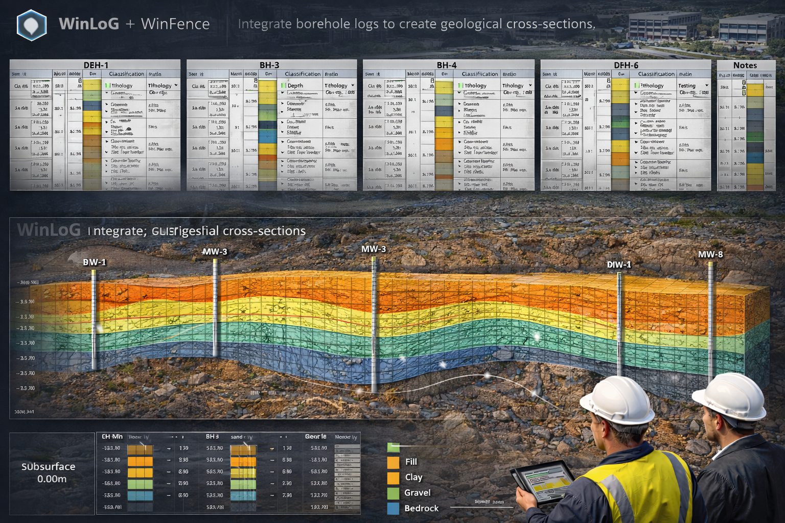
Learn how fence diagrams are used to visualize subsurface geology from borehole data. This guide explains geological cross-sections (1)
Learn how Phase II ESA reports are structured (1)
legacy data digitization (1)
legacy maps (1)
legacy seismic data conversion (1)
Legacy Software (1)
legacy software transition (1)
Legacy Systems (2)
legacy well log conversion (1)
legal defensibility (1)
legal disputes (1)
legal risk management (1)
Lenses (1)
license activation (1)
license analytics (1)
license compliance (1)
License Management (1)
license manager (6)
license migration (1)
License Registration (1)
license server monitoring (1)
license server setup (1)
license transfer (1)
license usage tracking (1)
Limited User (1)
LIMS (1)
Liner System Analysis (1)
LIS (1)
Lithologic Library (1)
lithological correlation (11)
Lithology (3)
lithology data (1)
lithology data import (1)
lithology editing (1)
lithology logging (5)
lithology logging software (1)
lithology logs (2)
Lithology Macros (1)
lithology patterns (1)
lithology templates (1)
local knowledge (1)
Log ASCII Standard (1)
log curve digitization (2)
logging automation (1)
logging errors (1)
logging software (1)
logging software for environmental consultants (1)
logging standards (2)
logging tools (1)
logging workflow (1)
logging workflow optimization (1)
logo (1)
LogPlot (2)
LogPlot alternative (1)
Lookup Lists (1)
low-flow sampling protocol (1)
machine learning engineering (1)
machine learning geology (2)
machine learning in environmental engineering (1)
manual curve tracing (1)
map digitization (4)
map digitization workflow (1)
mapping software (1)
maps (1)
matrix diffusion (3)
MECP guidelines (1)
MECP Ontario (1)
metadata management (1)
Michael Fraser founder (1)
Microsoft Access database (1)
MIGRATE (4)
MIGRATE 10 (1)
Migrate Module (1)
MIGRATE software (1)
MIGRATEv10 (19)
migration workflow (1)
mineral exploration (2)
mineral exploration data (1)
mineral exploration GIS (1)
mineral resource estimation (1)
mining data management (1)
mining geology (1)
mining geology software (1)
mining QA QC (1)
Mining Software (7)
mobile borehole logging app (1)
mobile engineering tools (1)
mobile environmental data collection (1)
mobile field app (1)
mobile geotechnical logging (1)
Mobile Logging (1)
Model Accuracy (1)
Model Calibration (1)
Model Validation (2)
Modeling Best Practices (1)
Modeling Errors (1)
Modeling Software (1)
module registration (1)
Moisture Density Curve. (1)
monitoring (1)
monitoring well casing (1)
monitoring well construction (1)
monitoring well construction materials (1)
monitoring well design (1)
monitoring well logs (4)
monitoring well purging (1)
monitoring wells (5)
Monte Carlo (1)
Monte Carlo simulation (1)
Mother Earth Greek goddess (1)
mud logging (1)
multi user collaboration (1)
Multiphase Diffusion (1)
Multiple Landfills (1)
municipal records (1)
Munsell color (1)
Munsell color matching (1)
N-value (1)
neighbor interviews (1)
network configuration (1)
Network License (5)
network license monitor (1)
network license transfer (1)
network licensing (5)
network login problems (1)
Network Monitor (1)
network registration (1)
Network Setup (1)
network troubleshooting (1)
Network Usage (1)
neutron porosity (1)
new computer setup (1)
Nonlinear Transport (1)
nuclear waste (1)
Numerical Integration (2)
numerical modeling (7)
O Reg 153/04 (2)
OCR geoscience (1)
oil and gas (2)
oil and gas exploration (2)
on premise security (1)
Ontario ESA (1)
Ontario One Call (1)
Ontario Regulation 153/04 (3)
Ontario Workplace Safety (1)
or further investigation. (1)
orehole qa qc (1)
Organic Contaminants (1)
OSHA HAZWOPER (1)
Passive Sink (4)
PDF export workflow (1)
perchlorate compliance (1)
performance tuning (1)
permeability testing (1)
Perpetual (1)
petroleum data (1)
petroleum data digitization (1)
petroleum exploration data (1)
Petroleum exploration software (1)
petroleum products environmental assessment (1)
PFAS (1)
PFAS compliance (1)
Phase 1 ESA (5)
Phase 2 Environmental Site Assessment (4)
Phase Change Modeling (1)
phase I environmental site assessment (7)
Phase I ESA (12)
Phase I ESA Automation (1)
Phase I ESA drainage patterns (1)
Phase I ESA financing (1)
Phase I ESA Follow-Up (1)
Phase I ESA hazardous substances (1)
Phase I ESA photographs (1)
Phase I ESA process (4)
Phase I ESA purpose (1)
Phase I ESA report (1)
Phase I ESA visual inspection (1)
Phase I ESA workflow (1)
phase II environmental site assessment (2)
Phase II ESA (20)
Phenol (1)
Photoionization Detector (1)
physical well logs (1)
pilot testing (1)
Plasticity Index (1)
plume analysis (2)
plume behavior (1)
Plume Interaction (1)
plume migration (4)
plume modeling (3)
plume simulation (1)
pocket penetrometer (1)
POLLUTE (5)
POLLUTE 10 (1)
Pollute and Migrate (1)
Pollute and Migrate 10 (1)
Pollute Module (1)
pollute software (2)
POLLUTE software research (1)
POLLUTEv10 (25)
POLLUTEv8 (13)
Pollution Modeling (1)
pollution transport simulation (12)
Port 3000 (2)
port 3002 (1)
Potassium Transport (1)
Potholing (1)
Power User (1)
PPE Environmental (1)
predictive analytics (1)
predictive models (1)
predictive simulation (1)
predictive subsurface modeling (1)
print cross section (1)
Private Utility Locates (1)
probabilistic modeling (2)
Proctor Test (1)
productivity improvement (1)
professional liability (1)
Project Analytics (1)
project certainty (1)
Project Dashboard (1)
project data management (1)
Project Documents (1)
project management (2)
Project Management Dashboard (1)
project migration (1)
project overruns (1)
project ROI (1)
Project Templates (1)
Project Views (2)
project views mapping (1)
property contamination (1)
property environmental assessment (2)
property history (1)
property records review (1)
property tax records (1)
protective well cover (1)
PT (1)
public records search (1)
purge volume calculation (1)
PVC vs stainless steel well casing (1)
PVC well casing (1)
QA QC (7)
QA QC Environmental (1)
QA QC Plans (1)
QA QC workflow (1)
QA QC workflows (1)
QAQC (1)
Quality Assurance (1)
Quality Control (2)
Questionnaire Merging (1)
QuickFence (1)
Quicklog (2)
radioactive contaminants (1)
Radioactive Decay (1)
random sampling analysis (1)
RCRA database (1)
RCRA Landfill (1)
reactive transport (1)
real estate due diligence (2)
real estate due diligence environmental (1)
real estate risk assessment (1)
real-time mapping (1)
real-time monitoring (1)
REC evidence ESA (1)
REC identification ESA (1)
recognized environmental conditions (8)
record retention (1)
recovery and rqd (1)
RECs (5)
reduce borehole logging time (1)
reduce MTTR (1)
regulatory compliance (6)
regulatory environmental reporting (1)
regulatory submissions (1)
regulatory viewer. (1)
remediation (1)
Remediation Planning (1)
Remediation Software (1)
Remediation Strategies (1)
remediation timelines (1)
Remote Access (1)
remote access software (1)
remote collaboration (1)
remote desktop (1)
renewable energy (1)
report automation (2)
report generation (1)
Report Templates. (1)
reporting automation (3)
Research paper viewer (1)
reservoir characterization logs (1)
reservoir mapping (1)
resistivity (1)
resistivity log (1)
resistivity log digitization (1)
resistivity log extraction (1)
resource allocation (1)
resource estimation (2)
resource management (1)
resource modelling (1)
retardation (1)
Retardation Factor (1)
revision history (1)
riser pipe materials. (1)
risk analysis (1)
risk assessment (2)
Risk Management (2)
Road Occupancy Permit (1)
rock core logging (1)
rock logging (1)
rock logging software (1)
rock mechanics (1)
rock quality (1)
RockWare (1)
RockWare LogPlot (1)
RockWorks (1)
ROI (4)
ROI calculation (1)
role based access control (3)
role based permissions (1)
RQD (2)
rule engine (1)
safety protocols (1)
sample data (1)
Sample Descriptors (1)
Sample Handling (1)
sample integrity (1)
Sample Labeling (1)
sample planning (1)
sample preservation (1)
sampling data (1)
Sampling Events (1)
sampling frequency (1)
sampling guide (1)
sampling plan (1)
Sanborn maps (1)
SAP guide (1)
scanning well logs (1)
schema validation (1)
Scout tickets (1)
scouting initiatives (1)
SCR (1)
secure data management (2)
secure data sharing (1)
Secure Databases (1)
secure engineering software (1)
SEG-Y (1)
Segments (1)
seismic analysis (1)
seismic archive digitization (2)
seismic archive restoration (1)
seismic data (2)
seismic data calibration (1)
seismic data digitization (2)
seismic data enhancement (1)
seismic data format (1)
seismic data management (1)
seismic data modernization (2)
seismic data preservation (1)
seismic digitization (2)
seismic digitization workflow (1)
seismic digitization workflows (1)
seismic image processing (1)
seismic interpretation software (1)
seismic interpretation workflows (2)
seismic modeling (1)
seismic noise reduction (1)
seismic preprocessing (1)
seismic processing techniques (1)
seismic reflection data (1)
seismic reflection surveys (1)
Seismic Section Digitization (5)
seismic trace extraction (1)
Sensitivity Analysis (3)
serial numbers (1)
server IP (1)
server migration guide (1)
server setup (1)
server upgrade (1)
Sieve Analysis (1)
sieve analysis software (1)
simulation analysis (1)
Simulation Software (1)
single user license (1)
single-user license (1)
site assessment (9)
Site Assessment Canada (2)
site assessment Ontario (1)
Site Assessment Software (1)
site assessments (1)
site contamination (4)
site contamination assessment (5)
site history (2)
Site Investigation (5)
site investigation costs (1)
site investigation data (9)
Site Investigation Permits (1)
Site Investigation Safety (2)
site investigation software (2)
site investigation tools (1)
site monitoring wells (1)
site planning (1)
site reconnaissance (2)
site selection (1)
Site Visualization. (1)
Site-Specific HASP (1)
SMS Alerts (1)
snapping (1)
Snapping Tool (2)
Snapping Tools (1)
software activation (1)
software adoption (1)
software best practices (1)
software buyer guide (1)
software buying mistakes (1)
software costs (1)
software design (1)
software evaluation (3)
software hosting (1)
software implementation (3)
software installation (1)
Software Installation Guide (1)
software investment (1)
software license management (2)
software licensing (1)
software migration (1)
software modules (1)
software pilot project (1)
software registration (3)
software release announcement (1)
software ROI (2)
software rollout (1)
software selection (1)
software selection guide (1)
software setup (1)
software update (1)
software upgrade (1)
Soil Analysis (1)
soil and groundwater investigation (1)
soil behavior (1)
soil boring log software (1)
soil boring logs Excel (1)
soil classification (9)
Soil Compaction (1)
Soil Contamination (4)
soil core sampling (1)
Soil Diffusion (1)
Soil Lab Software (1)
soil logging (1)
soil logging software (2)
soil logging tools (1)
soil mechanics (1)
soil modeling (1)
soil moisture measurement (1)
soil sample collection (1)
soil sampling (11)
soil sampling environmental site assessment (1)
soil testing (8)
soil testing data (1)
Soil Testing Software (3)
Solids (1)
Solute transport software (1)
sonic log digitization (2)
Sorption (6)
Sorption Modeling (1)
Spatial Analysis (1)
spatial data (1)
spatial data import (1)
spatial geology data (1)
spatial interpolation (1)
splicing core images (1)
spreadsheet cleanup (1)
spreadsheets (1)
SPT (3)
SPT Techniques (1)
SPT testing (1)
spt validation (1)
Standalone (1)
standalone software (1)
Standard Penetration Test (2)
standardized data (1)
standardized reporting (1)
static water level measurement (1)
statistical outlier detection (1)
steel well casing (1)
Step Function Approximation (1)
stick-up well protector (1)
stochastic simulation (1)
storage (1)
storage tanks ESA (1)
strata (1)
strata correlation (2)
Strata Definitions (1)
Strata Styles (1)
Strata Types (1)
StrataExplorer (1)
StrataExplorer 3 (1)
StrataExplorer migration (1)
Stratigraphic Boundaries (1)
stratigraphic correlation (10)
stratigraphic monitoring (1)
stratigraphic visualization (1)
stratigraphy data import (1)
stratigraphy visualization (1)
stressed vegetation contamination (1)
strip log software (1)
structural geology maps (1)
structural stability (1)
structured data (2)
Subscription (1)
subsurface analysis (1)
subsurface data (29)
subsurface data digitization (3)
subsurface data display (1)
subsurface data integration (1)
subsurface data management (39)
subsurface data quality control (1)
Subsurface Data Sync (1)
subsurface data visualization (1)
Subsurface Database (1)
subsurface databases (1)
subsurface environmental investigation (1)
subsurface imaging data (1)
subsurface investigation (5)
subsurface investigation. (1)
subsurface investigations (2)
subsurface migration tool. (1)
subsurface modeling (16)
subsurface modeling data (1)
subsurface modeling GIS (1)
subsurface modeling oil and gas (1)
subsurface modeling software (1)
subsurface seismic imaging (1)
subsurface structural interpretation (1)
subsurface structures (2)
subsurface transport (3)
subsurface uncertainty (1)
subsurface visualization (4)
subsurface visualization export (1)
surface water environmental assessment (1)
sustainability (1)
sustainability in construction (1)
sustainability in engineering (1)
sustainability reporting (1)
sustainability software (1)
sustainable energy (2)
sustainable heat sources (1)
sustainable practices (1)
system administration (1)
system implementation (1)
system upgrade (1)
Tags (comma separated): Phase II ESA (1)
Talbot Method (2)
Task Management (2)
TCO (2)
TCP port (1)
TCP port testing (1)
TCR (1)
TDAST (2)
technical support (2)
technology adoption (1)
technology in geotechnics (1)
template (1)
Template Designer (1)
template import (1)
The Water Project (1)
Time Varying Source (1)
Time-Dependent Sources (1)
Time-Varying Liner Failure (1)
timestamp management (1)
Toluene Transport (1)
Torvane calibration (1)
total cost of ownership (3)
Transport Modeling (2)
transportation infrastructure (1)
transportation projects (1)
triaxial test (1)
Tunnel Foundation Safety (1)
Tunneling Design (1)
UAV environmental site assessment (1)
uncertainty quantification (1)
Unconformities (1)
Underground Construction (1)
underground storage tank database (1)
Underground Utilities (1)
unlock codes (1)
upgrade geotechnical software (1)
upgrade workflow (1)
upward flow (1)
urban drilling (2)
usage analytics (1)
USCS automation (1)
USCS standards (1)
user activity tracking (1)
User Management (1)
user migration (1)
Utility Clearance (1)
utility clearances (1)
Utility Locates (1)
utomated environmental reporting (1)
validation evidence (1)
validation rules (1)
variable properties (2)
vectorizing geological maps (1)
version control (4)
vintage seismic data (1)
vintage well log digitization (1)
virtual desktop infrastructure (1)
VOC measurement (1)
VOC migration (2)
VOC sampling (1)
volatile organic compounds (1)
VPN (1)
Waste Disposal Regulations (1)
waste management (2)
water crisis Africa (1)
water level monitoring (1)
water management (1)
water protection (1)
Web Map Services (1)
well annulus calculation (1)
well casing (1)
Well Construction (2)
well construction diagrams (1)
well data Excel import (1)
well diagram WinLoG (1)
well installation (2)
well location data import (1)
well log (2)
well log comparison (1)
well log data processing (2)
well log digitization (9)
well log interpretation (1)
well log interpretation data (1)
well log quality control (1)
well log report issues (1)
well log software (5)
well log templates (1)
well log validation (1)
well logging (5)
well logging software (1)
well logs (3)
well records (1)
well screen slot size selection (1)
well sealing (1)
well stabilization parameters (1)
well volume purging (1)
wellbore (1)
Windows 11 (1)
Windows app (1)
Windows geotechnical app (1)
Windows Software (1)
Windows XP (1)
winfence (11)
WinFence cross-sections (1)
WinFence export PDF (1)
WinFence output settings (1)
WinFence tutorial (1)
WinLoG (42)
WinLoG 4 (1)
WinLoG 6 (1)
WinLoG borehole software (1)
WinLoG cloud (1)
WinLoG data import tutorial (1)
WinLoG demo (1)
WinLoG Excel import (1)
WinLoG features (1)
WinLoG Field Assistant (9)
WinLoG fix guide (1)
WinLoG header issue (1)
WinLoG integration (1)
winlog lithology (1)
WinLoG mining (1)
WinLoG RT (2)
WinLoG Software (5)
WinLoG templates (3)
WinLoG troubleshooting (1)
WinLoG tutorial (4)
WinLoG upgrade (2)
WinLoG version 6 (1)
WinLoG vs LogPlot (1)
WinLoG well construction (1)
WinSieve (1)
WinSieve upgrade (1)
workflow approval (1)
workflow automation (3)
workflow efficiency (1)
workflow optimization (3)
workflow records (1)
XML data exchange (1)
XML geotechnical data (2)
z score validation (1)
zoning records (1)