
Did you know that nearly 60% of infrastructure project failures stem from poor geological data management? As the construction industry increasingly adopts innovative technologies, the integration of 3D models with traditional boring logs is transforming the landscape of project management. This blog post will explore the importance of blending 2D boring logs with 3D modeling to enhance the efficiency and accuracy of complex infrastructure projects. We will cover the benefits of this integration and the steps you can take to implement it in your projects, thereby reducing risks and improving outcomes.
Infrastructure projects are complex endeavors that often involve various geological challenges. In traditional practices, engineers rely heavily on 2D boring logs to assess soil conditions, rock formations, and groundwater levels. However, as projects grow in complexity, so does the need for more detailed, accurate, and integrative approaches to geological data management.
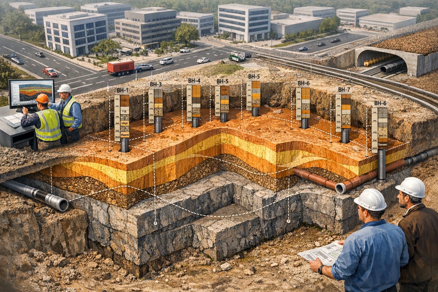
The Shortcomings of Traditional 2D Boring Logs
Boring logs provide critical information about subsurface conditions, but they come with inherent limitations. While they offer essential data points, they are essentially snapshots of specific locations and do not convey the full three-dimensional relationships between geological elements. This usually leads to:
- Limited Spatial Understanding: Engineers make decisions based on data from points that may be far apart, leading to gaps in understanding.
- Inefficient Resource Allocation: Misunderstanding of subsurface conditions can impact project planning, leading to delays and cost overruns.
- Increased Risk: Poor geological data can result in unexpected issues, including structural failures or hazardous conditions during construction.
Why 3D Models Matter
Integrating 2D boring logs with 3D models revolutionizes how infrastructure projects are managed. Here are key reasons why using 3D models is critical:
- Enhanced Visualization: 3D models provide a comprehensive view of sub-surface conditions, allowing teams to visualize the relationships between various geological features.
- Improved Decision-Making: Enhanced visual interpretation of data helps engineers make informed decisions, mitigating risks and cutting costs.
- Collaboration and Communication: 3D models serve as interactive communication tools among stakeholders, making the information accessible and easy to understand.
The Integration Process
Integrating 2D boring logs into 3D models isn’t merely a technical process; it represents a shift towards a more holistic approach to data management in the construction industry. Here’s how to do it:
Step 1: Data Collection
Begin by gathering all relevant geological data, including existing boring logs, geological maps, and survey data. This foundational layer is crucial for accurate model building.
Step 2: Data Conversion
Utilize software that can convert 2D boring log data into a 3D format. Various programs can read borehole data and produce 3D geological models.
Step 3: Model Building
Using specialized software, build a comprehensive 3D model by layering the data collected in Step 1. This phase may also include integrating environmental factors and construction parameters.
Step 4: Validation
Once the model is created, conduct validation checks against existing data to ensure accuracy. Engage with geologists and engineers to confirm the model’s fidelity.
Step 5: Utilize the Model in Project Planning
Incorporate the 3D model into your planning process, using it as a reference to inform design choices, safety measures, and construction timelines.
Benefits of Using Integrated Models
The benefits of integrating boring logs with 3D models in infrastructure projects are numerous and impactful:
- Reduced Costs: While there may be an upfront investment in technology, the long-term savings stem from minimizing unnecessary diggings and reducing the risk of geological disasters.
- Time Efficiency: With enhanced visualization and decision-making processes, project timelines can be accelerated, leading to quicker completions.
- Risk Mitigation: By better understanding the geology, teams can plan for contingencies more effectively, resulting in fewer interruptions and setbacks.
Real-World Applications
Several organizations have successfully implemented integrated 3D models in their projects. Here are a couple of examples:
- Case Study: Urban Infrastructure Project: In a recent urban development project, engineers used integrated models to enhance the foundation design for high-rises. By better visualizing soil and rock conditions around site-specific factors, they were able to modify designs that saved construction costs significantly.
- Case Study: Highway Expansion: During a highway expansion project, integrating subsurface models led to identifying unsuitable soils that could have caused future structural issues. Early intervention through the 3D model prevented costly delays.
Challenges and Considerations
Despite the clear benefits, integrating 2D boring logs into 3D models does come with challenges:
- Data Compatibility: All systems used must be compatible, necessitating investments in specific software.
- Training: Teams must be trained to use the new tools and interpret the models correctly.
- Initial Costs: Several upfront costs may deter organizations, although they should be weighed against the long-term benefits.
The Future of Geological Data Integration
As technological advancements continue, integrating 2D borehole data with 3D models will likely become the industry standard for infrastructure projects. Embracing these technologies will not only create more resilient structures but will also pave the way for smarter construction practices in an ever-evolving landscape.
Final Thoughts
By integrating boring logs with 3D modeling, you gain a competitive edge in managing complex infrastructure projects. With enhanced visualization and better data management, you can minimize risks and maximize efficiency.
So now what? If you want to stay ahead in the construction industry, embrace 3D technology and start integrating it into your projects today.
Remember, integrating boring logs into 3D models is not just a trend; it’s the future of intelligent infrastructure planning!
Learn more about our Solutions
- GaeaSynergy Platform for Geoscientific Analysis
- WinLoG Borehole and Well Log Data Management
- WinFence Cross-section and Fence Diagram Visualization
Related Articles
- GaeaSynergy: Integrated Geological, Geotechnical, and Environmental Data Management Platform
- The Complete Guide to Borehole Data Solutions
- The Complete Guide to Geotechnical Data Management
- The Complete Guide to Environmental Data Management
- Geological Cross-Sections from Borehole Data: A Complete Engineering Guide
- Integrated Geological and Geotechnical Data Platforms
- Why Engineering Firms Need Integrated Subsurface Data Platforms
- Managing Geological, Geotechnical, and Environmental Data in One Platform
- Digital Platforms for Subsurface Investigation Data
- Connecting Borehole Databases with Geological Modeling Software
- GIS Integration in Geological and Geotechnical Data Platforms
- Data Governance in Geological and Engineering Platforms
- The Future of Integrated Subsurface Data Platforms
- How Artificial Intelligence Is Transforming Geotechnical & Environmental Engineering
- Protecting Our Water: Monitoring Contaminant Plumes Through Real-Time Stratigraphic Mapping
- Strategic Data Management in GaeaSynergy
- Seamless Data Flow: Mastering Import and Export in GaeaSynergy
- Mapping the Site: GIS and Spatial Data Management in GaeaSynergy
- Comprehensive Site Intelligence: Integrating Subsurface Data and Infrastructure in GaeaSynergy 3D
- Visualizing the Invisible: 3D Above and Below Ground Structures in GaeaSynergy
- Mastering Subsurface Visualization: Contouring and Gridding in GaeaSynergy
- From Data to Discovery: Visualizing the Subsurface with GaeaSynergy
- GAEA Technologies Software in the Oil & Gas Industry
- Beyond the Surface: How GAEA Technologies Software Powers Modern Mining
- Winning More Bids: Using High-Resolution Subsurface Visualization to Demonstrate Project Certainty
- Selecting the Right Gridding Algorithm for Your Contour Map
- The Science of Doubt: How to Quantify and Visualize Subsurface Uncertainty in Geological Models
- Geoscientific Analysis: Key Uses and Benefits