
Did you know that millions of people worldwide rely on clean water for their daily lives? With increasing threats to our water sources from contamination, monitoring and protecting our water resources is more crucial than ever. In this blog post, we will explore how real-time stratigraphic mapping can help us track and manage contaminant plumes, ensuring a safer future for our water supply. We’ll discuss the significance of this technology, the methods used in monitoring, and the positive impacts of effective water protection strategies. Moreover, we will highlight how WinFence software can provide visualizations of contaminant plumes in cross-section, making these complex issues easier to understand. Get ready to dive deep into the innovative world of water resource management!
Understanding Contaminant Plumes
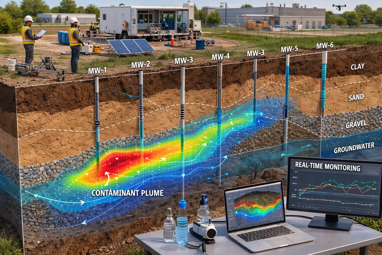
Contaminant plumes refer to the areas of groundwater or soil that are polluted, often as a result of human activity such as industrial spills, agricultural runoff, or improper waste disposal. These plumes can spread and create significant risk to both public health and the environment. The dynamics of these plumes vary widely depending on the type of contaminants involved, the geology of the area, and the hydrology of the region.
The Need for Effective Monitoring
With the threat of contaminants growing, the need for effective monitoring techniques becomes imminent. Traditional methods often provide insufficient data, making it challenging to address the complexities of groundwater contamination. However, advancements in technology have led to the development of real-time stratigraphic mapping—an innovative solution enabling better tracking and management of contaminant plumes.
What is Real-Time Stratigraphic Mapping?
Real-time stratigraphic mapping is a process where geological and stratigraphic data is collected and analyzed in real time. This technique allows for immediate insights into the subsurface conditions, including the location, extent, and concentration of contaminant plumes. By integrating advanced technologies like Geographic Information Systems (GIS), remote sensing, and drilling technologies, water resource managers can generate detailed maps that help visualize and monitor contaminants as they move through the ground.
Furthermore, WinFence excels in providing detailed cross-section diagrams that illustrate contaminant plumes. This visualization makes it easier for stakeholders to understand the extent and impact of the contamination, facilitating better decision-making.
The Importance of Timely Data
Real-time data acquisition is essential for effective decision-making. It allows environmental agencies, engineers, and community leaders to respond quickly to contamination events more accurately and efficiently. When they receive timely data, stakeholders can implement appropriate remediation strategies, minimizing the adverse effects on public health and the environment.
Benefits of Real-Time Stratigraphic Mapping
- Enhanced Visualization: Mapping helps visualize the extent and movement of contaminant plumes. WinFence’s cross-section diagrams make understanding these dynamics simple and accessible, allowing for more effective planning of remediation efforts.
- Immediate Responses: The ability to capture and analyze data in real-time ensures that response teams can act quickly to mitigate contamination impacts.
- Cost-Effectiveness: By utilizing advanced mapping technologies, water resource managers can save costs associated with more expensive traditional monitoring methods.
- Community Safety: Protecting public health by ensuring that contaminated areas are managed effectively reduces the risk to populations dependent on local water resources.
Implementing Real-Time Stratigraphic Mapping
The implementation of real-time stratigraphic mapping involves several steps:
- Site Assessment: Conducting preliminary investigations to understand the local geology and potential contamination sources.
- Data Collection: Employing advanced drilling techniques and sensors to collect sediment and groundwater samples at various depths.
- Data Integration: Utilizing GIS technology to integrate spatial data with stratigraphic and well data to create accurate maps and cross-sectional views of contaminant plumes using WinFence.
- Continuous Monitoring: Setting up systems for ongoing data collection to track contaminant movement over time.
Challenges and Considerations
While real-time stratigraphic mapping has tremendous potential, there are challenges:
- Technical Expertise: It requires skilled professionals to interpret the intricate data generated through advanced techniques.
- Costs and Resources: Initial setup costs for technology and training can be significant, though the long-term savings are substantial.
- Regulatory Framework: A regulatory environment that facilitates real-time monitoring efforts across regions is needed for successful implementations.
The Future of Water Protection
With ongoing advancements in technology and a growing recognition of the importance of our water resources, real-time stratigraphic mapping, particularly using tools like WinFence, is likely to become a cornerstone in environmental protection strategies. As communities around the world face increasing contamination threats, investing in innovative monitoring solutions will be essential to safeguard our water resources.
So, Now What?
Understanding how to effectively monitor and manage contaminant plumes is vital for protecting our water supply. Real-time stratigraphic mapping provides a robust solution for tracking contamination and improving response strategies. By leveraging technology like WinFence, communities can visualize contaminant plumes in cross-section, ensuring safe water resources for current and future generations.
Learn more about WinFence and how we can help you implement effective monitoring strategies in your region:.
Remember, the health of our water resources depends on proactive measures. Together, we can protect precious water supplies and create a sustainable future for all!
Learn more about our Solutions
- GaeaSynergy Platform for Geoscientific Analysis
- WinLoG Borehole and Well Log Data Management
- WinFence Cross-section and Fence Diagram Visualization
Related Articles
- GaeaSynergy: Integrated Geological, Geotechnical, and Environmental Data Management Platform
- The Complete Guide to Borehole Data Solutions
- The Complete Guide to Geotechnical Data Management
- The Complete Guide to Environmental Data Management
- Geological Cross-Sections from Borehole Data: A Complete Engineering Guide
- Integrated Geological and Geotechnical Data Platforms
- Why Engineering Firms Need Integrated Subsurface Data Platforms
- Managing Geological, Geotechnical, and Environmental Data in One Platform
- Digital Platforms for Subsurface Investigation Data
- Connecting Borehole Databases with Geological Modeling Software
- GIS Integration in Geological and Geotechnical Data Platforms
- Data Governance in Geological and Engineering Platforms
- The Future of Integrated Subsurface Data Platforms
- How Artificial Intelligence Is Transforming Geotechnical & Environmental Engineering
- Beyond 2D: Integrating Boring Logs with 3D Models for Complex Infrastructure Projects
- Strategic Data Management in GaeaSynergy
- Seamless Data Flow: Mastering Import and Export in GaeaSynergy
- Mapping the Site: GIS and Spatial Data Management in GaeaSynergy
- Comprehensive Site Intelligence: Integrating Subsurface Data and Infrastructure in GaeaSynergy 3D
- Visualizing the Invisible: 3D Above and Below Ground Structures in GaeaSynergy
- Mastering Subsurface Visualization: Contouring and Gridding in GaeaSynergy
- From Data to Discovery: Visualizing the Subsurface with GaeaSynergy
- GAEA Technologies Software in the Oil & Gas Industry
- Beyond the Surface: How GAEA Technologies Software Powers Modern Mining
- Winning More Bids: Using High-Resolution Subsurface Visualization to Demonstrate Project Certainty
- Selecting the Right Gridding Algorithm for Your Contour Map
- The Science of Doubt: How to Quantify and Visualize Subsurface Uncertainty in Geological Models
- Geoscientific Analysis: Key Uses and Benefits