
Did you know that 70% of project bids are lost due to lack of visualization in proposals? In today’s competitive market, demonstrating project certainty can be the difference between winning and losing a bid. Understanding how to effectively utilize high-resolution subsurface visualization is crucial for any business looking to win more projects. In this guide, we’ll explore the power of advanced visualization techniques in the bidding process, how to incorporate these methods into your proposals, and the benefits they can bring to your project outcomes.
Understanding the Importance of Subsurface Visualization
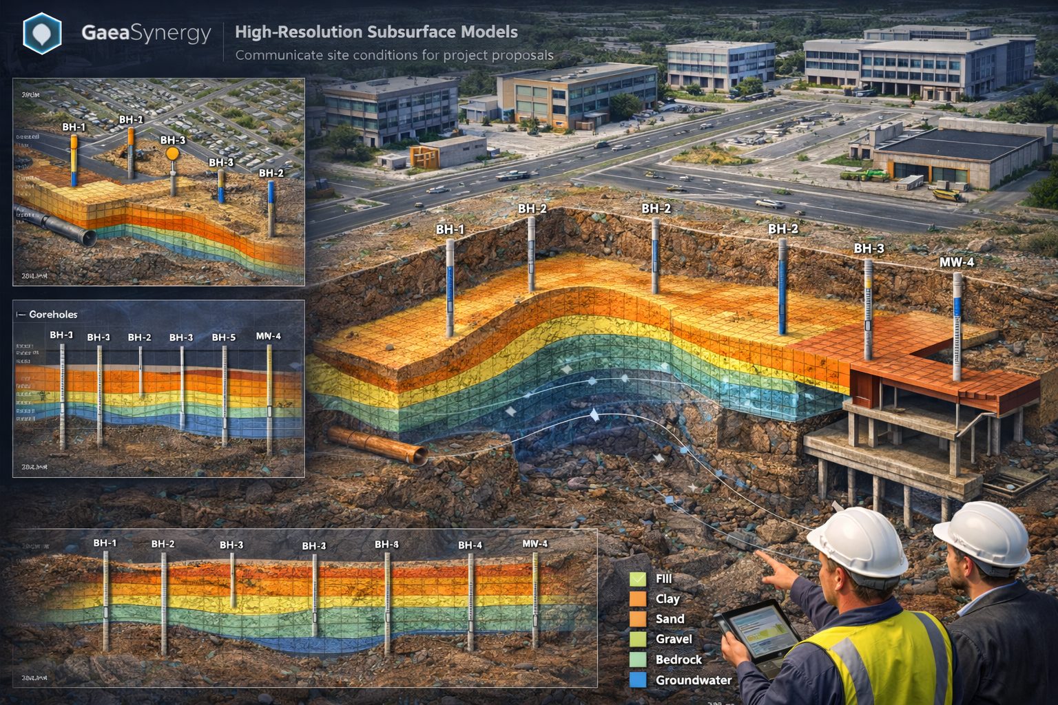
In the construction and engineering industries, outdated or generic visualizations can hinder the bidding process. Project certainty is paramount, and ensuring your potential clients can visualize the end result aids in building trust and clarity. High-resolution subsurface visualization translates complex geological and environmental data into detailed graphics that tell a cohesive story about what lies beneath the surface.
The Role of Technology in Visualization
Technological advancements have led to the development of sophisticated software that can produce these high-resolution images. These tools enable professionals to display a variety of subsurface scenarios, including soil types, moisture levels, and the potential impact of unexpected issues. The ability to anticipate challenges before they arise can dramatically decrease the likelihood of unexpected costs and delays in project execution.
Key Benefits of High-Resolution Subsurface Visualization
- Enhanced Decision Making: Providing a visual context helps stakeholders make informed choices during the bidding process.
- Increased Client Confidence: Clients feel more secure when they have a clear understanding of the project parameters and risks.
- Differentiation from Competitors: Companies leveraging high-quality visuals set themselves apart in bids, showcasing advanced capabilities.
- Streamlined Communication: Visual tools facilitate easier discussions regarding project expectations, timelines, and unforeseen challenges.
Creating Compelling Visualizations
1. Collecting Data
The first step in creating impactful visualizations is compiling all necessary data. This includes geological surveys, environmental assessments, and any previous project notes relevant to the area in which the new project will take place. Make sure the data is up-to-date and comprehensive to allow for the most accurate representation possible.
2. Utilizing the Right Software
Leverage the latest subsurface visualization tools available in the market. These programs are designed not only to create stunning visuals but to integrate seamlessly with other engineering software, ensuring all project data is consolidated in one place.
3. Focusing on Clarity and Detail
When creating visuals, prioritize clarity. Ensure that your images are not overcrowded with information, making it difficult for viewers to focus on key elements. Additionally, using detailed graphics can make all the difference in showcasing the subsurface conditions, allowing stakeholders to quickly absorb the data presented.
Integrating Visualization into Your Bidding Process
1. Training Your Team
For effective communication of project certainty, it’s crucial that your team is proficient in utilizing visualization tools. Investing in training will not only improve their skills but also enhance the quality of proposals you submit.
2. Combining Visuals with Compelling Narratives
Powerful images should always be accompanied by a clear narrative. Describe in detail what the viewer is seeing and why it matters. Context matters: what do specific soil characteristics mean for project execution? What should clients be concerned about?
3. Tailoring Proposals to Fit Client Needs
Every project and client will have different needs. Customize each bid by analyzing the target audience and addressing their specific concerns. High-resolution visuals can be tailored to highlight elements of particular interest to them.
Future Trends in Subsurface Visualization
As technology evolves, the potential for subsurface visualization is bound to expand. With artificial intelligence and machine learning systems increasingly integrated into visualization software, predictions about subsurface characteristics and risks will become even more precise. Staying ahead of these trends will ensure your company remains competitive in the bidding landscape.
Wrapping Up: Making Change Happen
Winning more bids in a competitive landscape begins with embracing change. Utilizing high-resolution subsurface visualization provides project certainty, instills client confidence, and reveals a commitment to quality that bidders appreciate. By honing your approach to visuals and narratives, you can truly set your company apart.
So Now What?
Now that you understand the power of high-resolution subsurface visualization, it’s time to take action. Start integrating these techniques into your bidding strategies today, and experience the difference for yourself.
Learn more about our Solutions
- GaeaSynergy Platform for Geoscientific Analysis
- Borehole and Well Log Data Management
- Cross Sections and Sub-surface Visualization
- Geotechnical Data Management System
- Environmental Data Management System
Related Articles
- GaeaSynergy: Integrated Geological, Geotechnical, and Environmental Data Management Platform
- Subsurface Visualization: Turning Borehole Data into Clear Geological Insight
- The Complete Guide to Borehole Data Solutions
- The Complete Guide to Geotechnical Data Management
- The Complete Guide to Environmental Data Management
- Geological Cross-Sections from Borehole Data: A Complete Engineering Guide
- Integrated Geological and Geotechnical Data Platforms
- Why Engineering Firms Need Integrated Subsurface Data Platforms
- Managing Geological, Geotechnical, and Environmental Data in One Platform
- Digital Platforms for Subsurface Investigation Data
- Connecting Borehole Databases with Geological Modeling Software
- GIS Integration in Geological and Geotechnical Data Platforms
- Data Governance in Geological and Engineering Platforms
- The Future of Integrated Subsurface Data Platforms
- How Artificial Intelligence Is Transforming Geotechnical & Environmental Engineering
- Beyond 2D: Integrating Boring Logs with 3D Models for Complex Infrastructure Projects
- Protecting Our Water: Monitoring Contaminant Plumes Through Real-Time Stratigraphic Mapping
- Strategic Data Management in GaeaSynergy
- Seamless Data Flow: Mastering Import and Export in GaeaSynergy
- Mapping the Site: GIS and Spatial Data Management in GaeaSynergy
- Comprehensive Site Intelligence: Integrating Subsurface Data and Infrastructure in GaeaSynergy 3D
- Visualizing the Invisible: 3D Above and Below Ground Structures in GaeaSynergy
- Mastering Subsurface Visualization: Contouring and Gridding in GaeaSynergy
- From Data to Discovery: Visualizing the Subsurface with GaeaSynergy
- GAEA Technologies Software in the Oil & Gas Industry
- Beyond the Surface: How GAEA Technologies Software Powers Modern Mining
- Selecting the Right Gridding Algorithm for Your Contour Map
- The Science of Doubt: How to Quantify and Visualize Subsurface Uncertainty in Geological Models
- Geoscientific Analysis: Key Uses and Benefits