
A Comprehensive Guide to Centralizing Subsurface Data for Engineering and Environmental Projects
Modern geotechnical and environmental projects generate enormous amounts of subsurface information. Borehole logs, laboratory test results, monitoring data, geological models, GIS layers, and engineering interpretations all contribute to understanding the ground conditions beneath a site. Traditionally, this information has been stored across spreadsheets, standalone databases, CAD files, and GIS software, often maintained by different teams.
This fragmented approach creates challenges for data integrity, collaboration, and long-term project management. Integrated geological and geotechnical data platforms solve this problem by bringing all subsurface data into a unified system where engineers, geologists, and project managers can manage, analyze, and visualize information efficiently.
This article explores what integrated geological and geotechnical data platforms are, why they are increasingly important, the key features they provide, and how organizations benefit from implementing them.
The Challenge of Managing Subsurface Data
Subsurface investigations produce data from multiple sources over the lifecycle of a project. These sources include:
- Borehole drilling logs
- Cone penetration testing (CPT) data
- Laboratory test results
- Groundwater monitoring data
- Geological interpretations
- GIS mapping layers
- Engineering reports and cross-sections
Without an integrated system, organizations typically rely on disconnected workflows. For example, borehole logs may be stored in spreadsheets, laboratory results in separate databases, cross-sections created in CAD software, and spatial data managed in GIS platforms.
This fragmentation leads to several problems:
Data Duplication
Multiple copies of the same borehole data may exist across different systems, making it difficult to ensure consistency.
Data Errors
Manual data transfer between systems increases the risk of mistakes in coordinates, elevations, lithology codes, or depth intervals.
Limited Collaboration
Different teams may work with different versions of the same dataset, resulting in conflicting interpretations.
Inefficient Workflows
Engineers and geologists spend significant time cleaning, validating, and transferring data instead of analyzing it.
Integrated platforms address these challenges by centralizing all geological and geotechnical data into a single environment.
What Is an Integrated Geological and Geotechnical Data Platform?
An integrated geological and geotechnical data platform is a software environment designed to manage the full lifecycle of subsurface information. It connects data management, visualization, analysis, and reporting within a unified system.
Rather than working with multiple disconnected tools, users interact with a single platform that supports:
- Borehole data management
- Geological interpretation
- GIS mapping
- Laboratory and monitoring data storage
- Cross-section generation
- 3D subsurface visualization
These platforms typically rely on structured relational databases combined with visualization tools and geospatial capabilities.
The goal is to ensure that all subsurface information—from raw field measurements to final engineering interpretations—is stored, validated, and accessible in one centralized location.
Core Components of Integrated Data Platforms
Integrated geological and geotechnical platforms typically consist of several interconnected components that work together to manage subsurface data.
Borehole Data Management
Borehole data is the foundation of most subsurface investigations. Integrated platforms provide structured databases for storing drilling information, including:
- Borehole coordinates and elevation
- Drilling methods and equipment
- Lithological descriptions
- Sampling intervals
- Standard penetration test (SPT) results
- Core recovery and rock quality designation (RQD)
These systems enforce standardized data formats and validation rules to ensure consistency across projects.
By maintaining borehole data in a centralized database, engineers can easily retrieve and analyze information across multiple sites and investigations.
Geological and Geotechnical Data Integration
Subsurface investigations involve more than just drilling logs. Integrated platforms combine multiple datasets into a unified framework, including:
- Geological interpretations
- Laboratory test results
- Field test data
- Monitoring measurements
- Engineering properties
By linking these datasets to boreholes and spatial coordinates, the platform enables comprehensive analysis of subsurface conditions.
For example, laboratory test results can be directly associated with the sample depth and lithological unit from which the specimen was collected.
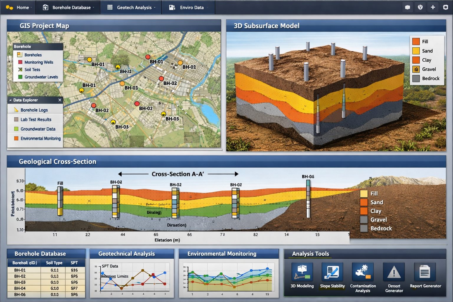
GIS Mapping and Spatial Analysis
Geotechnical investigations are inherently spatial. Integrated platforms incorporate GIS capabilities to manage and visualize subsurface data geographically.
Key GIS functions include:
- Mapping borehole locations
- Overlaying geological maps
- Displaying infrastructure and site boundaries
- Integrating topographic and aerial imagery
GIS integration allows users to understand how subsurface conditions vary across a site or region.
Spatial analysis also helps identify patterns such as groundwater flow directions, stratigraphic continuity, or zones of weak soils.
Gridding and Contouring
Many geological and geotechnical interpretations rely on interpolating data between boreholes.
Integrated platforms often include gridding and contouring tools that allow users to generate:
- Surface elevation models
- Bedrock topography maps
- Thickness maps for soil layers
- Contour maps of groundwater levels
These tools convert discrete borehole measurements into continuous surfaces that represent subsurface conditions.
Accurate interpolation helps engineers understand site variability and plan foundation designs or earthworks accordingly.
Geological Cross-Sections
Cross-sections are essential for visualizing subsurface conditions along a specific alignment or profile.
Integrated platforms enable users to generate cross-sections directly from borehole databases.
Features typically include:
- Automatic projection of boreholes onto section lines
- Visualization of lithological units
- Display of sampling intervals and test results
- Geological interpretation tools
Because cross-sections are generated directly from the database, they remain consistent with the underlying data.
If new boreholes are added or data is updated, the cross-section can be regenerated instantly.
3D Subsurface Visualization
Three-dimensional visualization has become an increasingly important feature of modern geological software.
3D models help engineers and geologists understand complex subsurface conditions that are difficult to interpret from individual boreholes or cross-sections.
Integrated platforms may support:
- 3D borehole visualization
- Geological surface modeling
- Volumetric stratigraphic models
- Groundwater surface visualization
These models allow users to explore subsurface conditions interactively, improving interpretation and communication with stakeholders.
Environmental and Monitoring Data Management
Many projects involve long-term environmental monitoring, such as groundwater level measurements or contaminant sampling.
Integrated platforms allow organizations to store and manage monitoring data alongside geological and geotechnical information.
This capability supports:
- Groundwater monitoring wells
- Time-series water level data
- Environmental sampling results
- Contaminant concentration tracking
By integrating monitoring data with geological information, environmental professionals can better understand contaminant migration and hydrogeological behavior.
Project and License Management
Large organizations often manage numerous projects simultaneously.
Integrated platforms may include administrative features such as:
- Project databases
- User management
- Access control and permissions
- Software license management
These features ensure that teams can collaborate securely while maintaining data governance standards.
For example, different users may have permissions to edit, review, or view specific datasets.
Benefits of Integrated Geological Data Platforms
Implementing an integrated platform offers significant advantages for engineering firms, environmental consultants, and infrastructure developers.
Improved Data Quality
Centralized databases enforce standardized data structures and validation rules.
This reduces common data errors such as:
- Incorrect coordinates
- Depth and elevation inconsistencies
- Duplicate borehole records
- Invalid lithology codes
High-quality data leads to more reliable geological interpretations and engineering decisions.
Increased Efficiency
Integrated platforms eliminate the need to move data between multiple software systems.
Engineers can:
- Import field data directly into the database
- Generate cross-sections automatically
- Produce maps and reports quickly
This reduces manual work and allows professionals to focus on analysis rather than data management.
Better Collaboration
When all project data is stored in a centralized system, team members can access the same dataset.
This improves collaboration between:
- Geologists
- Geotechnical engineers
- Environmental specialists
- GIS analysts
Shared data also ensures that everyone works from the most current information.
Consistent Project Workflows
Integrated platforms standardize how data is collected, stored, and analyzed across projects.
This consistency improves:
- Training of new staff
- Data reuse across projects
- Quality assurance processes
Organizations can develop standardized workflows that ensure reliable and repeatable results.
Long-Term Data Preservation
Subsurface investigations are expensive and difficult to repeat.
Integrated platforms help preserve valuable geological data for future use.
For example, borehole data collected during one project may later support:
- Infrastructure expansion
- Environmental assessments
- regional geological studies
A centralized data platform ensures that historical data remains accessible and usable for decades.
Applications Across Engineering and Environmental Projects
Integrated geological and geotechnical platforms are used across many industries.
Infrastructure Development
Major infrastructure projects rely heavily on subsurface investigations.
Integrated platforms support:
- Transportation corridors
- Bridges and tunnels
- Dams and levees
- Urban development projects
By managing large volumes of borehole and laboratory data, these platforms help engineers design safe and reliable structures.
Environmental Site Assessments
Environmental investigations require careful management of sampling and monitoring data.
Integrated platforms help track:
- Soil and groundwater contamination
- Monitoring well measurements
- Sampling results over time
This information is essential for regulatory compliance and remediation planning.
Mining and Resource Exploration
Mining projects require detailed geological models to evaluate resource potential.
Integrated platforms assist with:
- Drill hole data management
- Geological modeling
- resource estimation workflows
Centralized data management ensures accurate interpretation of mineral deposits.
Groundwater and Hydrogeology Studies
Hydrogeological investigations involve complex interactions between geological layers and groundwater systems.
Integrated platforms allow scientists to combine:
- Borehole lithology
- aquifer properties
- groundwater level measurements
This integrated view supports groundwater modeling and water resource management.
Key Considerations When Choosing a Platform
Organizations evaluating geological data platforms should consider several factors.
Database Structure
A robust relational database is essential for managing complex subsurface datasets.
The platform should support structured tables for boreholes, samples, tests, and monitoring data.
GIS Integration
Seamless integration with GIS systems ensures that spatial data can be visualized and analyzed effectively.
Visualization Capabilities
Modern projects increasingly rely on 3D visualization and interactive data exploration.
The platform should support both 2D and 3D geological visualization.
Scalability
Large organizations may manage thousands of boreholes and monitoring points.
The system should be capable of scaling to handle large datasets without performance issues.
Data Validation and Quality Control
Strong validation tools help maintain data integrity by enforcing standards for:
- lithology codes
- coordinate systems
- depth measurements
The Future of Geological Data Platforms
As technology evolves, integrated geological platforms are becoming even more powerful.
Several emerging trends are shaping the future of subsurface data management.
Cloud-Based Data Platforms
Cloud technology allows organizations to store and access geological data from anywhere.
Cloud platforms improve collaboration and allow distributed teams to work on the same datasets.
Automated Data Import
Modern systems increasingly support automated data import from drilling equipment, laboratory systems, and monitoring sensors.
This reduces manual data entry and improves accuracy.
Advanced 3D and Digital Twin Models
The integration of geological models with infrastructure design is leading to digital twin environments where subsurface conditions are fully integrated into engineering models.
Machine Learning and Data Analytics
Machine learning algorithms are beginning to assist with:
- geological interpretation
- anomaly detection in datasets
- predictive modeling of subsurface conditions
These technologies will further enhance the value of integrated geological platforms.
Conclusion
Integrated geological and geotechnical data platforms are transforming how subsurface information is managed and analyzed. By centralizing borehole data, geological interpretations, laboratory results, and spatial information, these systems provide a unified environment for understanding the ground beneath engineering and environmental projects.
The benefits are significant: improved data quality, streamlined workflows, enhanced collaboration, and long-term preservation of valuable subsurface information.
As projects become more complex and data volumes continue to grow, the importance of integrated data platforms will only increase. Organizations that adopt these systems gain a powerful foundation for managing geological data and making informed decisions about the subsurface conditions that shape our infrastructure and environment.
Learn more about our Solutions
- GaeaSynergy Platform for Geoscientific Analysis
- Borehole and Well Log Data Management
- Cross Sections and Sub-surface Visualization
- Geotechnical Data Management System
- Environmental Data Management System
Related Articles
- GaeaSynergy: Integrated Geological, Geotechnical, and Environmental Data Management Platform
- The Complete Guide to Borehole Data Solutions
- The Complete Guide to Geotechnical Data Management
- The Complete Guide to Environmental Data Management
- Geological Cross-Sections from Borehole Data: A Complete Engineering Guide
- Why Engineering Firms Need Integrated Subsurface Data Platforms
- Managing Geological, Geotechnical, and Environmental Data in One Platform
- Digital Platforms for Subsurface Investigation Data
- Connecting Borehole Databases with Geological Modeling Software
- GIS Integration in Geological and Geotechnical Data Platforms
- Data Governance in Geological and Engineering Platforms
- The Future of Integrated Subsurface Data Platforms
- How Artificial Intelligence Is Transforming Geotechnical & Environmental Engineering
- Beyond 2D: Integrating Boring Logs with 3D Models for Complex Infrastructure Projects
- Protecting Our Water: Monitoring Contaminant Plumes Through Real-Time Stratigraphic Mapping
- Strategic Data Management in GaeaSynergy
- Seamless Data Flow: Mastering Import and Export in GaeaSynergy
- Mapping the Site: GIS and Spatial Data Management in GaeaSynergy
- Comprehensive Site Intelligence: Integrating Subsurface Data and Infrastructure in GaeaSynergy 3D
- Visualizing the Invisible: 3D Above and Below Ground Structures in GaeaSynergy
- Mastering Subsurface Visualization: Contouring and Gridding in GaeaSynergy
- From Data to Discovery: Visualizing the Subsurface with GaeaSynergy
- GAEA Technologies Software in the Oil & Gas Industry
- Beyond the Surface: How GAEA Technologies Software Powers Modern Mining
- Winning More Bids: Using High-Resolution Subsurface Visualization to Demonstrate Project Certainty
- Selecting the Right Gridding Algorithm for Your Contour Map
- The Science of Doubt: How to Quantify and Visualize Subsurface Uncertainty in Geological Models
- Geoscientific Analysis: Key Uses and Benefits