
Geological and geotechnical investigations are inherently spatial. Boreholes are drilled at specific locations, soil and rock conditions vary across sites, and groundwater levels change across landscapes. Understanding subsurface conditions therefore requires not only detailed data but also the ability to analyze that data within a geographic context.
Geographic Information Systems (GIS) have become essential tools for visualizing and analyzing spatial information. In modern geological and geotechnical data platforms, GIS integration allows users to connect borehole databases, geological interpretations, environmental monitoring data, and infrastructure information within a unified spatial framework.
By integrating GIS with geological and geotechnical data platforms, engineering firms, environmental consultants, and geological professionals gain powerful capabilities for managing and interpreting subsurface data. This integration improves data organization, enhances visualization, and supports more informed decision-making.
This article explores how GIS integration works within geological and geotechnical data platforms, the key features it provides, and the benefits it offers for engineering and environmental projects.
The Spatial Nature of Subsurface Data
Subsurface investigations produce data that is strongly tied to geographic location. Every borehole, monitoring well, and sampling point is associated with coordinates and elevation.
Understanding subsurface conditions requires analyzing how geological layers and engineering properties vary across a site or region.
Examples of spatial subsurface data include:
- borehole locations
- geological formations
- groundwater levels
- soil classifications
- contaminant concentrations
- monitoring well measurements
Because these datasets are geographically distributed, GIS provides the ideal framework for organizing and visualizing subsurface information.
Without GIS integration, it can be difficult to understand how subsurface conditions change across a site.
What Is GIS Integration in Geological Platforms?
GIS integration refers to the ability of geological and geotechnical data platforms to connect subsurface datasets with geographic mapping systems.
In an integrated environment, borehole databases, geological interpretations, and environmental monitoring data are linked to spatial coordinates and displayed within GIS maps.
This integration allows users to:
- view borehole locations on maps
- overlay geological and environmental datasets
- analyze spatial relationships between data points
- visualize subsurface conditions across a site
Instead of treating geological data as isolated tables or reports, GIS integration places that information within a geographic context.
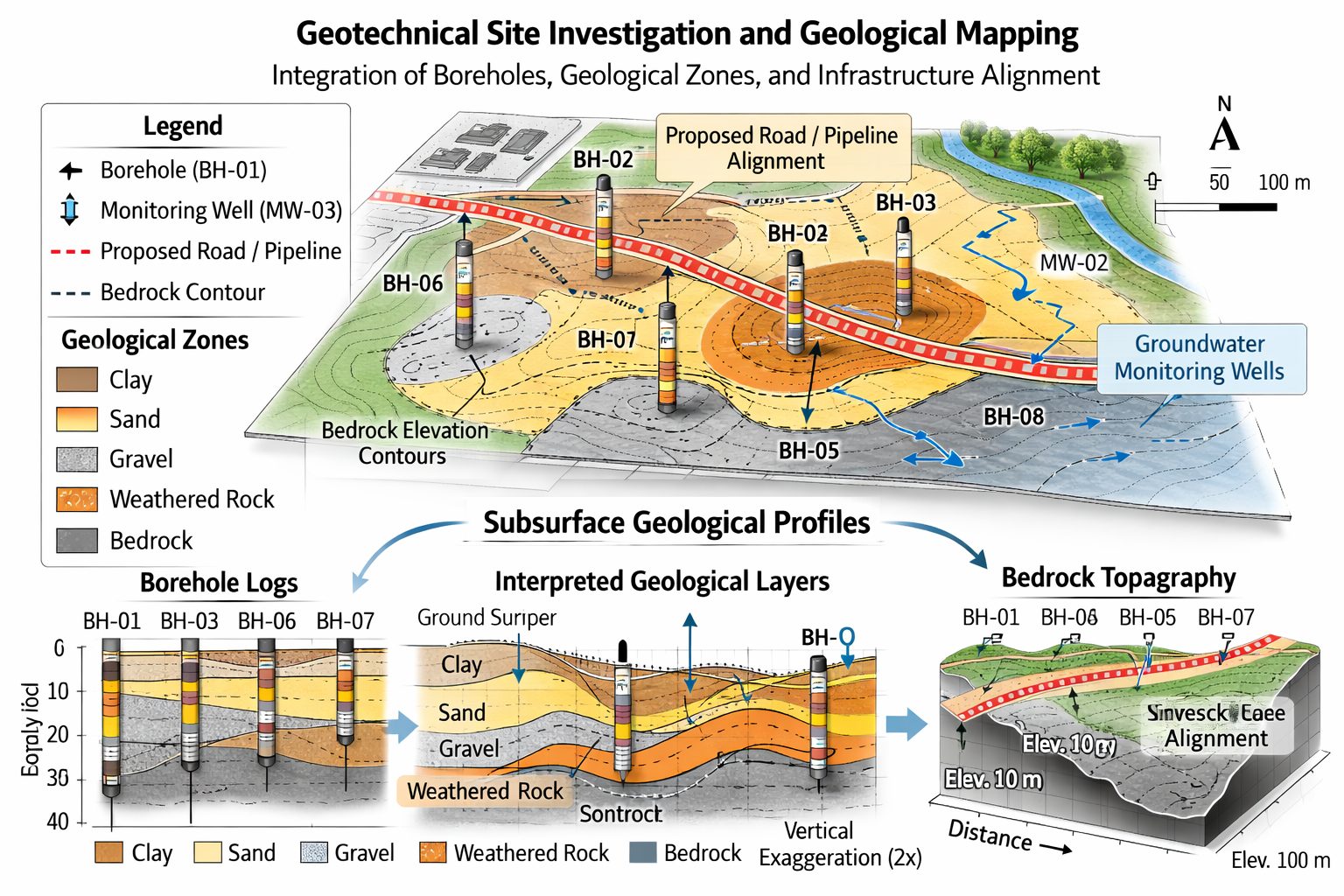
Connecting Borehole Databases to GIS
Borehole databases are the foundation of most subsurface data platforms. Each borehole contains detailed information about geological conditions encountered during drilling.
Typical borehole records include:
- coordinates and elevation
- drilling methods
- lithological descriptions
- sampling intervals
- field test results
- laboratory test data
- groundwater observations
GIS integration allows borehole locations to be displayed on interactive maps.
Users can click on a borehole location to view detailed records, including lithology logs and test results.
Mapping boreholes in GIS provides immediate insight into how subsurface conditions vary across a project site.
Mapping Geological and Geotechnical Data
GIS integration enables geological and geotechnical datasets to be visualized spatially.
Examples include:
- soil type distribution
- bedrock elevation maps
- thickness of geological layers
- groundwater level contours
- geotechnical parameter maps
These spatial visualizations help engineers and geologists identify patterns that may not be apparent from individual borehole records.
For example, GIS mapping may reveal zones of weak soil, areas of shallow bedrock, or groundwater gradients across a site.
This information is critical for infrastructure design and construction planning.
Integrating Environmental Monitoring Data
Environmental investigations often involve monitoring wells and sampling locations distributed across a site.
GIS integration allows environmental data to be visualized alongside geological and geotechnical information.
Examples of environmental datasets include:
- groundwater monitoring wells
- contaminant concentration measurements
- soil sampling locations
- environmental remediation systems
Mapping environmental data in GIS allows professionals to track how contaminants move through subsurface formations.
For example, groundwater contamination plumes can be visualized relative to geological units and groundwater flow directions.
This spatial perspective improves environmental assessment and remediation planning.
Overlaying Infrastructure and Site Data
Engineering and environmental projects often require combining subsurface data with infrastructure information.
GIS integration allows geological data to be overlaid with features such as:
- buildings and foundations
- roads and transportation corridors
- utility networks
- site boundaries and property lines
- topographic surfaces
This integration provides a comprehensive view of the relationship between subsurface conditions and surface infrastructure.
For example, engineers can analyze how soil conditions vary beneath planned building foundations or along proposed pipeline routes.
GIS-Based Spatial Analysis
GIS tools provide powerful spatial analysis capabilities that enhance geological and geotechnical interpretation.
Common GIS analyses include:
Proximity Analysis
This analysis evaluates distances between features.
For example, engineers may analyze how close boreholes are to infrastructure or determine the distance between contamination sources and monitoring wells.
Surface Interpolation
GIS software can interpolate surfaces between boreholes to generate maps such as:
- bedrock elevation
- groundwater levels
- thickness of soil layers
These surfaces help visualize continuous subsurface conditions based on discrete data points.
Contouring and Mapping
GIS platforms can generate contour maps that represent variations in geological or geotechnical properties across a site.
Examples include:
- groundwater elevation contours
- bedrock topography maps
- soil property distribution maps
These maps help engineers understand spatial trends and design appropriate solutions.
Supporting Geological Cross-Sections
GIS integration also supports the creation of geological cross-sections.
Cross-sections represent subsurface conditions along a selected line across a site.
GIS tools allow users to:
- define section lines on maps
- select boreholes near the section line
- project borehole data onto the cross-section
The resulting cross-section displays geological layers, groundwater levels, and sampling data.
By connecting GIS mapping with geological cross-sections, users can easily move between plan views and vertical profiles of subsurface conditions.
Enhancing 3D Subsurface Modeling
Modern geological and geotechnical platforms often include 3D visualization capabilities.
GIS integration provides the spatial framework needed to build accurate 3D models.
3D subsurface models may include:
- borehole traces
- geological surfaces
- stratigraphic volumes
- groundwater surfaces
These models help engineers and geologists understand how geological units extend beneath a site.
3D visualization also improves communication with stakeholders by providing intuitive representations of subsurface conditions.
Benefits of GIS Integration
Integrating GIS into geological and geotechnical data platforms offers several important advantages.
Improved Data Visualization
GIS maps provide clear visual representations of complex datasets.
Users can quickly identify spatial patterns and relationships between geological features.
Better Decision-Making
Spatial analysis helps engineers understand how subsurface conditions affect infrastructure design and environmental management.
This information supports more informed decision-making during project planning and construction.
Enhanced Collaboration
GIS integration allows multiple teams to work with the same spatial datasets.
Geologists, engineers, environmental scientists, and GIS specialists can collaborate using a shared platform.
Efficient Data Management
Centralized GIS-integrated platforms reduce the need for manual data transfers between systems.
This improves efficiency and reduces the risk of data errors.
Long-Term Data Preservation
GIS-integrated databases provide long-term storage for subsurface data.
Historical borehole records, monitoring data, and geological interpretations can be preserved and reused for future projects.
Applications in Engineering and Environmental Projects
GIS-integrated geological platforms support a wide range of applications.
Infrastructure Development
Infrastructure projects such as highways, bridges, tunnels, and buildings require detailed understanding of subsurface conditions.
GIS mapping allows engineers to analyze soil and rock conditions across project corridors.
Environmental Site Assessments
Environmental consultants use GIS to map contamination sources, monitoring wells, and groundwater flow patterns.
This spatial perspective supports effective environmental assessments and remediation strategies.
Groundwater and Hydrogeological Studies
Hydrogeologists use GIS to analyze groundwater levels, aquifer extents, and recharge zones.
GIS-integrated datasets help scientists understand groundwater flow systems.
Mining and Resource Exploration
Mining companies use GIS-integrated platforms to manage drilling data, geological maps, and resource models.
GIS mapping supports exploration planning and resource evaluation.
Future Trends in GIS Integration
Technological advances are expanding the capabilities of GIS-integrated geological platforms.
Cloud-Based GIS Systems
Cloud-based GIS platforms allow users to access spatial data from anywhere.
Cloud systems also improve collaboration between teams working in different locations.
Real-Time Data Integration
Monitoring sensors and automated data collection systems can now feed real-time data into GIS platforms.
This allows professionals to monitor groundwater levels, environmental conditions, and infrastructure performance in near real time.
Advanced 3D and Digital Twin Models
The integration of GIS with 3D geological models is leading to digital twin environments where subsurface conditions are incorporated into infrastructure design models.
These systems may help engineers simulate how geological conditions affect construction and long-term infrastructure performance.
Conclusion
GIS integration plays a critical role in modern geological and geotechnical data platforms. By connecting borehole databases, geological interpretations, environmental monitoring data, and infrastructure information within a spatial framework, GIS enables professionals to better understand subsurface conditions.
Integrated GIS capabilities improve data visualization, enhance spatial analysis, and support more informed engineering and environmental decisions. As subsurface datasets continue to grow in complexity, the ability to analyze them within a geographic context becomes increasingly important.
Organizations that adopt GIS-integrated geological data platforms gain powerful tools for managing subsurface information and interpreting the spatial relationships that shape engineering and environmental projects.
As digital technologies continue to evolve, GIS integration will remain a cornerstone of effective subsurface data management and geological modeling workflows.
Learn more about our Solutions
- GaeaSynergy Platform for Geoscientific Analysis
- Borehole and Well Log Data Management
- Cross Sections and Sub-surface Visualization
- Geotechnical Data Management System
- Environmental Data Management System
Related Articles
- GaeaSynergy: Integrated Geological, Geotechnical, and Environmental Data Management Platform
- The Complete Guide to Borehole Data Solutions
- The Complete Guide to Geotechnical Data Management
- The Complete Guide to Environmental Data Management
- Geological Cross-Sections from Borehole Data: A Complete Engineering Guide
- Integrated Geological and Geotechnical Data Platforms
- Why Engineering Firms Need Integrated Subsurface Data Platforms
- Managing Geological, Geotechnical, and Environmental Data in One Platform
- Digital Platforms for Subsurface Investigation Data
- Connecting Borehole Databases with Geological Modeling Software
- Data Governance in Geological and Engineering Platforms
- The Future of Integrated Subsurface Data Platforms
- How Artificial Intelligence Is Transforming Geotechnical & Environmental Engineering
- Beyond 2D: Integrating Boring Logs with 3D Models for Complex Infrastructure Projects
- Protecting Our Water: Monitoring Contaminant Plumes Through Real-Time Stratigraphic Mapping
- Strategic Data Management in GaeaSynergy
- Seamless Data Flow: Mastering Import and Export in GaeaSynergy
- Mapping the Site: GIS and Spatial Data Management in GaeaSynergy
- Comprehensive Site Intelligence: Integrating Subsurface Data and Infrastructure in GaeaSynergy 3D
- Visualizing the Invisible: 3D Above and Below Ground Structures in GaeaSynergy
- Mastering Subsurface Visualization: Contouring and Gridding in GaeaSynergy
- From Data to Discovery: Visualizing the Subsurface with GaeaSynergy
- GAEA Technologies Software in the Oil & Gas Industry
- Beyond the Surface: How GAEA Technologies Software Powers Modern Mining
- Winning More Bids: Using High-Resolution Subsurface Visualization to Demonstrate Project Certainty
- Selecting the Right Gridding Algorithm for Your Contour Map
- The Science of Doubt: How to Quantify and Visualize Subsurface Uncertainty in Geological Models
- Geoscientific Analysis: Key Uses and Benefits