
Understanding subsurface uncertainty is essential for geologists and engineers, as it influences project outcomes and risk assessment. In this blog post, we will explore how to quantify and visualize subsurface uncertainty in geological models, shedding light on the scientific principles and methodologies you need to navigate this complex topic.
Understanding Subsurface Uncertainty in Geological Models
Subsurface uncertainty is a critical factor in geology and engineering. It refers to the unknowns and variabilities inherent in geological materials and processes below the earth’s surface. These uncertainties can arise from various sources, including:
- Data limitations: Incomplete data collection can lead to gaps in knowledge about subsurface conditions, such as soil composition, groundwater levels, and geological structures.
- Variability in materials: Geological materials are often heterogeneous, meaning their properties can vary significantly over small distances. This variability adds layers of uncertainty to modeling efforts.
- Measurement errors: Inaccurate measurements can introduce bias into geological models, leading to potentially erroneous conclusions.
This uncertainty can have significant implications, especially in fields like civil engineering, resource exploration, and environmental science. For example, in construction, not understanding subsurface conditions can lead to costly overruns or structural failures. Thus, quantifying and visualizing this uncertainty is of utmost importance.
The Importance of Quantifying Uncertainty
Quantifying subsurface uncertainty helps to:
- Inform decision-making: By understanding uncertainties, stakeholders can make more informed decisions regarding project feasibility, risks, and costs.
- Enhance models: Quantifying uncertainty allows for refining geological models, improving their accuracy, and ensuring they reflect real-world conditions.
- Risk management: Identifying and quantifying uncertainties helps mitigate risks associated with geological projects, ultimately reducing liabilities.
- Effective communication: Clear communication of uncertainties to clients and stakeholders plays a crucial role in fostering trust and facilitating project progression.
Methodologies for Quantifying and Visualizing Subsurface Uncertainty
There are several methodologies for quantifying subsurface uncertainty. Here’s a look at some of the most widely used techniques:
1. Probabilistic Methods
Probabilistic methods quantify uncertainty by assigning probabilities to various geological parameters. Some common approaches include:
- Monte Carlo Simulations: This technique uses random sampling to simulate multiple scenarios, allowing for an estimation of the probabilities of different outcomes. By running trains of possible geological scenarios, practitioners can visualize probable distributions of subsurface conditions.
- Bayesian Inference: Bayesian methods allow the integration of prior knowledge with new data, providing an updated probability of uncertainty that reflects current understanding. This method can be particularly useful when combining historical data with newer measurements.
2. Fuzzy Logic
Fuzzy logic helps handle the inherent vagueness of geological data. Unlike traditional binary logic, fuzzy logic allows for degrees of truth, which can capture uncertainty more effectively. Using fuzzy logic models, geologists can represent uncertainties as ranges of possible outcomes rather than fixed values.
3. Geostatistical Approaches
Geostatistics combines spatial statistics with geological modeling, allowing for the representation of uncertainty in space. Key methods include:
- Kriging: This geostatistical method provides estimators of unknown values based on known data, considering both the distance and the degree of variation among geological measurements.
- Sequential Gaussian Simulation: This method generates realizations of the subsurface condition based on geostatistical models, allowing for visualization of uncertainty throughout different layers of the subsurface.
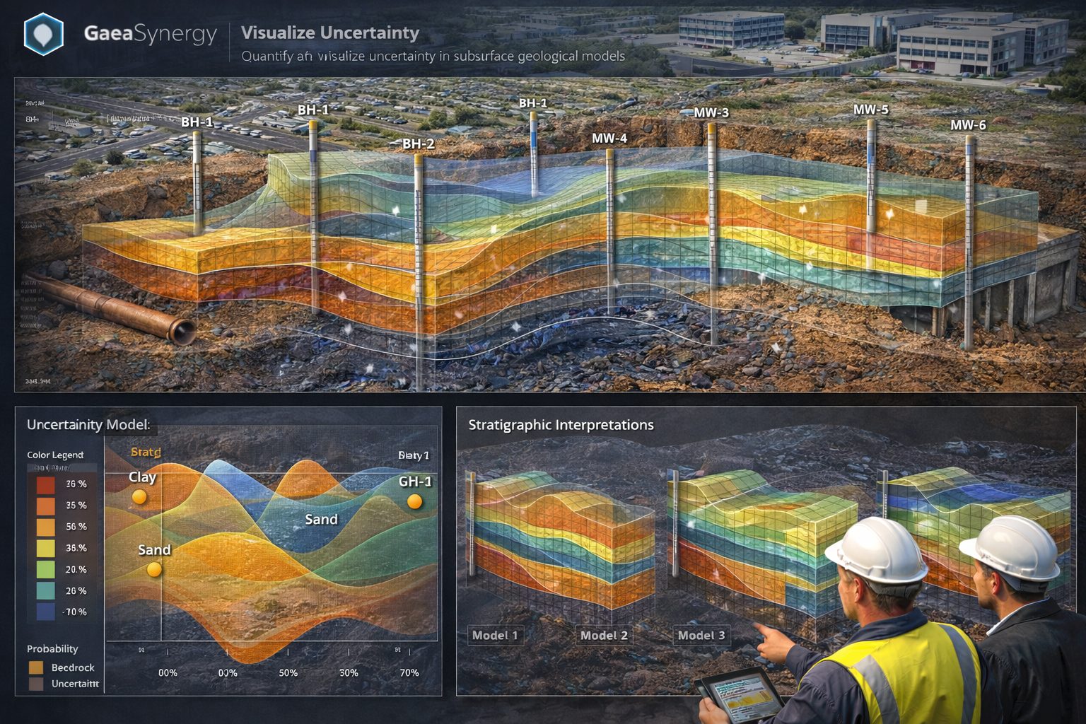
Visualizing Subsurface Uncertainty
Visual representation of subsurface uncertainty is crucial for effective communication among stakeholders. Here are some key techniques for visualizing geological uncertainty:
1. Contour Maps
Contour maps clearly illustrate variations in geological parameters across a spatial extent. These maps can integrate probabilities of various outcomes, emphasizing areas of high and low uncertainty.
2. 3D Models
Three-dimensional models provide a robust visual representation of subsurface conditions, allowing stakeholders to explore uncertainties across different spatial dimensions. By incorporating uncertainty data, these models can show potential variations in real-time.
3. Uncertainty Heatmaps
Uncertainty heatmaps are especially useful to depict areas of high uncertainty. These heatmaps can visually represent probabilities linked to geological parameters, enabling quick assessment of risk zones.
Tools for Quantifying and Visualizing Uncertainty
Several specialized software tools can enhance the quantification and visualization of subsurface uncertainty:
- GaeaSynergy: An application suite for geoscientific analysis, mapping, data display and data management. It uses the synergy within the geoscientific data to effectively and efficiently fulfill the needs of several industries. This tool simplifies the analysis of subsurface conditions across multiple assessment scenarios.
- Geostudio: A suite of geotechnical software for the analysis of slope stability, seepage, and earth structures, helping geotechnical engineers quantify uncertainties in their evaluations.
- GMS (Groundwater Modeling System): This software provides tools for simulating groundwater flow and transport processes, where subsurface uncertainty data can be incorporated into the models.
Challenges Ahead: Overcoming Barriers in Quantifying Uncertainty
Despite the advancements in methodologies and tools, challenges in quantifying and visualizing subsurface uncertainty remain:
- Data Availability: Often, the data needed to accurately model subsurface conditions may not be easily obtainable or outdated.
- Complexity of Geological Systems: The highly variable nature of geological formations can make it difficult to develop accurate models that capture all uncertainties.
- Communication Gaps: Ensuring all stakeholders understand the significance of uncertainty and how it influences decision-making can pose a challenge, highlighting the need for effective communication strategies.
Future Directions in Uncertainty Quantification
The rapidly evolving technological landscape offers promising future directions for improving subsurface uncertainty quantification and visualization:
- Machine Learning: The integration of machine learning algorithms can help automate data processing, making it more efficient to analyze subsurface data and uncover hidden patterns that traditional models may miss.
- Real-time Data Integration: Real-time sensing technologies, such as IoT devices, can provide continuous data feeds, enabling dynamic models that adjust as new information becomes available.
- Collaborative Approaches: Collaborating across disciplines—such as geology, engineering, and data science—can provide more holistic insights into uncertainty quantification.
What Changes Can You Make at Home?
Subsurface uncertainty is an ever-present challenge in geological modeling and decision-making processes. By learning to quantify and visualize subsurface uncertainty better, professionals can enhance project outcomes and reduce risks. Consider implementing these approaches:
- Harness an understanding of the methodologies discussed to refine your geological models, ensuring they capture necessary uncertainties.
- Invest in specialized software tools like GaeaSynergy to visualize and analyze your data effectively.
- Promote open communication with all project stakeholders, clarifying the importance of uncertainty in project planning and execution.
Understanding subsurface uncertainty is essential for propelling our industry forward. By integrating these principles into your practices, you’re not only elevating your technical capabilities but also contributing to a safer and more informed future in geological modeling.
For those eager to explore more about how to optimize your subsurface models and enhance decision-making,
Learn more about our Solutions
- GaeaSynergy Platform for Geoscientific Analysis
- Borehole and Well Log Data Management
- Cross Sections and Sub-surface Visualization
- Geotechnical Data Management System
- Environmental Data Management System
Related Articles
- GaeaSynergy: Integrated Geological, Geotechnical, and Environmental Data Management Platform
- Subsurface Visualization: Turning Borehole Data into Clear Geological Insight
- The Complete Guide to Borehole Data Solutions
- The Complete Guide to Geotechnical Data Management
- The Complete Guide to Environmental Data Management
- Geological Cross-Sections from Borehole Data: A Complete Engineering Guide
- Integrated Geological and Geotechnical Data Platforms
- Why Engineering Firms Need Integrated Subsurface Data Platforms
- Managing Geological, Geotechnical, and Environmental Data in One Platform
- Digital Platforms for Subsurface Investigation Data
- Connecting Borehole Databases with Geological Modeling Software
- GIS Integration in Geological and Geotechnical Data Platforms
- Data Governance in Geological and Engineering Platforms
- The Future of Integrated Subsurface Data Platforms
- How Artificial Intelligence Is Transforming Geotechnical & Environmental Engineering
- Beyond 2D: Integrating Boring Logs with 3D Models for Complex Infrastructure Projects
- Protecting Our Water: Monitoring Contaminant Plumes Through Real-Time Stratigraphic Mapping
- Strategic Data Management in GaeaSynergy
- Seamless Data Flow: Mastering Import and Export in GaeaSynergy
- Mapping the Site: GIS and Spatial Data Management in GaeaSynergy
- Comprehensive Site Intelligence: Integrating Subsurface Data and Infrastructure in GaeaSynergy 3D
- Visualizing the Invisible: 3D Above and Below Ground Structures in GaeaSynergy
- Mastering Subsurface Visualization: Contouring and Gridding in GaeaSynergy
- From Data to Discovery: Visualizing the Subsurface with GaeaSynergy
- GAEA Technologies Software in the Oil & Gas Industry
- Beyond the Surface: How GAEA Technologies Software Powers Modern Mining
- Winning More Bids: Using High-Resolution Subsurface Visualization to Demonstrate Project Certainty
- Selecting the Right Gridding Algorithm for Your Contour Map
- Geoscientific Analysis: Key Uses and Benefits