
Engineering projects rely heavily on understanding subsurface conditions. Whether designing foundations for high-rise buildings, planning transportation infrastructure, or conducting environmental remediation, engineers must interpret complex geological and geotechnical data. Borehole logs, laboratory testing results, groundwater monitoring data, and geological interpretations all contribute to a comprehensive understanding of what lies beneath the ground surface.
However, many engineering firms still manage subsurface data using disconnected tools such as spreadsheets, standalone databases, CAD drawings, and GIS applications. This fragmented approach makes it difficult to maintain data consistency, collaborate across teams, and efficiently interpret subsurface conditions.
Integrated subsurface data platforms provide a solution to these challenges by centralizing geological and geotechnical data within a unified system. These platforms enable engineering firms to manage, analyze, and visualize subsurface information more effectively, ultimately leading to better project outcomes.
This article explores why engineering firms increasingly need integrated subsurface data platforms and how these systems improve data management, project efficiency, and decision-making.
The Growing Complexity of Subsurface Data
Engineering investigations have become more sophisticated over the past several decades. Modern projects generate large volumes of subsurface data from multiple sources, including:
- Borehole drilling programs
- Cone penetration testing (CPT)
- Laboratory soil and rock testing
- Groundwater monitoring wells
- Geophysical surveys
- Geological mapping and interpretations
Each of these activities produces datasets that must be carefully organized and interpreted.
For example, a single infrastructure project may involve hundreds of boreholes, each containing multiple lithological intervals, sampling records, and laboratory test results. When groundwater monitoring and environmental sampling are added to the dataset, the complexity increases further.
Managing this information using spreadsheets or isolated software systems quickly becomes inefficient. Integrated subsurface data platforms allow engineering firms to organize and manage these datasets in a structured environment designed specifically for geological and geotechnical information.
Limitations of Traditional Data Management Approaches
Many engineering firms historically relied on manual workflows for managing subsurface data. While these methods may work for small projects, they become problematic as project size and complexity increase.
Spreadsheet-Based Data Storage
Spreadsheets are commonly used to record borehole logs and laboratory data. While spreadsheets are convenient, they lack the structure needed to maintain complex geological datasets.
Common problems include:
- Inconsistent lithology descriptions
- Duplicate borehole records
- Incorrect depth intervals
- Missing coordinate information
Without strict validation rules, spreadsheet-based systems often accumulate data errors over time.
Disconnected Software Systems
Another common challenge is the use of multiple disconnected tools for different tasks.
For example:
- Borehole data stored in spreadsheets
- Cross-sections created in CAD software
- GIS mapping performed in separate applications
- Laboratory results stored in independent databases
Because these systems do not communicate directly with each other, engineers must repeatedly export and import data between programs. This process increases the risk of data loss and errors.
Data Silos Across Teams
Large engineering projects involve multidisciplinary teams, including:
- Geotechnical engineers
- Engineering geologists
- environmental scientists
- GIS specialists
- project managers
When subsurface data is stored in separate systems, each team may maintain its own version of the dataset. This fragmentation leads to data silos that make collaboration more difficult.
Integrated subsurface data platforms eliminate these silos by providing a shared environment where all teams access the same centralized dataset.
What Is an Integrated Subsurface Data Platform?
An integrated subsurface data platform is a software system designed to manage geological, geotechnical, and environmental data within a unified database environment.
These platforms combine several capabilities into a single solution, including:
- Borehole database management
- GIS mapping and spatial analysis
- Geological cross-section generation
- subsurface interpolation and contouring
- environmental monitoring data management
- 3D subsurface visualization
By integrating these functions, the platform becomes the central hub for all subsurface information associated with a project or organization.
Instead of transferring data between multiple tools, engineers can manage and analyze data within a single environment.
Centralized Borehole Data Management
Borehole data forms the foundation of most geotechnical investigations. An integrated platform provides a structured database specifically designed to store drilling information.
Typical borehole database fields include:
- Borehole coordinates
- ground surface elevation
- drilling method and equipment
- lithological descriptions
- sampling intervals
- Standard Penetration Test (SPT) values
- laboratory test results
Structured databases enforce consistent data formats and validation rules. For example, lithology codes may be standardized across projects, and depth intervals must follow logical sequences.
Centralized borehole databases also allow engineers to search and retrieve historical data quickly, which is valuable for regional studies and future projects.
Integration of Geological and Geotechnical Data
Subsurface investigations involve multiple types of data that must be interpreted together.
Integrated platforms link these datasets within a unified framework, allowing engineers to analyze relationships between:
- lithology
- laboratory test results
- groundwater levels
- geotechnical parameters
- engineering classifications
For example, laboratory test results can be directly associated with the depth interval and geological unit from which a sample was collected.
This integration helps engineers understand how geological conditions influence soil behavior and engineering properties.
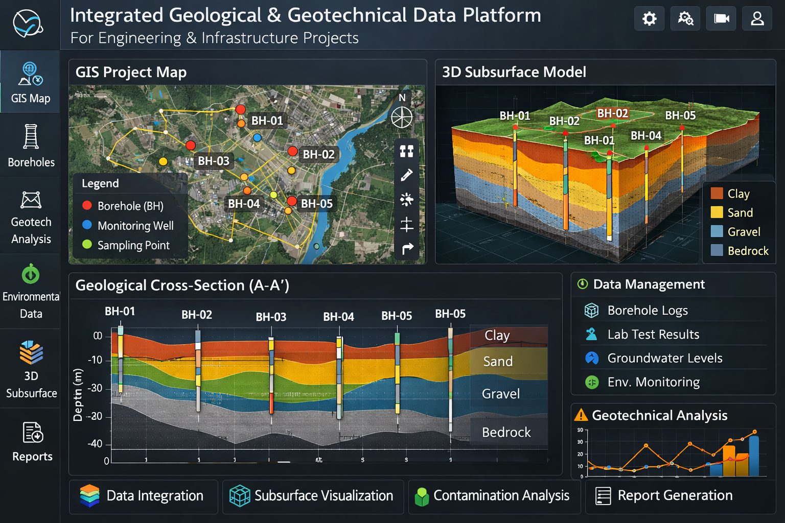
GIS Mapping and Spatial Analysis
Spatial context is essential for interpreting subsurface conditions. Integrated platforms typically incorporate Geographic Information System (GIS) capabilities that allow users to visualize data geographically.
GIS functions include:
- mapping borehole locations
- displaying site boundaries and infrastructure
- integrating topographic and aerial imagery
- overlaying geological maps
By viewing borehole data within a spatial framework, engineers can better understand patterns in soil and rock distribution.
GIS integration also allows organizations to combine subsurface data with other datasets such as land use, environmental constraints, or infrastructure networks.
Geological Cross-Sections and Subsurface Profiles
Geological cross-sections are one of the most common tools used to interpret subsurface conditions.
Integrated platforms allow engineers to generate cross-sections directly from the borehole database.
Features typically include:
- automatic projection of boreholes onto section lines
- visualization of lithological units
- display of sampling and test data
- geological interpretation tools
Because cross-sections are generated from the central database, they remain consistent with the underlying data.
If new boreholes are added or existing records are updated, the cross-section can be regenerated instantly.
Gridding, Contouring, and Surface Modeling
Engineering projects often require the interpolation of subsurface surfaces between boreholes.
Integrated platforms provide tools for generating:
- bedrock elevation maps
- groundwater surface maps
- thickness maps of soil layers
- contour maps of geotechnical parameters
These interpolated surfaces help engineers visualize spatial variations in subsurface conditions.
Accurate surface models support foundation design, excavation planning, and groundwater management.
3D Subsurface Visualization
Three-dimensional visualization is becoming increasingly important for complex projects.
Integrated subsurface platforms allow users to create 3D representations of boreholes, geological layers, and groundwater surfaces.
Benefits of 3D visualization include:
- improved interpretation of geological structures
- better communication with stakeholders
- enhanced understanding of subsurface variability
For large infrastructure projects, 3D models can significantly improve coordination between geotechnical teams and design engineers.
Environmental and Monitoring Data Integration
Many engineering firms also conduct environmental investigations and monitoring programs.
Integrated platforms allow environmental data to be stored alongside geological and geotechnical information.
Examples include:
- groundwater monitoring wells
- water level measurements
- contaminant concentration data
- soil and groundwater sampling results
Time-series monitoring data can be linked to spatial locations and geological units, enabling more comprehensive environmental analysis.
This integration is particularly valuable for contaminated site investigations and long-term monitoring programs.
Improved Data Quality and Validation
One of the most important benefits of integrated platforms is improved data quality.
Structured databases enforce validation rules that prevent common errors such as:
- incorrect coordinate systems
- invalid depth intervals
- duplicate borehole identifiers
- inconsistent lithology codes
Quality control tools allow organizations to standardize how data is entered and stored across projects.
High-quality data leads to more reliable geological interpretations and engineering designs.
Enhanced Collaboration Across Teams
Integrated subsurface data platforms provide a centralized environment where multiple teams can access and work with the same dataset.
This improves collaboration between:
- geotechnical engineers
- engineering geologists
- environmental specialists
- GIS analysts
- project managers
Because all users work with the same database, there is less risk of conflicting information or outdated data.
Collaboration is particularly important for large infrastructure projects that involve multiple stakeholders and consultants.
Increased Efficiency and Productivity
Engineering professionals often spend a significant amount of time managing and organizing data.
Integrated platforms reduce these administrative tasks by automating many workflows.
For example, engineers can:
- import drilling data directly into the database
- automatically generate cross-sections and reports
- create contour maps from borehole data
- visualize subsurface conditions in 3D
By reducing manual data handling, integrated platforms allow professionals to focus on analysis and interpretation.
Long-Term Value of Subsurface Data
Subsurface investigations represent a significant investment for engineering projects.
Drilling programs, laboratory testing, and monitoring systems can cost hundreds of thousands of dollars. Preserving this data for future use is therefore extremely valuable.
Integrated platforms allow organizations to maintain long-term databases of subsurface information.
Historical borehole data can support future projects such as:
- infrastructure expansion
- regional geological studies
- environmental assessments
- urban development planning
Centralized databases ensure that this information remains accessible and usable for many years.
Risk Reduction in Engineering Projects
Accurate understanding of subsurface conditions is critical for managing project risk.
Poorly interpreted geological data can lead to costly problems such as:
- unexpected soil conditions
- foundation failures
- groundwater inflow during construction
- environmental contamination issues
Integrated subsurface data platforms improve the reliability of geological interpretations by providing comprehensive access to all available data.
Better data management leads to more informed engineering decisions and reduced project risk.
Scalability for Large Engineering Firms
Large engineering firms often manage thousands of boreholes and monitoring locations across multiple projects and regions.
Integrated platforms are designed to handle large datasets efficiently.
Features such as centralized databases, user management systems, and project-based data organization allow organizations to scale their data management capabilities as they grow.
These systems also support collaboration across multiple offices and teams.
The Future of Subsurface Data Management
Technological advances are continuing to transform how subsurface data is managed and analyzed.
Several emerging trends are shaping the future of integrated platforms.
Cloud-Based Data Platforms
Cloud technology allows organizations to access subsurface databases from anywhere.
Cloud-based systems improve collaboration and allow distributed teams to work with the same datasets in real time.
Automated Data Collection
Drilling equipment, laboratory systems, and monitoring sensors are increasingly capable of exporting data directly into digital systems.
Automated data integration reduces manual entry and improves data accuracy.
Advanced Data Analytics
Machine learning and advanced analytics are beginning to play a role in geological interpretation.
These technologies may help identify patterns in large datasets and improve predictive modeling of subsurface conditions.
Conclusion
Engineering firms rely on accurate and well-organized subsurface data to design safe infrastructure and manage environmental challenges. Traditional approaches to managing geological and geotechnical information often involve disconnected systems that create inefficiencies, data errors, and collaboration challenges.
Integrated subsurface data platforms provide a powerful solution by centralizing borehole data, laboratory results, GIS mapping, geological interpretations, and monitoring data within a unified environment.
These platforms improve data quality, streamline workflows, enhance collaboration, and preserve valuable geological information for future use. As engineering projects become more complex and data volumes continue to grow, integrated subsurface data platforms are becoming essential tools for modern engineering firms.
Organizations that adopt these systems gain a significant advantage in managing subsurface information and making informed decisions about the ground conditions that affect infrastructure, environmental protection, and long-term development.
Learn more about our Solutions
- GaeaSynergy Platform for Geoscientific Analysis
- Borehole and Well Log Data Management
- Cross Sections and Sub-surface Visualization
- Geotechnical Data Management System
- Environmental Data Management System
Related Articles
- GaeaSynergy: Integrated Geological, Geotechnical, and Environmental Data Management Platform
- The Complete Guide to Borehole Data Solutions
- The Complete Guide to Geotechnical Data Management
- The Complete Guide to Environmental Data Management
- Geological Cross-Sections from Borehole Data: A Complete Engineering Guide
- Integrated Geological and Geotechnical Data Platforms
- Managing Geological, Geotechnical, and Environmental Data in One Platform
- Digital Platforms for Subsurface Investigation Data
- Connecting Borehole Databases with Geological Modeling Software
- GIS Integration in Geological and Geotechnical Data Platforms
- Data Governance in Geological and Engineering Platforms
- The Future of Integrated Subsurface Data Platforms
- How Artificial Intelligence Is Transforming Geotechnical & Environmental Engineering
- Beyond 2D: Integrating Boring Logs with 3D Models for Complex Infrastructure Projects
- Protecting Our Water: Monitoring Contaminant Plumes Through Real-Time Stratigraphic Mapping
- Strategic Data Management in GaeaSynergy
- Seamless Data Flow: Mastering Import and Export in GaeaSynergy
- Mapping the Site: GIS and Spatial Data Management in GaeaSynergy
- Comprehensive Site Intelligence: Integrating Subsurface Data and Infrastructure in GaeaSynergy 3D
- Visualizing the Invisible: 3D Above and Below Ground Structures in GaeaSynergy
- Mastering Subsurface Visualization: Contouring and Gridding in GaeaSynergy
- From Data to Discovery: Visualizing the Subsurface with GaeaSynergy
- GAEA Technologies Software in the Oil & Gas Industry
- Beyond the Surface: How GAEA Technologies Software Powers Modern Mining
- Winning More Bids: Using High-Resolution Subsurface Visualization to Demonstrate Project Certainty
- Selecting the Right Gridding Algorithm for Your Contour Map
- The Science of Doubt: How to Quantify and Visualize Subsurface Uncertainty in Geological Models
- Geoscientific Analysis: Key Uses and Benefits