
As engineering and environmental projects generate increasingly large volumes of digital data, managing that information responsibly has become a critical challenge. Geological and engineering platforms now handle vast datasets that include borehole logs, geotechnical laboratory results, GIS mapping layers, environmental monitoring data, and three-dimensional subsurface models. These datasets support infrastructure design, environmental protection, and long-term resource management.
However, without clear policies and systems for managing data, organizations risk inconsistencies, data loss, security issues, and reduced confidence in analytical results. Data governance provides the framework needed to ensure that geological and engineering data remains accurate, secure, accessible, and usable over time.
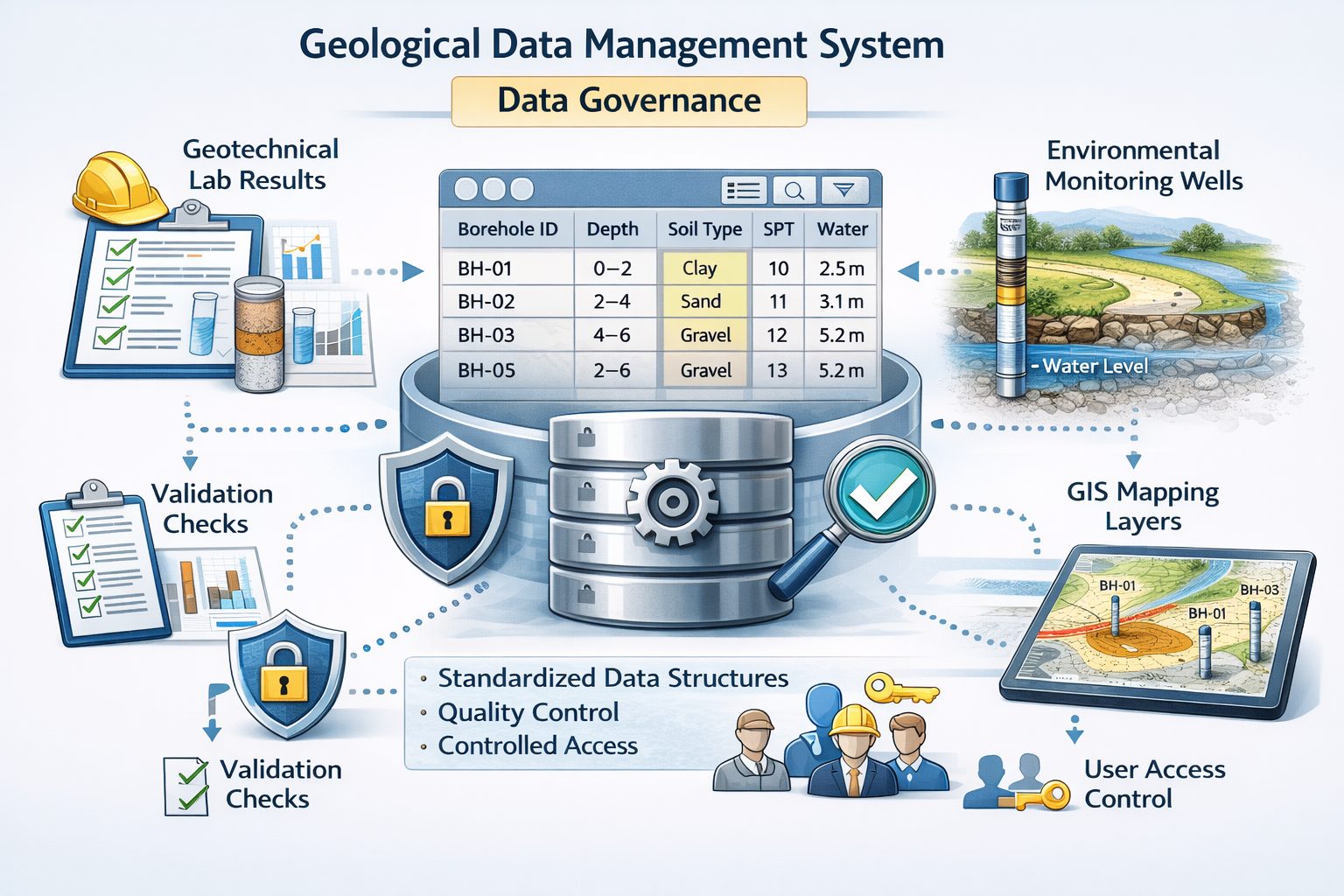
In geological and engineering platforms, data governance encompasses policies, processes, and technologies that control how subsurface data is collected, stored, validated, shared, and maintained. Effective governance ensures that organizations can trust the information used to support engineering decisions and environmental management.
This article explores the importance of data governance in geological and engineering platforms, the key components of effective governance frameworks, and best practices for managing subsurface data responsibly.
The Importance of Data Governance in Subsurface Data Management
Geological and engineering projects rely heavily on accurate subsurface information. Borehole data, geotechnical test results, and environmental monitoring measurements all contribute to the understanding of ground conditions and environmental risks.
Poor data management can lead to serious consequences, including:
- inaccurate geological interpretations
- incorrect engineering designs
- environmental compliance issues
- loss of valuable historical data
Data governance helps organizations maintain control over their datasets and ensure that information remains reliable throughout the lifecycle of a project.
In modern engineering workflows, where digital platforms integrate multiple datasets, governance frameworks are essential for maintaining consistency across teams and projects.
What Is Data Governance?
Data governance refers to the policies, standards, and procedures that regulate how data is managed within an organization.
In geological and engineering platforms, data governance typically addresses several key objectives:
- ensuring data accuracy and consistency
- protecting sensitive information
- defining responsibilities for data management
- establishing standards for data collection and storage
- maintaining long-term accessibility of data
Data governance is not only a technical process but also an organizational strategy that involves collaboration between engineers, geologists, data managers, and IT specialists.
Effective governance frameworks ensure that everyone involved in a project understands how data should be handled and maintained.
Types of Data Managed in Geological and Engineering Platforms
Geological and engineering platforms typically manage multiple types of data related to subsurface investigations.
Borehole Data
Borehole drilling programs produce detailed records of subsurface conditions.
Typical borehole datasets include:
- coordinates and elevations
- lithological descriptions
- drilling methods
- sampling intervals
- Standard Penetration Test (SPT) values
- laboratory test results
Because borehole data forms the foundation of geological interpretations, maintaining its accuracy is essential.
Geotechnical Testing Data
Laboratory and field tests provide engineering properties for soil and rock materials.
Examples include:
- shear strength tests
- consolidation tests
- grain size analysis
- Atterberg limits
- density measurements
These datasets are used for engineering design and must be carefully linked to the samples and boreholes from which they were obtained.
Geological Interpretations
Geologists interpret borehole data to identify geological units and structures.
Interpretation datasets may include:
- stratigraphic units
- geological contacts
- faults and fractures
- geological surfaces and models
These interpretations are often used in cross-sections and 3D models.
Environmental Monitoring Data
Environmental investigations generate monitoring datasets that track conditions over time.
Examples include:
- groundwater level measurements
- contaminant concentrations
- soil sampling results
- monitoring well records
Because environmental data may be used for regulatory reporting, strong governance practices are essential.
GIS Spatial Data
Geological and engineering platforms often integrate GIS mapping layers such as:
- borehole locations
- geological maps
- infrastructure data
- topographic surfaces
GIS datasets provide spatial context for subsurface investigations.
Core Components of Data Governance
Effective data governance frameworks consist of several key components.
Data Standards
Data standards define how information should be structured and recorded.
Examples of standards include:
- lithology classification systems
- coordinate system conventions
- naming conventions for boreholes and samples
- units of measurement for laboratory tests
Standardization ensures that datasets remain consistent across projects and teams.
Data Validation and Quality Control
Quality control processes help detect and correct errors in datasets.
Common validation checks include:
- verifying coordinate accuracy
- confirming depth intervals do not overlap
- identifying duplicate borehole records
- checking that lithology codes follow approved classifications
Automated validation tools within geological data platforms can significantly improve data quality.
Access Control and Security
Not all datasets should be accessible to every user.
Data governance frameworks often include access control systems that define who can view, edit, or manage specific datasets.
For example:
- geologists may edit lithology data
- environmental specialists may manage monitoring datasets
- project managers may have read-only access
Access controls help protect sensitive information and prevent unauthorized data modifications.
Data Ownership and Responsibility
Clear data ownership ensures that someone is responsible for maintaining the accuracy and integrity of datasets.
Typical roles in data governance may include:
- data stewards who oversee data quality
- database administrators who manage technical systems
- subject matter experts who validate technical interpretations
Defining these roles helps maintain accountability.
Version Control and Change Management
Subsurface datasets often evolve over time as new boreholes are drilled and interpretations are updated.
Version control systems track changes to datasets and allow users to review historical records.
Change management procedures help ensure that updates are documented and reviewed before being incorporated into official datasets.
Implementing Data Governance in Geological Platforms
Implementing data governance requires both technical tools and organizational policies.
Centralized Data Platforms
Integrated geological data platforms provide centralized databases for storing subsurface information.
Centralized systems reduce data fragmentation and make it easier to enforce governance policies.
Automated Data Validation
Modern platforms include automated validation tools that check for common errors during data entry.
For example, the system may prevent users from entering invalid depth intervals or inconsistent coordinate systems.
Workflow Management
Governance frameworks often include workflows that guide how data moves through the system.
For example:
- field data is collected during drilling
- data is entered into the borehole database
- validation checks confirm accuracy
- geologists review and interpret data
- approved datasets are used in modeling and analysis
These workflows ensure that data is properly reviewed before being used for engineering decisions.
Benefits of Strong Data Governance
Organizations that implement effective data governance frameworks gain several advantages.
Improved Data Quality
Standardized data structures and validation processes reduce errors and inconsistencies.
High-quality datasets lead to more reliable geological interpretations and engineering designs.
Better Collaboration
When data governance policies are clearly defined, teams can collaborate more effectively.
Shared standards ensure that datasets remain compatible across disciplines.
Regulatory Compliance
Environmental and infrastructure projects often require regulatory reporting.
Governance frameworks help ensure that monitoring data and documentation meet regulatory requirements.
Long-Term Data Preservation
Subsurface investigations represent significant investments.
Governance policies ensure that historical data remains accessible and usable for future projects.
Reduced Risk
Reliable data reduces the risk of engineering errors and environmental mismanagement.
Organizations can make more confident decisions when they trust the data supporting those decisions.
Applications Across Engineering and Environmental Projects
Data governance is essential across many industries.
Infrastructure Development
Large infrastructure projects generate extensive subsurface datasets.
Governance frameworks help manage these datasets throughout the design and construction phases.
Environmental Consulting
Environmental investigations rely on accurate monitoring data and sampling records.
Strong governance ensures that environmental datasets remain reliable for regulatory reporting.
Mining and Resource Exploration
Mining companies manage large volumes of drilling and geological data.
Governance frameworks help maintain consistency across exploration programs.
Groundwater and Hydrogeology Studies
Hydrogeologists analyze monitoring data and geological information to understand groundwater systems.
Governance policies ensure that datasets remain accurate and accessible.
Future Trends in Data Governance
As digital technologies continue to evolve, data governance practices are also changing.
Cloud-Based Data Platforms
Cloud systems allow organizations to store geological datasets securely and provide controlled access to distributed teams.
Automated Data Integration
Modern drilling equipment and monitoring sensors can transmit data directly to digital platforms.
Automated integration reduces manual entry and improves accuracy.
Advanced Data Analytics
Machine learning and advanced analytics tools may assist with identifying errors or inconsistencies in large datasets.
These technologies could enhance quality control processes.
Conclusion
Data governance is a critical component of modern geological and engineering platforms. As subsurface datasets grow in size and complexity, organizations must implement clear policies and systems to ensure that data remains accurate, secure, and accessible.
Effective governance frameworks address data standards, quality control, access management, and long-term preservation. By combining organizational policies with advanced digital platforms, engineering and environmental professionals can manage subsurface data responsibly and efficiently.
Strong data governance not only improves data quality but also enhances collaboration, supports regulatory compliance, and reduces project risk. As digital technologies continue to transform subsurface data management, governance frameworks will remain essential for ensuring that geological and engineering data can be trusted to support critical decisions.
Learn more about our Solutions
- GaeaSynergy Platform for Geoscientific Analysis
- Borehole and Well Log Data Management
- Cross Sections and Sub-surface Visualization
- Geotechnical Data Management System
- Environmental Data Management System
Related Articles
- GaeaSynergy: Integrated Geological, Geotechnical, and Environmental Data Management Platform
- The Complete Guide to Borehole Data Solutions
- The Complete Guide to Geotechnical Data Management
- The Complete Guide to Environmental Data Management
- Geological Cross-Sections from Borehole Data: A Complete Engineering Guide
- Integrated Geological and Geotechnical Data Platforms
- Why Engineering Firms Need Integrated Subsurface Data Platforms
- Managing Geological, Geotechnical, and Environmental Data in One Platform
- Digital Platforms for Subsurface Investigation Data
- Connecting Borehole Databases with Geological Modeling Software
- GIS Integration in Geological and Geotechnical Data Platforms
- The Future of Integrated Subsurface Data Platforms
- How Artificial Intelligence Is Transforming Geotechnical & Environmental Engineering
- Beyond 2D: Integrating Boring Logs with 3D Models for Complex Infrastructure Projects
- Protecting Our Water: Monitoring Contaminant Plumes Through Real-Time Stratigraphic Mapping
- Strategic Data Management in GaeaSynergy
- Seamless Data Flow: Mastering Import and Export in GaeaSynergy
- Mapping the Site: GIS and Spatial Data Management in GaeaSynergy
- Comprehensive Site Intelligence: Integrating Subsurface Data and Infrastructure in GaeaSynergy 3D
- Visualizing the Invisible: 3D Above and Below Ground Structures in GaeaSynergy
- Mastering Subsurface Visualization: Contouring and Gridding in GaeaSynergy
- From Data to Discovery: Visualizing the Subsurface with GaeaSynergy
- GAEA Technologies Software in the Oil & Gas Industry
- Beyond the Surface: How GAEA Technologies Software Powers Modern Mining
- Winning More Bids: Using High-Resolution Subsurface Visualization to Demonstrate Project Certainty
- Selecting the Right Gridding Algorithm for Your Contour Map
- The Science of Doubt: How to Quantify and Visualize Subsurface Uncertainty in Geological Models
- Geoscientific Analysis: Key Uses and Benefits