
Photographs are one of the most powerful tools available to Environmental Professionals (EPs) conducting a Phase I Environmental Site Assessment (ESA). While written observations, historical records, and interviews form the backbone of the assessment, photographic documentation transforms those findings into verifiable, defensible evidence.
Under standards such as ASTM E1527-21 and regulatory frameworks like the EPA’s All Appropriate Inquiries (AAI) rule, photographs are not simply an enhancement—they are a core component of professional due diligence. They provide a visual record of site conditions, support the identification of Recognized Environmental Conditions (RECs), and strengthen the credibility of the final report.
This article explores the critical role photographs play in Phase I ESAs, including:
- Evidence and verification of site conditions
- Contextualization and clarity
- Legal and professional compliance
- Best practices for photographic documentation
Why Photographs Matter in a Phase I ESA
A Phase I ESA is inherently non-intrusive, meaning it relies on observation and documentation rather than physical sampling. In this context, photographs serve as:
- Objective evidence of observed conditions
- A permanent record of site features at a specific point in time
- Visual support for conclusions and recommendations
- A communication tool for stakeholders who have not visited the site
Without photographs, a Phase I ESA becomes heavily reliant on narrative interpretation. With photographs, it becomes transparent, verifiable, and defensible.
I. Evidence and Verification of Site Conditions
Providing Objective, Verifiable Evidence
The primary purpose of photographs is to provide objective evidence of conditions observed during site reconnaissance.
While written descriptions are essential, they are inherently subjective. Photographs, by contrast:
- Capture real conditions without interpretation
- Allow third parties to independently evaluate findings
- Reduce ambiguity in the report
For example, describing “dark staining on pavement” is informative—but a photograph of that staining provides clear, irrefutable proof.
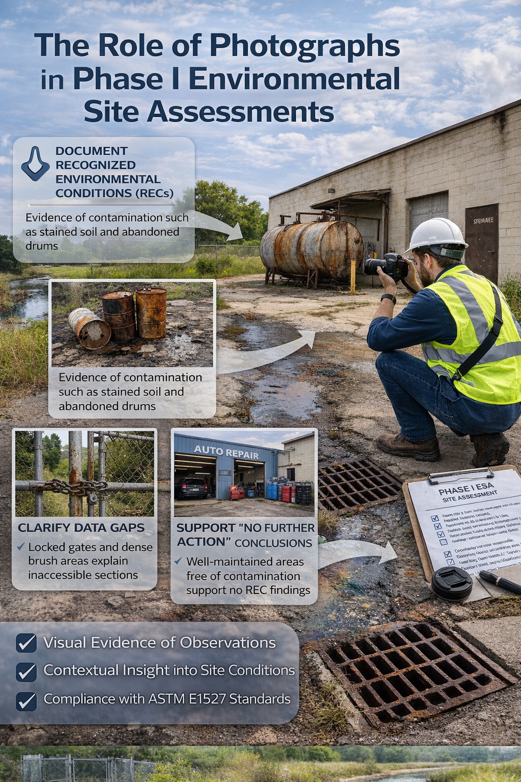
Documentation of Recognized Environmental Conditions (RECs)
Photographs are especially critical when documenting Recognized Environmental Conditions (RECs).
A REC is defined as:
The presence or likely presence of hazardous substances or petroleum products due to a release, past release, or material threat of release.
Common examples of photographic evidence supporting RECs include:
- Discolored or oil-stained soil
- Stressed or dead vegetation
- Corroded or leaking storage tanks
- Abandoned drums or containers
- Oily sheens on standing water
These images:
- Substantiate written observations
- Strengthen the justification for identifying a REC
- Provide clarity to clients, regulators, and reviewers
Without photographic evidence, the identification of a REC may be questioned or require additional explanation.
Verification of Current Site Use
Photographs also play a key role in confirming current site operations and land use.
Examples include:
- Active industrial processes
- Commercial operations (e.g., auto repair, fueling stations)
- Vacant or undeveloped land
- Residential or mixed-use properties
These images help:
- Validate the site description in the report
- Confirm consistency with historical records
- Identify ongoing potentially contaminating activities
For instance, a photograph of an active repair shop with oil storage containers provides clear evidence of current petroleum use.
Supporting “No Further Action” Conclusions
Photographs are equally important when no environmental concerns are identified.
Documenting clean, well-maintained areas can:
- Support conclusions that no RECs are present
- Reinforce recommendations that no further investigation is required
- Increase client confidence in the assessment
For example:
- Clean storage areas with proper containment
- Intact pavement with no staining
- Well-maintained drainage systems
These images demonstrate that the EP conducted a thorough inspection and found no evidence of concern.
II. Contextualization and Clarity
Enhancing Understanding of Site Layout
Photographs provide critical context for understanding the physical layout of the property.
General site images may include:
- Building exteriors
- Parking areas
- Loading docks
- Adjacent properties
These visuals help readers:
- Orient themselves to the site
- Understand spatial relationships between features
- Visualize potential contaminant pathways
This is especially important for stakeholders who have not visited the site.
Illustrating Potential Contaminating Activities (PCAs)
Photographs are highly effective in illustrating Potentially Contaminating Activities (PCAs).
Examples include:
- Fueling operations
- Chemical storage areas
- Industrial manufacturing processes
- Agricultural pesticide use
By visually documenting these activities, photographs help:
- Identify Areas of Potential Environmental Concern (APECs)
- Support conclusions about contamination risk
- Provide clear examples for report reviewers
For instance, an image of a truck wash area with visible runoff can indicate a potential source of contamination.
Clarifying Complex Observations
Some site conditions are difficult to fully describe in text. Photographs provide clarity by:
- Showing exact conditions and features
- Highlighting subtle indicators (e.g., slight staining, minor corrosion)
- Demonstrating relationships between multiple elements
For example:
- A drainage ditch receiving runoff from an industrial area
- A storage tank located near a storm drain
- A cracked concrete floor in a chemical storage room
These visuals allow readers to quickly understand complex environmental scenarios.
Documenting Data Gaps
Photographs also play a crucial role in documenting data gaps.
Data gaps may occur when:
- Areas are inaccessible (locked buildings, restricted zones)
- Dense vegetation limits visibility
- Safety concerns prevent entry
Photographs of these conditions:
- Provide visual justification for the limitation
- Demonstrate due diligence by the EP
- Increase transparency in the report
For example, a photo of a locked gate clearly shows why a portion of the site could not be inspected.
III. Legal and Professional Compliance
Meeting Industry Standards
Including photographs is considered part of the standard of care for Phase I ESAs.
Although ASTM E1527-21 does not explicitly mandate photographs in every instance, it requires documentation “to the extent feasible.” In practice, this means:
- Photographs are expected in professional reports
- Their absence may raise questions about completeness
- They are essential for meeting industry expectations
A report without photographs may be viewed as lacking rigor or thoroughness.
Supporting Regulatory Compliance
Photographs also support compliance with regulatory frameworks such as:
- EPA’s All Appropriate Inquiries (AAI) rule
- Environmental due diligence requirements for property transactions
By providing clear documentation of site conditions, photographs help demonstrate that:
- The assessment was conducted thoroughly
- Observations were properly recorded
- Conclusions are supported by evidence
Minimizing Liability
One of the most important functions of photographs is risk management.
Clear, time-stamped images provide:
- A record of site conditions at the time of assessment
- Protection against future disputes
- Evidence supporting environmental conclusions
This is particularly important for:
- Establishing “innocent landowner” defenses
- Supporting “bona fide prospective purchaser” protections
- Defending against liability under environmental laws such as CERCLA
In legal contexts, photographs can serve as critical evidence.
Best Practices for Photographic Documentation
To maximize their effectiveness, photographs must be collected and presented properly.
What to Photograph
Environmental Professionals should capture:
- General site overviews
- Building exteriors and interiors
- Storage areas and equipment
- Drainage features and surface water
- Evidence of contamination (staining, odors, vegetation stress)
- Adjacent properties
- Data gaps and inaccessible areas
Both areas of concern and areas with no issues should be documented.
Image Quality and Consistency
Photographs should be:
- Clear and well-lit
- Properly framed and focused
- Taken from multiple angles when necessary
- Consistent in style and format
Poor-quality images can reduce credibility and limit usefulness.
Time-Stamping and Organization
All photographs should:
- Include date and time information
- Be labeled with location and description
- Be organized logically within the report
Captions should clearly explain what is shown and why it is relevant.
Integration into the Report
Photographs should not be an afterthought. They must be:
- Integrated with the narrative
- Referenced in relevant sections
- Used to support key findings
For example:
“As shown in Photo 5, staining was observed adjacent to the storm drain…”
This linkage strengthens the report’s clarity and impact.
Common Mistakes to Avoid
Even experienced professionals can make errors in photographic documentation. Common mistakes include:
- Failing to photograph key features or concerns
- Including too few images
- Using low-quality or blurry photos
- Not labeling or organizing images properly
- Including photos without context or explanation
Avoiding these issues is essential for producing a high-quality report.
The Role of Photographs in Decision-Making
Photographs directly influence decision-making by:
- Helping clients understand site conditions
- Supporting recommendations for further investigation
- Providing evidence for lenders and regulators
- Reducing uncertainty in property transactions
In many cases, photographs are the most accessible and impactful part of the report for non-technical stakeholders.
Conclusion
Photographs are an indispensable component of a Phase I Environmental Site Assessment. They provide objective evidence, enhance clarity, and support compliance with industry standards and regulatory requirements.
By documenting both environmental concerns and areas of no concern, photographs:
- Strengthen the identification of RECs
- Improve communication with stakeholders
- Provide legal protection and risk mitigation
- Elevate the overall quality and defensibility of the report
In a process that relies heavily on observation and interpretation, photographs bridge the gap between narrative and reality. For any Phase I ESA to be truly effective, comprehensive and well-executed photographic documentation is essential.
👉 Learn more about our Automated Environmental Site Assessment Solution
Related Articles
- Overview of a Phase I Environmental Site Assessment (ESA): A Complete Guide for Due Diligence
- Key Uses of a Phase I Environmental Site Assessment
- Market for Phase I Environmental Site Assessments
- The Role of Historical Source Review in Phase I Environmental Site Assessments
- The Role of Environmental Database Reviews in Phase I Environmental Site Assessments
- The Review of Property Records in a Phase I Environmental Site Assessment
- The Role of Visual Inspections in a Phase I Environmental Site Assessment
- Identifying Hazardous Substances and Petroleum Products in a Phase I Environmental Site Assessment
- Documenting Drainage Patterns and Surface Water in a Phase I Environmental Site Assessment
- The Use of Drones in a Phase I Environmental Site Assessment
- Conducting Interviews with Property Owners and Occupants for a Phase I ESA
- Conducting Interviews with Government Officials for a Phase I ESA
- Conducting Interviews with Neighbors for a Phase I ESA
- Key Components of a Phase I ESA Conclusion
- Key Distinctions Between ASTM E1527-21 and CSA Z768-01