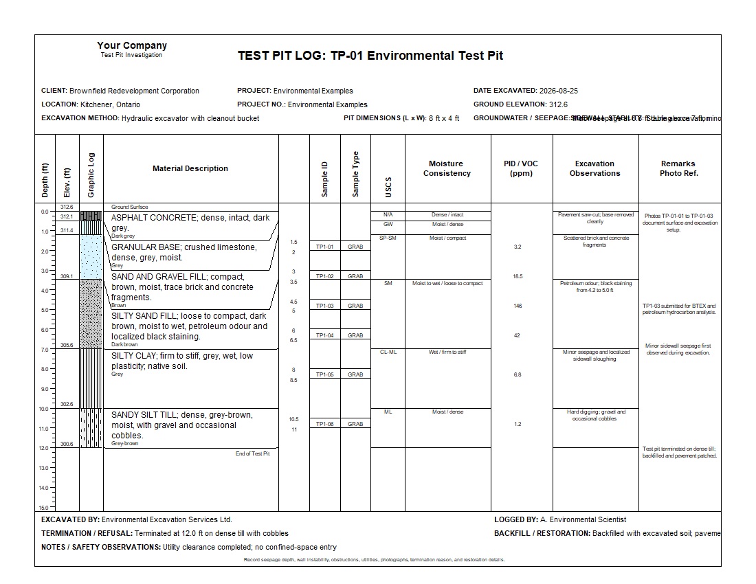
A complete shallow-excavation record combining pavement and fill, native soil, grab samples, USCS classifications, PID/VOC screening, seepage, excavation observations, photographs, and restoration details.
TP-01 Environmental Test Pit represents an environmental assessment at a former service-station property in Kitchener, Ontario. The 12 ft excavation progresses from asphalt and granular base through heterogeneous fill and petroleum-impacted silty sand into native silty clay and dense sandy silt till.
The validation report records 100% completeness, Good quality, and an 84% confidence score. One warning identifies the 146 ppm PID/VOC result at 4.75 ft for confirmatory review; no errors were reported.
The profile begins with asphalt and granular base, passes through fill containing brick and concrete fragments, and reaches a petroleum-impacted silty-sand interval between 3.5 and 7.0 ft. Below this zone, the excavation encounters native wet silty clay followed by dense sandy silt till with gravel and cobbles.
The 146 ppm PID/VOC reading at 4.75 ft produces one appropriate validation warning. The log documents that sample TP1-03 was submitted for BTEX and petroleum-hydrocarbon analysis, demonstrating how WinLoG connects field observations, screening results, and follow-up decisions.
Download the files individually. The XML template and test-pit log can be imported into WinLoG Version 6 and customized for environmental assessments, brownfield investigations, spill response, and shallow subsurface programs.
Documents shallow soil conditions, evidence of impacts, field screening, sample collection, groundwater seepage, and laboratory follow-up.
Provides a concise record for redevelopment investigations, due diligence, source-area assessment, remedial planning, and excavation oversight.
Supports coordinated review of stratigraphy, sample depths, screening results, visible impacts, confirmatory testing, and completeness.
WinLoG templates can be adapted for company standards, regulatory programs, and project-specific field forms. Headers, sample columns, screening datasets, lithology, excavation observations, photographs, and validation rules can all be tailored to environmental workflows.
Contact GAEA Technologies
GAEA Technologies develops and distributes geoscience and engineering solutions worldwide. Our solutions have been used for over 30 years by companies and organizations around the world.
© 2026 - All Rights Reserved/span>