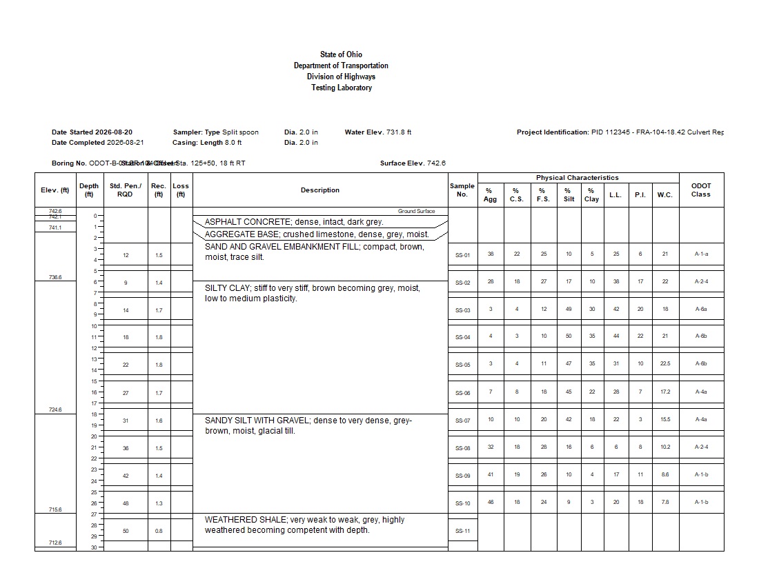
This example shows how WinLoG organizes subsurface information for Ohio transportation projects. ODOT-B-01 SR 104 Culvert presents pavement structure, embankment fill, native soils, eleven split-spoon samples, SPT N-values, recovery and sample loss, water content, Atterberg Limits, five grain-size fractions, ODOT classifications, elevations, and water-elevation information on a professional DOT-style log.
The 30 ft Columbus, Ohio borehole supports an SR 104 culvert replacement and includes asphalt concrete, aggregate base, sand and gravel embankment fill, silty clay, dense sandy silt with gravel, and weathered shale. Automated validation passes with 100% completeness, Good quality, 85% confidence, and no informational messages, warnings, or errors.
This record demonstrates how pavement, aggregate base, embankment fill, native soil, and sampling data can be interpreted beside SPT results, recovery, sample loss, water content, Atterberg Limits, grain-size fractions, ODOT classifications, elevations, and groundwater information. All datasets share a common depth scale for efficient transportation and geotechnical review.
The supplied validation report records Passed status, 100% completeness, Good quality, an 85% confidence score, zero informational messages, zero errors, and zero warnings.
Download the example files individually. The XML template and log can be imported into WinLoG Version 6 and customized for transportation and agency-specific workflows.
Demonstrates a practical workflow combining pavement structure, lithology, SPT, recovery, sample loss, moisture, Atterberg Limits, grain-size data, and ODOT classifications for transportation design.
Shows how moisture, Atterberg Limit, grain-size, sampling, recovery, and classification results can share a common depth-based presentation.
Provides an integrated record for reviewing SPT, recovery, loss, moisture, Atterberg Limits, grain-size distributions, ODOT classifications, and completeness together.
WinLoG templates can be customized to match company standards, project requirements, and agency formats. Ohio DOT-style headers, sampling columns, physical-characteristic fields, water-content displays, and validation rules can be tailored to project and organization requirements.
Contact GAEA Technologies
GAEA Technologies develops and distributes geoscience and engineering solutions worldwide. Our solutions have been used for over 30 years by companies and organizations around the world.
© 2026 - All Rights Reserved/span>