WinLoG Ontario MOT Borehole Example

WinLoG Ontario MOT highway borehole log View Full Log
Ontario MOT Borehole Log
1-page log Validation Passed
ONTARIO MOT HIGHWAY INVESTIGATION EXAMPLE

WinLoG Ontario MOT Borehole Example

A complete 10 m Ontario MOT-style highway borehole with pavement, fill, sampling, penetration, moisture, strength, density, and grain-size data.

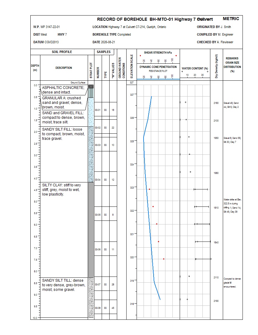
This example shows how WinLoG organizes the subsurface information used for Ontario transportation projects. BH-MTO-01 Highway 7 Culvert presents pavement structure, fill and native soils, eight split-spoon samples, SPT N-values, dynamic cone penetration, shear strength, water content, Atterberg Limits, dry density, grain-size results, elevations, and field remarks on a professional MOT-style log.

The 10 m Guelph, Ontario borehole supports a Highway 7 culvert investigation and includes asphaltic concrete, granular base, sand and gravel fill, sandy silt fill, silty clay, and dense sandy silt till. Automated validation passes with 88% completeness, Good quality, 81% confidence, and no errors or warnings.

Geotechnical Ontario MOT Format SPT Dynamic Cone Penetration Water Content Split-spoon Samples Atterberg Limits Shear Strength Dry Density Grain-size Distribution Validation Passed XML Template

Download Complete Example Back to Example Library

Capabilities Demonstrated

What This Ontario MOT Borehole Example Shows

Borehole Logging

  • Lithology and descriptions
  • Lithologic symbols
  • Sample intervals and numbers
  • Sample type
  • Depth and elevation columns
  • Six material intervals to 10 m

Field Testing

  • SPT N-values
  • Sample recovery
  • Eight split-spoon samples
  • SPT N-values from 8 to 45
  • Recovery from 70% to 90%
  • Dynamic cone penetration profile

Index Testing

  • Depth-linked water-content results
  • Plastic and Liquid Limits
  • Water-content range bars
  • Plasticity Index results
  • Depth-linked graph display
  • Field and laboratory context

Engineering & Validation

  • Shear-strength results
  • Dry-density profile and water-strike remark
  • Domain and completeness checks
  • Cross-dataset consistency
  • No errors or warnings
  • Validation reporting

An Integrated Transportation Borehole Dataset

This record demonstrates how pavement, granular base, fill, native soil, and sampling data can be interpreted beside dynamic cone penetration, shear strength, water content, Atterberg Limits, dry density, grain-size distribution, elevations, and drilling observations. All datasets share a common depth scale for efficient transportation and foundation-engineering review.

The supplied validation report records Passed status, 88% completeness, Good quality, an 81% confidence score, zero errors and zero warnings.

Example Data

Key Datasets Demonstrated

Stratigraphy and Samples

  • Asphalt, granular base, fill, silty clay, and sandy silt till
  • Six depth-continuous material intervals
  • Eight split-spoon sample intervals
  • Dynamic cone penetration plotted on a continuous depth profile
  • SPT N-values, recovery percentages, and sample symbols

Index and Engineering Properties

  • Water content and Atterberg Limit profiles
  • Plasticity Index calculated and plotted by depth
  • Shear-strength results through cohesive soils
  • Dry-density values from 1810 to 2190 kg/m³
  • Water strike, grain-size distributions, and drilling observations

Download the Complete Example

Download the example files individually. The XML template and log can be imported into WinLoG Version 6 and customized for transportation and agency-specific workflows.

Included in the Example

  • Professional single-page Ontario MOT-style borehole log
  • Geotechnical validation report
  • Reusable XML template
  • Ontario MOT highway borehole XML data
  • SPT, dynamic cone penetration, water content, Atterberg, shear strength, dry density, grain-size, and remarks datasets
Applications

Who This Example Is For

Geotechnical Consultants

Demonstrates a practical workflow combining pavement structure, lithology, SPT, penetration resistance, moisture, strength, density, grain-size data, and drilling observations for transportation design.

Laboratory and Field Teams

Shows how moisture, Atterberg Limit, dynamic cone penetration, shear-strength, sampling, and dry-density results can share a common depth-based presentation.

QA/QC Reviewers

Provides an integrated record for reviewing SPT, penetration, recovery, moisture, Atterberg Limits, strength, dry density, grain-size data, and completeness together.

Customize This Ontario MOT Borehole Example

WinLoG templates can be customized to match company standards, project requirements, and agency formats. MOT-style headers, sampling columns, penetration and strength graphs, water-content displays, and validation rules can be tailored to project and organization requirements.

Contact GAEA Technologies